Despite its name, the Canadian Tuxedo is a distinctly American look. The denim-on-denim getup dates back to the 1950s, when Bing Crosby sported a full Levi’s ensemble while in Vancouver, setting a sartorial trend that continues today.
The national mythology woven into this utilitarian material is also the focus of Brooklyn-based Nick Doyle, who layers denim atop denim into large wall sculptures. From a pair of aviators reflecting puffy clouds to a vast Rocky Mountain landscape framed by br
Despite its name, the Canadian Tuxedo is a distinctly American look. The denim-on-denim getup dates back to the 1950s, when Bing Crosby sported a full Levi’s ensemble while in Vancouver, setting a sartorial trend that continues today.
The national mythology woven into this utilitarian material is also the focus of Brooklyn-based Nick Doyle, who layers denim atop denim into large wall sculptures. From a pair of aviators reflecting puffy clouds to a vast Rocky Mountain landscape framed by brick, the works evoke a sort of nostalgic road trip west, as if chasing a big break, and ultimately, realizing the American dream.
“First Come the Dreamers” (2026), bleached and collaged denim on panel, 25 x 72 inches
For Doyle, denim is a poignant, loaded metaphor for much of American culture and history. The material has roots in chattel slavery, when people enslaved in the South were dyeing cotton with indigo. There’s also its association with the brusque masculinity of James Dean and cowboy ruggedness, itself an extension of the gold rush and Manifest Destiny. The fabric, in many ways, is a stand-in for the contradictions, hypocrisies, and unreachable desires so bound up in American life.
While researching the visual language of Americana in 2018, Doyle came upon a roll of denim discarded by a fashion designer moving out of his building. “At the time, I had no money, so I was making work out of material I found in the garbage or at my local hardware store,” he shares. “As I was pulling [the roll] out of the trash, I noticed a network of ideas connecting in my brain… I felt the material reflected the historical complexities I was seeing in my research, as well as being reflected in my own familial history.”
This encounter was one of those providential moments that set off an enduring fascination. In his solo exhibition Collective Hallucinations, on view at Perrotin, Doyle presents the latest of his denim sculptures, including stylized cacti, landscapes cordoned off by chainlink fences, and more mystical objects like tarot cards and a life-sized fortune teller’s shop.
“Innocent Industry” (2026), bleached and collaged denim on panel, 72 x 64 inches
The show contains myriad symbols of American exceptionalism and individualism, presented in the heritage fabric of the nation. Doyle shares:
Over the last few years, my conception of American mythology has only become more complex… I think in a lot of ways what we’re experiencing now is a breakdown of these mythologies. They are in direct conflict with the current political reality, yet they are summoned as if it is business as usual. The world’s image of America has changed, but our country’s nostalgia for itself is making us late to the party. There’s tragedy in vanity.
Collective Hallucinations presents these unrealized dreams and confrontations in varying shades of blue, rendering what appears to be individual moments as simply different washes of the same story.
In addition to his practice, Doyle will soon open the second iteration of a kink bar called Human Resources at Basel Social Club and is working toward a fall exhibition of paper collages and prints at Pace. If you’re in New York, Collective Hallucinations runs through May 30. Otherwise, find more on Instagram.
“Here We Go Round the Prickly Pear Bush” (2026), bleached and collaged denim on panel, 48 x 26 inches“The Clouds” (2026), bleached denim on panel, 24 x 18 inches“Plastic Eden” (2026), bleached and collaged denim on panel, 68 x 42 inches“Black Market Bodies” (2026), bleached and collaged denim on panel, 36 x 64 inches
Research & Developments is a blog for brief updates that provide context for the flurry of news that impacts science and scientists today.
In the contiguous United States, crop irrigation, municipal water supplies, and thermoelectric power generation use more than 224 billion gallons of fresh water every day. Conducting water research or making decisions about water use, until now, often required referencing datasets across various agencies. The U.S. Geological Survey (USGS) National
Research & Developments is a blog for brief updates that provide context for the flurry of news that impacts science and scientists today.
In the contiguous United States, crop irrigation, municipal water supplies, and thermoelectric power generation use more than 224 billion gallons of fresh water every day. Conducting water research or making decisions about water use, until now, often required referencing datasets across various agencies. The U.S. Geological Survey (USGS) National Water Availability Assessment Data Companion (NWDC), announced this week, aims to streamline this process. In part, the tool is designed to help decisionmakers better understand the balance between how high demand and limited supply affect water availability in their communities.
“While the United States has abundant water nationally, regional imbalances between supply and demand may create water challenges affecting millions of Americans,” said lead scientist Shirley Leung in a USGSpress release. “What once required significant resources and time can now be done in minutes, giving communities of all sizes the same foundation for water planning.”
The lower 48 states are home to about 80,000 sub-watersheds, from those in the arid southwest to the Great Lakes Basin, where about 84% of North America’s surface fresh water is located. According to the USGS, the NWDC is the first tool that integrates information about water availability in individual watersheds at a national scale.
The tool is designed to complement Water Data for the Nation (WDFN), another USGS product that consolidates observational data from the agency’s thousands of local monitoring stations gathering data on streams, lakes, reservoirs, precipitation, water quality, and groundwater. The new tool uses modeling to fill in spatial and temporal gaps between the observations made at these stations.
Water managers, researchers, agricultural experts, and others can use the NWDC to compare watershed conditions, identify seasonal patterns in water use, or to create data visualizations of statewide water use, for example. Though the tool currently covers only the contiguous United States, it will soon be extended to Alaska, Hawaii, and Puerto Rico, according to the USGS.
David Tarboton, a professor of civil engineering at the Utah Water Research Laboratory, said he was “intrigued” by the new tool, and is interested in examining the data its model produces.
While Tarboton was disappointed that the tool’s most recent available data are from 2020, “having a sort of integrated, wall-to-wall dataset that’s consistently produced is very valuable,” he said. He works, in part, in the areas of hydroinformatics and data sharing, and noted that the modern methods the agency is using to share the data could be useful in developing automated tools.
These updates are made possible through information from the scientific community. Do you have a story about science or scientists? Send us a tip at eos@agu.org.
ShutterNut... posted a photo:
Please be aware... Photos are purely for entertainment. I am no expert. Titles are from recognition - what I was told - or a quick search. Polite comments or corrections are welcome.
Please be aware... Photos are purely for entertainment. I am no expert. Titles are from recognition - what I was told - or a quick search. Polite comments or corrections are welcome.
A wonderful new paper on the huge Tracy Arm landslide and tsunami will have profound but challenging implications for the management of risk in an age of increased tourism and rapid climate change.
The journal Science has published an excellent new paper (Shugar et al. 2026) that examines the extraordinary 10 August 2025 landslide and tsunami at Tracy Arm fjord in Alaska. The paper is open access, so you can read it for yourself (it is very accessible), and there has been a plethora
A wonderful new paper on the huge Tracy Arm landslide and tsunami will have profound but challenging implications for the management of risk in an age of increased tourism and rapid climate change.
The journal Science has published an excellent new paper (Shugar et al. 2026) that examines the extraordinary 10 August 2025 landslide and tsunami at Tracy Arm fjord in Alaska. The paper is open access, so you can read it for yourself (it is very accessible), and there has been a plethora of media coverage (quite rightly).
That large landslides occur in fjords is not a surprise, and that they can generate enormous displacement waves is also not news. We know that landslide occurrence in these environments in general is increasing, and specifically so in Alaska. However, this paper is the most comprehensive and systematic analysis of such an event, and it has shown the remarkable threat that these events can generate. The tsunami created by this landslide had a 481 metre run-up; it is remarkable that there were no fatalities. If a large cruise ship had been in the area, with passengers being ferried ashore on small boats and exploring the shoreline, the consequences would have been catastrophic. It is unsurprising then that cruise companies are now amending their itineraries.
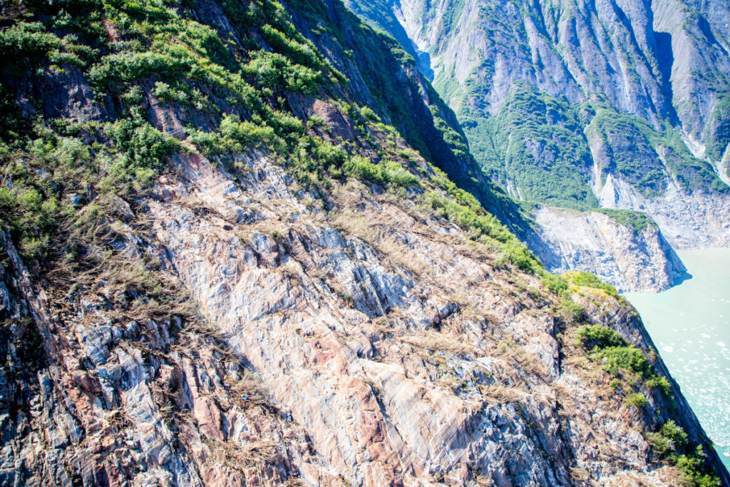
The USGS released the image below of the aftermath of the landslide and tsunami – scale is hard to understand in such images, but the crown of the landslide is over 1,000 metres above the level of the fjord, and the landslide had a subaerial volume of over 63 million cubic metres.
This aerial photo shows the north side of Alaska’s Tracy Arm Fjord in the aftermath of the 2025 landslide and tsunami. The lighter-colored rock is the exposed surface, where the mountainside collapsed and fell into the water. The foot of South Sawyer Glacier is visible at lower right; in decades past, the ice extended much farther and was thick enough to hold the rock slopes in place. Credit: Cyrus Read/U.S. Geological Survey
Shugar et al. (2026) has a brief section that examines the implications of this event, and of the understanding that it provides of the hazards posed by very large landslides in fjord settings. These are locations with extensive human activity – local communities, trade, fishing and tourism. There is some evidence that these landsldies are more likely to occur in the spring and summer months, when human occupation is higher. Our resilience to a tsunami wave that starts off being hundreds of metres high is low.
A case in point lies in Milford Sound in New Zealand, where (for example) an earthquake on the Alpine Fault has the potential to trigger a large landslide that could result in a major tsunami. Milford Sound is an extremely popular tourism location. Should such an event occur, and mass fatalities result, there is no doubt that the public inquiry would find that the societal risk was known and that it was probably unacceptable. However, to ban tourism, including cruise ships, in this area would carry heavy risks in its own right – it would profoundly impact the vital tourist economy of the area, on which many livelihoods depend. This is a substantial risk in its own right, and of course politics plays a major part too. Balancing these risks is a major challenge for any society.
Some hope is offered by the fact that this landslide showed substantial precursory seismic activity, which might represent a route to providing a warning for at least some of these rock slope failures. But research in this area is immature at the moment, and of course there will be no warning for a landslide triggered by a major earthquake.
So, the landslide at Tracy Arm fjord presents us with a host of major challenges, but it also represents a big step forward in our understanding of these events. Well done to Dan and his colleagues for another brilliant paper. I shall watch the debate with great interest.
One year after the Trump administration launched its tariff offensive against more than 180 countries, Latin America presents a mixed picture: some economies lost competitiveness in the U.S. market, while others redirected exports or negotiated agreements to cushion the blow.
One year after the Trump administration launched its tariff offensive against more than 180 countries, Latin America presents a mixed picture: some economies lost competitiveness in the U.S. market, while others redirected exports or negotiated agreements to cushion the blow.