Source: Water Resources Research
This is an authorized translation of an Eos article. 本文是Eos文章的授权翻译。
如果人类想要在太空生活,无论是在航天器里还是在火星上,首先要解决的一个问题就是如何获取水,来满足饮用、卫生需求以及为维持生命所需的植物提供水分。即便只是将水运送到近地轨道上的国际空间站(ISS),也需要花费数万美元。因此,找到在太空中高效、持久且可靠地获取和再利用水资源的方法,对于长期在太空居住至关重要。
目前的系统,比如国际空间站上的环境控制与生命支持系统(ECLSS),为闭合式水回收提供了蓝图,但它们还需要改进才能适应未来的应用。与此同时,近期的技术和科学进步正为在严苛环境下寻找、净化和管理水资源开辟新的途径。在一篇新的综述中,Olawade等人概述了地外水资源管理的现状,以及该领域的前景和挑战。
作者指出,太空水系统需要具备闭环、高效和持久耐用的特性,同时还要满足低能耗的要求。目前,ECLSS能耗过高,其效率可能也不足以满足长期任务的需求。未来建议采用的过
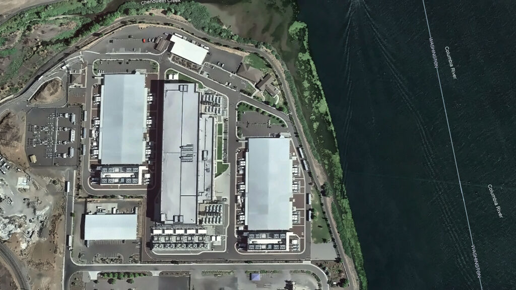
Every chip fabricated in a semiconductor plant needs ultrapure water. Most nuclear reactors need water as a coolant and neutron moderator. Every artificial intelligence (AI) data center drinks between 1 million and 5 million gallons of water a day, with thirst often peaking during drought.
Water runs through every technology priority the United States has named, yet the word does not appear once in “Launching the Genesis Mission,” an executive order (EO) released in November 2025. As describ
Every chip fabricated in a semiconductor plant needs ultrapure water. Most nuclear reactors need water as a coolant and neutron moderator. Every artificial intelligence (AI) data center drinks between 1 million and 5 million gallons of water a day, with thirst often peaking during drought.
Water runs through every technology priority the United States has named, yet the word does not appear once in “Launching the Genesis Mission,” an executive order (EO) released in November 2025. As described in the EO, the Genesis Mission is a “dedicated, coordinated national effort to unleash a new age of AI-accelerated innovation and discovery that can solve the most challenging problems of this century.”
Led by the Department of Energy (DOE), the initiative aims to build an integrated AI framework that would harness federal scientific datasets to accelerate breakthroughs in advanced manufacturing, biotechnology, critical materials, nuclear fission and fusion energy, quantum information science, and semiconductor development. The scope of the mission is comparable to that of the Manhattan Project.
Since the announcement, the DOE has listed “Predicting U.S. Water for Energy” among its 26 Genesis Mission Science and Technology Challenges. The project is also soliciting proposals in three water-related focus areas.
This framework provides a foothold for hydrology in the Genesis Mission, but it is scoped narrowly around water as a supply variable for energy production.
In reality, water is a crosscutting constraint that will help determine whether the mission’s priorities translate into deployable outcomes. The hydrology community now has a seat at the table, and if it moves first and positions water security as one of the “most challenging problems of this century,” the Genesis Mission can become the sandbox in which AI reshapes how the country measures, models, and manages water.
Making this happen will require that the DOE and the Office of Science and Technology Policy charter a hydrology workstream inside the Genesis Mission, with interagency delivery involving the U.S. Geological Survey (USGS), NOAA, the Bureau of Reclamation, the EPA, and partners at state, regional, and community levels. Here is what we think that workstream should look like:
A water-centric Genesis Mission architecture supports seven hydrological components that both feed into and receive decisions from the Genesis AI platform. Each component maps to a section of this article. Credit: Amobichukwu C. Amanambu. Click image for larger version.
While the existing challenges reflect some of these components, others will require coordinated effort from the hydrology community to bring into the Genesis Mission’s scope.
Build the Water Corpus Genesis Will Need
The Genesis Mission EO instructs the DOE to create an American Science and Security Platform to provide the public, scientists, agencies, and policymakers access to crucial scientific datasets.
The good news is that accessible water data systems already exist across several federal agencies and academic research centers. The USGS National Water Information System tracks real-time and historical water quality and use across the country. NASA’s Earth Science Data Systems Program provides open access to Earth science observations. NOAA’s National Water Center, the first federal facility dedicated to national water resource forecasting, operates the National Water Model, which continuously forecasts flows on 2.7 million stream reaches across the continental United States. The Catchment Attributes and Meteorology for Large-Sample Studies (CAMELS) dataset, currently hosted by the National Center for Atmospheric Research, provides data tailored for hydrological research on hundreds of river basins, and the Caravan framework pulls together multiple large-sample meteorological and hydrological datasets at a global scale.
What is missing is a unified, AI-ready repository that brings federal, state, and community data together.
What is missing is a unified, AI-ready repository that brings federal, state, and community data together. Building one is hard. Water data are fragmented, inconsistent, and often entirely absent. Consistent, reliable data for groundwater, withdrawals, reservoir operations, and water quality are especially difficult to obtain.
Local resistance to sharing data is real. In Texas, for example, landowners hold private property rights over groundwater and have opposed metering and reporting requirements imposed by groundwater conservation districts. In California, agricultural well owners fought metering mandates for years before the Sustainable Groundwater Management Act compelled local agencies to begin tracking withdrawals. Tribal nations face a different concern: Water data collected on Indigenous lands has been misrepresented in federal datasets that were modeled without accounting for Indian country, leading many nations to restrict access to their data as an exercise of sovereignty.
Practical steps toward building a unified AI-ready repository include tiered access and licensing for different stakeholders, clear provenance tracking for all data reported, financial and educational incentives for stakeholders for reporting, and targeted gap filling. Where measurements are missing, AI can fuse remote sensing with gauged records and operational logs—but only if the results carry honest uncertainty estimates tied to real decisions.
Get the corpus right, and it will outlive any single program name. It becomes infrastructure the country can lean on.
Develop Shared Hydrologic Foundation Models
The Genesis Mission EO directs the DOE to provide “domain-specific foundation models across the range of scientific domains covered.”
Hydrology has a head start. Long short-term memory (LSTM) networks are a key type of neural network designed to last thousands of time steps. Hydrology LSTMs trained on CAMELS data have already matched traditional conceptual models for daily streamflow discharge prediction. Open-source Neural Hydrology tools serve as baselines for regional runoff prediction. These predictions may serve as precursors to the foundation models the Genesis Mission envisions and building blocks from which they could be developed.
The process of scaling up these tools is not straightforward, however. A hydrologic investigation of snowmelt-driven streams in Colorado will not require the same spatiotemporal data as tile-drained fields in Iowa, for example. A hydrology-specific foundation model must take nuanced requirements into consideration and provide a clear path for managing and exploiting a variety of datasets.
Google’s Flood Hub shows what is possible: Its AI-enabled flood forecasts now cover more than 80 countries. However, Flood Hub’s core model code and trained weights remain proprietary, meaning researchers can use the forecasts but cannot rebuild or adapt the underlying models. Genesis, if well positioned, can fill that accessibility gap by producing foundation models for water that are reusable, reliable, and openly governed.
Build a National Water Digital Twin
The EO prescribes an integrated AI platform combining foundation models with simulation tools to stimulate AI-enabled innovations.
That architecture is exactly what a digital twin requires. Europe’s Destination Earth initiative is already building digital twins for weather extremes and nonstationary conditions on the Large Unified Modern Infrastructure (LUMI) supercomputer. The United Nations–led AI for Good initiative has prioritized water applications, warning that fragmented national efforts risk duplicating work.
If the United States aims for global strategic leadership in AI-accelerated science, water infrastructure cannot be an afterthought.
A water digital twin earns its keep when it makes the consequences of choices visible, in terms of flows, levels, temperatures, and risks to people and ecosystems.
Rather than starting from scratch, a water-centric Genesis Mission would unite existing federal models—the National Water Model, reservoir simulators, and groundwater codes—in a single digital twin. AI can become the thread that stitches them together, correcting biases and providing numerical solvers to enforce mass and energy balance.
What should this twin actually do? Help a dam operator decide whether to release water ahead of a storm. Tell planners where a new data center can draw cooling water without drying up a stream. Flag which coastal defenses will fail first under rising seas.
A water digital twin earns its keep when it makes the consequences of choices visible, in terms of flows, levels, temperatures, and risks to people and ecosystems.
Turn Basins into AI Test Beds
The Genesis Mission promotes AI-directed experimentation and directs the DOE to keep a record of robotic laboratories and production facilities in which such experimentation could be conducted. Hydrological field sites belong in that inventory. The National Ecological Observatory Network already operates 81 sites with standardized measurements of meteorology, surface water, groundwater, and biodiversity. The Critical Zone Collaborative Network instruments catchments to track water-soil-vegetation interactions over decades.
Formalizing these networks as AI test beds would link field observations back into the water digital twin so that experiments and models continually sharpen each other. Imagine mobile sensors steered by AI agents during a storm or aquifer recharge experiments designed by algorithms and verified in real time. That feedback loop is what separates a useful model from a decorative one.
Expand Water Challenges on the Genesis Mission List
The Exchange and What’s at Stake
Allowing water security to flow through the diverse components of the Genesis Mission would benefit both the policies championed by the mission itself and the hydrology community.
The Genesis Mission gets real-world, noisy test beds where AI proves value beyond benchmarks, a domain to stress test climate and infrastructure investments, and scientists trained in both AI and the stubborn realities of rivers, aquifers, and pipes.
Hydrology gets resources for shared data infrastructure, foundation models and instrumented basins no single lab can support, a seat when rules for AI and national scientific infrastructure are negotiated, and a chance to reset practices around openness, collaboration, and equity.
Earlier this year, the DOE released 26 Genesis Mission Science and Technology Challenges, and “Predicting U.S. Water for Energy” was among them. The accompanying funding call (DE-FOA-0003612) solicits proposals on cloud microphysics, coupled surface water–groundwater modeling, and seasonal to multiyear prediction, all framed around energy needs and flood resilience.
These inclusions are a significant win for a hydrology component to Genesis, but several urgent challenges sit outside their scope. Can AI close the gap between a flood forecast issued 12 hours out and the 48 hours emergency managers actually need? Can it map compound extremes, in which drought, heat, and infrastructure failure collide in the same week? Can it redesign monitoring networks so that coverage follows risk rather than where gauges happened to be installed a century ago? Integrating energy and water systems is equally urgent: Floods have caused 80% of major U.S. grid outages since 2000, while drought-driven water stress curtails cooling at thermoelectric plants and reduces hydropower output, exposing how deeply energy infrastructure depends on hydrologic extremes.
The water footprint of new AI infrastructure deserves a place on that list. A separate executive order (14318, “Accelerating Federal Permitting of Data Center Infrastructure”) is already fast-tracking expansion of data center construction, and a single hyperscale facility can consume 1 million to 5 million gallons of water daily. Emerging research shows how withdrawals at that scale can push streams below ecological thresholds during low flows.
Make Hydrology the Conscience of AI Governance
The EO directs the DOE to set data access rules and clarify policies for ownership, licensing, trade secret protections, and commercialization of products and tools associated with it.
Three principles should anchor such policies for AI use in water security.
First, Indigenous and community data rights must be embedded in every major AI water security effort, in line with the collective benefit, authority to control, responsibility, and ethics (CARE) principles for Indigenous data governance.
Second, AI’s own water footprint, through electricity generation and cooling, must be treated as a design constraint. Transparent reporting, stress-based siting, and efficiency targets will prevent hydrology in Genesis from being self-defeating.
Third, the DOE should define what failure looks like. Missing a flood crest portends loss of lives and livelihoods and breaches of treaties. Accountability standards must be measurable, and they must ask not just how accurate the forecast was on average, but who bore the cost when it was wrong.
A single executive order will not solve the country’s water security problems, and a single challenge topic will not either.
But the Genesis Mission has provided a seat at a table that did not exist 6 months ago. Whether the hydrology community treats it as a ceiling or a foundation depends on what happens next. Europe’s Destination Earth and the United Nations’ AI for Good water initiatives are already moving.
American hydrology now has a seat at the table. We should take it.
Kratzert, F., et al. (2019), Toward improved predictions in ungauged basins: Exploiting the power of machine learning, Water Resour. Res., 55, 11,344–11,354, https://doi.org/10.1029/2019WR026065.
Xiao, T., et al. (2025), Environmental impact and net-zero pathways for sustainable artificial intelligence servers in the USA, Nat. Sustainability, 8, 1,541–1,553, https://doi.org/10.1038/s41893-025-01681-y.
Zhang, L., et al. (2025), Foundation models as assistive tools in hydrometeorology: Opportunities, challenges, and perspectives, Water Resour. Res., 61, e2024WR039553, https://doi.org/10.1029/2024WR039553.
Author Information
Amobichukwu C. Amanambu (acamanambu@ua.edu), Department of Geography and the Environment, The University of Alabama, Tuscaloosa; and Jonathan Frame (jmframe@ua.edu), Department of Geological Sciences, The University of Alabama, Tuscaloosa
Citation: Amanambu, A. C., and J. Frame (2026), The Genesis Mission needs hydrology: Here’s how to incorporate it, Eos, 107, https://doi.org/10.1029/2026EO260131. Published on 28 April 2026.
This article does not represent the opinion of AGU, Eos, or any of its affiliates. It is solely the opinion of the author(s).
“Future winters promise less snow, more rain. Nobody’s prepared.” So proclaims the title of a recent article in the Proceedings of the National Academy of Sciences of the United States of America that frames adaptation to snow loss as the “million-dollar question” facing the western United States.
As the largest sectoral consumer of fresh water globally, agriculture is particularly vulnerable to snow loss.
Declining snowfall—and snowmelt—affects ecosystems, urban and rural water supplies,
“Future winters promise less snow, more rain. Nobody’s prepared.” So proclaims the title of a recent article in the Proceedings of the National Academy of Sciences of the United States of America that frames adaptation to snow loss as the “million-dollar question” facing the western United States.
As the largest sectoral consumer of fresh water globally, agriculture is particularly vulnerable to snow loss.
Declining snowfall—and snowmelt—affects ecosystems, urban and rural water supplies, hydropower, recreation, tourism, and agriculture. As the largest sectoral consumer of fresh water globally, agriculture is particularly vulnerable to snow loss.
In response, water managers have developed a range of approaches for adapting to snow loss: infrastructure-based approaches like managed aquifer recharge, nature-based solutions such as forest management and beaver dam analogues, demand-side approaches like multibenefit land repurposing, and polarizing supply-side approaches like reservoir expansion and cloud seeding (Figure 1).
Fig. 1. Potential approaches to reduce negative impacts to agriculture from snow loss include a variety of adaptive strategies that address either water supply or demand. Click image for larger version.
However, efforts to identify which of these strategies to implement for different drainage basins, or watersheds, using the variety of available approaches seem to fall into one of two traps: either searching for unrealistic one-size-fits-all panaceas [Ostrom, 2007] or treating every basin as unique, which is costly and inefficient.
The “trillion-dollar question” isn’t how to adapt but, rather, where existing strategies may make the most—and fastest—difference.
Importantly, continuing along this trajectory means that we’re on track to offset only about a third of global climate-induced crop yield losses by 2100. For the western United States, previous work has estimated cumulative economic losses from declining snowfall of hundreds of billions to trillions of dollars while noting that rational adaptation decisions are hampered by the lack of financial analyses of the importance of snow [Sturm et al., 2017].
We thus suggest that the “trillion-dollar question” isn’t how to adapt but, rather, where existing strategies may make the most—and fastest—difference to offset projected losses. Answering this question requires an approach that matches strategies to the contexts where they are more likely to succeed—one that treats basins as neither uniform nor unique.
A Mismatch in Research and Operational Scales
Physical scientists tend to look at snow loss as a basin-scale problem, in part because this view aligns with hydrologic boundaries. However, as our colleague, applied economist Joey Blumberg, explains, “county lines were not drawn to follow watersheds, and rivers do not conform to political borders, creating a patchwork of mismatched boundaries.”
Scientists have long emphasized that mitigating climate change requires us to “think globally, assess regionally, act locally.” And in 1992, the authors of the Dublin Principles reasoned that moving the needle on “wicked water problems” requires targeting decisionmaking at the “lowest appropriate level,” where stakeholders can collaborate most effectively.
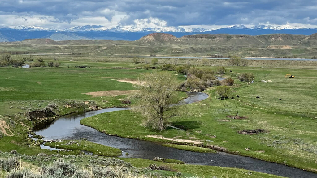
Lake Tahoe, pictured here, contains 37 trillion gallons of water, roughly half of which is supplied by snowmelt in the Sierra Nevada Mountains. Credit: Beatrice L. Gordon
Working at this scale, we found one-size-fits-all strategies often don’t hold up, even within the same hydrologic basin [Gordon et al., 2024; Boisramé et al., 2026]. In the Upper Colorado River Basin, for example, expanding reservoir storage could buffer agriculture in northeastern Utah against declining snowpack, but the same strategy may fail miles away in southwestern Wyoming, where a thirstier atmosphere may make it harder to refill existing reservoirs.
However, collecting detailed local-scale information for just 13 of the roughly 2,600 operational contexts nationwide took almost 3 years of searching websites, reading working papers, and calling water managers.
Scaling this approach across the entire western United States is understandably overwhelming. We need a more systematic approach to help managers identify which strategies could work most effectively, and where.
A Diagnostic for Agriculture and Snow Loss
Ostrom [2007] argued that complex systems, such as Western agriculture, “are partially decomposable in their structure.” This insight is woven into archetype analysis, an approach for identifying recurrent patterns across otherwise diverse systems.
Like workplace assessments—which are genuinely useful, albeit imperfect, tools for understanding successful management styles—archetypes draw on qualitative, quantitative, or hybrid approaches to group diverse operational contexts on the basis of shared characteristics [Sietz et al., 2019]. These groupings enable systematic knowledge transfer about, for example, how management strategies that work in one context can also guide adaptation elsewhere.
Three main characteristics interact to define operational contexts in snow-dependent agriculture in the western United States: physical constraints, governance systems, and human behavior.
“Researchers can empirically derive building blocks or components that comprise archetypes to represent key features of a system,” explains Elizabeth Koebele, who studies urban water sustainability [Garcia et al., 2019] and has begun applying archetypes in that context. However, she notes, these building blocks “vary based on the system context, available data, and study goal.”
We propose three main characteristics that interact to define operational contexts in snow-dependent agriculture in the western United States: physical constraints, governance systems, and human behavior. Physical constraints, including biophysical setting, infrastructure, and climate, determine available water supplies. Governance capacity relative to governance complexity shapes how those supplies are allocated across competing uses. Human behaviors influence both water demand and how users respond to supply conditions and governance rules.
Using these characteristics to establish archetypes of water management contexts could define a path forward for operationalizing an approach to accelerate successful adaptations to declining snowpacks in the West.
Constraining How Snowmelt Becomes Water Supply
Physical constraints stem from biophysical processes that influence how, when, and how much snow becomes streamflow; infrastructure that stores and conveys water; and hydrologic and climatic uncertainties about future supplies. These constraints can vary substantially from basin to basin.
Consider the Walker River Basin and California’s San Joaquin Valley, both of which rely on Sierra Nevada snowpack but have different biophysical settings. In some parts of the central Sierra, forest management can reduce wildfire risk and increase streamflow by up to 14% during low-snow years. Elsewhere, however, water made available by forest management may be consumed by remaining vegetation, limiting downstream gains.
These biophysical differences interact with uses of built infrastructure, including irrigation systems, reservoir outlets, and canals, to determine how and when water is stored and released. As temperatures warm and snowmelt declines, officials in both the Walker River and San Joaquin Valley basins must increasingly manage for a wider range of extremes, including “cold-water droughts.” However, the infrastructure to manage these trade-offs through reservoir storage and operations that balance agricultural deliveries with aquatic habitat needs is more developed in the highly managed San Joaquin than in the Walker.
Thankfully, measuring physical constraints on snowmelt at basin scales is becoming more feasible today with newly developed tools.
Layered on top of biophysical and infrastructural constraints are climatic and hydrological uncertainties, such as whether snow loss will lead to more evapotranspiration and less streamflow. These uncertainties complicate management decisions based on cost-benefit modeling of individual strategies: Should districts expand reservoir storage if precipitation is predicted to increase or decrease depending on the model? Frameworks like Decision Making Under Deep Uncertainty emphasize the need to select strategies that are robust across many possible futures.
Thankfully, measuring physical constraints on snowmelt at basin scales—a means, along with improved modeling, to reduce hydroclimatic uncertainties—is becoming more feasible today with newly developed tools. Water managers can turn, for example, to databases like the U.S. Geological Survey’s ResOpsUS [Steyaert et al., 2022], which catalogs historical reservoir operations across the contiguous United States, and to publicly available hydrologic projections such as those from Oak Ridge National Laboratory’s Coupled Models Intercomparison Project phase 6 (CMIP6) ensemble.
Governance Controls Supply Allocations
We frame governance around capacity and complexity. Capacity in this context is the ability of stakeholders “to mobilize resources in order to make equitable and fair decisions around shared challenges,” according to governance scholar Gina Gilson. Complexity refers to the number and intricacy of jurisdictions, authorities, regulations, and stakeholders involved. As governance complexity increases, the effectiveness of adaptation strategies becomes more sensitive to capacity constraints, particularly regarding timescales and funding.
For example, infrastructure in the Walker is controlled locally by a single water district, and jurisdictional coordination involves two states and the Walker River Paiute Tribe. Coordination on water management is never simple, but fewer jurisdictions generally means faster decisionmaking and clearer authority, allowing the single water district to implement strategies like multibenefit land repurposing more readily. Such implementations, in turn, enable reduced agricultural water use, directly supporting restoration of Walker Lake and recovery of endangered species.
The San Joaquin Valley is vastly different in scale and complexity, covering eight California counties, one of which alone has 22 water districts and seven cities. Following the passage of the state’s Sustainable Groundwater Management Act, water users in the basin formed more than 120 groundwater sustainability agencies. Agricultural water management thus involves overlapping federal and state systems that operate under different rules, contracts, and regulatory requirements. Whileland repurposing programs can be implemented, more substantial capacity, time, and resources are typically needed to do so.
Emerging efforts like the Western States Water Data Access and Analysis Tool (WestDAAT) and the Harmonized Database of Western U.S. Water Rights make it easier to assess governance in a basin by standardizing data about rules, regulations, and water rights across states. Combined with mapping of irrigation service areas and water transfers [Siddik et al., 2023], these resources help stakeholders identify the jurisdictions involved, how authority is distributed, and what coordination mechanisms exist for agricultural water management.
Human Behavior Shapes Demand Responses
Once snowmelt reaches water users, behavioral dynamics—how people respond to crises, policies, and changing conditions—determine how effectively management strategies achieve desired results.
Water demand is influenced by consumption choices and by economic, political, and cultural factors.
Water demand is influenced by consumption choices and by economic, political, and cultural factors. It is also influenced by factors that typical hydrologic models rarely account for, including social structure, social memory, and affluence. More affluent users are less likely to modify their behavior to reduce water use under conditions of scarcity.
The dynamics of water demand in the South Platte River Basin, for example, are especially complex, as they are balanced across cities, agriculture, and ecosystems across parts of Colorado, Nebraska, and Wyoming. Water prices in the basin’s Big Thompson project, a federal water diversion system in northern Colorado, jumped from $1,500 per acre-foot in 1990 to more than $30,000 in 2018, driven by economic factors that resulted in cities owning 70% of water originally intended for agriculture.
Even with reliable projections of future climate and water supply, carefully planned strategies can be overwhelmed by economic and behavioral factors, resulting in transfers and reallocations of water. What’s more, behavioral responses to adaptation strategies can paradoxically increase demand when users perceive that scarcity problems are solved.
The “reservoir effect” occurs when water security perceptions encourage expansion of water-intensive activities [Di Baldassarre et al., 2018]. Similarly, the irrigation efficiency paradox shows how efficiency gains can lead to expanded production and reduced return flows (how much irrigation water returns to streams and aquifers) downstream [Grafton et al., 2018].
Conceptual frameworks, models, and global case studies have all been used as approaches to study the effects of human behavior on hydrology. With sufficient training data, we believe tools like machine learning could be used to further explore how behaviors influence adaptation and to anticipate shifts as snow loss continues.
Archetypes in Practice
By evaluating how physical factors, governance systems, and human behavior shape outcomes across places like the Walker, South Platte, and San Joaquin basins, researchers and practitioners can establish archetypes to help identify patterns in what strategies are most effective in different places and assess how to transfer lessons from one setting to another (Figure 2).
Fig. 2. An archetype-based diagnostic grounded in evaluating the physical constraints, governance, and human behavioral dynamics affecting hydrologic basins could facilitate more rapid transfer of learning about successful adaptation approaches across snowmelt-dependent agriculture in the western United States.
The Walker River Basin exemplifies an archetype common to agriculturally dominated headwaters in the western United States with low governance complexity (few jurisdictions), adequate capacity (resources), low behavioral complexity (more predictable and unified user groups), and substantial physical constraints (significant future snow loss and limited infrastructure for water storage and supplementation).
With this profile, the Walker is an ideal testing ground for evaluating how effectively different strategies offset changes in snowmelt. Does cloud seeding increase snowpack? Could beaver dam analogues—a nature-based solution reminiscent of Idaho Fish and Game’s mid-20th century effort to parachute beavers into the wilderness—meaningfully increase water retention? Could multibenefit land repurposing buffer people and ecosystems against supply volatility while restoring ecosystem functionality?
The value of organizing operational contexts by archetypes is that each context need not be treated as unique.
The value of organizing operational contexts by archetypes is that each context need not be treated as unique. Lessons learned from the Walker could be systematically transferred to other areas with similar characteristics and could be incrementally tested in others.
The South Platte has physical constraints similar to Walker’s but features greater governance complexity because of multiple interstate compacts, as well as greater behavioral complexity. Modeling analyses indicate that demand-side strategies could adapt to more volatile water supply in the South Platte [Gharib et al., 2023]. But implementing them requires balancing perspectives from both agricultural and urban water users—a behavioral dynamic absent in Walker.
Crop switching to cultivate higher-value crops on less acreage could reduce water use. However, options for what crops can be grown where are constrained by factors like elevation and climate. Even where feasible, new crops would require investments in education, new infrastructure, risk management, and agronomic knowledge.
Through iterative expansion and testing, broad archetypes like “high behavioral complexity” could be specified to reflect dynamics like rural-urban competition or concerns around buy-and-dry economics. Archetypes may also point to contexts where governance complexity signals that decisionmaking is occurring above the lowest appropriate level.
The San Joaquin, with its extremely complex governance involving numerous local, state, and federal agencies managing surface and groundwater, is one potential example. Recognizing this pattern can help identify where substantial resources and long timelines may be required to implement programs (e.g., LandFlex) requiring legislative authorization, multiagency coordination, and stakeholder engagement. It may also signal the need to identify smaller operational contexts within larger settings so implementations proceed more rapidly.
Operationalizing Archetypes from Diagnosis to Action
Developing a systematic approach to match adaptation strategies with areas where they are most likely to succeed in operation is only a first step. Applying diagnostics without mechanisms to implement new strategies is often insufficient to drive timely action.
An instructive precedent of success in water quality management comes from the 1970s. By then, pollution controls on factories had improved compared with the early 20th century, yet water quality in surface waters across the country still declined because of pollution in agricultural runoff. The breakthrough came with the EPA’s total maximum daily load (TMDL) program, which created a structured process that set measurable goals for reducing pollution and assigned responsibility for meeting those goals to the sources of the pollution, allowing for local control over adaptation.
Archetypes could play a similar role in facilitating beneficial snow-loss adaptations, and a structure like the TMDL program could start by assessing supply-demand risks across operational areas, setting performance targets such as reservoir reliability and shortage frequency, and then using the diagnostic to identify which strategies fit each archetype. Results and lessons could be shared region-wide, while implementation would remain locally driven.
This suggestion is, emphatically, not a prescription for specific policy mechanisms. But it serves as a reminder that—just as few of us engage with workplace assessments or change behavior on the basis of their results without organizational support—archetypes will need to be paired with implementation structures to translate diagnosis into action.
Beyond Silver Bullets
There is no single answer to our trillion-dollar question, but one path forward for sustaining complex Western ecosystems lies in developing archetypes of different types of basins.
Nearly 20 years ago, Ostrom [2007] warned against seeking panaceas for complex environmental problems. There is no silver bullet for snow loss or single answer to our trillion-dollar question, but one path forward for sustaining complex Western ecosystems lies in developing archetypes of different types of basins.
A small irrigation district, for example, wouldn’t need to independently test every strategy in Figure 1 or develop complex decision support tools when a similar archetype already evaluated which strategies work under comparable governance, behavioral, and physical conditions.
Critically, these archetypes can be developed and refined by managers and scientists to capture more nuanced realities. Physically constrained systems, for example, could include areas facing high future uncertainty or limited reservoir flexibility. Governance and behavioral dimensions could likewise evolve to represent contexts where subsidies lead to incoherent incentives or where cultural norms link water use to local identities and traditions.
Like workplace assessments, the goal isn’t to diminish unique personalities but to work with them more strategically. Archetypes can show where we don’t need to reinvent the wheel to adapt and where the wheel might need to be tweaked. By leveraging collective knowledge and learning across regions facing similar challenges, rather than crafting new solutions basin by basin, we can reduce the time and resources needed to implement equitable and sustainable adaptation solutions.
Acknowledgments
This work is supported by the National Science Foundation (NSF) under grants 1828902 and OIA-2148788. Where We Live is funded by a grant from NSF’s Established Program to Stimulate Competitive Research (EPSCoR) RII Track-2 program and features partnerships across the University of Idaho (award 2316126); the University of Nevada, Reno (award 2316127); and the University of South Carolina (award 2316128). Work was also supported by internal funds from the Division of Hydrologic Resources at the Desert Research Institute.
References
Boisramé, G. F., et al. (2026), Think globally, model locally: Complex responses of agricultural water supplies to different climate projections, J. Am. Water Resour. Assoc., 62(3), e70117, https://doi.org/10.1111/1752-1688.70117.
Garcia, M., et al. (2019), Towards urban water sustainability: Analyzing management transitions in Miami, Las Vegas, and Los Angeles, Global Environ. Change, 58, 101967, https://doi.org/10.1016/j.gloenvcha.2019.101967.
Gharib, A. A., et al. (2023), Assessment of vulnerability to water shortage in semi-arid river basins: The value of demand reduction and storage capacity, Sci. Total Environ., 871, 161964, https://doi.org/10.1016/j.scitotenv.2023.161964.
Gordon, B. L., et al. (2024), The essential role of local context in shaping risk and risk reduction strategies for snowmelt‐dependent irrigated agriculture, Earth’s Future, 12(6), e2024EF004577, https://doi.org/10.1029/2024EF004577.
Ostrom, E. (2007), A diagnostic approach for going beyond panaceas, Proc. Natl. Acad. Sci. U. S. A., 104(39), 15,181–15,187, https://doi.org/10.1073/pnas.0702288104.
Sietz, D., et al. (2019), Archetype analysis in sustainability research: Methodological portfolio and analytical frontiers, Ecol. Soc., 24(3), 34, www.jstor.org/stable/26796999.
Steyaert, J. C., et al. (2022), ResOpsUS, a dataset of historical reservoir operations in the contiguous United States, Sci. Data, 9, 34, https://doi.org/10.1038/s41597-022-01134-7.
Sturm, M., et al. (2017), Water and life from snow: A trillion dollar science question, Water Resour. Res., 53(5), 3,534–3,544, https://doi.org/10.1002/2017WR020840.
Author Information
Beatrice L. Gordon (beatrice.gordon@dri.edu), Gabrielle F. S. Boisrame, Christine M. Albano, and Rosemary W. H. Carroll, Desert Research Institute, Reno, Nev.; and Adrian A. Harpold, University of Nevada, Reno
Citation: Gordon, B. L., G. F. S. Boisrame, C. M. Albano, R. W. H. Carroll, and A. A. Harpold (2026), Archetypes could accelerate agricultural adaptation to less snowpack, Eos, 107, https://doi.org/10.1029/2026EO260184. Published on 9 June 2026.
This article does not represent the opinion of AGU, Eos, or any of its affiliates. It is solely the opinion of the author(s).
Research & Developments is a blog for brief updates that provide context for the flurry of news that impacts science and scientists today.
In the contiguous United States, crop irrigation, municipal water supplies, and thermoelectric power generation use more than 224 billion gallons of fresh water every day. Conducting water research or making decisions about water use, until now, often required referencing datasets across various agencies. The U.S. Geological Survey (USGS) National
Research & Developments is a blog for brief updates that provide context for the flurry of news that impacts science and scientists today.
In the contiguous United States, crop irrigation, municipal water supplies, and thermoelectric power generation use more than 224 billion gallons of fresh water every day. Conducting water research or making decisions about water use, until now, often required referencing datasets across various agencies. The U.S. Geological Survey (USGS) National Water Availability Assessment Data Companion (NWDC), announced this week, aims to streamline this process. In part, the tool is designed to help decisionmakers better understand the balance between how high demand and limited supply affect water availability in their communities.
“While the United States has abundant water nationally, regional imbalances between supply and demand may create water challenges affecting millions of Americans,” said lead scientist Shirley Leung in a USGSpress release. “What once required significant resources and time can now be done in minutes, giving communities of all sizes the same foundation for water planning.”
The lower 48 states are home to about 80,000 sub-watersheds, from those in the arid southwest to the Great Lakes Basin, where about 84% of North America’s surface fresh water is located. According to the USGS, the NWDC is the first tool that integrates information about water availability in individual watersheds at a national scale.
The tool is designed to complement Water Data for the Nation (WDFN), another USGS product that consolidates observational data from the agency’s thousands of local monitoring stations gathering data on streams, lakes, reservoirs, precipitation, water quality, and groundwater. The new tool uses modeling to fill in spatial and temporal gaps between the observations made at these stations.
Water managers, researchers, agricultural experts, and others can use the NWDC to compare watershed conditions, identify seasonal patterns in water use, or to create data visualizations of statewide water use, for example. Though the tool currently covers only the contiguous United States, it will soon be extended to Alaska, Hawaii, and Puerto Rico, according to the USGS.
David Tarboton, a professor of civil engineering at the Utah Water Research Laboratory, said he was “intrigued” by the new tool, and is interested in examining the data its model produces.
While Tarboton was disappointed that the tool’s most recent available data are from 2020, “having a sort of integrated, wall-to-wall dataset that’s consistently produced is very valuable,” he said. He works, in part, in the areas of hydroinformatics and data sharing, and noted that the modern methods the agency is using to share the data could be useful in developing automated tools.
These updates are made possible through information from the scientific community. Do you have a story about science or scientists? Send us a tip at eos@agu.org.
From 1980 through 2024, the United States averaged 9 weather and climate disasters per year, each causing at least $1 billion in damage. Over the most recent five years, that average jumped to 23. The country is not facing the same weather it built its infrastructure to handle.
A new National Academies of Sciences, Engineering, and Medicine report, released May 19, 2026, argues that the way to absorb the coming climate shocks is to stop treating energy and water as separate research problems. Th
From 1980 through 2024, the United States averaged 9 weather and climate disasters per year, each causing at least $1 billion in damage. Over the most recent five years, that average jumped to 23. The country is not facing the same weather it built its infrastructure to handle.
A new National Academies of Sciences, Engineering, and Medicine report, released May 19, 2026, argues that the way to absorb the coming climate shocks is to stop treating energy and water as separate research problems. The report was commissioned by the U.S. Department of Energy to guide a proposed Regional Energy–Water Technology Pilot program and makes the case that severe weather, aging infrastructure, electrification, and the explosive growth of data centers have pushed the two systems to a point where failures in one cascade into the other.
Coordinated research across the water and energy infrastructure, the researchers say, is essential for reliability.
How Severe Weather Couples Two Systems Into One Failure Mode
Energy depends on water, and water depends on energy. While this sounds simple, the report shows that the connection between them has become fragile in reality.
Power plants use water for cooling. Hydropower releases water to make electricity. Drinking water systems need electricity to pump, treat, and pressurize water. Wastewater plants also need electricity to prevent pollution in rivers and bays. If any of these links break under stress, the problem spreads to the other systems.
The committee points to Winter Storm Uri in February 2021 as a key example. When ERCOT’s grid failed in Texas, it did more than leave millions without power. It also shut down water treatment and distribution, resulting in boil-water notices for millions of Texans, and left some communities without safe water for days. The report says events like this are likely to happen more often.
The mechanisms behind that expectation are documented across the rest of the report:
Thermal power vulnerability. From 2000 through 2015, 43 U.S. power plants reported shutdowns due to high water temperatures, most occurring during summer heat waves, drought, or both. Nuclear plants accounted for 25 of those shutdowns.
Future capacity losses. Modeling cited in the report projects that future water availability and rising temperatures will decrease U.S. national thermoelectric power capacity by an average of 2.5 percent, with individual plant impacts ranging from a 31 percent decrease to a 6 percent increase, depending on location.
Saltwater intrusion. In South Florida, sea-level rise combined with groundwater pumping is pushing saltwater into freshwater aquifers, forcing the use of energy-intensive reverse osmosis to produce drinking water. The climate impact becomes a permanent energy cost.
Wildfire feedback loops. Wind-driven contact between vegetation and overhead power lines sparks wildfires. Utilities respond with public safety power shutoffs. The shutoffs strain water systems that need electricity to maintain pressure. Firefighting depletes reservoirs. After the fire, runoff carrying combustion byproducts and damaged pipe materials degrades water quality for months.
Compound drought and heat. Drought and extreme heat now co-occur more often, simultaneously raising electricity demand for cooling and reducing water available for thermoelectric generation and hydropower. Each stress amplifies the other.
What the Report Recommends
The committee’s main recommendation is for the Department of Energy to create a group of regional pilot projects. Instead of single demonstrations, these would be coordinated investments to test how integrated energy–water solutions work in different parts of the country. For example, drought in the Southwest is very different from flooding in the Gulf Coast or grid failures during cold weather in the Plains.
Two recommendations focus on preparing for severe weather. Recommendation 2-3 says pilot projects should clearly consider the effects of possible extreme events. Recommendation 2-5 goes further by asking DOE to make proactive risk management at the energy–water intersection a main goal of the program. This includes investing in risk assessment, scenario planning, and early warning tools.
The committee is clear about what is at risk. Without careful scenario planning and investment in coordinated solutions, the report says that cascading failures will increasingly threaten economic stability, public health, environmental protection, and national security.
Why This Recommendation Is Vulnerable Right Now
The proposed pilot program falls under DOE’s Hydropower and Hydrokinetic Office, which was renamed from the Water Power Technologies Office in early 2026 and reorganized into the new Office of Critical Minerals and Energy Innovation. The office’s framing under the current administration emphasizes affordability, reliability, and energy dominance rather than climate adaptation.
This approach brings both an opportunity and a risk. The opportunity is that an energy–water pilot program can be supported for its reliability and economic benefits, without needing to rely on climate-change arguments to gain political support. The risk is that the climate-related research priorities identified by the National Academies committee could be left out of the program if no one outside DOE advocates for them.
It is difficult for research recommendations to carry their full weight when the supporting evidence is being defunded.
What You Can Do
Right now, public pressure on Congress and industry trade groups can influence whether the pilot program is funded, designed effectively, and focused on the climate-related risks described in the report. Here are some concrete actions, listed from most to least impactful:
Contact Your Members of Congress
Find your representatives. Use house.gov to find your House member by ZIP code, and senate.gov for your two senators.
Request three specific actions: full funding for the DOE Hydropower and Hydrokinetic Office’s regional energy–water pilot program in the next fiscal year; clear language in the appropriations report that directs the program to include the National Academies report’s Recommendations 2-3 and 2-5 on extreme-event risk; and restoration of federal funding for the NOAA billion-dollar disaster tracking and the climate and infrastructure data programs that researchers, utilities, and insurers rely on.
Make your message local. Members of Congress pay more attention to issues that affect their constituents directly. Mention the energy and water utilities in your area, recent disasters your region has faced, and the local economic impacts. A letter specific to your district is more effective than a general petition.
The report often points out that professional associations are some of the most trusted ways to move energy–water research from policy into real-world practice. Members of these groups can advocate for change from within.
If you work in or with a water utility, ask whether your utility is engaging with the American Water Works Association’s Water 2050 initiative and its sustainability and resilience strategic priority. Urge utility leadership to file public comment in support of the DOE pilot program through AWWA’s federal advocacy channels.
If you are a utility customer, remember that public utility commissions and city councils decide water and electric rates and approve investments in resilience. Speaking up at resource planning hearings is one of the few times residents can directly influence how utilities prepare for severe weather. Support the Research and Data Infrastructure
Defend the data. Climate Central’s takeover of the billion-dollar disasters database is useful but does not substitute for the federal data infrastructure that utilities, insurers, and grid operators depend on. Write to your representatives in support of restoring NOAA’s climate and weather data programs in the next appropriations cycle.
Use and reference the report. The National Academies report is free to download. If you work in planning, journalism, policy, or research, its approach to viewing energy-sheds alongside watersheds offers a helpful perspective that can influence local decisions.
Pay attention to your state’s utility regulators. State public utility commissions are now key places where decisions about resilience investments for extreme events are made. Their meetings are open to the public, their decisions depend on public comments, and they often do not get the attention they deserve considering the money they manage.
The National Academies committee chose its words carefully when talking about climate change. While the word climate appears often, the report focuses on risk, extreme events, changing conditions, and resilience in uncertain times. No matter what language is used in future funding debates, the facts remain: heat waves and droughts are happening more often and together, hurricanes are getting stronger faster, wildfires are starting earlier and burning larger, and the country’s energy and water infrastructure was built for a climate that is now gone.
The report is valuable because it goes beyond just describing the problem. It offers a specific federal solution: a regional pilot program at DOE that can help close the gap. Whether this program is created as the committee intended will partly depend on how many people push for it.