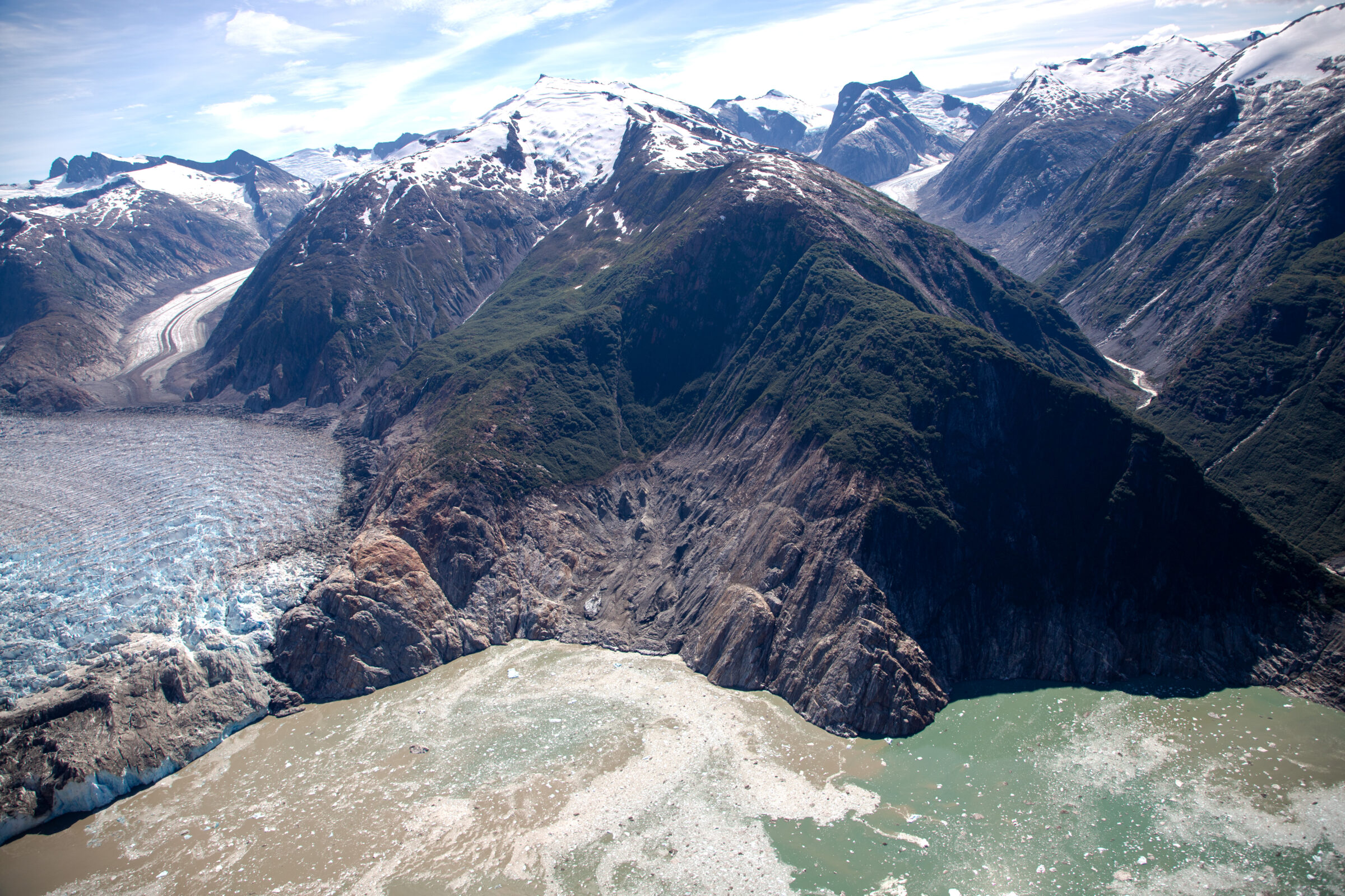
As glaciers retreat in warming regions, the risk of related hazards can increase, and improved monitoring may help reduce some of those dangers, according to a new study.
As glaciers retreat in warming regions, the risk of related hazards can increase, and improved monitoring may help reduce some of those dangers, according to a new study.
The economy of Peru’s Sacred Valley has long been entwined with the seasons. Rural communities typically grow crops and raise livestock to sustain themselves and to barter with others, a process that necessitates an attunement with nature, its cycles, and how these patterns influence self-sufficiency.
This is particularly true for the Quechua communities, Indigenous peoples who have long worked for subsistence rather than state currencies. In recent years, health clinics, schools, markets,
The economy of Peru’s Sacred Valley has long been entwined with the seasons. Rural communities typically grow crops and raise livestock to sustain themselves and to barter with others, a process that necessitates an attunement with nature, its cycles, and how these patterns influence self-sufficiency.
This is particularly true for the Quechua communities, Indigenous peoples who have long worked for subsistence rather than state currencies. In recent years, health clinics, schools, markets, and transportation requiring residents to use cash have slowly eroded this way of life. Today, many Quechua men leave their communities to work in tourism, which offers an income and the opportunity to learn Spanish. Conversely, women often remain at home to care for children and farms, making them dependent on support from their partners and family members.
In 2009, the nonprofit Awamaki formed to aid communities around Ollantaytambo, Cusco, as they navigated this change. U.S.-based Kennedy Leavens and Miguel Galdo, of Peru, had worked together previously at a similar organization supporting 10 women weavers from Patacancha. When that project shuddered, the two decided to found Awamaki to maintain their support.
The nonprofit grew quickly, and today, it assists nine cooperatives, comprising 174 artisans and community members who work across craft and tourism. With collaboration at its core, Awamaki prides itself on sustainability and focuses on broadening its partners’ access to a diverse array of markets and economic opportunities.
In addition to financial changes, the climate crisis is rapidly transforming the ways of the Sacred Valley, which faces disproportionate impacts as glaciers melt and the water supply dwindles. “The shift towards having personal income, for our artisan partners, is not about replacing traditional livelihoods, but about widening the economic ground beneath them so they can move their families towards prosperity and build resiliency to the effects of climate change, all without leaving the community or traditional ways of life,” the nonprofit tells us.
Partnering with Awamaki allows cooperative members to focus on traditional spinning, dyeing, and weaving traditions, while the nonprofit offers structural support in selling their goods and coordinating tourism. Carving through the terrain north of Cusco, the Andean highlands were once home to the Incans and still hold traces of the ancient empire, like the historic city of Machu Picchu, which continues to attract around one million people from around the globe each year. For many years, the organization says, visitors would arrive in villages without prior notice, and the women would halt their work to meet tourists and hopefully, sell a piece.
And of course, this way of making is demanding, as women not only weave, but also raise alpacas, shear their wool, and spin and dye the soft fibers into yarn. “Before weaving, I have to wash my hands carefully so the wool doesn’t get damaged. It requires attention and care,” Ricardina, an Awamaki member from the Cusci Qoyllur cooperative, tells us. “Sometimes I can weave more, sometimes less. It depends on time, on my children, on everything else I have to do.”
Today, Awamaki helps to coordinate tourism and provide compensation for visits. This includes programs like Murmur Ring’s immersion, which will bring a group of creatives to the region this June. “Our role is to create opportunities that can be compatible with cultural continuity, if that is what communities themselves want,” they say, adding:
For women, without personal income, everyday decisions can feel distant. Paying for school supplies, buying medicine, covering transportation costs, buying food to supplement the limited traditional crops that grow at high altitude–all of these depend on uncertain flows of money and shifting household dynamics. As climate patterns grow more erratic, with harsher frosts, longer dry spells, and thinning pasture, even the agricultural base families rely on has become less predictable, deepening that sense of financial fragility.
This regular support has simultaneously buoyed many women to greater financial independence and helped retain their way of life. “When new artisans join a cooperative, they are typically mentored by other women in their own community. Cultural knowledge remains community-held and community-led,” the nonprofit shares.
“In my family, we make decisions together—about how to earn and how to move forward,” Daniela, a weaver from the Puskariy Tika cooperative, says. “Through this work, we are able to keep going and improve our lives little by little.”
Nadia, of the Rumia cooperative, echoes this sentiment. “Being part of Awamaki changed things for us. Now we have a steady income, and that allows us to keep weaving,” she says. “In our community, it’s not always easy. Some people say, ‘Why do you weave?’ But they don’t understand this work… We also teach our children to care for the environment, to grow things, to respect the land. That’s part of our work, too.”
To learn more about the women and support their work, visit Awamaki’s website.
Source: Earth’s Future
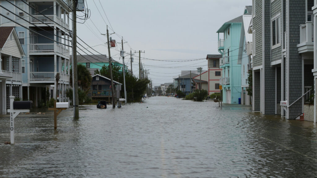
Coastal landscapes are constantly being reshaped by natural forces, and as climate change causes more frequent storms and sea level rise, that change will only intensify. Because these areas are densely populated with homes, tourist destinations, and industries, understanding how and where the coast will change is a pressing issue. However, reliable predictions that lead to actionable knowledge are rare.
Lentz et al. describe the state of knowledge regarding coastal
Coastal landscapes are constantly being reshaped by natural forces, and as climate change causes more frequent storms and sea level rise, that change will only intensify. Because these areas are densely populated with homes, tourist destinations, and industries, understanding how and where the coast will change is a pressing issue. However, reliable predictions that lead to actionable knowledge are rare.
Lentz et al. describe the state of knowledge regarding coastal evolution, highlight gaps in scientists’ understanding, and describe opportunities for integrating information from various models, data sources, and end users.
Current coastal evolution predictions are often focused on too specific a location and are therefore hard to generalize or analyze too large a region and therefore lack detail, the authors say. In addition, it’s challenging for researchers to link the effects of acute events, such as storms, with long-term trends like sea level rise.
Improving these simulations will likely require combining many different types of models, including physics-based numerical models, models based on empirical measurements, and statistical models that include machine learning. To fully understand potential changes, the authors note that it is also essential to consider both coastal processes and human actions.
The researchers recommend several ways to improve consistency and collaboration in the field of coastal change forecasting. First, standardizing approaches and outcomes would make it easier to produce national-scale predictions. Right now, the variety of tools used across different locations makes it difficult for scientists to compare results and communicate effectively. They also emphasize the need for using coordinated research approaches. Stronger transdisciplinary collaboration, accompanied by essential training and support, would also enable scientists to make better predictions, the researchers say.
Comparing predictions to real-world observations of coastal landscape change could also help untangle this multifaceted challenge. By studying how coastlines have already changed, researchers can validate models and choose those that are performing best. Such comparisons require datasets that adequately capture coastal landscape change across both time and space. Remote sensing data and the use of artificial intelligence (AI) for data processing may help provide these improved datasets, the researchers suggest.
Engaging end users during the project planning process is also helpful because only end users truly know what kind of information they need to adapt to landscape change. Knowing how to engage end users can be difficult for physical scientists, but various tools and specialized personnel exist who can help coordinate these interactions, the authors say. (Earth’s Future, https://doi.org/10.1029/2024EF005833, 2026)
At a recent Climate School event, speaker Memphis Washington discussed the Waterfront Alliance's climate resilience and environmental justice efforts in Coney Island.
At a recent Climate School event, speaker Memphis Washington discussed the Waterfront Alliance's climate resilience and environmental justice efforts in Coney Island.
Known for his stunning photos of wildlife and landscapes, as well as co-founding SeaLegacy alongside fellow conservationist and photographer Cristina Mittermeier, Paul Nicklen has traveled the globe to not only highlight our planet’s phenomenal biodiversity but also to shed light on its increasing vulnerabilities due to the ongoing climate crisis.
Nicklen’s most ambitious project yet gathers myriad images from a career exploring the corners of the earth for more than three decades. Forthco
Known for his stunning photos of wildlife and landscapes, as well as co-founding SeaLegacy alongside fellow conservationist and photographer Cristina Mittermeier, Paul Nicklen has traveled the globe to not only highlight our planet’s phenomenal biodiversity but also to shed light on its increasing vulnerabilities due to the ongoing climate crisis.
Nicklen’s most ambitious project yet gathers myriad images from a career exploring the corners of the earth for more than three decades. Forthcoming from Hemeria, Reverence marks the most comprehensive collection of his work to date. The book features 160 photographs, including some of Nicklen’s most enduring images alongside others previously unpublished.
From the root-like system of the Colorado River delta to narwhals feeding on cod in the Arctic Bay off Baffin Island, Nicklen’s photos illuminate the vast and resilient beauty of the natural world. “Reverence is what we feel in the silent presence of a whale beneath the ice, in the fierce gaze of a polar bear, in the timeless dance of ocean and light,” says a statement. “It is what the natural world evokes when we stop long enough to truly see it.”
Reverence is slated for release on July 28, which is also World Conservation Day, and pre-orders are open now.
Editors’ Highlights are summaries of recent papers by AGU’s journal editors.
Source: Journal of Geophysical Research: Atmospheres
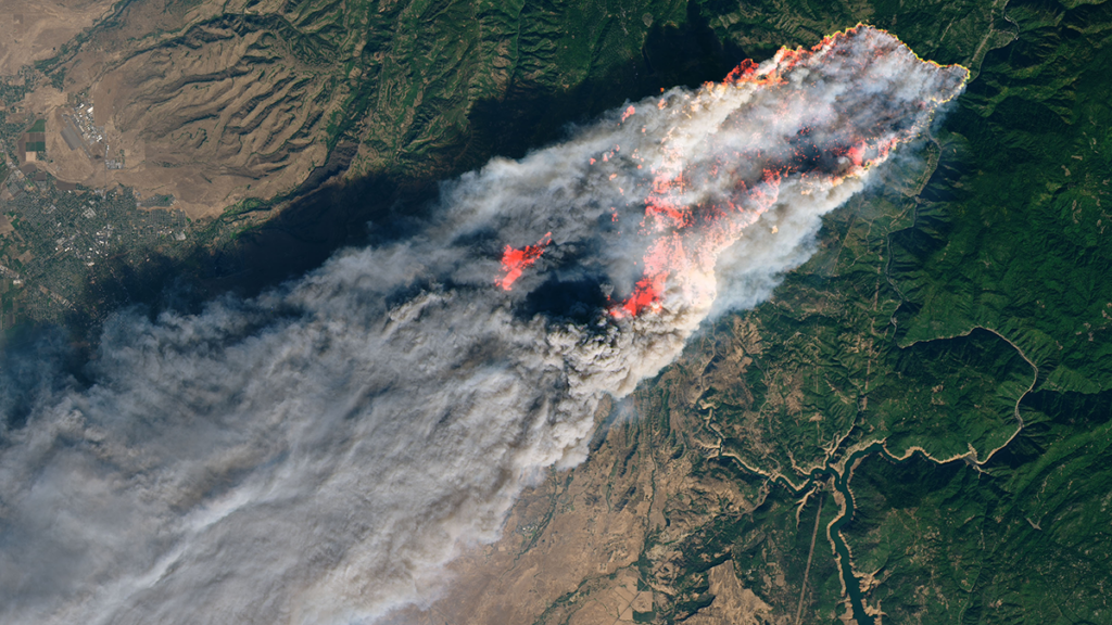
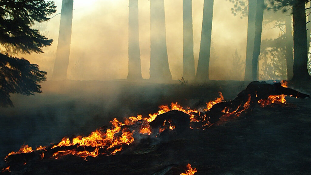
The 2018 Camp Fire was the deadliest and most destructive wildfire in California history. The Camp Fire spread extremely rapidly, driven by strong winds and dry fuels, but also by organized long-range spotting, i.e. lofting and downwind fallout of burning embers to ignite new fires.
Using operational Doppler radar and satellite observations, Lareau [2026] pr
Source: Journal of Geophysical Research: Atmospheres
The 2018 Camp Fire was the deadliest and most destructive wildfire in California history. The Camp Fire spread extremely rapidly, driven by strong winds and dry fuels, but also by organized long-range spotting, i.e. lofting and downwind fallout of burning embers to ignite new fires.
Using operational Doppler radar and satellite observations, Lareau [2026] provides the first high resolution depiction of spotting behavior during an extreme wildfire. Observations show that spot fire events for the Camp Fire occurred 5-10 kilometers ahead of the fire front, quickly merging into new fire lines. Spot fires are not random but aligned within coherent fallout zones that are shaped by plume dynamics and background winds. These results show that operational weather radar can identify lofting and fallout regions in real time, providing a new way to anticipate spotting-driven fire spread and improve early warnings for fast-moving wildfires.
(a) Along wind cross section of Camp Fire plume reflectivity observed by radar measurements, showing distinct updrafts (white arrows) and ashfall regions (blue dashed arrow). Spot fires within 10 minutes of these radar measurements are shown as filled cyan triangles. (b) Map of column maximum radar reflectivity and fire perimeter. In both panels the black dashed line indicates the eastern edge of the town of Paradise, California. Credit: Lareau [2026], Figure 6ab
Citation: Lareau, N. P. (2026). Plume-coupled long-range spotting drove the explosive spread of the 2018 Camp Fire. Journal of Geophysical Research: Atmospheres, 131, e2025JD045798. https://doi.org/10.1029/2025JD045798
Source: AGU Advances
Across the western United States, wildfires are increasing in size and intensity. As the climate continues to warm, more extreme wildfires will reshape landscapes and pose a growing risk to human health and natural ecosystems throughout the West.
Climate models, used to predict other effects of climate change, are unable to directly simulate wildfires. Instead, researchers link previously burned areas to climate variables such as temperature, precipitation, drought, a
Across the western United States, wildfires are increasing in size and intensity. As the climate continues to warm, more extreme wildfires will reshape landscapes and pose a growing risk to human health and natural ecosystems throughout the West.
Climate models, used to predict other effects of climate change, are unable to directly simulate wildfires. Instead, researchers link previously burned areas to climate variables such as temperature, precipitation, drought, and evaporation, then apply those relationships to future climate projections.
Many recent studies have connected higher vapor pressure deficit (VPD)—a measure of atmospheric dryness—to more area burned in previous fires. VPD increases as the temperature rises, so models that rely on it generally predict an increase in wildfire activity as the climate warms.
Cheng et al. raise questions about the role VPD plays in modeling wildfire, suggesting that VPD is a poor measure of fuel dryness at larger scales and overestimates potential burned areas under significant warming conditions. Instead, researchers suggest soil moisture could be a more reliable indicator of fuel dryness and lead to more moderate projections of wildfire increases.
The researchers looked at five forested ecoregions in the western states. Using the Western US MTBS-Interagency wildfire dataset from 1984 to 2020 combined with climate data (temperature, VPD, and soil moisture), the researchers analyzed drivers of the area burned from May through October. They connected this information with output from climate models to look at future burn potential.
VPD-based wildfire predictions increase sharply under warming conditions. These predictions showed that under 3°C of average global warming, 16 times as much land would burn by the end of the century, compared to historical levels. Under 4°C of warming, up to 66 times more land would burn by the end of the century. This “truly massive” increase, the authors say, would mean fires consuming vegetation almost as soon as it regrows.
Soil moisture, on the other hand, provides a more moderate, though still concerning, picture. Under the same warming scenarios, soil moisture changes would lead to an increase in burned area of only 2–3 times that of the historical period. The researchers argue that projections relying on VPD severely exaggerate wildfire risk. (AGU Advances, https://doi.org/10.1029/2026AV002350, 2026)
Citation: Owen, R. (2026), How much will western wildfires worsen under warming?, Eos, 107, https://doi.org/10.1029/2026EO260147. Published on 15 May 2026.
The NYC Mid-Winter Climate Institute brought together K-12 educators to identify meaningful entry points for climate education lessons in their classrooms and beyond.
The NYC Mid-Winter Climate Institute brought together K-12 educators to identify meaningful entry points for climate education lessons in their classrooms and beyond.
Scientists agree that to have a chance of keeping the world’s warming below the Paris Agreement limit of 1.5°C (2.7°F), humanity needs most oil, gas, and coal to remain in the ground. This “unburnable” or “unextractable” carbon would not contribute to global carbon emissions.
But where, exactly, should we prioritize shutting down or banning fossil fuel activities? A new study published in PLoS One provides an answer for the Arctic with an atlas showing where oil and gas activities overlap wi
Scientists agree that to have a chance of keeping the world’s warming below the Paris Agreement limit of 1.5°C (2.7°F), humanity needs most oil, gas, and coal to remain in the ground. This “unburnable” or “unextractable” carbon would not contribute to global carbon emissions.
But where, exactly, should we prioritize shutting down or banning fossil fuel activities? A new study published in PLoS One provides an answer for the Arctic with an atlas showing where oil and gas activities overlap with vulnerable ecosystems, important wildlife species, and Indigenous land.
“We’re investigating the idea of unburnable carbon with a geographical perspective,” said Daniele Codato, a geographer at the Università de Padova in Italy and lead author of the new study. “We focus on where to keep oil and gas underground.”
The atlas is meant to help decisionmakers prioritize areas where it is essential to avoid opening new frontiers or where current oil and gas extraction should be halted because of social, cultural, ecological, or climate justice criteria, he said.
Overlaps, Mapped
Codato and a team of researchers created their Arctic atlas with dozens of public datasets from five Arctic polities known to have oil and gas activities (Alaska (United States), Canada, Greenland (Denmark), Norway, and Russia). Though various geographic definitions of the Arctic exist, the team chose a boundary used to evaluate wildlife and conservation by the Conservation of Arctic Flora and Fauna (the biodiversity working group of the Arctic Council, an intergovernmental organization focused on Arctic governance) to include the largest possible portion of vulnerable ecosystems.
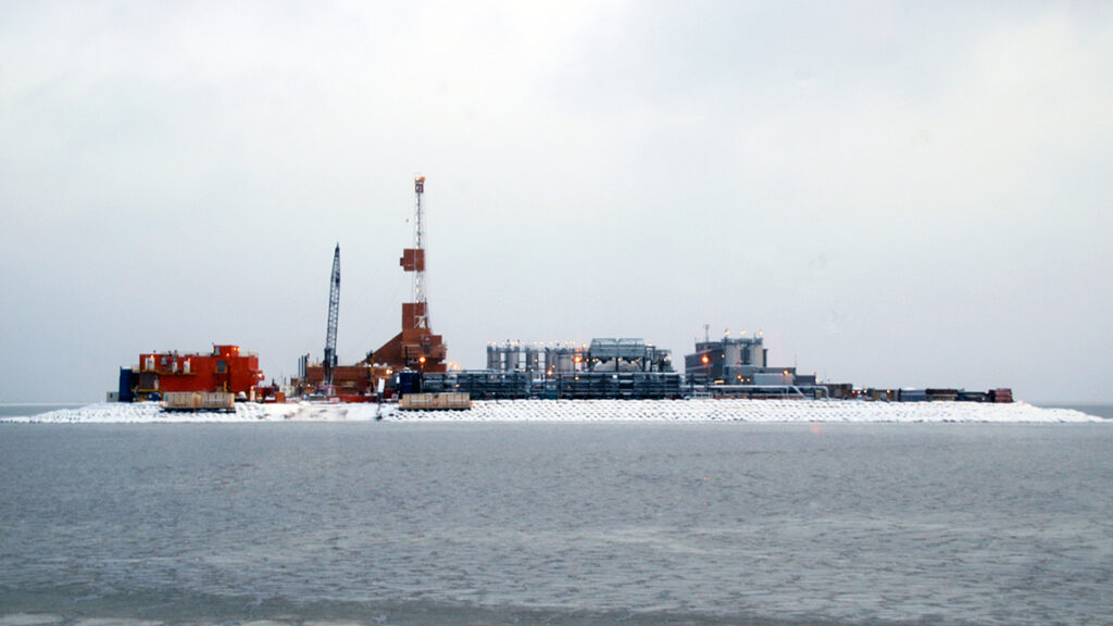
The resulting maps revealed more than 512,000 square kilometers—an area about the size of Spain—of Arctic territory with existing or planned fossil fuel activities, including leases, areas under bid, exploration licenses, and infrastructure. Within those areas, the researchers counted 44,539 active wells and nearly 40,000 kilometers (about 25,000 miles) of pipelines.
Oil and gas wells in the Arctic are highly concentrated in northwestern Canada, northern Alaska, and northern Russia. The CAFF boundary identifies the Arctic region as defined by the Conservation of Arctic Flora and Fauna (the biodiversity working group of the Arctic Council). Click image for larger version. Credit: Codato et al., 2026, https://doi.org/10.1371/journal.pone.0345775
Next, the researchers determined how oil and gas activities overlapped with protected areas defined by the International Union for Conservation of Nature and conservation priority areas defined by three other nongovernmental organizations. Fossil fuel activities threaten wildlife by altering habitats, disrupting migratory routes, and releasing pollutants.
Of the area containing oil and gas activities, more than 7% overlapped with ecologically protected areas, and more than 13% overlapped with the ranges of all of the three key Arctic species considered in the study: polar bears, yellow-billed loons, and caribou. The highest concentrations of oil and gas activities were in the Yamal Peninsula of Russia, northwestern Canada, and the North Slope of Alaska, all home to fragile ecosystems.
Seven percent of Arctic fossil fuel extraction areas mapped by the research team overlapped with ecologically protected areas. In some cases, such as in the Yamal`skij Nature Reserve in Russia (top right), protected area borders have been cut or delimited to avoid overlapping with protected area boundaries, possibly indicating that protected areas have been downsized or redesigned to accommodate fossil fuel infrastructure. ANWR = Arctic National Wildlife Refuge. Click image for larger version. Credit: Codato et al., 2026, https://doi.org/10.1371/journal.pone.0345775
Mapping revealed that 87.21% of leases in Alaska and more than 13% of total Arctic concessions for fossil fuel activities overlapped with the ranges of all three of the key Arctic species considered in the study (polar bears (Ursus maritimus), caribou (Rangifer tarandus), and yellow-billed loons (Gavia adamsii)). Click image for larger version. Credit: Codato et al., 2026, https://doi.org/10.1371/journal.pone.0345775
The researchers also discovered that 73% of land with oil and gas activities overlapped with Indigenous Peoples’ lands, defined in the study as lands where Indigenous communities maintain significant influence over land management. Fossil fuel activities can threaten Indigenous communities’ health and ways of life, though the authors note that overlaps between Indigenous Peoples’ lands and fossil fuel activities do not necessarily indicate an opposition between the two.
Oil and gas concessions cover more than 4% of Indigenous Peoples’ lands (IPLs) in the Arctic. Click image for larger version. Credit: Codato et al., 2026, https://doi.org/10.1371/journal.pone.0345775
“It’s a really interesting idea to create an atlas of unburnable carbon and try to make visible where tensions might occur between Indigenous land, ecosystems, [and fossil fuel activities],” said Mariel Kieval, a researcher at the Arctic Institute, a nonprofit research organization. The overlaps noted in the atlas are an “initial indicator” providing opportunities for further research that zooms in on specific areas, she said.
Kieval also said the atlas could be helpful for local communities trying to identify where extraction activities are occurring nearby.
Policy Paradigm
The atlas’s effort to express the urgency of action to the public and policymakers is useful, said Paul Ekins, an economist at University College London who was part of the team that coined the term “unburnable carbon.” “Any way in which atlases or discussions or slogans can up the political ante so that politicians become braver in seeking to address this issue is to be welcomed.”
In particular, Codato hopes the atlas will fuel a “paradigm shift” in global policy that would ultimately ban the proliferation of fossil fuel activities in the Arctic.
The need for an intergovernmental ban on fossil fuel activities is evidenced by the Arctic National Wildlife Refuge in Alaska, Codato said: The refuge received temporary protections against drilling under the Biden administration, but the Trump administration plans to open the refuge for oil and gas leases this summer. “We need something stronger” to avoid such administration-by-administration changes in Arctic protections, he said.
“If we don’t start to ban fossil fuels in the Arctic now, it could become another sacrifice zone.”
Such a paradigm shift will be more important than ever as warming in the Arctic provides new access to resources and opportunities for trade that may accelerate ecological and cultural disruptions. “If we don’t start to ban fossil fuels in the Arctic now, it could become another sacrifice zone,” like some parts of the Amazon rainforest, Codato said.
Policy actions have fallen far behind the science, Ekins said. “There should have been an agreement not to exploit fossil fuels in the Arctic well before the ice had melted to a sufficient extent to make that a practical possibility.”
In 2023, the research team published a similar atlas identifying unburnable carbon in the Ecuadorian Amazon and plans to continue to expand their atlas to include the rest of the world. The team is currently working on projects that cover Brazil, Italy, Nigeria, and the United Kingdom.
Citation: van Deelen, G. (2026), This Arctic atlas shows where oil and gas activities overlap with wildlife and Indigenous communities, Eos, 107, https://doi.org/10.1029/2026EO260139. Published on 7 May 2026.
Research & Developments is a blog for brief updates that provide context for the flurry of news that impacts science and scientists today.
Human-driven climate change is driving the rise of sea levels, worsening flood conditions and threatening coastal communities around the world. Not only is sea level rising, but it’s rising faster every year. Understanding the degree to which different processes contribute to sea level, known as the sea level budget, can help scientists better pre
Research & Developments is a blog for brief updates that provide context for the flurry of news that impacts science and scientists today.
Human-driven climate change is driving the rise of sea levels, worsening flood conditions and threatening coastal communities around the world. Not only is sea level rising, but it’s rising faster every year. Understanding the degree to which different processes contribute to sea level, known as the sea level budget, can help scientists better predict where and how quickly sea level will rise under potential climate futures.
But for several decades there has been a “budget gap” between measurements of sea level change and the total estimated contributions from glaciers, polar ice, land storage, and oceans expanding as they heat up (thermospheric expansion). Research published today in Science Advances has helped close that budget gap by incorporating more recent sea level observations, reconciling measurements taken by different instruments, and including recent community estimates of sea level rise and its components.
The new analysis breaks down the drivers of sea level rise from 1960 to 2023. The team found that the largest contributor is heat-driven expansion of seawater, responsible for 43% of sea level rise since 1960. Melting ice contributed the next largest amount of sea level rise: 27% came from mountain glaciers, while 15% came from the Greenland Ice Sheet and 12% from the Antarctic Ice Sheet. Lastly, sea level rose 3% as land reduced its capacity to store water.
Since 1960, 43% of global sea level rise can be attributed to thermal expansion of water, just 3% to a reduction in land water storage, and the remainder from melting ice and glaciers. Credit: Zheng et al., Science Advances (2026)
“For years, there has been a frustrating gap between how much the oceans were observed to be rising and how much we could explain from the individual causes,” John Abraham, an engineer at the University of St. Thomas in St Paul, Minn., and a coauthor on the new research, said in a press release. “This work shows that, with better instruments, processes, and smarter analysis, this knowledge gap can be closed. We can explain sea level rise with greater confidence.”
The researchers also calculated the rate at which sea level has risen since 1960 and how each component factored in. They found that the rate of sea level rise has recently doubled: It was 2 millimeters per year averaged over 1960–2023 and 4 millimeters per year averaged over just 2005–2023. The strongest driver of that doubling is ocean warming, responsible for 41% of the accelerating rate of sea level rise, followed by reduced land water storage (21%).
In the past, glacial melt was the largest contributor to sea level rise before it was overtaken by thermospheric ocean expansion overtook (left). The rate of sea level rise has been speeding up since about 1980, also driven by thermospheric ocean expansion (right). Credit: Zheng et al., Science Advances (2026)
This research demonstrates the importance of maintaining detailed records of sea level rise, collecting new measurements, and not backing away from global change research. With better data on which processes contribute to sea level rise and its acceleration, policymakers and local communities can create informed mitigation strategies that account for future rise.
These updates are made possible through information from the scientific community. Do you have a story about science or scientists? Send us a tip at eos@agu.org.
A Malaise trap we set up in Prospect Park in a small native meadow near Dog Beach. | Benji Jones/Vox
New York City is one of the most well-explored places on Earth.
Established nearly four centuries ago by an influential Dutchman, the city has since grown into the largest and most densely populated metropolis in the country, with no fewer than 28,000 people per square mile, or about one person per 1,000 square feet. People are everywhere.
That’s what makes this so astonishing: Scienti
A Malaise trap we set up in Prospect Park in a small native meadow near Dog Beach. | Benji Jones/Vox
New York City is one of the most well-explored places on Earth.
Established nearly four centuries ago by an influential Dutchman, the city has since grown into the largest and most densely populated metropolis in the country, with no fewer than 28,000 people per square mile, or about one person per 1,000 square feet. People are everywhere.
That’s what makes this so astonishing: Scientists believe there are almost certainly hundreds, if not thousands, of undiscovered animal species living in the middle of New York, among the city’s parks, gardens, and streets. I’m not talking about the big stuff — birds, frogs, and so on — but small critters, including flies, wasps, and other insects.
It’s not that NYC is some sort of global bug hot spot. (Despite what it might feel like in the summer, it is not.) Rather, the bulk of species in many insect groups, wherever they’re found, remains unknown. As one example, there may be as many as 1.8 million species globally in a single fly family called Cecidomyiidae, known as the gall midges. Yet only about 7,000 of them have been described in the scientific record and are thus known species. Broadly speaking, taxonomists estimate that as much as 90 percent of all animal species on Earth are still unknown. That is, of course, nearly all of them.
This summer, Vox is setting out to play a small role in filling these giant gaps in the global tree of life — by trying to discover a new species, right here in New York. It’s a goal we understand to be both attainable and useful: Documenting the world’s biodiversity is essential to any argument and effort to protect it. And to be clear, protecting insects is among the most self-serving acts humans can partake in, given the role bugs play in pollinating our foods, cleaning up our feces, and feeding other wildlife.
In both Central Park and Prospect Park, we’ve deployed a tent-like structure called a Malaise trap to capture small flying insects, including flies and parasitoid wasps — the latter a vastly understudied group of wasps that lay their eggs in other insects. Bugs that fly into the trap are funneled into a jar of ethanol, where they’re killed and preserved. The traps are designed to capture only small flying critters, and usually do not entrap things like dragonflies, butterflies, and spiders.
Will this process harm insects?
Malaise traps are a common sampling tool to assess the diversity of flying insects like flies and wasps. They don’t use scent lures or other attractants but rather intercept bugs as they’re moving through the environment.
The trap does kill small insects that fly into it — those that are less than about a quarter in size — but overall the impact on their populations is minor, according to Emily Hartop, an entomologist at the Norwegian University of Science and Technology who’s involved in the project. Insect populations are orders of magnitude larger than what the trap will collect. And in fact, Hartop says, it’s Malaise trapping that’s helped reveal the global decline in insects.
The traps we’re using are also designed to filter out larger critters including butterflies and dragonflies, and we’ll monitor them throughout the summer to make sure that is indeed the case.
The traps will be open and collecting insects for three summer months: June, July, and August.
Step 2: Sequence their DNA
Every month or so, we’ll send the insects we collect in the city to a lab in Canada called the Centre for Biodiversity Genomics (CBG). There, scientists will begin to sequence small fragments of their genomes, producing distinct, genetic “barcodes” for each of them. These barcodes are unique genetic IDs that help differentiate one species from another.
Once CBG scientists have barcodes for our NYC insects, they can then compare those IDs to the millions of barcodes for animals in North America and around the world that researchers have already sequenced. It’s sort of like running fingerprints from a crime scene through an FBI database to identify a suspect. If there’s no match — meaning, there’s no record for animals with those same genetic IDs — that will indicate that what we found may be new.
Step 3: Bring in the expert taxonomists
If genetic sequencing turns up bugs with unique, matchless codes, CBG will send those specimens to the entomologists who know them best, for a more thorough analysis. For example, Emily Hartop, a taxonomist at the Norwegian University of Science and Technology who’s helping lead the project, is a global expert in scuttle flies; we’ll send potentially new scuttle flies to her. Meanwhile, Ranjith AP, a taxonomist at CBG, will review any potentially new wasps in the families Braconidae and Ichneumonidae. Should genetic sequencing turn up any potentially new bees, we’ll send those to the American Museum of Natural History for examination.
The job of Hartop, AP, and other taxonomists is to take a closer look at the specimens’ genetic codes and anatomies, and review records for similar species that have already been described (those that are named in the scientific literature). Should that process also fail to surface a match — with any already-described species — that means what we have is new.
Step 4: Give the species a name
The next and final (and admittedly most exciting) step is to publish a description of the species, including evidence of its novelty, along with a name, in an academic journal, such as Zootaxa. That will make the new species official by adding it to the formal scientific record.
What will we name a new species, should we be lucky enough to discover one? We remain open to suggestions.
Ultimately, a project of this size is not going to make a noticeable dent in describing life on Earth, perhaps not even life in NYC. What we hope it will do is reveal the scale of the unknown and at a time when the planet is losing so much. Many insect groups are declining, including important pollinators like bees, wasps, and butterflies. And that means that unless we ramp up the rate of discovery, we will almost certainly lose species to extinction before we even know they exist, let alone what they do and why they’re important.
As the global sustainable forestry industry grows, driven by a carbon credit market expected to reach US$19.9 trillion by 2035, long-term conservation projects in Latin American countries like Peru are taking off.
The Slalom Foundation – part of the global digital consulting firm Slalom – operated a fund of over US$10 million and recently awarded more than $200,000 to impact initiatives in Latin America, Africa, and the U.S.
Among those receiving the fresh Slalom Foundation funds is the Fores
As the global sustainable forestry industry grows, driven by a carbon credit market expected to reach US$19.9 trillion by 2035, long-term conservation projects in Latin American countries like Peru are taking off.
The Slalom Foundation – part of the global digital consulting firm Slalom – operated a fund of over US$10 million and recently awarded more than $200,000 to impact initiatives in Latin America, Africa, and the U.S.
Among those receiving the fresh Slalom Foundation funds is the Forest Stewardship Council Investments & Partnerships (FSC). The FSC has been working with the Peruvian National Service of Natural Protected Areas (SERNANP) to certify 7.4 million hectares of national parks and Peruvian Amazon ecosystems.
Through its Certification Initiative, the FSC has set up shop in Peru, recently announcing a brand new conservation facility, which will streamline the certification process of national parks and conservation areas in the country.
The FSC Certification Initiative has already committed US$1.7 million in 2026 to high-value areas in Africa, Latin America, and Central Asia. As it seeks new partners to scale impact, it welcomes Slalom Foundation’s donation and funding for Peru.
“We are profoundly honored to receive the climatic subsidy from the Slalom Foundation in support of the Fund for Conservation of the FSC,” said Jen Opie, deputy executive director of FSC Investments & Partnerships. “This investment accelerates our certifying capabilities to protect some of the most critical conservation areas in the world throughout Latin America, including Peru.”
Today, sustainable forestry and conservation efforts are tied to the global carbon credit offsetting market.
A Precedence Research report released in February estimated that the global carbon credit market is worth US$1.3 trillion and expected to grow to $19.9 trillion by 2035, expanding at a CAGR of 35.80% in the same period.
While North America is expected to see the fastest growth, and Europe holds the largest share of the market, Latin America stands out for its untapped potential, as sectors like aviation and big tech — seeking to offset new energy-hungry AI data center operations – drive demand.
Within this market, forestry conservation projects lead the way.
The Slalom Foundation said that the organizations benefiting from their recent investment are setting in motion groundbreaking conservation and ecological programs, helping families and women access essential services, and promoting technological certifications that support local wealth and economic development.
“These environments often face significant barriers when trying to access the necessary resources to unblock financing for long term conservation,” said Opie from FSC. “The collaboration with Slalom reinforces our shared commitment to safeguarding biodiversity, promoting climate resilience, and supporting local communities, whose stewardship is essential to global climate goals,” she added.
“Together, we are scaling credible and verifiable nature-based climate solutions at a time when decisive action has never been more urgent,” concluded Opie.
Featured image description: Aerial view of the Amazon Rainforest.
Featured image credit: FSC.
Disclosure: This article mentions a client of an Espacio portfolio company.