In November 2025, Cyclone Senyar generated extreme rainfall in parts of Sumatra, Indonesia, triggering thousands of landslides. Our new paper in the journal Current Biology demonstrates that these landslides might have a devastating impact on a critically endangered population of Tapanuli orangutan.
In November 2025, Cyclone Senyar brought extreme rainfall to large parts of Sumatra in Indonesia. I have written about this on previous occasions – the rainfall triggered vast numbers of lan
In November 2025, Cyclone Senyar generated extreme rainfall in parts of Sumatra, Indonesia, triggering thousands of landslides. Our new paper in the journal Current Biology demonstrates that these landslides might have a devastating impact on a critically endangered population of Tapanuli orangutan.
In my line of work, we often focus on the landslide impacts on the landscape, on human lives and on infrastructure. We rarely consider the impacts on th eanimal population. This is certainly a weakness that the Cyclone Senyar event brings to focus.
Part of the area devastated by the landslides is that slopes around the Batang Toru rover, an area of forest that is home to a rare species of orangutang. These great apes, Pongo tapanuliensis, live in a habitat known as the West Block of Tapanuli. There are only 800 individuals left in the wild, a situation that is highly precarious. The loss of even a small number of adults could tip the species towards extinction.
I was a part of a consortium of scientists that considered the landslide impacts of Cyclone Senyar on the habitat of these orangutangs. The results have just been published in the journal Current Biology (Meijaard et al. 2026) – the paper is open access and published under a creative commons license.
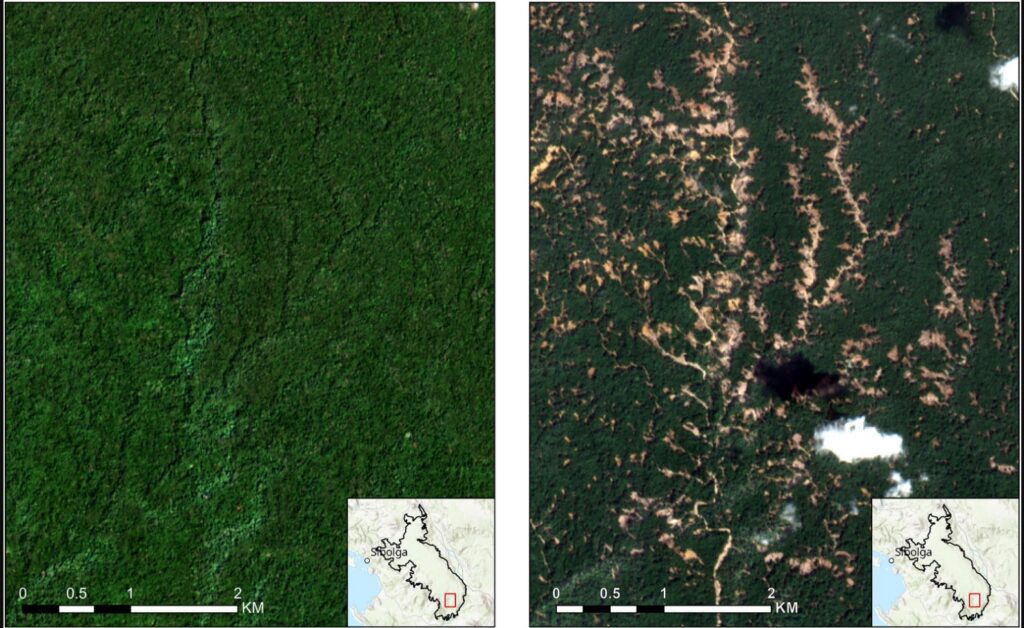
This image, from the paper, shows the landslide impacts of Cyclone Senyar:-
Before and after satellite imagery of the impacts of Cyclone Senyar. From: Meijaard et al. (2026).
In the study area of 71,161 hectares, the mapping indicates that there were 50, 185 individual landslides, covering a surface area of 8,303 hectares. This is about 11% of the forested area. We then estimate the likely loss of the orangutang population, which is likely to be in the range of 18-120 individuals, with a central estimate of 58 individuals. This is likely to have been a devastating loss for this highly endangered population.
This level of habitat loss might also be placing a severe pressure on the remaining population, so further fatalities are very possible through, for example, reduced food availability.
The intensity of the rainfall was almost certainly supercharged by climate change. The impacts of Cyclone Senyar are being replicated widely – and of course we are now in the northern hemisphere tropical cyclone season again.
Our paper makes some policy recommendations for this population of orangutans. First, the government of Indonesia needs to permanently protect this area of forest against mining , palm oil and hydropower developments. Ideally, the protected area should be expanded. Second, Indonesia needs support for biodiversity-recovery, hazard forecasting and ecological restoration planning.
At one point, the Pacific Northwest lost three square miles of old-growth forest every week to clearcutting. Now, the Trump administration is returning to this practice.
In February 2026, the Bureau of Land Management (BLM) proposed changes to management plans for nearly 2.5 million acres of Oregon forests. The goal is to increase timber production fourfold and remove protections for old-growth forests and the endangered species that rely on them.
This proposal comes at a time when science is re
At one point, the Pacific Northwest lost three square miles of old-growth forest every week to clearcutting. Now, the Trump administration is returning to this practice.
In February 2026, the Bureau of Land Management (BLM) proposed changes to management plans for nearly 2.5 million acres of Oregon forests. The goal is to increase timber production fourfold and remove protections for old-growth forests and the endangered species that rely on them.
This proposal comes at a time when science is revealing even more about the importance of these forests. They are some of the best carbon-storing ecosystems on Earth, vital reservoirs of biodiversity, and essential for the communities nearby. If lost, they cannot be replaced within any human lifetime.
What Is an Old-Growth Forest?
Researchers first used the term in the 1970s to describe complex, biodiverse forests at least 150 years old. Still, there is no single definition for “old growth.” In the U.S., a federal rule protects trees over 21 inches in diameter in six national forests, where most old-growth forests are found. Many environmentalists define old growth as any forest that has never been logged. All definitions focus on complexity: old-growth forests have layered canopies, fallen logs in different stages of decay, and an understory full of fungi, ferns, and centuries of stored soil carbon.
In western Oregon, this complexity shows in Douglas fir and western red cedar trees that grow up to 200 feet tall, covered in moss so thick it hides their trunks. Even today, these forests are among the most productive timberlands in the world.
The Carbon Case, Revised and Strengthened
It was once believed that only young forests accumulated carbon while old forests merely stored it. Scientists now know that is wrong. A landmark global analysis of 519 forest carbon-flux estimates found that in forests aged 15 to 800 years, net carbon balance is usually positive. Old forests keep sequestering — they are not neutral.
A 2024 study in AGU Advances compared old-growth forests in the Pacific Northwest to younger managed forests. It found that old-growth forests produce more biomass for each unit of water used, keep storing carbon even as they age, and are much more resilient to drought than replanted forests. This resilience is especially important as Oregon faces hotter, drier summers, making the drought-buffering ability of old-growth forests just as valuable as their carbon storage.
A 2025 study in Science of the Total Environment found that mature and old-growth forests are better than younger forests at tackling both climate change and biodiversity loss at the same time. Plantations and second-growth timber stands cannot match these benefits.
The numbers show that cutting down old-growth trees is a bad idea. Bev Law, professor emerita at Oregon State University, told reporters that bringing BLM harvests back to 1 billion board feet a year, as the Trump administration aimed for in 2019, would be “insanity.” These forests can live for thousands of years. The carbon stored in their wood and soil stays out of the atmosphere and keeps building up over time.
Oregon Becomes a Battleground
The main threat from the Administration is focused on western Oregon’s O&C Lands. These lands, once granted to the Oregon and California Railroad, were returned to federal ownership in 1916 and now cover about 2.5 million acres across 17 counties managed by the BLM. In the 1960s, annual timber harvests often topped 1 billion board feet, reaching a peak of 1.638 billion in 1964. Harvests dropped sharply in the 1990s after the northern spotted owl and marbled murrelet were listed as threatened, and the Northwest Forest Plan shifted management toward conservation.
In February 2026, Trump’s BLM announced plans to revise management for these lands, aiming to bring timber production back to pre-1990 clear-cutting levels. The proposal covers all 2.5 million acres across 17 counties, including well-known areas such as the Sandy River watershed, North Fork Clackamas, the Valley of the Giants, the Upper Molalla River, and Alsea Falls. Since 2000, harvests have ranged from 45 to 275 million board feet per year. The new plan would raise that to 1 billion board feet.
The public comment period closed March 23, 2026; a record of decision is tentatively scheduled for February 12, 2027. That timeline could outlast the current administration, but the proposal, once formally proposed, would constrain future management options. The idea is to strip away environmental protections for salmon and drinking water and fire and fuels to maximize timber extraction across public lands in western Oregon, said George Sexton, conservation director for KS Wild.
The Roadless Rule and the Bigger Picture
The BLM proposal is part of a larger rollback. In August 2025, USDA Secretary Brooke Rollins announced that the Trump administration plans to end the 2001 Roadless Rule. This Clinton-era rule bans road building, logging, and mining on about 58 million acres of federal forest land, including 2 million acres in Oregon. Rollins described the rule as burdensome, outdated, and one-size-fits-all.
Environmental groups immediately promised litigation. “If the Trump administration actually revokes the roadless rule, we will see them in court,” said Earthjustice attorney Drew Caputo. Oregon Rep. Andrea Salinas introduced the Roadless Area Conservation Act in June 2025 to codify the rule into law, drawing nearly 50 House cosponsors.
In early 2025, Trump signed two executive orders telling agencies to speed up timber sales and avoid environmental reviews for more than 400 threatened and endangered species, such as wild salmon, marbled murrelets, and spotted owls. A Republican budget bill passed in the Senate also required the Forest Service to increase timber production by at least 250 million board feet each year and to sign 20-year logging contracts, regardless of the environmental impact.
Worth More Standing
There is a real economic case for logging, but it has limits. Many Oregon counties have struggled financially since logging declined in the 1990s, and timber revenue is important for rural budgets. However, industry representatives admit that most mills can no longer handle large old-growth logs. Technology now focuses on smaller and medium-sized wood, according to Amanda Sullivan-Astor of the Associated Oregon Loggers. The economic setup for harvesting old-growth trees is missing, even before considering legal challenges that could delay any plans for years.
The value of old-growth forests goes far beyond timber, and this is not reflected in timber prices. These forests support a huge variety of life, including not just spotted owls and murrelets, but also salmon, elk, bears, rare fungi, and plants that cannot survive even in plantations of the same species. Old-growth forests help manage water, protect drinking supplies, prevent erosion and landslides, and shield nearby communities from wildfires. This is the opposite of what the BLM claims clearcutting would do. In fact, the BLM’s own research has shown that clearcutting old-growth rainforests actually increases fire risk.
The fungal networks under the forest floor are getting more attention from scientists and in popular books. These networks add another layer of complexity that cannot be replaced. Scientists are still learning how trees use these fungal connections to share nutrients and chemical signals over many years. These systems take centuries to form and cannot be recreated in plantations.
Any unknown benefits that old-growth forests might offer will be lost forever, all for about $1,000 per centuries-old tree, the current price for old-growth timber.
What You Can Do
The BLM’s process for revising O&C Lands management is still ongoing. Although the public comment period ended in March 2026, the Environmental Impact Statement process is still underway, and legal challenges are almost certain. Here are some ways you can stay involved:
Contact your federal representatives about the Roadless Area Conservation Act and urge them to cosponsor legislation making the Roadless Rule permanent law.
Support the Old-Growth Forest Network, which works to designate protected native forests in every county in the U.S.
Visit and spend time in public lands. Your presence and spending as a visitor help show the value of forests beyond timber, which is important for land use planning.
If you live in a county with O&C Lands, go to local commissioner meetings where timber revenue is being discussed. While logging does bring in money, there are also strong financial reasons to keep forests intact, protect clean water, and support outdoor tourism.
Source: Earth’s Future
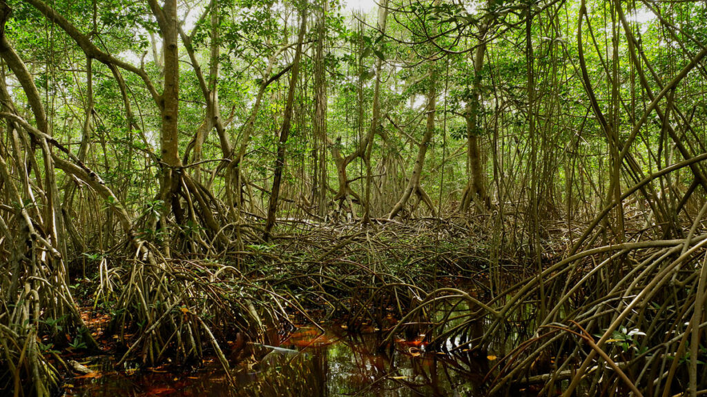
Mangrove forests straddle the edge of land and sea along some tropical and subtropical coastlines. These trees and shrubs have distinctive tangles of roots that trap sediment and produce organic matter, forming dense soils and efficiently storing carbon. Though mangroves cover only 1% of Earth’s surface, they store a whopping 15% of global ocean carbon in their trapped soils.
Their location along coastlines means mangroves are at the mercy of changing sea levels and
Mangrove forests straddle the edge of land and sea along some tropical and subtropical coastlines. These trees and shrubs have distinctive tangles of roots that trap sediment and produce organic matter, forming dense soils and efficiently storing carbon. Though mangroves cover only 1% of Earth’s surface, they store a whopping 15% of global ocean carbon in their trapped soils.
Their location along coastlines means mangroves are at the mercy of changing sea levels and sediment availability. Rising sea levels can drown mangroves or push them landward. At the same time, sediment supplies, belowground root growth, and organic matter accumulation can help build up mangrove soils, allowing forests to keep pace with sea level rise. So over time, will mangroves keep locking carbon into their soils, or will they start losing it?
Iwantoro et al. created a new model that examines the links between coastal processes to investigate vegetation growth and carbon accumulation in mangrove forests.
The researchers modeled a simplified tidal embayment to explore how different rates of sea level rise and sediment supplies would affect the mangroves. In these experiments, they found that carbon accumulation can increase at specific locations as waters rise because the increased water can lead to more mangrove growth—a result that matches existing data. However, when looking at landscape scales, they found sea level rise generally reduces total carbon sequestration through mangrove loss and soil erosion. The results showed that rising sea levels can alter mangroves from carbon storage sinks to carbon emitters.
The findings demonstrate that local trends in carbon sequestration may not be representative of larger-scale outcomes in mangrove forests. The study shows that understanding coastal landscapes as an interconnected system is crucial to understanding how mangroves can respond to climate and human-induced pressures, the researchers say. However, new assessments and approaches are needed to better understand future mangrove vulnerabilities. (Earth’s Future, https://doi.org/10.1029/2025EF006984, 2026)
Citation: Derouin, S. (2026), Mangroves may be losing their grip on carbon storage as sea levels rise, Eos, 107, https://doi.org/10.1029/2026EO260144. Published on 5 June 2026.
Known for his stunning photos of wildlife and landscapes, as well as co-founding SeaLegacy alongside fellow conservationist and photographer Cristina Mittermeier, Paul Nicklen has traveled the globe to not only highlight our planet’s phenomenal biodiversity but also to shed light on its increasing vulnerabilities due to the ongoing climate crisis.
Nicklen’s most ambitious project yet gathers myriad images from a career exploring the corners of the earth for more than three decades. Forthco
Known for his stunning photos of wildlife and landscapes, as well as co-founding SeaLegacy alongside fellow conservationist and photographer Cristina Mittermeier, Paul Nicklen has traveled the globe to not only highlight our planet’s phenomenal biodiversity but also to shed light on its increasing vulnerabilities due to the ongoing climate crisis.
Nicklen’s most ambitious project yet gathers myriad images from a career exploring the corners of the earth for more than three decades. Forthcoming from Hemeria, Reverence marks the most comprehensive collection of his work to date. The book features 160 photographs, including some of Nicklen’s most enduring images alongside others previously unpublished.
From the root-like system of the Colorado River delta to narwhals feeding on cod in the Arctic Bay off Baffin Island, Nicklen’s photos illuminate the vast and resilient beauty of the natural world. “Reverence is what we feel in the silent presence of a whale beneath the ice, in the fierce gaze of a polar bear, in the timeless dance of ocean and light,” says a statement. “It is what the natural world evokes when we stop long enough to truly see it.”
Reverence is slated for release on July 28, which is also World Conservation Day, and pre-orders are open now.
Planting more trees will decelerate climate change only if those trees are placed in optimal locations—primarily the tropics and subtropics—suggests new research published in Communications Earth and Environment. However, planting trees in locations like Alaska, Siberia, and large parts of the United States could actually lead to warming, said lead author and doctoral student at ETH Zurich Nora Fahrenbach.
Much of the current thinking in nature-based solutions, Fahrenbach said, is ba
Planting more trees will decelerate climate change only if those trees are placed in optimal locations—primarily the tropics and subtropics—suggests new research published in Communications Earth and Environment. However, planting trees in locations like Alaska, Siberia, and large parts of the United States could actually lead to warming, said lead author and doctoral student at ETH Zurich Nora Fahrenbach.
Much of the current thinking in nature-based solutions, Fahrenbach said, is based on the idea that “more is better.”
As in, “we’ll plant a trillion trees, or we’ll plant more than a trillion trees, and we are going to get more cooling, right?” Fahrenbach said. “That’s something we show is just not the case.”
Fahrenbach researches reforestation potentials, or global maps that identify areas where trees could be planted to mitigate climate change. In this work, she and her colleagues compared three prominent reforestation potentials to determine the effect of tree placement on local and global temperatures.
One scenario involved reforesting about 926 million hectares focused mostly on the tropics and resulted in about 0.25°C of cooling by 2100. Another called for reforesting 894 million hectares, including large areas in northern temperate and polar latitudes, and resulted in 0.13°C of cooling by 2100.
The third scenario involved planting forests strategically over only 440 million hectares of mostly tropical and subtropical land (less than half of the area covered in the other scenarios) but also resulted in 0.13°C of cooling. Geography, the findings suggest, may matter more than quantity when it comes to the cooling benefits of reforestation efforts.
Let’s Get (Biogeo)physical
The researchers modeled all three scenarios using the same parameters: Trees were planted from 2015 to 2070 and then remained steady in their population until 2100.
Planting trees in one area doesn’t just change the local temperature but has effects across the world.
All three models identified reforestation opportunities in regions such as the eastern United States, Amazonia, the Congo rainforest, and eastern China, as well as regions for which reforestation would not be as impactful, such as polar regions in the Northern Hemisphere. The researchers also found significant temperature changes across the Atlantic and Indian oceans as a result of atmospheric changes induced by reforestation, demonstrating an interconnected reality: Planting trees in one area doesn’t just change the local temperature but has effects across the world.
These local and nonlocal effects can be explained by a combination of biogeochemical and biogeophysical effects.
A biogeochemical effect relates to the movement of chemicals or chemical elements, such as trees absorbing carbon from the atmosphere.
A biogeophysical effect relates to the physical results of changing the land’s surface: Placing a tree in a snowy region, for instance, decreases the land’s albedo, meaning it causes the land surface to become darker and absorb more light, leading to more local heat. This rise in surface temperature also raises air temperature, creating cascading effects on wind patterns and oceanic currents.
Considering both processes together is essential for understanding whether a net cooling or net heating effect exists, but most policies focus only on biogeochemical effects, seeing trees solely for their ability to absorb carbon from the atmosphere, Fahrenbach said. They include prominent international policies such as the Paris Agreement and the United Nations’ Framework for REDD+.
“Really, we would also need to consider the biogeophysical effects,” Fahrenbach said. “That’s harder to do, right, considering those nonlocal effects, because just imagine, some country is going to plant a lot of trees, and that’s going to lead to warming somewhere else.”
A Call to Policymakers
Emilio Vilanova, a forest ecologist at the climate action nonprofit Verra, wrote by email, “The most important message for me is that this study emphasizes something that is often not well addressed in reforestation projects: Reforestation is not just about planting trees—it’s about designing where new forests go to maximize benefits and avoid unintended consequences.”
“Reforestation is a helpful tool, not a stand-alone solution to climate change.”
Vilanova also said the study puts the potential for reforestation efforts to address climate change in perspective. “Even very large reforestation efforts would only reduce global temperatures by about 0.13–0.25°C by the end of the century,” he said. “While meaningful, this finding also reinforces that reforestation is a helpful tool, not a stand-alone solution to climate change.”
Though the limited potential for change is sobering, the authors and Vilanova pointed out that this change does matter and that it matters how we think of our approach. They advocate for policies that adopt reforestation strategies based on location and that acknowledge both the local and nonlocal effects of reforestation.
“We really need to make sure that where we plant first, it has benefits locally, it has benefits globally,” Fahrenbach said.
22 April 2026: This article was updated to correct Nora Fahrenbach’s position at ETH Zurich.
This news article is included in our ENGAGE resource for educators seeking science news for their classroom lessons. Browse all ENGAGE articles, and share with your fellow educators how you integrated the article into an activity in the comments section below.
Citation: Meissen, A. (2026), Location, location, location: The “where” of reforestation may matter more than the extent, Eos, 107, https://doi.org/10.1029/2026EO260125. Published on 22 April 2026.
A new paper Fidan et al. (2026) demonstrates that wealth and the rate of land-cover change play a key role in determining the occurrence of fatal landslides in mountain areas. These factors are statistically more significant that precipitation and topography.
A fascinating new paper (Fidan et al. 2026 – this paper is both open access and published under a Creative Commons licence – hurrah!) has just been published in the journal Science Advances that explores rates of land-cover (in the
A new paper Fidan et al. (2026) demonstrates that wealth and the rate of land-cover change play a key role in determining the occurrence of fatal landslides in mountain areas. These factors are statistically more significant that precipitation and topography.
A fascinating new paper (Fidan et al. 2026 – this paper is both open access and published under a Creative Commons licence – hurrah!) has just been published in the journal Science Advances that explores rates of land-cover (in the paper, the authors use the term land-use – land-cover) change as a factor in determining fatal landslides in mountains globally. I must admit to some degree of personal interest in this paper, although I am neither an autor nor a reviewer, as it brilliantly uses the dataset that Melanie Froude and I collated on global landslide fatalities (see Froude and Petley 2018). I’m delighted to see our data being used in this way (and please do contact me if you want a copy of the spreadsheet).
Fidan et al. (2026) explores a range of factors that might influence the occurrence of fatal landslides from the perspective of either increased vulnerability (poorer people may live in more vulnerable locations for example) or increased landslide likelihood (land-cover change might increase the likelihood of a landslide being triggered, for example).
The fascinating result lies in land-cover change. The authors have looked at approximately 60 years of land-cover changes in mountainous areas across 46 countries. Unsurprisingly, there is substantial change, especially in low- and lower-middle–income countries, often involving the loss of forest (which as a first order estimation, may buffer against slope failures), although the pattern is far more complex of course. Fidan et al. (2026) find that a key metric is the rate of change of land-cover, and that this is linked to the rate of population growth (perhaps unsurprisingly). Countries with high rates of population growth also show high rates of change of land-cover.
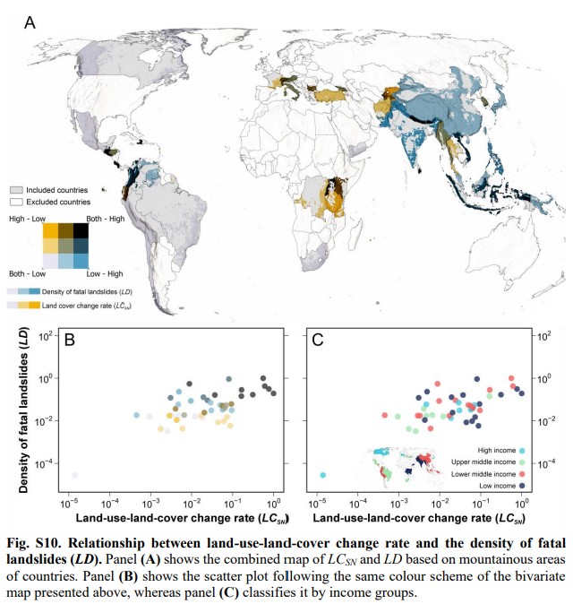
In many ways, the most interesting figure in this study is in the Supplementary Information. It is a complex diagram, but it’s worth more detailed analysis:-
The relationship between the land-cover change rate and the density of fatal landslides for mountain areas around the world. Figure from Fidan et al. (2026), published under a Creative Commons Licence.
The main map (A) shows mountain areas with high rates of land-cover change (orange), high density of fatal landslides (blue) or both (black). The left hand graph (B) shows the relationship between the landslide density and the rate of change of land-cover – here, higher rates of land-cover change are associated with a higher density of fatal landslides. The right hand graph is the same data as in (B), but with each point coloured according to the income level of the country. High income countries have a lower fatal landslide density. Thus, as the authors conclude, wealth and land-cover change appear to control fatal landslide density.
There is a really surprising element to this study, which I think requires more consideration. I think I should allow the authors themselves to express this finding, from the abstract:-
“Our statistical analyses show that land-use – land-cover changes have a substantially greater influence on the density of fatal landslides and landslide fatalities than physical factors such as topography and precipitation, especially in lower-income countries.”
As landslide researchers, we almost always default to topography and precipitation as being key in landslide occurrence. There are sound reasons for doing so. But statistically, the rate of land-cover change plays a more important role in mountain areas, especially in poorer countries.
This has (or should have) major implications for the way that we consider and manage landslide risk in such areas.
Photosynthesis does not always result in wood growth, a key factor in carbon dioxide sequestrationTrees may not be able to store as much planet-heating carbon as hoped, a study suggests, with researchers finding photosynthesis does not always lead to wood growth.Scientists studied 137 sites across the US and found trees stopped growing months before the point in the year at which photosynthesis stopped. Continue reading...
Photosynthesis does not always result in wood growth, a key factor in carbon dioxide sequestration
Trees may not be able to store as much planet-heating carbon as hoped, a study suggests, with researchers finding photosynthesis does not always lead to wood growth.
Scientists studied 137 sites across the US and found trees stopped growing months before the point in the year at which photosynthesis stopped.
Source: Earth’s Future
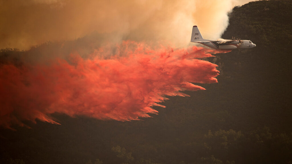
Hotter, drier conditions in the western United States have led to a rise in wildfire activity that has damaged or destroyed infrastructure, natural ecosystems, and entire towns across the region. As fires grow larger and more destructive, the cost of managing them rises as well.
Fire management agencies in the United States have been feeling the pressure. Between 2014 and 2023, fire management agencies across all levels of government experienced a 131% increase in t
Hotter, drier conditions in the western United States have led to a rise in wildfire activity that has damaged or destroyed infrastructure, natural ecosystems, and entire towns across the region. As fires grow larger and more destructive, the cost of managing them rises as well.
Fire management agencies in the United States have been feeling the pressure. Between 2014 and 2023, fire management agencies across all levels of government experienced a 131% increase in total area burned and a 268% increase in total fire spending adjusted for inflation compared to the period between 1985 and 1994.
Today, federal agencies like the Department of the Interior (DOI) and the U.S. Department of Agriculture Forest Service (USFS) continue to invest in aiding states and managing hazardous fuel growth on public land, as well as suppressing active fires. Policymakers and federal agencies alike must decide how to manage limited budgets while protecting people, property, and natural resources.
Prestemon et al. built statistical models based on historical data to examine the potential increase in spending by the DOI and the USFS between now and 2100. Their models link wildfire activity to climate variables such as temperature and water vapor deficit and then connect fire activity to suppression costs. To capture a range of possible future conditions on federal lands, the study predicts 10 fire and suppression spending scenarios by applying five different climate models to two different warming pathways (the moderate Representative Concentration Pathways (RCP) 4.5 scenario and the high-emissions RCP 8.5 scenario).
The results varied by region and scenario, but each of the 10 scenarios suggested a rise in area burned as well as inflation-adjusted fire suppression spending, with higher fire activity translating to higher costs. Projected changes in DOI and USFS land burned increased 80% by mid-century and 208% by late century.
By the middle of the century, both agencies are projected to see spending increases: about 0.65% per year for DOI spending and about 0.87% per year for USFS spending from 2020 to 2100. Although uncertainty increased with time and outcomes varied across climate models and warming pathways, the largest increases in both cost and wildfire activity were consistently projected for the northwestern United States. (Earth’s Future, https://doi.org/10.1029/2025EF007985, 2026).
Citation: Owen, R. (2026), As wildfires increase in the West, so does suppression spending, Eos, 107, https://doi.org/10.1029/2026EO260187. Published on 10 June 2026.