How do you determine how many months or years animal mothers nurse their babies? If you’re not in a rush and can observe this dynamic, you could supposedly stick around to see when the baby, mother, or both decide that they’re done. However, that could take years. A team of researchers investigating breastfeeding in orangutans recently opted for a different, perhaps surprising strategy—searching for particular proteins in poop.
In a preliminary study published in the journal Communications B
How do you determine how many months or years animal mothers nurse their babies? If you’re not in a rush and can observe this dynamic, you could supposedly stick around to see when the baby, mother, or both decide that they’re done. However, that could take years. A team of researchers investigating breastfeeding in orangutans recently opted for a different, perhaps surprising strategy—searching for particular proteins in poop.
In a preliminary study published in the journal Communications Biology, researchers searched for milk‑specific proteins in the feces of wild Bornean orangutans (Pongo pygmaeus) living in the Danum Valley Conservation Area, in the Malaysian part of the island of Borneo. These proteins prove that he or she is continuing to drink breast milk.The practice of recognizing particular proteins in feces is called fecal proteomics and it can help scientists better understand what animals are consuming.
“Orangutans have a slow life history with one of the longest interbirth intervals and the lowest reported infant mortality rates among primates or even mammals,” the team wrote in the study. “Breastfeeding is a key factor in their life history because it possibly promotes offspring health and increases maternal interbirth intervals.”
The team gathered fecal samples for over two and a half years, and found milk‑specific proteins in all the 20 samples from orangutans less than six and a half years old. This indicates that the young great apes were continuing to breastfeed until they were at least that age.
According to the team, these results are “consistent with the behavioral evidence as having one of the longest breastfeeding periods in mammals.”
What’s more, “milk intake was significantly correlated with higher levels of biological defense and probiotic bacterial proteins.”
In other words, the more milk a young orangutan drinks, the more probiotic intestinal bacteria it has and the sturdier its biological protections are. Such consistent and enduring breastfeeding probably helps the very high survival of orangutan babies and plays a role in their slow reproductive approach.
Unfortunately, Bornean orangutans are critically endangered, and the paper highlights why their populations don’t rebound quickly after a decrease. Safeguarding what’s left of their rainforest habitats is crucial.
This story was produced by Grist and the Food & Environment Reporting Network, a nonprofit news organization. Sign up for Grist’s weekly newsletter here.
Will Runion’s 736-acre cattle and hay farm is tucked into a horseshoe bend of the Nolichucky River in northeast Tennessee. On the morning of Friday, September 27, 2024, he was in the middle of two big projects: building a riverfront campground on his land to bring in tourists and income, and cutting the last of the season’s hay. Hurrica
Will Runion’s 736-acre cattle and hay farm is tucked into a horseshoe bend of the Nolichucky River in northeast Tennessee. On the morning of Friday, September 27, 2024, he was in the middle of two big projects: building a riverfront campground on his land to bring in tourists and income, and cutting the last of the season’s hay. Hurricane Helene had been arcing up from Florida toward the Appalachian Mountains, carrying heavy rain, and the river was high. Even though the banks seemed to be holding, he decided to move some of his cows and equipment to higher ground.
But the river kept rising. At about 11 a.m., the brown water topped its banks. He and his fiancée, his son-in-law’s parents, and neighbors scrambled to salvage what farm equipment they could, but they were nearly trapped when the quickly expanding river flowed into a low-lying area behind where they were working, cutting them off from dry land.
By afternoon, the river had swollen to some 1,200 feet wide—nearly 10 times its usual size. It “looked just like a lake,” Runion said. Trees snapped in the swift current and neighbors’ barns, roofs, hay bales, and household debris swirled by. The water swallowed Runion’s hay equipment and sent the little white house he’d planned to use as the new campground’s office sailing across a field.
At around 8 p.m., the Nolichucky finally crested and started to recede. Runion found a third of his fields covered in debris, dead fish, and tomatoes from upstream vegetable growers. The flood had gouged two holes the size of football fields in his hay pastures, down to a depth of 12 feet. Other sections of the farm were buried in up to 8 feet of sand or silt.
Flooding from Hurricane Helene brought massive damage to Will Runion’s farm, eroding the land in some places and washing up feet of sand on agricultural fields in other sections. Courtesy of Bryan LeBarre, via Grist
Helene dropped up to 30 inches of rain on southern Appalachia, causing historic flooding and landslides in parts of North Carolina, South Carolina, Tennessee, Georgia, Kentucky, and Virginia—a largely rural region where agriculture is a vital economic driver and cultural cornerstone. The mountains make it hard to spread out here, so farms tend to be small, and many growers use flood-prone bottomland because it is flat and fertile. But floods of this magnitude hadn’t hit here in generations. In North Carolina alone, Helene caused an estimated $4.9 billion in damage to the state’s agriculture sector. In Tennessee, agricultural losses were estimated at $1.3 billion. Thousands of farmers lost crops, tools, machinery, barns, buildings, animals, and fences.
“When you see 4 feet of sandy soils on top of your topsoil, you know that’s going to be a challenge. That was overwhelming.”
More than a year later, growers are also contending with the loss of something more vital, and more difficult to replace: their soil.
Runion knew immediately that his livelihood was ravaged. Without good soil, a farmer can’t farm. “When you see 4 feet of sandy soils on top of your topsoil, you know that’s going to be a challenge,” he said. “That was overwhelming.”
He sent drone footage of the damage to Forbes Walker, an environmental soil specialist with University of Tennessee Extension. “How do you fix this?” he asked.
“I don’t know,” Walker recalled thinking when he got Runion’s email. “How do we fix this?”
Over millennia, floods helped build the fertile land that farmers depend on. But today, climate change is driving more powerful and unpredictable storms. One study found that rainfall associated with Helene was 10 percent heavier due to man-made climate change. Research by the U.S. National Science Foundation suggests that what scientists call “100-year storms” will become three times more likely, and 20 percent more severe, over the next 50 years. What’s more, there’s little solid information about what happens to soil during a flood, or what to do when a farm’s soil is eroded or covered with material from elsewhere—its nutrients washed away and microbial communities disrupted. It’s a blind spot that is becoming more of a liability as storms like Helene become more common.
“None of us had ever seen anything like this before or responded to an emergency like that,” said Stephanie Kulesza, a nutrient and soil scientist at North Carolina State University. “And so we weren’t really prepared for recommendations to provide to producers.”
Soil can take thousands of years to form. Rock is weathered and slowly dissolves into smaller and smaller pieces. As dead leaves, animals, trees, and other plants decompose, they add organic matter and nutrients to the rock. Microorganisms establish themselves in the mix, driving nutrient cycling, aiding with decomposition, and stimulating plant growth; then worms and bugs, like beetles and ants, burrow in the mixture, aerating it. For soils to work well for agriculture, they need the right structure—airy enough to allow water to enter and move through, but not too quickly or too slowly—and sufficient biological and chemical richness, including nutrients like nitrogen, phosphorous, and potassium, to nourish crops.
Farmers use synthetic or natural fertilizers to ensure their soil has enough nutrients. They can also introduce practices like no-till—farming without plowing up the ground—to maintain the physical properties of their dirt. Topsoil, the rich, uppermost layer with the most available nutrients for crops, tends to make up less than a foot of the entire soil profile, but it’s crucial for agriculture.
Soil scientist Forbes Walker visits Will Runion’s farm in 2025, examining the deep sandy deposits left behind by Hurricane Helene. Credit: Raffe Lazarian/University of Tennessee Institute of Agriculture via Grist
Helene’s floodwaters either washed away significant topsoil or deposited new sediment on top of it on thousands of farms. Some, including one of Runion’s neighbors, saw their fields stripped down to bedrock, or river rock. Runion and others woke to pastures blanketed by feet of sand or stone.
When topsoil is washed away, the necessary nutrients for growing go with it. And when topsoil is covered with sand, farmers can’t get to it. Both scenarios can significantly alter the land’s usability. Topsoil can take decades or centuries to develop, and sand lacks both organic matter and the physical structure to hold water and nutrients. “These aren’t soils yet,” said Kulesza of what Helene left on Runion’s and other farmers’ land. “They are in their infancy now. The clock has been reset.”
Runion had cared for his soils, working to eliminate weeds, adding fertilizer to keep nutrient levels ideal, and lime to control pH. “They were our way of life,” Runion said. “They were our income.”
After the storm, from October to April, he removed debris, bulldozed sand off his fields to get closer to the topsoil, filled holes, and graded uneven land. Crews from the Federal Emergency Management Agency removed and shredded downed trees. He applied for government relief and received close to $1 million in state and federal aid. Runion said he could have easily used all of that money replacing equipment and paying for cleanup labor, fertilizer, and fuel, but he’s trying to stretch the money as much as possible.
By June, it was time to mow the fields that hadn’t flooded. He managed to put up enough bales of hay to feed his herd of 125 cattle, but not enough to sell. In a normal year, hay sales made up about a third of the farm’s income. With months of work behind him and his flooded land still too sandy and generally depleted, he realized the recovery would be a slog.
Runion returned to work on the campground, which he hoped would diversify the family’s earnings. The longer-term plan included a music venue and some hiking trails, and to host weddings and corporate events. After the storm, finishing it took on new urgency. He chose a new spot, about 450 feet upland from the river, and began clearing enough land for 45 camping sites.
One environmental soil specialist described the academic literature on flood-damaged soils as “thin.”
Runion also prepared a parcel of land for Walker, the extension soil specialist, to run tests that could guide his recovery. Last November, soon after the one-year anniversary of Helene, Walker showed me around Runion’s farm.
Working with students, Walker established four experiments over about 300 test plots. He’s looking at how different soil amendments—hay, wood chips, poultry litter, and a charcoal called biochar, to help the soil hold water and fertilizer; and Triple 19, a common plant food with equal parts nitrogen, phosphorous, and potassium—affect the growth of wheat and fescue grasses.
When I visited, some of the plots remained mostly bare while, in others, tufts of green had sprouted. “We actually got some stuff to grow,” Walker said.
He described the academic literature on flood-damaged soils as “thin.” While some research and case studies exist on how agricultural soil recovers after a flood, there are few systematic investigations like the one Walker is conducting—on what works, and what does not—particularly in Appalachia, where floods of this magnitude have been historically rare.
When so-called atmospheric rivers spawned devastating floods in the Pacific Northwest and southwestern British Columbia in 2021, Aimé Messiga, a Canadian soil research scientist at the Agassiz Research and Development Centre, found a similar “scarcity of data.” He conducted a detailed review of the existing research and concluded that there was limited long-term monitoring, little understanding of how floods affect nutrients and microorganism communities in the soil, and uncertainties about what the actual impacts of floods on agriculture and crops are. Complicating everything is the variability between different farms, soils, and crops.
“You need decades of accumulated data in order to be able to predict what will happen. We don’t have those data.”
“You need decades of accumulated data in order to be able to predict what will happen,” Messiga said. “We don’t have those data.”
Today, some researchers are attempting to replicate flood conditions in labs to better understand, but field work is rare, Messiga said. There’s little money for it—and in the U.S., the Trump administration has cut funding for climate-related research. In addition, “many among us still look at these events as random,” Messiga said. “They’re not random. They will keep occurring.”
Since 1980, 45 flooding events have caused damages over $1 billion each in the U.S., with more than half of those occurring in the past 15 years. In 2024, flooding in the upper Midwest drowned crops. Repeat events in central California damaged agricultural operations from winter 2022 to spring 2023. Flooding along the Mississippi River in 2019 reduced crop planting by millions of acres. There also have been numerous smaller or more localized floods. One study found nearly 75,000 flash floods in the contiguous U.S. from 1996 to 2017, with increasing frequency in the past 22 years. Flooding frequency and strength is predicted to rise in the years to come due to climate change—a warmer atmosphere holds more moisture and leads to stronger rain events—and poor land-use management.
Scientists are also starting to study a new type of event, called “weather whiplash,” when sudden changes occur from one extreme to another, amplifying the effects of the disaster. In Texas in 2025, a flood came after prolonged drought, causing widespread destruction.
For farmers, the effects of flooding on soil may linger for years after the disaster. In 2011, the Missouri River flooded states in the Upper Midwest, including thousands of acres of farmland. Fields were swamped for months with up to 20 feet of water. When the water finally receded, those fields were covered with anywhere from 2 to 20 feet of sand; other fields had washed out holes up to 70 feet deep. It looked like the surface of the moon, said John Wilson, a now-retired educator and agricultural expert who served Burt County, Nebraska, which was particularly hard-hit. “It was just bare soil,” he said. “There was no crop residue whatsoever.”
Wilson led teams that sampled the soil and helped farmers build back. He found that levels of nitrogen and organic matter were low in flooded soils, and fertility suffered when farmers planted their crops. Over about five years, fertility generally improved, but not everywhere. “If you went out today and did a yield map, you could still tell exactly where the erosion was because those areas are not as productive,” Wilson said.
Yield is money for farmers, who already navigate thin margins and, often, years without any profit at all. North Carolina’s strategic plan for agriculture recently enumerated just how thin: Of the state’s “42,500 farms, only 8,000 produce annual gross sales that exceed $100,000 annually. The overwhelming majority … some 23,400, gross less than $10,000 in sales, with only around 40 percent of the farms in the state having a positive net income in 2022.”
As floods increasingly wreck farmland, more researchers are starting to focus on understanding the effects of the floods and how to address them. Most of that work is happening in Asia, Messiga said. But a study in coastal North Carolina, where hurricanes regularly land, found that after a storm there was less organic matter in the soil, including carbon, and a disruption of microbial activity and nutrient cycling. The ground also absorbed water less readily.
Coastal flooding is also driving saltwater into the soil of farmland, making it more saline and unable to sustain crops. A North Carolina State University team has been developing test kits for farmers to sample the salinity of their soils, as well as a set of recommendations for keeping their soil viable. Such local work is important because soils vary greatly from place to place, and findings are not often easily transferable.
Nicole DelCogliano’s farm near Asheville, North Carolina, was wiped out almost entirely by floods from Hurricane Helene in 2024. Courtesy of Nicole DelCogliano via Grist
For now, in the wake of Helene, farmers are relying largely on trial and error to build back what was lost. Nicole DelCogliano has been farming vegetables, flowers, and livestock with her husband on 50 acres on the South Toe River, near Asheville, North Carolina, for 25 years. Helene washed away her barn, tractor, and other infrastructure. Of her 6 acres of vegetable fields, one was covered with several feet of sand, another got a foot, and a third field suffered extensive erosion.
“Our entire operation was wiped out, essentially,” she said.
“It’s not something that can be fixed overnight. This is a long process.”
With the help of some friends with tractors, DelCogliano cleared her main field and spread compost and lime on everything. “There was a mix of guidance about what you should do, like should you disturb the soil, should you not?” she said. “At an instinctual level, we just felt like we got to get the soil covered, we got to get something in the ground.” They sowed rye, a dependable cool season grass, as a cover crop, to protect the soil from erosion and add nutrients.
Karen Blaedow, an agricultural educator in Henderson County, North Carolina, said farmers should expect to put in at least three years of cover cropping before they see results in their soil. “It’s not something that can be fixed overnight,” she said. “This is a long process.”
In the spring following the flood, DelCogliano spread various amendments on her least-damaged field, including compost, lime, biochar, and blood and bone meal, which provide nitrogen and phosphorus, respectively. After all that, she and her husband seeded crops.
Their new vegetables came in about two weeks later than normal, but the season was more productive than ever, even though they grew on just 4 instead of 6 acres—“which is pretty amazing,” she said. “When we first started harvesting crops [after Helene], we didn’t yet have power at the farm. I had to dig one of our sinks out of a bank and bleach it and clean it and drag it up to the new barn—that we barely got a roof on—to wash and pack for that first [farmers] market.”
She doesn’t really know what made the year so productive. They planted more intensively to account for the smaller acreage and were able to harness their years of expertise to restart their operation basically from scratch. She also attributes the relative health of her soil to years of organic practices. “We’re dirt farmers,” she said. “Our primary job is to tend the dirt. Because that’s the basis of everything.”
Some farmers who’ve seen good harvests may have gotten a little lucky. Rather than sand, floods dumped silt. Even Runion got silt deposits in one section of his farm. Unlike the sand, the silty layers carry nutrients and create a positive growing environment. “We have a producer we work with and he said it’s the most fertile soil that he’s had in decades,” said Emine Fidan, a biosystems engineering and soil science researcher at the University of Tennessee, who’s also working on Runion’s farm. “And he said it grew the sweetest corn he’s ever had. It was growing just beautifully.”
Runion didn’t plant anything until this past fall. He prepared about 65 acres of the 220 that were underwater. It was slow going; he used a disking machine to till his land but had to stop often to clear sticks and trash and to grade out low spots. He mixed in mulch and planted oats, wheat, and fescue. Walker drove me past one of the fields and it still looked sandy, the grasses just a pale green shadow on the tan land. Runion said the greenery was “struggling to have any vigor about it.” He won’t know for sure how well or poorly the grasses do until spring, their peak growing season.
He considered planting more acreage but decided to wait and see what he learned from Walker’s trials. “It’s a process, and the knowledge we’re gaining there will help on the whole rest of it, too,” Runion said.
This spring, Walker’s team will measure the biomass in each plot as well as the quality of the crop, including how much protein it has and its digestibility. They’ll also be evaluating the soil itself, including its ability to hold water, to determine if any of the treatments improved the structure of the sandy dirt.
One farmer thinks the hay he’ll get in the coming years will be lower-yielding, lower-quality, and will cost more to produce due to the extra prep time, new seeds, and fertilizers.
Preliminary results suggest that, in plots where they put down mulch, the grasses are growing better than in plots with other amendments. The woody debris is reducing erosion and seeds are germinating well and standing up in the rough matrix. Spreading this kind of mulch isn’t an obvious solution, Walker said: Wood chips are a carbon-rich material, but as they break down in the soil they consume nitrogen, which can lead to a deficiency for the crops. But this mulch had sat in piles and started to decompose before it was applied to Runion’s fields, which made it less likely to cause these problems.
Runion had asked FEMA to leave the piles of wood chips on his farm rather than remove them like they normally would. Walker is looking for solutions to the soil problem that not only work but are also accessible. Have a mountain of mulch? Put it to work. Have nearby chicken houses? Maybe their nitrogen-rich manure can help revive flooded fields. His hope is that his team’s research can provide some guidance to farmers who find themselves in similar situations in the future. “I think it will have broad implications for a number of different crops,” including vegetables, Walker said.
Meanwhile, Runion is coming to terms with his situation. He thinks the hay he’ll get in the coming years will be lower-yielding, lower-quality, and will cost more to produce due to the extra prep time, new seeds, and fertilizers. He used to sell a lot of square bales, which tend to contain high-quality grasses and fetch a higher price, but he doesn’t expect to be doing that for a while. He’d initially hoped to have his land back in shape in a year or two. “Now it’s a four- to five-year [plan], I think,” Runion said. “It has been frustrating, and exhausting, too.”
He’s still optimistic, though. On my visit, I watched him grade out the new campground in a large dump truck. Freshly exposed red soil lay open to the sky. He thinks he can get the campground open by late summer or early fall. Over time, he hopes, it will be a more lucrative, and more sustainable, source of income. “The farm is really beautiful,” Runion said. “It still has a lot to offer.”
Curiosity got itself stuck between a rock and hard place last month, but NASA says there’s no reason to fret about the intrepid Mars rover. On April 25, mission engineers were remotely piloting its robotic arm’s rotary-percussive drill into a Martian rock nicknamed Atacama. It’s a relatively routine task for Curiosity, which takes the samples and then pulverizes them into a powder for future onboard chemical analysis.
But Atacama is no small stone. The hefty, 1.5-foot-wide geologic formation
Curiosity got itself stuck between a rock and hard place last month, but NASA says there’s no reason to fret about the intrepid Mars rover. On April 25, mission engineers were remotely piloting its robotic arm’s rotary-percussive drill into a Martian rock nicknamed Atacama. It’s a relatively routine task for Curiosity, which takes the samples and then pulverizes them into a powder for future onboard chemical analysis.
But Atacama is no small stone. The hefty, 1.5-foot-wide geologic formation is about six inches thick and weighs about 28.6 pounds. So NASA engineers were understandably a bit worried when Curiosity attempted to retract its arm—and subsequently lifted the entire rock off the ground.
“Drilling has fractured or separated the upper layers of rocks in the past, but a rock has never remained attached to the drill sleeve,” the agency explained in a recent rundown.
While amusing to envision, the situation was no laughing matter for NASA’s engineers. The rover’s drill would be of little more use with a giant rock indefinitely attached to it. But even if controllers could detach Atacama from the rover, the force might damage the tool or the arm itself. Without those capabilities, Curiosity’s ongoing mission would be in serious jeopardy.
Mission specialists first tried the drilling version of “turning it off and on again,” by vibrating the tool. However, Atacama remained stubbornly stuck on Curiosity…for another four days. NASA then tried a new approach by reorienting the robotic arm and instructing the drill to vibrate one more time. Atacama managed to shake off a bit of sand that time, but little else.
Two more stressful days passed before NASA gave it a third try. Engineers tilted the drill slightly further, then rotated and vibrated the tool while also spinning its drill bit. The Curiosity team anticipated it may take multiple attempts to pull off the feat.But in this case, Atacama finally gave way almost immediately. The nearly weeklong ordeal culminated with the giant rock fracturing as it landed on the Martian ground.
So far, NASA hasn’t reported any lingering damage to the vehicle, meaning the rover is likely ready to continue exploring the Red Planet. As for Atacama, it seems the Martian rock learned a valuable lesson: Don’t mess with Curiosity.
When you think of a heron, chances are you imagine an elegant, long-legged bird posing majestically on the edge of a body of water. If so, it’s time to set the record straight—not all herons are swan-necked ballerinas. In fact, the boat-billed heron (Cochlearius cochlearius) looks like someone stuck the head of a large bird onto the body of a small one, and you can forget about a graceful neck.
Roger Williams Park Zoo & Carousel Village in Rhode Island is home to a boat-billed heron. Ima
When you think of a heron, chances are you imagine an elegant, long-legged bird posing majestically on the edge of a body of water. If so, it’s time to set the record straight—not all herons are swan-necked ballerinas. In fact, the boat-billed heron (Cochlearius cochlearius) looks like someone stuck the head of a large bird onto the body of a small one, and you can forget about a graceful neck.
Roger Williams Park Zoo & Carousel Village in Rhode Island is home to a boat-billed heron. Image: Roger Williams Park Zoo & Carousel Village.
As for its bill, the large and rather flat appendage explains the bird’s name, and is extremely sensitive. “These unique birds get their name from its broad bill that resembles the hull of a boat, perfect for snatching up fish, crustaceans, insects, and amphibians,” the Roger Williams Park Zoo & Carousel Village in Rhode Island writes in a social media post, with pictures of a rather judgemental-looking boat-billed heron. “[Their] large, dark eyes are also adapted for nighttime hunting.”
The funny-looking bird doesn’t migrate and lives close to fresh or saltwater in Mexico, Central America, and parts of South America, and are usually solitary animals. They only come together to mate, and remain monogamous throughout the breeding season. Hatchling boat-billed herons come into this world blind and, unsurprisingly, completely rely on their parents, who feed them for between six to eight weeks before leaving.
Boat-billed herons are solitary animals, but are monogamous with their mates during breeding season. Image: Shutterstock.
These birds feature a type of feather called “powder down.” Instead of molting, their tips slowly turn into waterproofing powder. Interestingly, boat-billed herons produce vocalizations that sound a bit like human hand claps. And right when you think they can’t get any weirder, adults feature a black crown that makes them look like emo queens.
Though their population is decreasing, according to the IUCN red list, they are classified as a species of least concern, which is as good as it gets. However, not all heron species are doing as well as the boat-billed heron. The white-bellied heron (Ardea insignis) is considered critically endangered and the great white heron (Ardea occidentalis) is endangered.
We’ve all seen the movies. Scientists gear up to chase tornadoes across the Oklahoma plains, competing with each other to get there first. But is the reality of storm chasing anything like the movies? In a new episode of Popular Science’s Ask Us Anything podcast, we ask real life storm chaser, Cyrena Arnold, to untangle fact from fiction and break down what it’s really like to go speeding after tornadoes.
Ask Us Anything answers your most outlandish, mind-burning questions—from the every
We’ve all seen the movies. Scientists gear up to chase tornadoes across the Oklahoma plains, competing with each other to get there first. But is the reality of storm chasing anything like the movies? In a new episode of Popular Science’s Ask Us Anything podcast, we ask real life storm chaser, Cyrena Arnold, to untangle fact from fiction and break down what it’s really like to go speeding after tornadoes.
Sarah Durn: It’s a balmy Saturday afternoon in Kansas, and you’re driving along a wide open road. You glance in the rear view mirror and your heart skips a beat. Huge, black storm clouds are building in the sky behind you. Lightning flashes. Thunder rumbles. On the radio, an alert blares. A tornado has been spotted not far away.
As you drive as fast as you can away from the storm, a caravan of 10 SUVs whizzes by. What the heck are they doing? Why would anyone drive towards a tornado?
Little do you know, that caravan is packed with hardened storm chasers, just like Helen Hunt’s character in the 1996 classic film Twister. But is real storm chasing anything like the movies?
Laura Baisas: And hello, I’m news editor Laura Baisis.
SD: Here at Popular Science, we can’t stop thinking about all the world’s strangest questions, and this week, we have a special interview episode of Ask Us Anything delving into all things storm chasing. Woo-hoo. What is it? Who does it? And is it anything like the movies? Laura, you actually interviewed real-life storm chaser and meteorologist Cyrena Arnold for this episode.
LB: I did. Cyrena is the absolute coolest.
SD: Ah, I wanna go storm chasing with her so bad.
LB: Kinda do and kinda don’t. Kind of a little afraid of it, but also if I’m gonna go storm chasing with anybody, I think a seasoned meteorologist is kind of the perfect person to go with.
SD: Yeah, I don’t know. I might get too scared, but the idea of it seems fun.
LB: The idea of it’s great. Sounds great on paper.
SD: Sounds great. And you also wrote a story for Popular Science all about storm chasers, so before we get into your interview with Cyrena, let’s lay a bit of groundwork here. Can you tell us what exactly is storm chasing?
LB: So it’s a term that’s evolved quite a bit over the years, but Hollywood tornado movies basically get a lot of it right.
In general, storm chasing means tracking a severe thunderstorm where a tornado is likely to form.
SD: So badass. So where do chasers typically go to track these storms?
LB: It varies, but tornadoes primarily happen here in the United States.
SD: Really, you don’t get tornadoes elsewhere?
LB: You do. While tornadoes happen in China, Canada, and even Australia, nowhere has tornadoes like the good old U.S. of A.
We have by far the most frequent tornadoes, as well as the most dangerous storms.
SD: I don’t know if that’s an award you want.
LB: No.
SD: And when and where do most of these tornadoes happen in the U.S.?
LB: So it can vary a bit. Peak tornado season for the Southern Plains, so that’s Texas, Oklahoma, and Kansas, is from May into early June.
On the Gulf Coast, it’s earlier in the spring, and in the Northern Plains and Upper Midwest—so think North and South Dakota, Nebraska, Iowa, Minnesota—tornado season is more June and July.
SD: And what are chasers actually doing when they go out?
LB: So that’s cool. That all depends on the specific chaser. For a lot of hobby storm chasers, it’s all about getting that great picture or video of a tornado.
SD: Kinda like Glenn Powell’s character in Twisters?
LB: Exactly. So then you have storm chasers with more of a meteorology background. These chasers can collect really important data on these storms, so things like wind speed, direction, precipitation. All of this helps weather forecasters get on-the-ground data that even the most advanced radar might not see.
SD: Okay, so it’s a little more like Daisy Edgar-Jones’s character in Twisters, or Helen Hunt’s character in the original film.
LB: Exactly.
SD: And I imagine the fact that these real-life storm chasers can report things that radars can’t see is really important, right?
LB: Absolutely. Storm chasers in the field can radio back in to the National Weather Service about what they’re seeing, and from there, the Weather Service can issue potentially life-saving warnings.
SD: Wow, so storm chasers are actually saving lives.
LB: Absolutely, and that’s not something I necessarily even realized until I spoke with Cyrena and she talked about how important that is. Storm chasers are able to be the eyes and ears on the ground and help keep people safe.
SD: No pressure.
LB: Yeah, yeah. None whatsoever.
Now, before we get into my interview with real-life storm chaser Cyrena Arnold, we want to hear from you. What questions are rotating around in your brain? Submit your question by clicking the “Ask Us” link at popsci.com/ask. Again, that’s popsci.com/ask, and click the “Ask Us” link.
SD: We’ll be right back with Laura’s interview with a real storm chaser, after this quick break.
LB: And welcome back. Today, we have a very special guest interview. With us is Cyrena Arnold, a meteorologist, author, and host of the Storm Front Freaks podcast. She’s currently based in New Hampshire, where she is the director of product marketing at Atmospheric G2, and importantly, has 20 years of chasing storms.
Cyrena, thank you so much for joining.
Cyrena Arnold: Yeah, you’re welcome.
LB: So first, tell me, how did you get into storm chasing?
CA: Ah, that’s a very good question, and how I got into storm chasing was accidentally storm chasing. So I was born in the southern Caribbean where they don’t even get hurricanes, where the weather is really nice.
And when I was five, we moved to Denver, Colorado, or a suburb of Denver, and all of a sudden one day there was this thunderstorm, and I’d never seen a thunderstorm before, and then there’s hail, and I’d never seen hail before, and there was lightning, and I hadn’t seen that, and then a funnel cloud formed.
LB: Ah.
CA: And it formed a tornado, and the tornado just went across this big field, and I so vividly remember standing in the doorway of my house, looking out at that and going, “Wow.” That’s, that’s cool.
And a switch flipped in me when that happened. And so I just, I just loved weather, and I have really dedicated my entire life to it, you know, all of my education and every science fair project and everything like that.
So I knew I wanted to study severe weather. I knew I wanted to go to the University of Oklahoma, and when you’re out there at the meteorology school. It was wonderful. My first big storm chase was Cordell, Oklahoma, October 9th of 2001, where we saw seven tornadoes. One was a F3 tornado.
LB: Wow.
CA: And that’s the beginning.
LB: And one thing I think, like, me, myself, and anybody that watches some sort of a sci-fi or some sort of fictional take on a very real thing has to wonder: What do the actual scientists think about this portrayal? So can you tell me, what do you think about the Twister films specifically? Are they at all accurate?
CA: Yes and no.
LB: Right.
CA: There are some things about them that are super accurate.
LB: Mm-hmm.
CA: And there are some things about them that are not. I think the, for me, the funniest thing is how successful they are in storm chasing. They make it seem so easy.
LB: Right.
CA: You, you know, we’re out, oh, we’re gonna get in the car, and you drive 30 minutes, and there’s a tornado, and there’s another tornado, and, and no. No. No, no, no, no. The, the real story—
LB: Hmm…
CA: —is that you see a tornado on average about one out of every 10 of your storm chases.
SD: Wow.
CA: So you have a very low percentage rate. And then in order to do that, you’ve gotta forecast this right. You’ve gotta set yourself up in the right place. You’re possibly driving hundreds of miles, and you’re putting in a tremendous amount of time for a couple seconds.
Most tornadoes are very short-lived. They’re small, and there are some bigger ones, but you spend a lot of time and work to be successful, and I’ll go entire years and not see one. That’s probably one of the biggest things is that they just make it look so easy and, and so simple, and it’s not. Some other things that they get right or wrong, there’s always, like, a rivalry, right?
Yeah. Like in Twister, you know, it was Jo and, you know, Jonas and, and they fought. And, in the Twisters movie, same thing, right? You know, these competitive chase teams. This is a hobby that has some of the greatest camaraderie out there, and if you don’t believe me check out a gas station any time you see a whole bunch of storm chasers there.
They’re not fighting in the parking lot. They’re doing stuff together, looking at weather models together. They’re taking pictures together, laughing, joking, playing, like, football together. This is a like, a group thing. And I know when we’re out there with the Storm Front Freaks, we’ll see people that we’ve interviewed on our podcast and that we know and talk to, and you, like, run up to these people and give them hugs and high fives.
You know? You know these people, and we have this common bond.
LB: Yeah.
CA: So there is a lot more camaraderie in it, and very, very little competition.
LB: What about some things if it’s like your group, where you’re going out there and you’re, you’re not necessarily doing pictures and video, you’re doing more research and data.
How is that portrayed in the movies, that side of it?
CA: Yeah. It’s funny because in the movies it seems like everyone’s out there for research purposes. And that’s really cool, and in the 1980s and ’90s, that was absolutely true. Most of the people who went storm chasing were meteorologists. It was for scientific purposes, stuff like that.
Today because of those movies, they’ve made it a lot more popular where a vast majority of the storm chasers that are out there now have absolutely no meteorological credentials. And that’s totally cool. That’s fine as long as you go through a lot of training education, ’cause this is still an, this is an incredibly dangerous thing to be doing.
You can’t just walk out your front door and say, “I’m gonna go chase a tornado today,” or you’re gonna get yourself hurt. So most of the people who are out there are hobbyists. They do it for fun. They’ve taken a lot of chaser education courses and talked with other chasers, and a lot of those people who are doing it for fun or into photography.
They, maybe they want a picture of a tornado. Maybe they want really great storm structure. There are still researchers out there. There are still research projects. You have mobile radar on wheels teams out there with remote mesonet sites, so cars or stations you can move to have weather sensors on the ground, and they are collecting data, and we are still trying to understand how tornadoes form.
And that’s a part of it as well. And then you have the small sliver, fraction of a percent of, let’s just call them YouTuber using yahoos or stuff like that like wanna try to touch a tornado and bring you as close to it as possible, but that’s a real small sliver, so—
LB: Okay.
CA: —storm chasing is an incredibly wide spectrum of what’s out there, and, and I’d say a vast majority of them are out there to witness the beauty of nature and actually don’t have any degree or credentials or education in meteorology at all.
LB: And you mentioned the danger. How dangerous is it really?
CA: That can vary. If you wanna stay back from the storms, and you’re wanting to get storm structure, you wanna see the mammatus, and you wanna see the anvil. Maybe you’re far enough back you can see, like, an overshooting top. That’s, that’s pretty good.
LB: Yeah.
CA: You’ll find yourself okay there. But the hazards aren’t just the tornado. The hazards are downbursts. The hazards are lightning. The hazards are hail. The hazards are flooding, flash flooding. Water and flooding kills more people in weather than all of the different weather perils combined.
LB: Wow.
CA: So flooding is incredibly dangerous.
But if you have properly educated yourself, you understand the storm structure and where these different things are located and understand storm motion and dynamics and thermodynamics—
LB: Mm-hmm …
CA: —it can be done in a relatively safe way.
LB: Have you ever been caught up in a situation that you’ve thought, “Maybe I shouldn’t have gotten myself into this,” or, you know, any, um, dangerous storms?
CA: Absolutely. Absolutely. Uh, I got caught one time in a wet microburst of a storm structure that I didn’t understand, and I have never felt wind and rain like that in my life. I was stuck inside my truck. I couldn’t see anything. It was rocking like I was in a hurricane, and the bed liner in the back of my truck was bowing from how much wind was going through there.
I thought it was gonna pop out and go flying away. My ears popped from this wet microburst. It was crazy.
LB: Mm-hmm. Wow.
CA: I remember when this happened, I was like, “I’ve messed up. This is not a safe place.” I’ve been way too close to lightning. When you’re out storm chasing, that’s just inevitable as well.
So I got a car stuck in the mud one time because the mud out there is a special kind of mud that when it gets wet, that turns into the slickest stuff you’ve ever seen, and unless you have four-wheel drive, you’re not getting out of it. Learned that the hard way, and while running to safety, almost got hit by lightning.
I’ve chased tornadoes at night, ’cause I thought that would be fun, and then I realized I couldn’t see anything. So in, in my early days, in my college days, I’ve made a ton of mistakes, and I’m really lucky to say that I, you know, I learned from all of those experiences.
LB: Do you have… I, I know that this might be like asking, you know, what’s your fav- who’s your favorite kid, but do you have a favorite chase?
CA: Ooh. There was a storm in Clovis, New Mexico May of 2003 that was probably the angriest storm I’ve ever seen, and it was actually, it’s funny, we called her Tina because it was the day we chased her was either the day of or the day after Tina Turner passed away. And you know, and she was a, like, powerhouse, right?
And so this storm was just ferocious. And so we called her Tina, and so I’ll always remember Storm Tina. It had inflow winds blowing into the storm at, like, 67 miles an hour sustained. This thing was just sucking up air from the lower atmosphere and throwing it up high like I had never seen in a storm before.
The teals and the green colors you saw inside the storm from the hail that it was producing in the places that I didn’t wanna be were incredible. This storm was just, it was angry, and it was ferocious.
There’s also a storm, God, in the early 2000s. I was in, like, Okarche, Oklahoma, and this one, I, was hilarious ’cause we have our old-school video cameras. We’re filming it. We know we’re in the right area. We’re looking at the storm structure. The sirens in the town go off, which gives you goosebumps, and when you’re a storm chaser, is one of the coolest sounds in the world. If you’re living there, that’s terrifying. And we’re looking for it, looking for it, and we, you know, kind of, kind of finally see it at the end, but then we gotta drive away and get to safety.
We go back and watch our video that night, and with the resolution of the video camera, the contrast was better, and there was a funnel and a tornado in front of us the whole time, and we couldn’t see it because of—
LB: Whoa …
CA: —the way the light was and the brightness and the contrast. We were in, like, just this weirdest place.
LB: Just the whole time, it was there? Just—
CA: The whole time, yep.
LB: Hanging out.
CA: Just hanging out, had no idea, and so it was, yeah, and that one was, that, like, that’s just one that, uh, me and, and my friends from college, we just look back at and laugh. Like, to this day, we’re still like, “Oh, yep, you know? That Okarche day, man.”
LB: So when you’re actually out there, how is that whole team setup and dynamic different than it is in the movies?
CA: The movies are funny ’cause it’s almost like there’s the set day. Yeah. Where, where all of a sudden, hey, on the calendar, oh my God, it’s May 1st, tornado season is, is opening. You know, and that’s not how it is at all.
There are opportunities where chasers can get together. There’s storm chasing conferences. They usually happen in the off-season in, like, February, which is nice. But with a changing climate too, we have changing storm times, and we’re actually seeing Tornado Alley shift further east, and the seasons are longer.
We’re seeing it fall more into, uh, February, March in, in the southeastern parts of the U.S.. So people just start showing up, and you start chasing on their own. And once you really start getting into the severe season, yeah, you meet up, and you see other people when you’re out there, and in the gas station parking lots, people are there, and you see each other and can hang out for a bit while you’re staging and waiting for storm initiation or whatever.
But it’s not like they show in the movies where it’s like, “Oh my God, everyone mark your calendar for this day and we’re all gonna meet at this gas station in this small Oklahoma town.” It doesn’t work that way at all, and there’s days you can have a line of storms that form from Texas through the Dakotas, and so storm chasers just spread out all along across that line naturally, and it’s just a very natural sort of process. That’s not as scheduled and not as quick and easy as they make it look in the movies.
LB: There you go. Last question, but I love to ask scientists this one, whether it be from movie, TV, comic books, books, favorite fictional scientist?
CA: Miss Frizzle. Does she count?
LB: Oh, 100%. She, she definitely has a PhD, but is also teaching elementary school as a scientist, yes.
CA: You know she’s a teacher—
LB: Mm-hmm.
CA: But man, Miss Frizzle embodies everything about science, the curiosity, the willing to learn, making mistakes and trying again, and also, like, rocking outfits.
LB: Yes.
CA: Like, really cool science-y dresses and stuff while doing it, and making science fun, and I think that is awesome. I am so … I’m game. That’s great. Sign me up. She’s amazing.
LB: Cyrena, thank you so much for joining us. Now, if people wanna find you on the internet, where should they look?
CA: Everything for me is at wxcyrena, and Cyrena is spelled really unusually. Thank you, Mom and Dad. Love you so much. It’s C-Y-R-E-N-A, so W-X-C-Y-R-E-N-A on all the social media platforms.
My website, everything is at wxcyrena. And find me. Find me on social media. We’re gonna be talking about the storm chase while we’re out doing it, so check in and see what’s going on there. And we were just talking about Miss Frizzle. She’s one of my favorite people, and I am trying to be her, I think, more and more every day.
I’ve written three children’s books about weather, too, and so you can find those through the links in trying to find me. I have The Weather Story, The Hurricane Story, and The Tornado Story, which are factual books, real meteorology, but in a nice, lyrical, easy to understand way for kids, and it’s just so important to me that science communication and science education piece is a cornerstone of what I do, so go check those out, too, if you’re looking me up.
LB: Awesome. Well, thank you, and good luck chasing.
CA: Thank you. I hope you find some wonderful, what we, other people call terrible, weather.
SD: What an interview. Now I really wanna go storm chasing with her.
LB: I know. I’m more convinced now.
And that’s it for this episode, but don’t worry, we’ve got more episodes of Ask Us Anything live in our feed right now. Follow or subscribe to Ask Us Anything by Popular Science wherever you enjoy your podcasts.
And if you like our show, leave a rating and review.
SD: Our producer is Alan Haburchak. This week’s episode was based on an article written for Popular Science by Laura Baisis.
LB: Thank you, team. Thank you, meteorologists and storm chasers, and thanks everyone for listening.
SD: And one more time, if you want something you’ve always wondered about explained on a future episode, go to popsci.com/ask and click the “Ask Us” link.
Until next time, keep the questions coming, and listen to those storm warnings.
Leopards (Panthera pardus) in India are doing pretty well, all things considered. According to a report published in 2024, experts estimate their population in the country at a range of 12,616 to 15,132 individuals, which wildlife biologist Thomas Sharp calls “a healthy number.”
Part of their success could be due to the fact that leopards are enduring in areas close to human settlements where their bigger feline relatives, like tigers or lions, simply can’t—partly thanks to their secretive na
Leopards (Panthera pardus) in India are doing pretty well, all things considered. According to a report published in 2024, experts estimate their population in the country at a range of 12,616 to 15,132 individuals, which wildlife biologist Thomas Sharp calls “a healthy number.”
Part of their success could be due to the fact that leopards are enduring in areas close to human settlements where their bigger feline relatives, like tigers or lions, simply can’t—partly thanks to their secretive nature and the fact that they subsist on smaller prey.
“This is a good thing in many ways, with the way the world’s been changing and habitat degradation and everything else,” Sharp, who is the director of conservation and research at the organization Wildlife SOS tells Popular Science. “It’s a good thing that they can hang on in some of these areas. But there’s always a tradeoff, and the negative is they get involved in a lot of human-leopard conflict.”
Unsurprisingly, this sort of conflict is usually to the detriment of the leopard. The big cats rarely attack humans, and when they do, the animal is usually acting defensively, Sharp explains. Leopards will more frequently prey on small animals, such as goats or dogs.
Rescue teams will check the cub’s health as quickly as possible before leaving them near where they were found. Image: Wildlife SOS.
However, areas in India are now seeing more and more cases of a much more cute encounter: leopard cubs hanging out in sugarcane. The dynamic sounds relatively simple. Humans replace leopard habitat with thick sugarcane fields, and so leopards take the change in stride and start to live—and make babies—in the new flora.
With this new dynamic, humans may come across leopard cubs on their own while the mother is off hunting. The discovery could consist of a passerby hearing their meowing, or a farmer finding them as they harvest their crop. Often the well-intentioned individual will think the cubs are abandoned and move them, “or even take them home because they are so cute and willing to play with humans,” Sharp says.
This might sometimes be necessary for their own safety, so they don’t get injured by harvesting machinery. But the removal separates the cubs from their mother.
“A big part of what Wildlife SOS does in these areas is to make sure people know that, if possible, the cubs should be left where they are found,” Sharp explains. “Their mother’s likely going to come back for them within a few hours.”
If the cubs are moved, Wildlife SOS sends a rescue team to check on the cub’s health and then send them back to their mother as fast as possible. Not only do cubs belong with their mothers, but some evidence indicates that a leopard mother can become more aggressive while looking for her babies, so it’s also in the best interest of nearby humans, according to Sharp.
A female leopard reunited with her cub. Image: Wildlife SOS. Akash Dolas
To make the reunion happen, Wildlife SOS will put the leopard cub or cubs in a box where they were found, or as close to that location as possible. The box has holes so that the leopard mother can hear and smell them, and it protects the cubs from other predators while also keeping them from wandering off. When the mother finds them, she’ll usually knock the box over, and then carry her one or more babies somewhere else.
The organization sets up camera traps to keep an eye on the dynamic, making sure that the family is indeed reunited. To date, they have returned 112 cubs back to 73 mothers, and the five cubs that couldn’t be reunited live at the Wildlife SOS leopard rescue center.
Editors’ Highlights are summaries of recent papers by AGU’s journal editors.
Source: Tectonics
At subduction zones, one tectonic plate dives beneath another, dragging rocks tens of kilometers into Earth’s interior where they are transformed by extreme pressures and temperatures. Some of these deeply buried rocks make it back to the surface, carrying a record of conditions along the plate boundary at depth. Geologists have long debated how these high-pressure rocks are exhumed and how they
At subduction zones, one tectonic plate dives beneath another, dragging rocks tens of kilometers into Earth’s interior where they are transformed by extreme pressures and temperatures. Some of these deeply buried rocks make it back to the surface, carrying a record of conditions along the plate boundary at depth. Geologists have long debated how these high-pressure rocks are exhumed and how they end up mixed into younger, lower-grade surrounding material.
Wang et al. [2026] address this question with detailed geologic mapping, Ar-Ar analyses, and U-Pb geochronology from subduction complex rocks on Cedros Island, offshore Baja California, Mexico. Their data show that high-pressure blocks yield cooling ages between 172 and 144 million years old, yet they are hosted in sedimentary rocks no older than about 92 million years. This age mismatch, combined with field evidence that the blocks are enveloped in sedimentary matrix rather than tectonically sheared into place, leads the authors to propose that the high-pressure rocks were exhumed to the surface, eroded, and recycled back into the subduction trench as sedimentary debris, potentially multiple times. The authors suggest that rapid exhumation was driven by extension within the forearc wedge. When plate convergence rates dropped abruptly, the wedge became gravitationally unstable and stretched along brittle-ductile shear zones, bringing deeply buried rocks to shallow crustal levels.
This polycyclic model is incompatible with alternative interpretations in which exotic blocks were mixed into their host matrix by viscous return flow within the subduction channel, because such models predict that blocks and their surrounding matrix should share similar thermal histories. Instead, the data require that blocks completed their journey to depth and back long before the surrounding sediments even entered the trench. The new understanding of subduction dynamics on Cedros Islands illuminates connections with the broader Franciscan Complex of California, where the origin of similar high-pressure blocks in younger matrix has been debated for decades. Together, these findings offer new perspectives on how subduction zones operate over long timescales and how their fragmentary rock record preserves fundamental evidence of the tectonic history of the continental margin.
Citation: Wang, J. W., Kapp, P., Holder, R., He, J., Hernández-Uribe, D., & Worthington, J. (2026). Polycyclic metamorphism, exhumation, and recycling of subduction complex rocks, Cedros Island, Baja California. Tectonics, 45, e2025TC009340. https://doi.org/10.1029/2025TC009340
The spring’s hottest show is not on any streaming service. It’s the internet’s many live bird cams. Viewers can watch new life emerge, dramatic flights, plenty of eating, and more, all from the comfort of home. The Cornell Lab Bird Cams from Cornell University features birds from around the world, from delicate hummingbirds in South America to the wise-looking barred owls nesting in a backyard in Indiana.
“Our viewers tell us that watching the cams is a life changing experience: an unprecede
The spring’s hottest show is not on any streaming service. It’s the internet’s many live bird cams. Viewers can watch new life emerge, dramatic flights, plenty of eating, and more, all from the comfort of home. The Cornell Lab Bird Cams from Cornell University features birds from around the world, from delicate hummingbirds in South America to the wise-looking barred owls nesting in a backyard in Indiana.
“Our viewers tell us that watching the cams is a life changing experience: an unprecedented learning experience that they liken to virtual field trips or field biology in their living room,” the organization writes. “We’re excited to continue sharing and learning with the community as we watch the world of birds together.”
Below are a few of this season’s highlights, in no particular order.
A flying squirrel breakfast
On the morning of April 30, a mother barred owl brought a flying squirrel to her chicks, Artemis and Apollo, for breakfast. In the video, the squirrel’s patagium is visible. This special membrane connects the front and hind legs, allowing it to glide long distances between trees and separating it from other squirrel species.
Sweet nectar
For some birds, it’s all about the plants. This rufous-tailed hummingbird stops by the Panama Fruit Feeder Cam for a sip of nectar. This hummingbird species is commonly found in Central America and is known for its reddish tail and bright pink bill. Most hummingbirds are migratory, but there are easy ways to attract hummingbirds to your yard.
Hail the (sleepy) royal albatross chick
To greet the new day, a 20-day-old royal albatross chick opens wide and flaps its tiny wing nubs. This 24-hour live stream shows a northern royal albatross nest during the breeding season at Pukekura/Taiaroa Head on the southeast tip of New Zealand’s South Island. The world’s oldest known bird happens to be a Laysan albatross who nests about 4,393 north of New Zealand on the Midway Atoll.
Cuteness overload
In this compilation, this year’s owlets from the Wild Birds Unlimited Barred Owl Cam sleep, investigate the camera, and bob their heads. Technically called “motion parallax,” owls bob their heads to compensate for the fact that their eyes are fixed in their eye sockets. It helps them create a better view of their surroundings. Owlets use head bobbing to learn how to coordinate their sight with their hearing.
Bananas are not just for monkeys
A keel-billed toucan was spotted eating a banana in the tropical trees of Panama. Toucans eat bananas by tossing pieces of the fruit into the air and swallowing them whole. Keel-billed toucans mostly eat bananas and are vital seed dispersers for fruiting trees in their habitat. The Panama Hummingbird Feeder Cam is about 35 miles north of Panama City in a vibrant tropical rainforest on top of Semaphore Hill within Soberanía National Park.
An unexpected guest
Since anything can happen in a rainforest, more than just birds pop up on a birdcam. While a gecko was lounging on the hummingbird feeder cam, a moth tried to join in. After the insect and reptile stare at each other for a bit, the gecko tries to grab the moth, but the moth escapes.
A pleasant swim at the beach or pool can quickly turn deadly. Every year, over 4,000 people die from unintentional drowning across the United States.
Swim safety experts say drowning is highly preventable. They recommend learning basic swimming skills, designating “water watchers” to keep an eye on children in the water, and avoiding swimming alone or under the influence.
But what if your outfit could stop you from drowning? Swim safety experts say wearing the right color on your next bea
A pleasant swim at the beach or pool can quickly turn deadly. Every year, over 4,000 people die from unintentional drowning across the United States.
Swim safety experts say drowning is highly preventable. They recommend learning basic swimming skills, designating “water watchers” to keep an eye on children in the water, and avoiding swimming alone or under the influence.
But what if your outfit could stop you from drowning? Swim safety experts say wearing the right color on your next beach day is a good way to stay visible and out of harm’s way—especially for inexperienced swimmers and kids.
So what are the safest swimsuit colors?
Lisa Zarda, Executive Director of the U.S. Swim School Association, says people wearing bright, neon colors are easiest to spot in pools, lakes, and oceans, while blue, black, white, and gray swimsuits blend into the water.
“When the water is moving and reflecting the sunlight, certain colors just disappear under the water,” she said. “Especially in open water, where it can be kind of murky and hard to see: The brighter the color, the better.”
Wearing bright colors helps lifeguards and other safety officials identify and rescue people who are at risk of drowning. Vivid orange and super-bright, highlighter yellow are two standout colors for swim safety.
“Think safety vests and traffic cones,” Zarda said. “Those are bright colors also for a reason—so that they can be easily seen.”
An informal study by Alive Solutions, a public safety group, tested swimsuit visibility in three different conditions: in a pool with a standard light bottom, a pool with a dark bottom similar to dark blue ocean environments, and in an outdoor lake with brown-gray water.
Across the board, the study identified bright, neon orange as the most visible color. But there was some slight variation of which colors stood out best in different environments. Against a dark pool bottom, neon yellow, green, and orange were the most eye-catching, while even brighter reds and pinks appeared darker, and both light and dark colors faded into the water.
In a pool with a light bottom, most colors stood out, while light colors like white and light blue disappeared almost instantly.
In a lake, only neon colors were visible while all other colors quickly blended. So bottom line: stick to a neon orange swimsuit if you want to be sure to be seen.
Dark colored swimsuits can be especially hard to spot in open water. Image: mrs / Getty Images / MARTINS RUDZITIS
What makes neon stand out?
All visible color is the result of reflected light. A red apple, for instance, absorbs many wavelengths along the light spectrum, but bounces back red wavelengths. So to the human eye, an apple appears red.
Ordinary colors, like the red of an apple, only reflect the light they receive, but fluorescent pigments do more than that. They also absorb incoming nonvisible ultraviolet and some visible blue light and then re-emit part of that energy as intensely visible light. This is why fluorescent colors almost seem to glow.
Fluorescent shade’s high-contrast is why traffic safety signs, protective gear, and safety and rescue objects, like buoys, are often made with neon materials. It’s also what makes fluorescent swimsuits extra safe.
Swim safety for kids
As summer comes into full swing, Zarda says wearing a neon swimsuit is just one piece of the puzzle to prevent drowning, particularly for kids.
Children are extremely vulnerable to drowning accidents. Kids between ages one to four die from drowning more than any other cause of death, according to the Centers for Disease Control and Prevention. For children aged five to 14, drowning is the second leading cause of unintentional injury.
“Choosing the right swimsuit color doesn’t replace any of the other important layers of protection.” Zarda said.
“Always having undistracted adult supervision, having a fence around your pool, enrolling your child in swim lessons so that they know how to swim and navigate in the water—those are all still very important.”
In Ask Us Anything, Popular Science answers your most outlandish, mind-burning questions, from the everyday things you’ve always wondered to the bizarre things you never thought to ask. Have something you’ve always wanted to know? Ask us.
The volcano Ol Doinyo Lengai in Tanzania is unique on Earth: Its lava is rich in carbon compounds that melt at significantly lower temperatures than typical silicon-rich lavas from other terrestrial volcanoes.
It is possible, however, that carbon volcanoes could exist elsewhere, including on exoplanets, or—as suggested in a recently published article in Icarus—perhaps even on planet Mercury.
Despite being known from antiquity, Mercury is very hard to study because of its closeness to the
The volcano Ol Doinyo Lengai in Tanzania is unique on Earth: Its lava is rich in carbon compounds that melt at significantly lower temperatures than typical silicon-rich lavas from other terrestrial volcanoes.
It is possible, however, that carbon volcanoes could exist elsewhere, including on exoplanets, or—as suggested in a recently published article in Icarus—perhaps even on planet Mercury.
Despite being known from antiquity, Mercury is very hard to study because of its closeness to the Sun. As a result, the best data so far were gathered within the past 20 years by NASA’s MESSENGER (Mercury Surface, Space Environment, Geochemistry, and Ranging) probe. In particular, scientists identified mysterious pits they dubbed “hollows” scattered across Mercury’s surface. The hollows’ relatively bright appearance indicates they were formed in recent geological times, and could even be still forming today. The origins and geochemical makeup of these hollows are unknown.
“Mercury looks like the Moon a little bit, so we don’t expect large volcanoes,” said Maximilian Paul Reitze, a planetologist at Universität Münster’s Institut für Planetologie who is first author of the Icarus study. Without volcanic conditions like those on Earth or even on Jupiter’s moon Io, researchers expect Mercury to be largely geologically dormant. In other words, to explain hollows, “we need some volcanism under the conditions we expect on Mercury,” Reitze said.
Hence the interest in Ol Doinyo Lengai, known as the Mountain of God to the Maasai and Sonjo peoples. This volcano produces lava made up of carbonatites, igneous rocks composed of more than half carbon (and which are known to host critical minerals). These lavas flow at temperatures roughly 100°C lower than Mercury’s blazingly hot daytime temperature of 424°C. If the planet has a carbon-rich subsurface, as Reitze and his collaborators proposed, then the hollows could be Mercury’s version of Ol Doinyo Lengai.
This theory, however, has its skeptics.
“We know that there is carbon in [Mercury’s] crust, but the amount is very low,” said Paul Byrne, a planetary scientist at Washington University in St. Louis, who was not involved in the Icarus study. He also pointed out that the surface regions where carbon is most concentrated don’t correspond to higher concentrations of hollows. “For this to be some kind of carbon-based lava, it would imply a lot more carbon than we might think, given how widespread the hollows are.”
The Making of a Weird Planet
Mercury’s proximity to the Sun means that NASA’s Mariner 10 spacecraft provided humanity’s first-ever views when it flew by in 1974 and 1975. Three decades later, the MESSENGER mission was the first probe to orbit Mercury, mapping the planet’s full surface and turning up unexpected features like the hollows. The BepiColombo mission, a joint project of the European Space Agency and the Japan Aerospace Exploration Agency, is only the third mission ever to visit the planet, so when its two spacecraft settle into orbit in November 2026, it will almost inevitably reveal something unexpected, because it’s a weird planet.
“Basically, Mercury is a molten ball bearing wrapped in a thin blanket of rock.”
Unlike Earth, Mars, or the Moon, Mercury has a freakishly large core and a thin mantle.
“Basically, Mercury is a molten ball bearing wrapped in a thin blanket of rock,” Byrne said. “One explanation is that early in the planet’s life, either one large or several smaller impacts stripped the outer portion away.”
The question then becomes what got vaporized, and what was left behind, particularly when trying to understand hollows. Many planetary researchers proposed that sulfides in the mantle could drive volcanism, but Reitze had doubts.
“The problem with sulfides I see is that they’re stable up to 1,000°C or so, which cannot explain the explosive volcanism that’s needed to form those hollows,” he said.
Instead, he and his coauthors contacted a colleague working on Ol Doinyo Lengai, who obtained a sample of the lava for laboratory study while it was still molten. Because carbonatite lava reacts chemically with Earth’s air very quickly, the researchers needed to isolate it to understand how the unaltered materials might behave under conditions on Mercury, particularly infrared spectra that could be confirmed by the BepiColombo mission.
In the hypothesis proposed by Reitze and colleagues, impacts from meteorites heat the carbon-rich magma below Mercury’s surface, melting it and driving eruptions. The hollows, which are found frequently on the slopes of Mercury’s craters or their central peaks, are the remains of those eruptions. Over time, further meteorite bombardments and intense solar radiation destroyed older hollows, which is why the ones in MESSENGER data were all formed within the past 270 million years—a short time ago, geologically speaking.
“Anytime people have been confident about anything in planetary science, [planets have] shown you wrong.”
“The carbonatite angle is an interesting one, and I certainly wouldn’t rule it out,” Byrne said. “Anytime people have been confident about anything in planetary science, [planets have] shown you wrong. I’m certainly open to it, but is it the only explanation for all of the hollows? I am skeptical of that.”
Byrne and Reitze both dream of a future Mercury lander, a very challenging and expensive proposition nobody expects will happen soon. In the meantime, they agreed that BepiColombo data will help settle the question of whether the most Mercury-like place on Earth is a volcano in Tanzania.
Citation: Francis, M. R. (2026), A unique African volcano could solve a mystery on Mercury, Eos, 107, https://doi.org/10.1029/2026EO260176. Published on 2 June 2026.
Doctors Without Border personnel at the Elikya clinic Ebola treatment center is sprayed with disinfectants upon leaving the hospital rooms for Ebola patients in Bunia, in the eastern Democratic Republic of the Congo, on June 5, 2026. | Glody Murhabazi/AFP via Getty Images
In just 10 days over the summer of 1854, 500 people died of cholera in the Soho neighborhood of London. The city’s population had more than doubled to 2.3 million people in the first half of the 1800s, and its sewage sy
Doctors Without Border personnel at the Elikya clinic Ebola treatment center is sprayed with disinfectants upon leaving the hospital rooms for Ebola patients in Bunia, in the eastern Democratic Republic of the Congo, on June 5, 2026. | Glody Murhabazi/AFP via Getty Images
In just 10 days over the summer of 1854, 500 people died of cholera in the Soho neighborhood of London. The city’s population had more than doubled to 2.3 million people in the first half of the 1800s, and its sewage system could not keep up. But the streams of human waste flowing into the street and seeping into the water supply were considered unconnected to the cholera crisis. The prevailing theory of the day was that bad air — miasma — caused illness.
The English physician John Snow thought differently. Five years before the outbreak he had suggested that the diarrheal disease was actually caused by a waterborne infection rather than miasma. He soon had a chance to test his theory, mapping the location of cholera-related deaths in Soho. Snow realized that the victims used one specific water pump on Broad Street, and he persuaded city officials to remove the pump’s handle to prevent anyone else from using it. With the source eliminated, the outbreak, which had already passed its peak, ended in days.
Though it took years for Snow’s theory to achieve widespread acceptance, his approach is central to modern epidemiology. Investigating the source of outbreaks can prevent new cases, but it also gives us a better understanding of diseases and helps manage public fear. Even when infections have stopped, outbreak investigations are useful to develop strategies for preventing — and, failing that, responding to — future outbreaks.
Two recent outbreaks have demonstrated the necessity — and the challenges — of such investigations, almost two centuries after Snow’s pioneering work. The first was the hantavirus outbreak that dominated headlines last month. Then, on May 17, the World Health Organization (WHO) declared a public health emergency of international concern, the highest level of global health alert, in response to an outbreak of the deadly hemorrhagic disease Ebola in the Democratic Republic of the Congo (DRC), which, as of June 2, had killed 62 people, with 363 confirmed cases. It’s the 17th Ebola outbreak in the DRC and one of the largest on record. It has spread to neighboring Uganda, where, as of June 4, there are 16 confirmed cases, one confirmed death, and one probable case and likely death.
The first confirmed case, a healthcare worker in Bunia, DRC, died on April 24, but the outbreak may have been spreading undetected since as early as January. Investigators haven’t identified patient zero — the index case — and still don’t know how this outbreak began. Abdou Sebushishe, a doctor working with the International Medical Corps in Goma, DRC, told CBS News that up to 20 percent of current patients are themselves healthcare workers. He estimated that it may be more than six months before the outbreak could be controlled, given that the disease is outpacing the current response.
Part of the challenge is that the current outbreak is caused by the Bundibugyo strain of Ebola, which is relatively uncommon and has a genome about 30 percent different from the Ebola viruses that usually spark outbreaks. Testing for more common variants didn’t pick up the Bundibugyo virus right away, and ongoing conflict in the DRC contributed to the delay and continues to make contact tracing difficult. Unlike other strains, the Bundibugyo virus has no approved therapeutics or vaccines.
In the past, researchers have had some success identifying the index case of Ebola outbreaks. Investigators managed to identify the first patient of the 2014-2016 West Africa Ebola epidemic — the largest and deadliest in history, with more than 15,000 confirmed cases and 11,000 deaths — as a toddler in the west African nation of Guinea. What’s harder to definitively determine is how the boy, who died in December 2013 before the outbreak had been identified, contracted it. It’s possible that he came into contact with an Ebola-infected fruit bat or its droppings while playing in a hollow tree, but scientists can’t say for sure.
Investigating outbreak origins is inherently fraught and can lead to the international fingerpointing that characterized much of the Covid-19 pandemic. But it’s not primarily about assigning blame. Instead, knowing where and how outbreaks began informs how we respond to them, halt transmission, communicate to the public, and prevent them from happening again. It can identify high-risk regions and influence how public health officials monitor a disease. As the recent Ebola and hantavirus outbreaks demonstrate, however, that effort is often complicated by a host of factors, and the resulting uncertainty makes it that much harder to manage public health concerns efficiently and well.
The curious case of Legionnaires’ disease in New York City
Our epidemiological tools have come a long way since John Snow used hand-drawn maps to identify the source of the Soho cholera outbreak. The value of these new tools lies in the information they generate — which is crucial to fighting outbreaks.
The initial epidemiologic investigation started with contact tracing to find the source of the disease, but the results didn’t suggest any shared exposures. Cooling towers, which provide water for air conditioning systems in the form of an inhalable mist, had been involved in previous LD outbreaks, but officials didn’t know how many cooling towers there were in the city or how well-maintained they were.
Investigators ultimately located and tested 55 cooling towers in the South Bronx, where cases were clustered, for Legionella. They identified the source: a single cooling tower atop the Opera House Hotel. The hotel disinfected the tower, and New York’s City Council passed new regulations requiring every building in the city with a cooling tower to register it with the health department, test it every 90 days, and remediate it if Legionella was found.
Within a year, the health department inspected almost 80 percent of the city’s towers — detection and disinfection that would have never been conducted otherwise. No large LD outbreaks emerged — until inspections declined in 2025. “Regulations do not enforce themselves,” Jay Varma, a physician and epidemiologist who served as incident manager for the 2015 New York outbreak, wrote last year in Healthbeat. “The Covid pandemic has sparked a strong backlash against government authority, and austerity budgets are now starving public health agencies. Infections may be inevitable, but outbreaks are a choice.”
Cholera and LD are waterborne, but Ebola and hantavirus, which first cross over to humans from animal reservoirs, present a different challenge.
The challenge of hantavirus and Ebola
“The end of the world, the beginning of everything” is the motto of Ushuaia, Argentina, the southernmost city on the planet, where tourists flock to watch birds and embark on cruise ships. It’s the main gateway to Antarctica, making up 90 percent of all cruise departures to the continent.
It’s here that a Dutch couple may have contracted the Andes virus, the only strain of hantavirus known to spread from person to person, before sparking an outbreak on the MV Hondius. The Argentinian government’s prevailing theory is that the couple got infected while birdwatching at a landfill in Ushuaia before the cruise, coming into contact with the rodents that carry the Andes strain.
“The current theory of a couple birdwatching in southern Argentina may not be plausible, because the [long-tailed pygmy] rice rat that is responsible for spreading the Andes strain of the virus is usually found in northern Argentina or Chile, and we know the birdwatching at the landfill occurred in the southern part of Argentina,” Omer Awan, a physician and public health expert, told me over email. There have been no recorded cases of hantavirus in Tierra del Fuego province, where Ushuaia is located, before.
“Understanding the origins of the outbreak will be helpful in guiding interventions like rodent control, isolation protocols, and…how the rare Andes strain of Hantavirus is transmitted,” Awan said. “[And] identifying the source of the [2026] ebola outbreak can influence response strategy and how public health officials monitor the virus.”
Delayed detection and human movement — especially for illnesses like hantavirus and Ebola that can incubate over the course of weeks — make tracing the source of an outbreak difficult, even in the best of circumstances. We still don’t know the original source of the first Ebola outbreak in 1976, which occurred in two simultaneous waves. Debates still rage over whether Covid-19 emerged naturally through zoonotic spillover — the virus jumping from an animal host to humans — or if it potentially escaped from a lab in an accident. We know that the hantavirus and Ebola outbreaks are natural in origin, but there are still international efforts to shift the “blame” from Argentina to neighboring Chile, especially with economic interests on the line.
Such spillover events have only become more likely as humans destroy ecosystems and infringe on animal habitats. Climate change exacerbates existing infectious disease risk. “Because of our choices as a society, there’s a one-in-five chance that another pandemic will occur in the next decade that will kill at least 25 million people,” Neil Vora, the executive director of Preventing Pandemics at the Source coalition, wrote in Time Magazine.
Determining the source of outbreaks is even more difficult — and politically perilous — in the post-Covid era. The US and Argentina have pulled out of WHO. Global health funding cuts, on the part of the US as well as other countries, have weakened our biosurveillance architecture and ability to effectively respond to infectious disease.
Compared to Covid, the scale of the 2026 Bundibugyo and hantavirus outbreaks are small. It’s still proving hard to get answers. That’s going to be a serious problem whenever the next pandemic arrives — and it is a matter of when, not if.
An evolving threat landscape
Although we face escalating spillover risks from habitat destruction and climate change, we can’t count on the next global infectious disease threat being naturally occurring in origin when it does come.
“It’s very clear that artificial intelligence capabilities are advancing incredibly rapidly,” Jaime Yassif, senior advisor for global biological policy and programs at the Nuclear Threat Initiative (NTI), told me. “[That could] make it easier for novice actors to engineer pathogens that we [already] know about or for sophisticated actors to engineer novel pathogens that are more dangerous than what’s found in nature.”
If there is an outbreak of uncertain origin — where it’s unclear if it’s natural, accidental, or deliberate — we lack robust international mechanisms that can investigate the source and quickly arrive at a conclusion. That would make it harder to address the source proactively, whether that means stopping future natural spillover events, preventing lab accidents, or holding bad actors to account.
Public health professionals would need to take additional precautions if there was a risk of a deliberate outbreak, as we saw with the 2001 anthrax attacks, where letters laced with Bacillus anthracis were sent in the mail, infecting 17 people and killing five. A naturally-occurring anthrax exposure would have required a different response, since a bioterrorism investigation has to contend with the additional challenge of determining criminal responsibility.
And as we’ve seen with the debates around Covid-19 origins, suspicion that something was caused by human activity can be incredibly corrosive to international trust, making necessary geopolitical cooperation in the face of outbreaks significantly harder.
NTI identified that preparedness gap and proposed a Joint Assessment Mechanism to identify the source of outbreaks of uncertain origin. It would be housed in the UN Secretary-General’s Mechanism for Investigation of Alleged Use of Chemical and Biological Weapons (UNSGM) in order to pull together different components of the UN system and bridge security and public health.
That project (which I supported and advocated when I worked at NTI from 2022 to 2024) is currently on pause. “We still think it’s a vital gap and really important, but we just couldn’t get the political will to move it forward in the system, notwithstanding the significant support for it internationally in various quarters,” Yassif said.
We are simply unprepared domestically and internationally to prevent, detect, and respond to global infectious disease threats. Emerging infectious disease outbreaks threaten us all, and we are nowhere near where we should be in order to protect vulnerable populations and countries around the world. While the current Ebola and hantavirus outbreaks are very unlikely to become pandemics on the scale of Covid-19, they’re still dangerous and deadly. Unless we can determine where and how they began, we’ll be ill-equipped to stop them from recurring. And next time, things could be far worse.
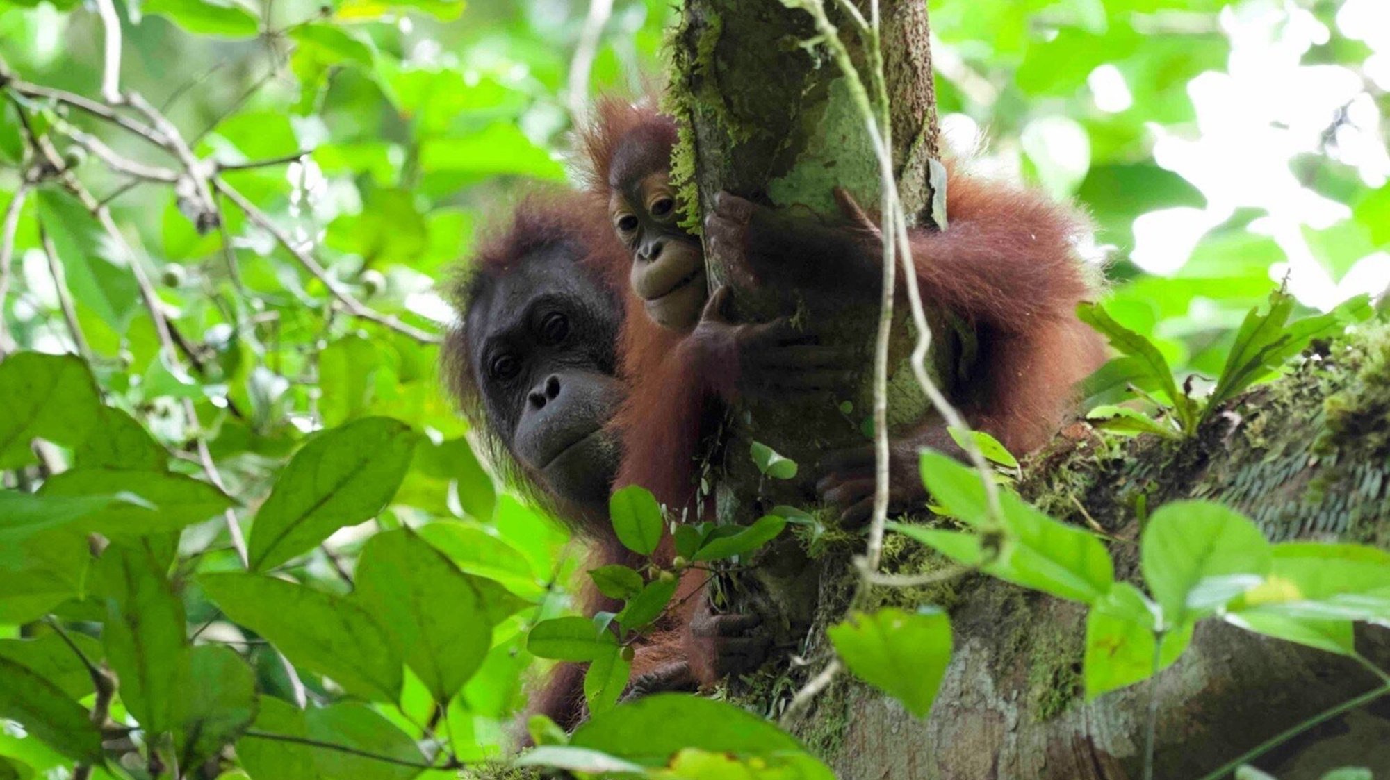
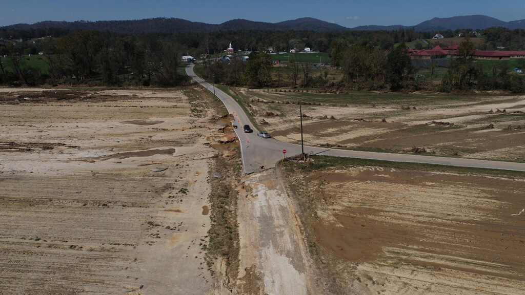
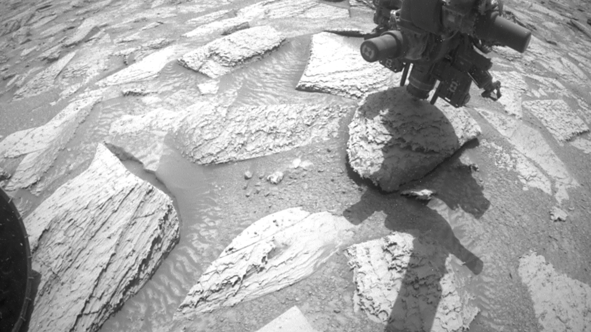


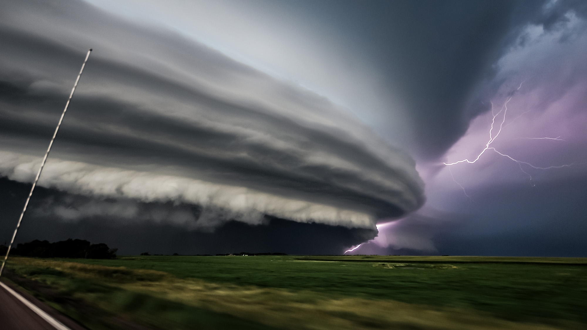
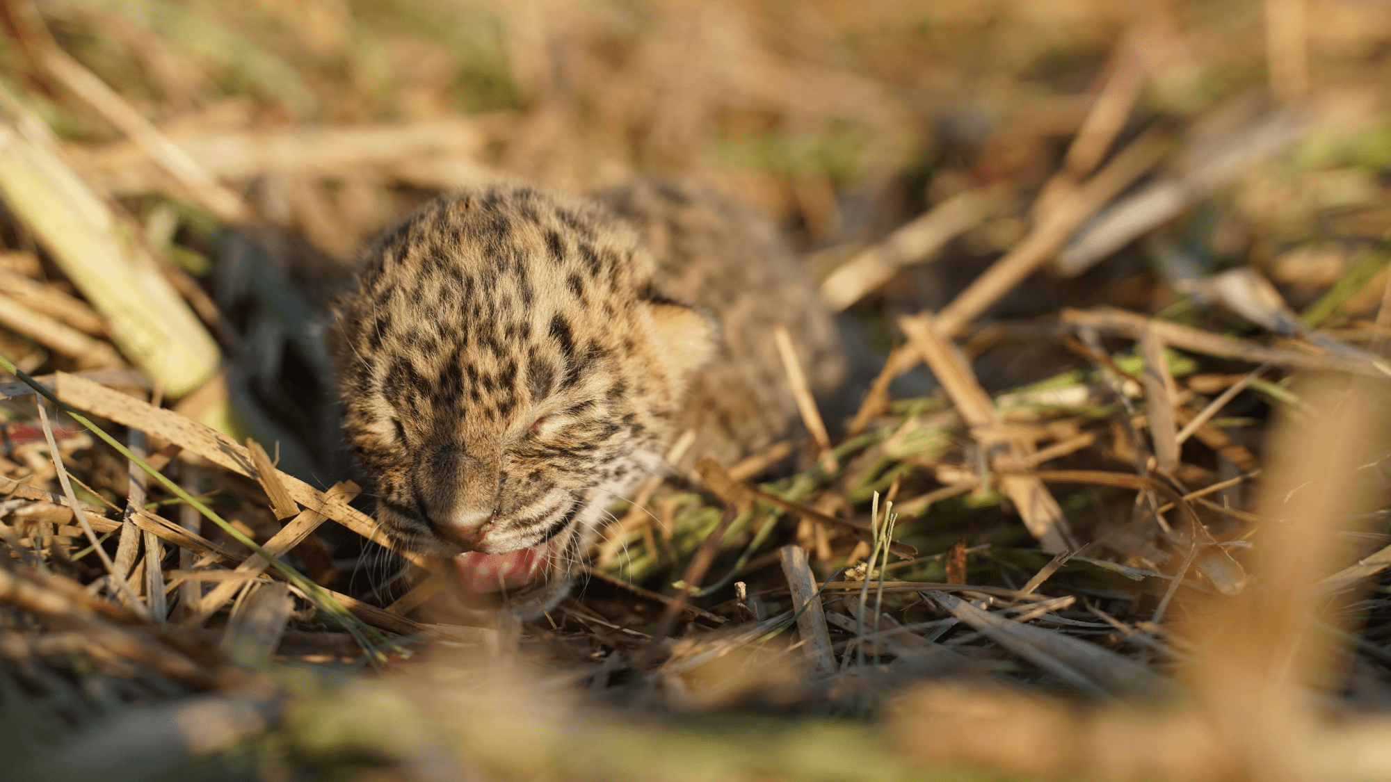
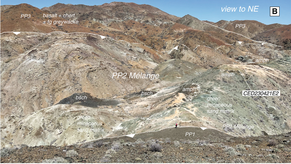
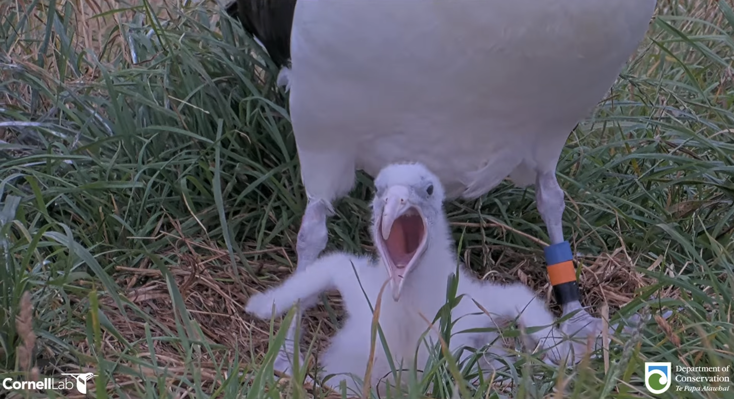

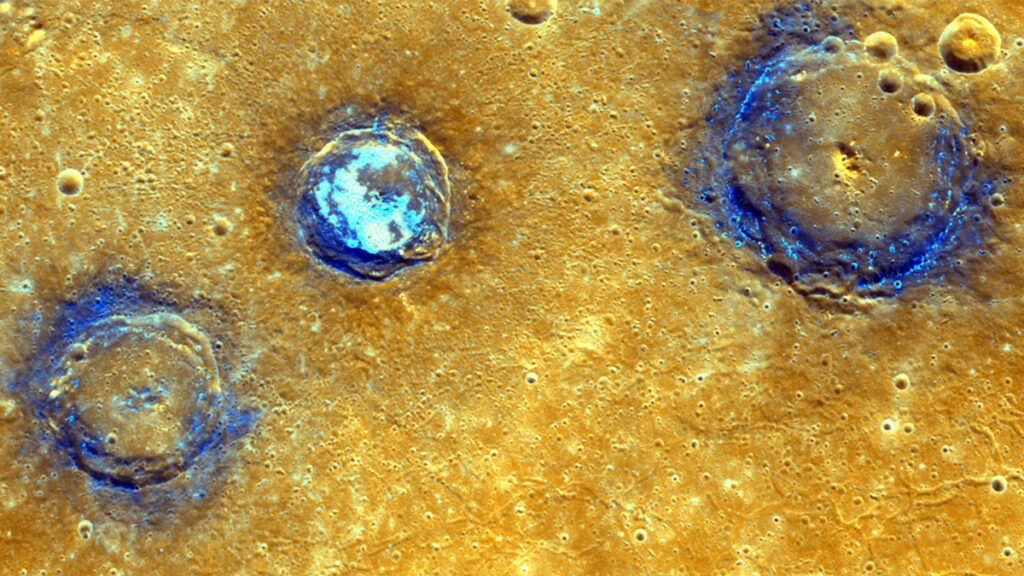
