When photographer Frank Relle was nine years old, he remembers sneaking out of the house he grew up in in New Orleans just before daybreak to catch the sunrise—an event he found frustratingly difficult to explain to others, as much as he wished to share the experience. It was only years later that he discovered the camera, and he reflects on this time now through the lens of an excerpt from the essay “Between Yes and No” by Albert Camus: “A man’s work is nothing but this slow trek to rediscov
When photographer Frank Relle was nine years old, he remembers sneaking out of the house he grew up in in New Orleans just before daybreak to catch the sunrise—an event he found frustratingly difficult to explain to others, as much as he wished to share the experience. It was only years later that he discovered the camera, and he reflects on this time now through the lens of an excerpt from the essay “Between Yes and No” by Albert Camus: “A man’s work is nothing but this slow trek to rediscover, through the detours of art, those two or three great and simple images in whose presence his heart first opened.”
Relle adds, “The swamp was that opening for me. I do not fully understand how. I went in once, and something happened; I changed, and then I kept going back.” The New Orleans-based photographer still returns to the swamps of Louisiana, watched over by bald cypress trees draped in ethereal swathes of Spanish moss. He canoes onto the calm waters, capturing the transition between day and night amid the sounds of birds and other creatures that make their homes there.
“Babsoo”
“I work in the swamp because it returns me to a way of being that feels older, quieter, and more true,” Relle tells Colossal, continuing:
Out there, surrounded by trees, insects, birds, reflections, and dark water, I stop living inside the noise of my own mind. The swamp pulls me out of the island of myself and places me back inside a larger living world. In that state, I feel wonder, connection, and a kind of freedom. Photography became my way of sharing that feeling—not by explaining it but by inviting others into it.
Relle’s series Until the Water explores Louisiana’s otherworldly bayous through a lens of serene reverence. He places lights beneath boughs and trunks, illuminating trees against darkening horizons to emphasize their billowing shapes amid expansive wetlands distinctive to the Gulf Coast region of North America.
Time is both evident and seemingly suspended in Relle’s photos, as within the context of a single day ending or beginning, we observe mature cypresses that may have weathered hundreds of years. (The oldest known living tree in eastern North America is a bald cypress in North Carolina that’s more than 2,600 years old.) Some of the trees are abundantly leafy and full, while others are bare, struggling, or cracked open.
“Lemeire”
“The swamp at two in the morning is not quiet; it is one of the loudest places I have ever been,” Relle says. “But a photograph of it is silent. And in that silence, there is an opening. A threshold….That is what I wanted when I was small, watching the sky change. Not to describe it. To bring someone else to the edge of it. To share it without words.”
Find more on Relle’s Instagram, and purchase prints in his online shop. And if you’re in New Orleans, visit his brick-and-mortar gallery on Royal Street.
Since 1989, Utah’s Great Salt Lake has lost some 70% of its surface area, reducing its ecosystem services and creating stretches of drying lake bed (playa) that send toxic dust into the air.
That drying ground has also provided opportunities for scientists to survey what lies below the lake’s floor. In a study published in Geosciences, researchers revealed glimpses of fresh water and salt water, with some fresh water lurking only a few meters below the surface. The work could provide clues f
Since 1989, Utah’s Great Salt Lake has lost some 70% of its surface area, reducing its ecosystem services and creating stretches of drying lake bed (playa) that send toxic dust into the air.
That drying ground has also provided opportunities for scientists to survey what lies below the lake’s floor. In a study published in Geosciences, researchers revealed glimpses of fresh water and salt water, with some fresh water lurking only a few meters below the surface. The work could provide clues for conserving the lake, a crucial resource for both the ecology and the economy of the region.
Salt Lake, Fresh Water
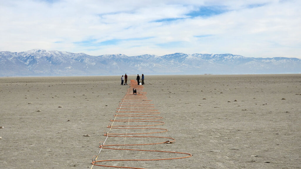
In 2023, Michael Thorne and colleagues began using a technique known as electrical resistivity tomography (ERT), which can reveal the presence of fresh or salty water, at dozens of spots near the southern and eastern edges of the Great Salt Lake. Thorne is a geophysicist at the University of Utah in Salt Lake City and a coauthor of the new study.
The lake’s desiccation allowed the researchers to access areas where “at previous times, you would never be able to do measurements because [they] would be underwater,” said Thorne.
Establishing a network of ERT sensors requires robust fieldwork. Over the course of long days in the field, Mason Jacketta, lead author of the new study, and others placed electrodes into the ground a few meters apart, making lines that stretched hundreds of meters. Between pairs of electrodes, they measured the resistance to electrical current. Salty water, filled with electricity-conducting ions, has lower resistance than fresh water.
Paired with information on the rock and sediment beneath the surface, as well as with measurements from nearby wells, the ERT data allowed the team to work out a profile of how electrical resistance varied with depth and to figure out what kind of water seeped through pores in the ground below. The team shared the results of their work on the southern part of the lake in Geosciences, while more in-depth findings about the eastern shore will appear in an upcoming publication.
“What this is really showing is that [fresh water is] prevalent all over the place.”
At many of the sites, Jacketta and others found fresh water near the surface.
“What this is really showing is that [fresh water is] prevalent all over the place,” said Elliot Jagniecki, a geologist at the Utah Geological Survey who wasn’t part of the work.
That fresh water was often in close proximity to patches of salty groundwater. At one spot in the southeastern part of the lake, the team found a shallow layer of brine. But right below that, at only 5 meters of depth, they encountered fresh water. At the team’s most northern study site, they found fresh water around 2 meters deep. On the southern shore, they found fresh water in some places as shallow as 2.8 meters.
Mysterious Formations
The team’s results also helped explain curious features around the Great Salt Lake, including mounds made of salt and islands made of reeds.
The lacy-looking layers of the lake’s so-called mirabilite mounds form in the winter, when the cold freezes upwelling salty water, concentrating its salts. With measurements taken next to where some mirabilite mounds form, the researchers could visualize the underground conduits that send salty water to the surface.
While mirabilite mounds form close to shore, mounds made of Phragmites reeds appear in the lake’s interior as well as along its periphery. Thorne and his colleague William Johnson first noticed these mysterious circles popping up in Google Maps more than a decade ago. When they went to investigate, they found Phragmites.
“The population of Phragmites around the Great Salt Lake is really not allowing fresh groundwater to go back into the Great Salt Lake.”
In the new work, the team placed a line for electrical resistivity tomography straight through a Phragmites mound. These reeds wouldn’t be able to survive in the lake’s briny water, Thorne said, but the team’s results showed fresh water rising right to where the invasive reeds grew thick.
“The population of Phragmites around the Great Salt Lake is really not allowing fresh groundwater to go back into the Great Salt Lake,” said study coauthor Tonie van Dam, a geophysicist at the University of Utah. The reeds suck up some 70,000 acre-feet of fresh water that could go back into the lake, she said. In “sucking up [fresh water] for their own existence,” van Dam explained, the reeds crowd out native plant species that provide habitat for native birds.
More Than a Beautiful Landscape
Overall, the study provides a new picture of the fresh and salty groundwater beneath the lake and how these resources feed what people observe at the surface.
It’s also helped to prompt other work, Thorne said, including one recent study in which researchers used a helicopter carrying a wire loop to create and sense electrical currents underground. That study, published in Scientific Reports, suggested there could be a large amount of fresh water under one part of the lake.
But that work is a proof of concept, Jagniecki said, and accessing such potential aquifers might not be sufficient to help address the lake’s current desiccation. Even if they could, refilling them could take thousands of years. “I just don’t think that’s a solution,” he said.
Saline lakes are fragile ecosystems sensitive to climate change, Jagniecki said. The Great Salt Lake harbors plenty of life, such as brine shrimp that become food for a host of migratory birds that use the lake as a stopover. Mineral extraction and the use of brine shrimp for feed in aquaculture are important drivers of Utah’s economy.
Getting a better understanding of how saline lake systems function could be helpful in conserving them and maintaining the resources they provide humans, Jagniecki explained.
“It’s actually more than that. It’s a beautiful landscape,” he said.
—Carolyn Wilke, Science Writer
Citation: Wilke, C. (2026), What’s below the Great Salt Lake? More water, Eos, 107, https://doi.org/10.1029/2026EO260127. Published on 21 April 2026.
The City of Calgary has a plan to reduce the water loss rate to 15 per cent by 2030, but it comes with a cost of $342 million over the next four years.
The City of Calgary has a plan to reduce the water loss rate to 15 per cent by 2030, but it comes with a cost of $342 million over the next four years.
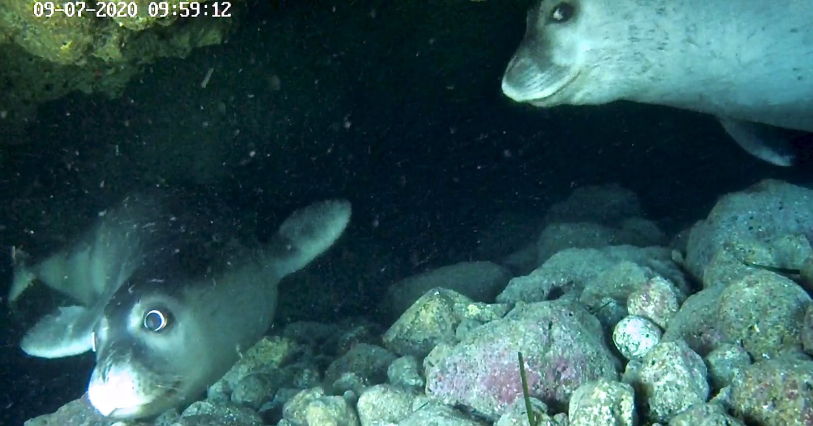
Scientists used remote cameras to reveal how some of the world’s rarest seals are resting in secret underwater “bubble caves” to stay out of sight of humans.
[Read More]
Scientists used remote cameras to reveal how some of the world’s rarest seals are resting in secret underwater “bubble caves” to stay out of sight of humans.
When we picture the effects of melting glaciers, many of us think of rising seas and retreating ice streams. But along Greenland’s coastline, a quieter transformation is underway, one that is affecting how the ocean breathes and how it reacts to and buffers itself against change.
In Young Sound, a fjord carved into Greenland’s remote northeastern coast, decades of monitoring have revealed that glacial meltwater does not simply dilute the salt in seawater. As fresh water enters the ocean, it
When we picture the effects of melting glaciers, many of us think of rising seas and retreating ice streams. But along Greenland’s coastline, a quieter transformation is underway, one that is affecting how the ocean breathes and how it reacts to and buffers itself against change.
In Young Sound, a fjord carved into Greenland’s remote northeastern coast, decades of monitoring have revealed that glacial meltwater does not simply dilute the salt in seawater. As fresh water enters the ocean, it weakens the ocean’s natural chemical resistance to swings in acidity. This so-called buffering capacity keeps seawater pH in balance. The loss of buffering due to freshwater runoff leaves these coastal waters unusually sensitive to even small biological and environmental shifts.
Atmospheric warming is accelerating fastest in the Arctic, and with it come longer glacial melt seasons and increased freshwater runoff. The result is a coastal ocean that is both a frontline witness to climate change and a laboratory for understanding how the chemistry of the seas can change in unexpected ways.
The Ocean’s Chemical Safety Net
Seawater chemistry is naturally buffered by dissolved ions that act as chemical shock absorbers.
Globally, the ocean absorbs about a quarter of carbon dioxide (CO2) emissions each year. That uptake helps to slow climate change, but at a cost. The more CO2 that water absorbs, the more acidic it becomes. Thankfully, seawater chemistry is naturally buffered by dissolved ions—particularly carbonate, bicarbonate, and hydroxide—that act as chemical shock absorbers. These negatively charged ions, collectively called alkalinity, bind to the positive hydrogen ions released when carbonic acid forms, keeping the ocean’s pH relatively stable compared with the more variable conditions in freshwater rivers and lakes.
The polar oceans play a special role in this balance and in the global carbon cycle because cold waters at high latitudes take up carbon from the atmosphere faster than warm tropical waters. Yet these regions are also changing the most rapidly.
When Meltwater Meets the Sea
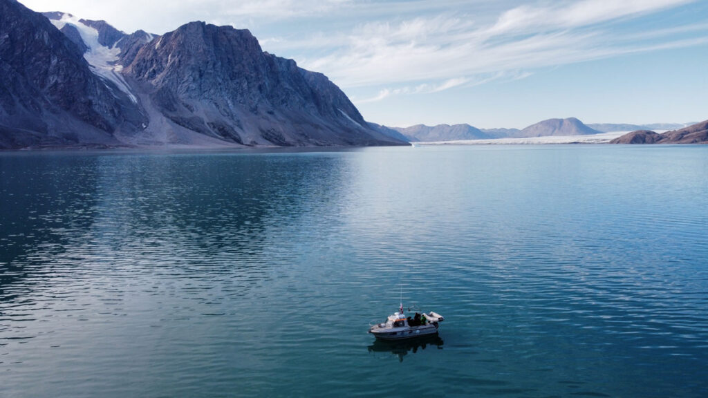
For 20 years, our team at Aarhus University has measured salinity, temperature, and carbon chemistry in Young Sound. Each August, we make the 2-day journey to northeast Greenland, where we spend the month sailing down the 90-kilometer-long fjord to capture these valuable measurements (Figure 1).
Fig. 1. The red line, running from the Greenland Ice Sheet (y) to the Greenland Sea (z), maps the route taken by researchers in August 2023 during their annual transect of Young Sound in northeast Greenland. Credit: Adapted from Henson et al., 2025, https://doi.org/10.1038/s43247-025-02685-4, CC BY-NC-ND 4.0
During the time we have monitored this ecosystem, the melt season has lengthened, with sea ice–free conditions now lasting 8 days longer than 20 years ago. Glaciers feeding the fjord are also thinning and retreating, discharging about 5.5 million cubic meters more water into the fjord each year. These changes have freshened the coastal ocean and subtly, but significantly, altered its chemistry.
Fjords like these have long been known as major CO2 sinks. Surface waters near glaciers often have very low CO2 concentrations, creating a disequilibrium between CO2 levels in the surface ocean and the atmosphere that draws carbon out of the air. But how or why these glacial ecosystems act as carbon sinks and what mechanisms are at play haven’t been thoroughly described. We have also been deeply curious about what else happens when fresh water enters the sea. What are the hidden consequences of this change?
To find out, we paired our long-term field observations with controlled lab experiments in which we mixed glacial meltwater with seawater. Controlled experiments allow us to dig into the nuances of chemical changes that are impossible to measure in the field. We also ran mixing models that allowed us to estimate how the chemistry of those mixed waters responds to small shifts in biological activity or mineral interactions.
The results were striking. When meltwater mixes with seawater, it not only reduces salinity but also dilutes alkalinity, the measure of how well water can neutralize acid and buffer against pH change. This weakening of buffering capacity means that even small changes in photosynthesis or respiration can drive much larger swings in CO2 uptake and acidity than they would in more saline waters.
Two researchers wade into a meltwater river in Tyrolerfjord in Northeast Greenland National Park in 2023 to collect samples bearing the chemical fingerprints of climate change in the region. Credit: Henry C. Henson
We found that in the freshened waters of Young Sound, these processes have 2–3 times the influence on carbon uptake that they do farther out at sea. In effect, meltwater primes the coastal ocean to overreact, amplifying any ecosystem changes that might occur.
Measurements from around Greenland show that this is not just a theoretical risk. Surface waters are measurably more acidic where meltwater inputs are high. The biological consequences of this trend are still uncertain, but species living at the edge of their tolerance, such as shell-forming plankton and Arctic cod larvae, could face growing stress as the chemistry of their habitat fluctuates more widely.
A Fragile Balance in the Freshening Arctic
The findings confirm that fjords absorb carbon as a result of biological activity and glacial input but indicate that they do so in a fragile, easily tipped state.
Our study adds nuance to conventional perceptions of carbon cycling in fjords, long seen as places where atmospheric CO2 is drawn down. The findings confirm that fjords absorb carbon as a result of biological activity and glacial input but indicate that they do so in a fragile, easily tipped state. Slight shifts in the processes that pull CO2 out of the air could tip the scales in either direction: toward even more uptake and the accompanying acidification or toward a release of CO2 to the atmosphere.
This chemical sensitivity explains why Arctic fjords can show such strong seasonal and spatial swings in carbon chemistry and why predicting their long-term role in the carbon cycle is difficult. As glaciers retreat and meltwater inputs grow, those sensitivities are likely to intensify.
At first glance, changes in how seawater in the narrow, remote fjords of Greenland reacts to glacial melt might sound like a local concern. But the chemical processes at play have global resonance.
A tongue of the Greenland Ice Sheet retreats along the tundra as temperatures across the Arctic warm. Credit: Henry C. Henson
Ridges in the Greenland Ice Sheet tell a story of movement and melt. Credit: Henry C. Henson
Glacial meltwater from the Greenland Ice sheet flows into Tyrolerfjord and Young Sound and in Northeast Greenland National Park in August 2023. Credit: Henry C. Henson
The Arctic Ocean as a whole is freshening, driven by accelerating ice melt as well as by increasing river discharge and changing weather bringing more precipitation to the region. Although river water, which arrives from the six great Arctic rivers of North America and Eurasia, is more alkaline than glacial melt, its alkalinity is only about half that of seawater. In other words, river runoff also increases the ocean’s chemical sensitivity. Fresh water also delivers organic matter from permafrost, fine sediments from glaciers, and tannin-rich runoff from tundra soils, each of which can influence carbon cycling and further compound changes already underway.
Similar patterns of increased rainfall and runoff reducing surface salinity are emerging around the Antarctic Peninsula, the Gulf of Alaska, and the North Atlantic. Almost everywhere that fresh water enters the ocean, it lowers alkalinity and limits the ocean’s ability to buffer change.
A Window into Climate Intervention
Our results also carry lessons for researchers and companies contemplating ocean chemistry interventions as ways to remove CO2 from the atmosphere. One proposed approach, ocean alkalinity enhancement, involves adding crushed minerals such as lime, olivine, and basalt to seawater to both counteract acidification and increase the ocean’s capacity to take up CO2.
Glacial systems already perform a natural version of this experiment by grinding rock into fine sediment and discharging it into the ocean. Minerals in this sediment react with seawater and shape its carbon chemistry.
Our study suggests that such reactions are especially potent in freshwater-influenced coastal regions, where reduced buffering capacity may amplify chemical responses not only from natural biological processes but also from potential human attempts to alter seawater chemistry. Thus, understanding the balance between carbon uptake and chemical vulnerability will be essential before any large-scale interventions are attempted.
Consequences Locally and Globally
Coastal communities from Greenland to Alaska to northern Eurasia depend on Arctic waters as part of their cultural identity and, by way of fisheries and tourism, for their economic and food security. As chemical buffering capacity declines, coastal ecosystems may become more susceptible to acidification and other environmental stresses. Small changes in temperature, ecosystem metabolism, or nutrient inputs could then have outsized effects on the marine life that supports these communities.
As coastal glaciers retreat and meltwater rivers carve new paths to the sea, they are doing more than raising sea level and reshaping coastlines. They are rewiring ocean chemistry.
At the same time, changing conditions in coastal Arctic ocean regions complicate scientific modeling of carbon cycling and climate feedbacks, which typically relies on averaged estimates of the ocean’s chemical reactivity. With meltwater making the coastal ocean more reactive, these seas may absorb or release CO2 more variably than how global predictions would suggest. In addition to the real effects on local ecosystems, seawater chemical variability could also affect the accuracy of modeled global carbon budgets, which we use to inform future climate projections and guide international policy goals.
As coastal glaciers retreat and meltwater rivers carve new paths to the sea, they are doing more than raising sea level and reshaping coastlines. They are rewiring ocean chemistry, leaving it fresher and more easily disturbed.
The chemical sensitivity we see in Greenland’s fjords today may be a preview of what is to come in many coastal regions. If so, then we must be concerned with not only how much CO2 the ocean can absorb but also how stably it can hold that CO2 in a rapidly changing world.
Author Information
Henry C. Henson (hch@ecos.au.dk), Aarhus University, Denmark
Citation: Henson, H. C. (2026), Melting glaciers make the coastal ocean more sensitive, Eos, 107, https://doi.org/10.1029/2026EO260116. Published on 16 April 2026.
Research & Developments is a blog for brief updates that provide context for the flurry of news that impacts science and scientists today.
In the contiguous United States, crop irrigation, municipal water supplies, and thermoelectric power generation use more than 224 billion gallons of fresh water every day. Conducting water research or making decisions about water use, until now, often required referencing datasets across various agencies. The U.S. Geological Survey (USGS) National
Research & Developments is a blog for brief updates that provide context for the flurry of news that impacts science and scientists today.
In the contiguous United States, crop irrigation, municipal water supplies, and thermoelectric power generation use more than 224 billion gallons of fresh water every day. Conducting water research or making decisions about water use, until now, often required referencing datasets across various agencies. The U.S. Geological Survey (USGS) National Water Availability Assessment Data Companion (NWDC), announced this week, aims to streamline this process. In part, the tool is designed to help decisionmakers better understand the balance between how high demand and limited supply affect water availability in their communities.
“While the United States has abundant water nationally, regional imbalances between supply and demand may create water challenges affecting millions of Americans,” said lead scientist Shirley Leung in a USGSpress release. “What once required significant resources and time can now be done in minutes, giving communities of all sizes the same foundation for water planning.”
The lower 48 states are home to about 80,000 sub-watersheds, from those in the arid southwest to the Great Lakes Basin, where about 84% of North America’s surface fresh water is located. According to the USGS, the NWDC is the first tool that integrates information about water availability in individual watersheds at a national scale.
The tool is designed to complement Water Data for the Nation (WDFN), another USGS product that consolidates observational data from the agency’s thousands of local monitoring stations gathering data on streams, lakes, reservoirs, precipitation, water quality, and groundwater. The new tool uses modeling to fill in spatial and temporal gaps between the observations made at these stations.
Water managers, researchers, agricultural experts, and others can use the NWDC to compare watershed conditions, identify seasonal patterns in water use, or to create data visualizations of statewide water use, for example. Though the tool currently covers only the contiguous United States, it will soon be extended to Alaska, Hawaii, and Puerto Rico, according to the USGS.
David Tarboton, a professor of civil engineering at the Utah Water Research Laboratory, said he was “intrigued” by the new tool, and is interested in examining the data its model produces.
While Tarboton was disappointed that the tool’s most recent available data are from 2020, “having a sort of integrated, wall-to-wall dataset that’s consistently produced is very valuable,” he said. He works, in part, in the areas of hydroinformatics and data sharing, and noted that the modern methods the agency is using to share the data could be useful in developing automated tools.
These updates are made possible through information from the scientific community. Do you have a story about science or scientists? Send us a tip at eos@agu.org.
It’s an exciting weekend for indies film with two surprise global juggernauts by first-time directors who jumped from the internet to the big screen. More traditional independent releases were led by a nice opening for Pressure and a solid expansion by Tuner. It’s been well reported but noting the two unusual indie horror films, A24’s […]
It’s an exciting weekend for indies film with two surprise global juggernauts by first-time directors who jumped from the internet to the big screen. More traditional independent releases were led by a nice opening for Pressure and a solid expansion by Tuner. It’s been well reported but noting the two unusual indie horror films, A24’s […]