First Reading is a Canadian politics newsletter curated by the National Post’s own Tristin Hopper. To get an early version sent directly to your inbox, sign up here.Read More
Less than €200,000 of a €1 million State fund to support zero-emissions heavy goods vehicle (HGV) infrastructure was spent last year, with €188,000 of that going on administrative costs, the Dáil has heard.
As an American expat who has been living in the south of Italy for the past three years, I’ve picked up on several differences in the way Italians value work compared to the American point of view.
You’ve already heard of la dolce vita…it turns out it’s a part of the culture that Americans could stand to emulate. Here are a few of the practices and mindsets I’m working to adopt in my new home.
1. You Are Not Defined by What You Do
Go to a cocktail party in the U.S. and inevitably, one of the first things a stranger will ask you is: “So, what do you do?”
We’re obsessed with our jobs, and we wear them as masks that define us. Italians, on the other hand, don’t identify themselves by the work they perform. In fact, it’s rare that I talk about work with friends here.
Italians, instead, are more keen to talk about what they’re into. Often, this means what they ate or what they’re planning to eat! They also talk about the animals they’re raising, the weather, and the latest gossip.
I think Americans could stand to dissociate a bit from their work. After all, we are comprised of many things, and work is but one component!
2. Take Your Breaks Seriously
In the south of Italy, everything (except large grocery stores) shuts down from noon until four. That means if you want to pop into a store or get your teeth cleaned at midday, you’ll be in for a disappointment.
I love that Italians completely stop working for these hours. They have a big lunch with the family (no microwaved meal at their desks) and then maybe take a nap.
Americans, on the other hand, never stop working. We check our email obsessively after hours and on the weekends, for fear of missing some critical message that will explode if not opened instantly.
Italians understand that taking a break helps us regulate our stress levels. Even if you’re having a terrible day at work, taking a four-hour break (and a nap) will remedy it! And Italy actually has laws in place that prevent employees from being available for work outside of normal work hours. I love this!
I don’t expect American corporations to adopt a giant break in the middle of the day, but you personally can at least limit your availability to your traditional work hours.
3. Don't Be Afraid to Pivot
When I met my husband, he was a librarian. And a tour guide. He’d been an archeologist, and now he teaches Italian.
I know few Italians here in the south who stick to one job their whole lives. This is, in large part, because there aren’t a lot of jobs for people with degrees in the south (there is a brain-drain exodus issue that started in the 1950s when southerners moved to the north to find work). And since Italians don’t identify with their work in the same way as Americans, there’s no shame in changing lines of work.
I’ve even done it myself; as AI has taken more writing jobs from me, I’ve ventured into other jobs, like training AI and teaching English.
4. A Vacation Should Be Relaxing
I know Americans who, when they go on vacation, plan a whirlwind trip that leaves them little time to actually relax.
Here in Italy, many people take the entire month of August off. Employers don’t get mad; they close shop and head to the beach, too. I live near the Ionian Sea, and every August, Italians from the north flock here to do little more than soak up the sun, eat our spicy peperoncini, drink Calabrian wine, and enjoy family. They’re not interested in seeing the sights or taking the kids to a theme park. For Italians, a vacation is designed to be enjoyed, not overstuffed with activities.
5. There’s Always Time for Life’s Pleasures
I live in a small mountain village in Calabria, and just about everyone here owns at least one piece of land where they grow gardens and raise chickens and maybe a goat or two. They have jobs, but after hours, they roll up their sleeves and dig in the dirt.
Yes, it can be a labor of love. Someone’s got to till the land, and that’s tedious work. But there’s such joy when we’re all together, planting fava beans or harvesting olives, knowing that we raised the food that we now will enjoy. A crisp beer and a few laughs, and it feels nothing like work.
I’ve fallen in love with herbalism, and my walks in the mountains gift me with armfuls of flowers and herbs I use in food, medicine, and skincare products. We all have something that brings us joy outside of work, and that’s how it should be.
In Italy, we work so that we can live better. In America, people live to work. There’s a big difference, and it shows. Personally, I think we could all learn a few things from the people who live longer, eat better, and generally seem to be happier.
Bogotá, Colombia – The first global summit on “Transitioning away from Fossil Fuels” kicked off today in Santa Marta, Colombia, with 50 country delegations and dozens of civil society organizations in attendance.
Unlike other climate conferences, the six-day meeting will focus on implementing measures to end dependence on oil, coal, and gas, rather than negotiating international environmental commitments.
The summit comes at a pivotal time for global energy, with conflict in the Middle East restricting oil and gas supplies and creating economic woes for countries reliant on fossil fuels.
Because of the ongoing oil turmoil, the conference came at the “best possible moment” to shift world opinion towards renewables, said Colombia’s environment minister Irene Vélez.
Talking to the UK’s Guardian newspaper this week, the minister, who was a prime mover of the conference, said nations were “at a fork in the road” in their choices between clean power sources such as solar or wind, or continuing to back fossil fuels that created climate crises and conflict.
It promised to be a “coalition of the willing”, said the minister, providing a road map to support nations already dedicated to transitioning from fossil fuels.
The conference organizers were combative in refusing to invite nations and organizations wedded to climate change denial.
“Whatever nations have not yet taken that decision, then this is not the space for them. We are not going to have boycotters or climate denialists at the table,” Vélez told the Guardian.
Behind the conference is the Fossil Fuel Treaty Initiative, an alliance of nation states, technical bodies, communities and individuals “working to secure a global just transition from coal, oil and gas”.
According to the initiative, globally nations were planning to extract 120% more fossil fuels by 2030 than the “amount consistent with managing the impacts of climate change” – taking warming past the point of survival.
“The science is unequivocal. For the last decade, oil, gas, and coal have been responsible for 86% of the CO2 pollution heating our planet, as well as causing one in five deaths worldwide from fossil fueled-air pollution.”
Delegates at the inauguration of the fossil fuel conference on Friday. Image credit: @MinAmbienteCo via X
For three decades global climate negotiations had focused on managing the symptoms of the crisis — fossil fuel emissions — while ignoring its root cause: the unchecked proliferation of oil, gas, and coal extraction.
This was a theme picked up by Kevin Koenig, director of climate and energy at Amazon Watch, a California-based nonprofit supporting indigenous communities attending the conference.
The last major summit, COP 30, was held last year in Brazil and saw “fossil fuel lobbyists outnumbering country delegates” he told Latin America Reports, adding that declarations at the end of that meeting “barely mentioned fossil fuels at all”.
In Santa Marta he expected things to be different: “This is the conference that is finally going to address the elephant in the room and get to the source of the climate change problem.”
Several factors were contributing to a momentum towards renewables, added Koenig, with recent data showing that cities and even whole countries have run for weeks off renewable energy as the Middle East crisis exposes the dangers of oil addiction.
“This is the moment where we are seeing both wars linked to fossil fuels politics and dependencies, but also for the first time renewables energies are not just theoretical, they are real, and decision-makers know they are scalable,” said Koenig.
This was supported by data from the Center for Energy and Clean Air, which reported that global power generation from fossil fuels fell in the first month after the U.S.- Iran conflict closed the Strait of Hormuz – a vital waterway for oil tankers – while energy generated by solar and wind power increased.
Another conference goal was to identify economic and legal barriers to transitioning to renewables, said Koenig.
An example was the hegemony of interconnected global norms feeding fossil fuel dependence, such as arbitration laws that punished small countries in international courts if they attempted to free themselves from big oil contracts. This architecture kept countries dependent, he said.
“Countries transitioning get beat up in arbitration courts or penalized by credit rating agencies. When Ecuadorians voted to keep fossil fuels in the ground, for example, their credit rating went down.”
In countries like Colombia, fossil fuels were also linked to localized conflict and armed groups, explained Koenig; over 30 years Amazon Watch has supported many indigenous communities under attack for defending their territories against drilling.
“Some countries use oil extraction as a reason to open areas, saying ‘we can militarize it and it will be safer’. In fact, oil and energy infrastructure are a magnet for armed groups, for political attacks or blackmail,” he explained.
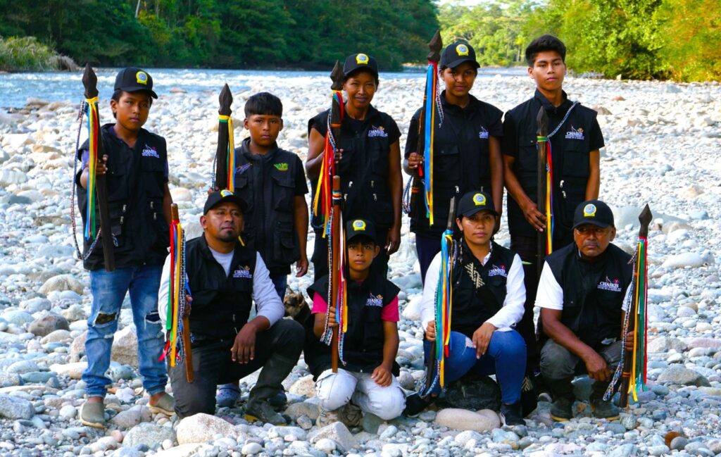
Inga indigenous guards in Putumayo, Colombia. Their traditional lands are under threat from oil exploration and illegal mining. Photo: Steve Hide.
That dynamic was more visible than ever on the world stage.
“Fossil fuels are fueling dictatorships, violence, conflict and authoritarian regimes,” said Koenig. “The Middle East crisis underscores the urgency to transition.”
“Yes, abandoning fossil fuels is about climate – but also about security and democracy.”
Featured image description: Delegates register at the fossil fuel conference in Santa Marta on April 24, 2026.
“It may sound small, but it’s reshaping daily life.”
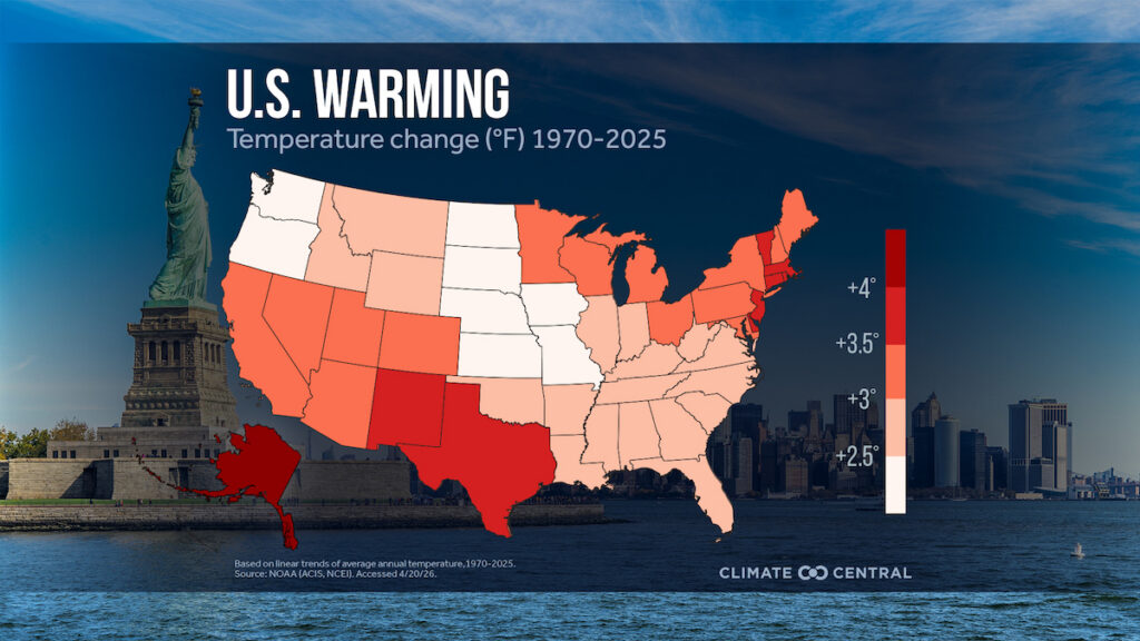
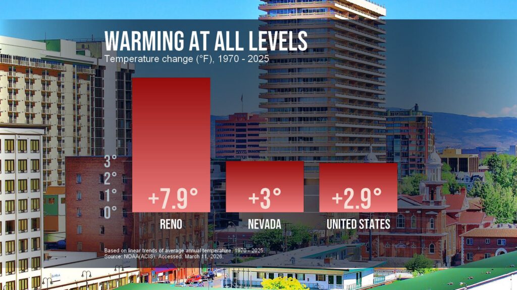
Changes in average annual temperatures in U.S. cities and states show the powerful effects of this increase in heat-trapping carbon dioxide. A new analysis, published today by climate research and communications nonprofit Climate Central, found that since 1970, all 50 states and 99% of major U.S. cities have warmed, with an average city-level increase of 1.6°C (2.9°F).
“It may sound small, but it’s reshaping daily life,” Shel Winkley, a meteorologist at Climate Central, said in a video released alongside the report.
On average, the 49 U.S. states analyzed in the report have warmed by 1.7°C (3.0°F) since 1970. The six states that have warmed the fastest since the first Earth Day are Alaska with a 2.4°C (4.4°F) increase, New Jersey and New Mexico with a 2.1°C (3.7°F) increase, and Delaware, Massachusetts, and Vermont with a 2°C (3.6°F). Trends for Hawaii, which were analyzed separately and not included in the national average, also showed statewide warming.
In 2025, the United States was on average 1.4°C (2.6°F) warmer than the 20th century average. The Paris Agreement, a legally binding global treaty, sets a goal to limit warming to 1.5°C (2.7°F) above preindustrial levels, though some scientists expect that the world has already entered the period of time during which this limit will be breached.
Warming is occurring much faster in some cities than in their respective states, or than the United States as a whole. Check out your city’s data in the Climate Central report. Credit: Climate Central, CC BY 4.0
Warming trends in the United States are most pronounced in the Southwest, where cities have warmed an average of 1.9°C (3.5°F) since 1970. And in some cases, cities are warming much faster than whole states. Three of the five cities that have warmed the fastest since 1970 are in the Southwest: Reno, Nev., with an increase of 4.4°C (7.9°F), Las Vegas, with an increase of 3.3°C (6.0°F), and El Paso, Texas, with an increase of 3.3°C (5.9°F).
The effects are evident at the national, state, and local levels. Temperatures have warmed in 240 of the 242 cities analyzed by Climate Central. Harrisonburg, VA and Monterey, CA were the only two cities analyzed that have not warmed since 1970.
The report highlights some good Earth Day news, however, and points out that solar and wind power generation is at an all-time high in the United States, accounting for 19% of the electricity generated in the country in 2025 despite those industries facing recent headwinds from the federal administration.
“Every fraction of a degree [of warming] that we prevent does matter, for our health, for our communities, and for the world that we’re passing on to the next generations,” Winkley said.
These updates are made possible through information from the scientific community. Do you have a story about science or scientists? Send us a tip at eos@agu.org.
Planting more trees will decelerate climate change only if those trees are placed in optimal locations—primarily the tropics and subtropics—suggests new research published in Communications Earth and Environment. However, planting trees in locations like Alaska, Siberia, and large parts of the United States could actually lead to warming, said lead author and doctoral student at ETH Zurich Nora Fahrenbach.
Much of the current thinking in nature-based solutions, Fahrenbach said, is based on the idea that “more is better.”
As in, “we’ll plant a trillion trees, or we’ll plant more than a trillion trees, and we are going to get more cooling, right?” Fahrenbach said. “That’s something we show is just not the case.”
Fahrenbach researches reforestation potentials, or global maps that identify areas where trees could be planted to mitigate climate change. In this work, she and her colleagues compared three prominent reforestation potentials to determine the effect of tree placement on local and global temperatures.
One scenario involved reforesting about 926 million hectares focused mostly on the tropics and resulted in about 0.25°C of cooling by 2100. Another called for reforesting 894 million hectares, including large areas in northern temperate and polar latitudes, and resulted in 0.13°C of cooling by 2100.
The third scenario involved planting forests strategically over only 440 million hectares of mostly tropical and subtropical land (less than half of the area covered in the other scenarios) but also resulted in 0.13°C of cooling. Geography, the findings suggest, may matter more than quantity when it comes to the cooling benefits of reforestation efforts.
Let’s Get (Biogeo)physical
The researchers modeled all three scenarios using the same parameters: Trees were planted from 2015 to 2070 and then remained steady in their population until 2100.
Planting trees in one area doesn’t just change the local temperature but has effects across the world.
All three models identified reforestation opportunities in regions such as the eastern United States, Amazonia, the Congo rainforest, and eastern China, as well as regions for which reforestation would not be as impactful, such as polar regions in the Northern Hemisphere. The researchers also found significant temperature changes across the Atlantic and Indian oceans as a result of atmospheric changes induced by reforestation, demonstrating an interconnected reality: Planting trees in one area doesn’t just change the local temperature but has effects across the world.
These local and nonlocal effects can be explained by a combination of biogeochemical and biogeophysical effects.
A biogeochemical effect relates to the movement of chemicals or chemical elements, such as trees absorbing carbon from the atmosphere.
A biogeophysical effect relates to the physical results of changing the land’s surface: Placing a tree in a snowy region, for instance, decreases the land’s albedo, meaning it causes the land surface to become darker and absorb more light, leading to more local heat. This rise in surface temperature also raises air temperature, creating cascading effects on wind patterns and oceanic currents.
Considering both processes together is essential for understanding whether a net cooling or net heating effect exists, but most policies focus only on biogeochemical effects, seeing trees solely for their ability to absorb carbon from the atmosphere, Fahrenbach said. They include prominent international policies such as the Paris Agreement and the United Nations’ Framework for REDD+.
“Really, we would also need to consider the biogeophysical effects,” Fahrenbach said. “That’s harder to do, right, considering those nonlocal effects, because just imagine, some country is going to plant a lot of trees, and that’s going to lead to warming somewhere else.”
A Call to Policymakers
Emilio Vilanova, a forest ecologist at the climate action nonprofit Verra, wrote by email, “The most important message for me is that this study emphasizes something that is often not well addressed in reforestation projects: Reforestation is not just about planting trees—it’s about designing where new forests go to maximize benefits and avoid unintended consequences.”
“Reforestation is a helpful tool, not a stand-alone solution to climate change.”
Vilanova also said the study puts the potential for reforestation efforts to address climate change in perspective. “Even very large reforestation efforts would only reduce global temperatures by about 0.13–0.25°C by the end of the century,” he said. “While meaningful, this finding also reinforces that reforestation is a helpful tool, not a stand-alone solution to climate change.”
Though the limited potential for change is sobering, the authors and Vilanova pointed out that this change does matter and that it matters how we think of our approach. They advocate for policies that adopt reforestation strategies based on location and that acknowledge both the local and nonlocal effects of reforestation.
“We really need to make sure that where we plant first, it has benefits locally, it has benefits globally,” Fahrenbach said.
22 April 2026: This article was updated to correct Nora Fahrenbach’s position at ETH Zurich.
This news article is included in our ENGAGE resource for educators seeking science news for their classroom lessons. Browse all ENGAGE articles, and share with your fellow educators how you integrated the article into an activity in the comments section below.
Citation: Meissen, A. (2026), Location, location, location: The “where” of reforestation may matter more than the extent, Eos, 107, https://doi.org/10.1029/2026EO260125. Published on 22 April 2026.
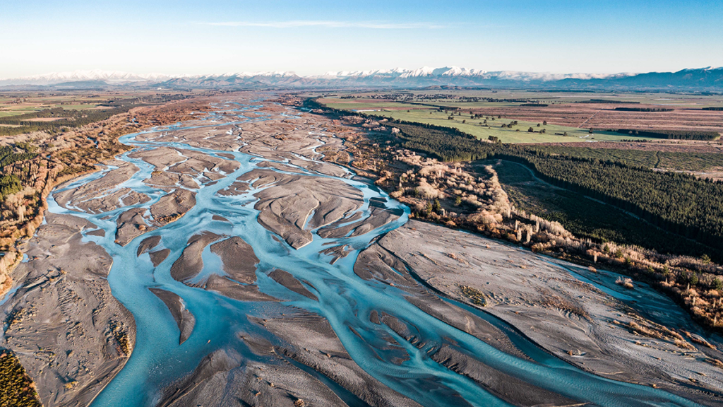
The evolution of rivers that split into multiple channels is a scientific challenge in terms of modeling and prediction. On the other hand, these rivers are widespread and play a key role for ecosystems’ life, groundwater recharge, and therefore, water security. They are also extremely sensitive to hydroclimatic changes, leading to shifts in precipitation, erosion and sediment transport.
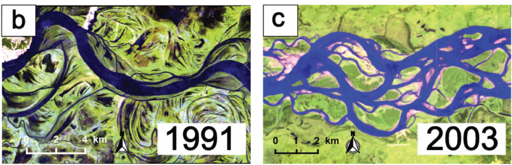
Zhao et al. [2026] investigate the drivers of river evolution for 97 multithread river reaches worldwide, spanning diverse climates and morphologies. The study reveals the key role of intermittency for river evolution. In particular, higher flow intermittency could lead to more even flow partitioning among threads, therefore impacting hydrology and ecosystems. With flow variability increasing after climate change, rivers are likely to increase their thread count, thus impacting livelihoods and ecosystems.
Two example multithread reaches shown in Landsat images from (b) the Irtysh River (wandering) and (c) the Yukon River (braided). Credit: Zhao et al. [2026], Figure 1(b,c)
Citation: Zhao, F., Ganti, V., Chadwick, A., Greenberg, E., McLeod, J., Liu, Y., et al. (2026). Global hydroclimatic controls on multithread River dynamics. AGU Advances, 7, e2025AV002166. https://doi.org/10.1029/2025AV002166
In March 2026, the Arctic’s winter sea ice reached one of the lowest levels ever recorded, at 5.52 million square miles, about 10% below the 30-year average. This was 10,000 square miles less than the 5.53 million square miles measured in 2025. The Arctic winter sea ice covered 5.56 million square miles in 2017 and 5.79 million square miles in 2020, and has been declining since then.
Less white ice means more dark ocean water, and dark water absorbs heat rather than reflecting it, speeding up warming, or so we are told. Yet, any helmsman will attest that the ocean is never truly black, except on a moonless night. Light reflects off the sea as brightly as the sky. A cloud-covered sky lowers the reflection, turning the ocean gunmetal gray.
Science is a cycle of observing, questioning, recording, and sharing. Imagine practicing science with a pair of pint glasses on a sunny day. Fill one glass with cold black coffee and the other with cold white milk. Place a thermometer in each and observe what happens over time.
Both the pint of coffee and the pint of milk will reach the same temperature as the air. The heating occurs through conduction, with the glass in contact with the air. Unlike a black car seat, water molecules are free to move. The chaotic motion of warming water molecules makes it impossible to heat water in a glass or coffee in a mug above room temperature with a hair dryer. Dark waters are not warmed by sunlight and so are not responsible for melting sea ice. Waters are warmed by contact with warmer surfaces, like when a coffee pot is placed on the stove.
The Arctic Ocean connects to the Atlantic Ocean via the Greenland Sea, which is part of the Atlantic. The Svalbard Archipelago is on the threshold between the two oceans. To the east of Svalbard is the Barents Sea. Covering about 540,000 square miles, the Barents Sea is north of Norway and Russia and west of Franz Josef Land. On the continental shelf, it is relatively shallow, with an average depth of about 750 feet. The average depth of the Arctic Sea to the North is about 3,900 feet.
The Arctic isn’t melting uniformly like a spring pond. Melting starts with warm Atlantic Gulf Stream water. Nearly all the Arctic Sea ice loss, totaling 525,000 square miles, happens in the Barents Sea, a part of the Arctic Ocean. This occurs because of the Coriolis Effect, a phenomenon caused by the Earth’s eastward rotation. The equator moves faster through space than the North Pole. As a result, water flowing north curves to the right. When it enters the Arctic, warm Atlantic water flows directly into the Barents Sea.
In April 1810, the whaler William Scoresby lowered a ten-gallon wooden cask made of fir into the deep after overwintering in the Greenland Sea west of Svalbard. This design was by Joseph Banks, the scientist on Cook’s expedition. Fir was the preferred wood because it is a softwood that insulates better than harder woods. Scoresby was surprised to find that the Gulf Stream water at 100 to 200 fathoms deep was six to eight degrees warmer than the Arctic water above. He didn’t believe it at first and modified the cask to record the temperature more quickly. However, the results were consistent. The Gulf Stream was flowing into the Arctic Ocean, separated from the sea ice by a layer of less salty, denser Arctic water.
Besides discovering changes occurring in the Greenland Sea, Scoresby observed, “changes of climate to a certain extent, have occurred, …, considered as the effects of human industry, in draining marshes and lakes, felling woods, and cultivating the earth” (Scoresby 1821, page 263).
Over time, the loss of vegetation and soils, replaced by hard surfaces that have become heat islands, has resulted in more and warmer stormwater runoff into the Atlantic. This happened without a change in annual rainfall. More water strengthens the Gulf Stream, and as temperatures rise, the expanded water has moved closer to the surface in the Arctic.
In 2007, the Gulf Stream surfaced in Svalbard, and warm water began melting glaciers on land.
During the winter of 2010-2011, the Gulf Stream was observed to have a more pronounced meander onto the Continental Shelf closer to Rhode Island than ever before. This indicates a need for a strengthened Gulf Stream to dissipate more energy.
The Gulf Stream flows past New Jersey at 30 to 40 Sverdrups, or 30 to 40 million cubic meters per second, with a seasonal variation of 5-15%. Maximum flow usually occurs in late summer to early fall. It gathers water as it barrels northward. The Gulf Stream transports more than 100 Sverdrups east of the Grand Banks off Newfoundland,
Only 2-3% of the total Gulf Stream flow is carried by the Norway Current into the Barents Sea, but it punches far above its weight in terms of climate impact in the Arctic Ocean.
Atlantification is the process by which warm Atlantic water melts Arctic sea ice. This leads to thinner winter sea ice that melts faster in summer. NASA imagery shows the Siberian coast from Norway to Alaska opening nearly simultaneously. The counter-clockwise gyre created by Atlantic water entering the Arctic pushes ice against Canada and Northern Greenland.
Rounding Greenland, the Arctic Ocean current flows south along Greenland and into the Denmark Strait between Iceland and Greenland. Here, the cold, nutrient-rich Arctic water meets warm, nutrient-poor Atlantic water and plunges 11,500 feet down. The Earth’s largest waterfall, three times taller than Angel Falls, is underwater.
The East Greenland Current will become the Labrador Current after rounding Greenland, carrying oxygen-rich and nutrient-rich waters into the Atlantic. The Grand Banks off Newfoundland will force Arctic waters to mix with warm, salty water, creating arguably the world’s most productive fishing region.
The Northeast Passage, the Arctic Ocean sea route from the Atlantic along the coast of Siberia to the Pacific, opened in the early 2000s. In 2007, the Northwest Passage through the Canadian Arctic Archipelago opened to shipping. The close timing of the two passages’ openings was a surprise, given our understanding of oceanography. However, solar radiation off the granites and gneiss (igneous and metamorphic) rocks of the Canadian Shield made the difference for a region where warm Atlantic water could not reach.
We need to reduce surface runoff by increasing vegetation cover and soil depth to help water stay on the land where it falls, while restoring the Arctic’s winter sea ice and cooling the climate. Additionally, we should naturally lessen the heat island effects of our structures by providing more shade and transpiration cooling from plants. Slowing down water flow during times of abundance to ensure it is available where and when nature needs it will lower seasonal ocean warming.
There are immediate benefits to having more water on land, such as more greenery, less warming, and decreased ocean swelling. The advantages for land, water, and sky are vast and difficult to fully understand. Still, the benefits of restoring Arctic sea ice are clear and serve as a clarion call for responsible local actions by all property owners, no matter where they are in the watershed we call Earth.
About the Author
Dr. Rob Moir is a nationally recognized and award-winning environmentalist. He is the president and executive director of the Ocean River Institute, a nonprofit based in Cambridge, MA, that provides expertise, services, resources, and information not readily available locally to support the efforts of environmental organizations. Please visit www.oceanriver.org for more information.
As climate change increases the frequency and intensity of flooding, it’s becoming increasingly important to monitor and predict flood hazards at different scales. A new article in Reviews of Geophysics presents a data-driven performance analysis of various space-based sensors that monitor flood hazards. Here, we asked the lead author to give an overview of satellite-based flood monitoring, the benefits and challenges of using satellite-based sensors, and future space-based projects.
Why is it important to monitor the surface waters on Earth?
More than half of the world’s population lives within three kilometers of a freshwater body. When seasonal flooding behaves as anticipated, it provides essential nutrient replenishment to soils and crops. However, extreme flooding disturbs the careful balance of freshwater systems and can cause damaging flooding that disrupts livelihoods.
Climate change is making these extremes more frequent and less predictable, while expanding populations in flood-prone areas amplify the human cost. Continuous monitoring of Earth’s surface waters is essential as it helps us anticipate hazards, evaluate risk, and design interventions that protect the people and places most exposed to hydrologic hazards.
What are the benefits of monitoring flood inundation from space compared to other techniques?
Monitoring flood inundation from space is advantageous due to the wide-scale global coverage that captures important information over large areas. In-situ sensors, such as river gauges, provide valuable data but are limited in spatial coverage and may even fail under significant flood conditions. A single satellite overpass can potentially capture an entire river basin, allowing responders to see where water has spread, which communities are affected, and how the event is evolving.
When did scientists first start using satellites to monitor surface waters?
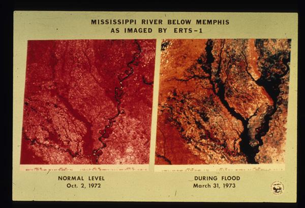
The value of monitoring surface water from space was first realized in the early 1970s, following the launch of Landsat 1. Soon after launch, it captured imagery of the devastating 1973 Mississippi River floods, producing one of the first flood maps made from space (Figure 1). By the early 2000s, NASA’s MODIS sensors were providing global coverage at a daily frequency. Today, multiple global flood monitoring systems are in place, including the European Union’s Copernicus Emergency Management Service, which maps floods using Sentinel-1 synthetic aperture radar (SAR), and NOAA’s VIIRS Flood Mapping system.
Figure 1. Imagery from the start of the Landsat 1 mission illustrating the extent of the Mississippi River flooding of 1973 (EROS History Project). The Earth Resources Technology Satellite 1 (ERTS-1) was renamed Landsat 1 in 1975. Credit: USGS
What are the three types of satellite-based sensors that your review focuses on?
Our review examines three families. Multispectral (optical and thermal) sensors capture reflected sunlight or emitted heat. Microwave sensors, including SAR, passive microwave radiometers, and GNSS Reflectometry (GNSS-R), can observe through clouds and at night but involve trade-offs between resolution and coverage. Finally, altimetric sensors measure water surface elevation with high precision but only along narrow tracks. Each family has distinct strengths and weaknesses that lend themselves to use in combination for comprehensive flood inundation monitoring.
What are some of the challenges of using satellite-based sensors to monitor flooding?
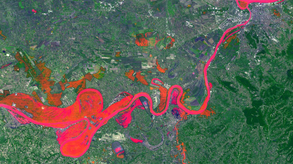
The fundamental problem is that floods and satellite observations are mismatched in time and space. Optical sensors often capture clouds rather than the floodwater beneath. Cloud-penetrating sensors like SAR can miss flood peaks if their orbital schedule doesn’t align with the event, and dense vegetation can obstruct floodwater from both optical and shorter-wavelength radar. Sensors with high temporal resolution typically deliver data at coarse spatial resolutions, sometimes tens of kilometers per pixel. These trade-offs form what we describe as the “iron triangle” of Earth observation: temporal resolution, spatial resolution, and cost. A sensor can typically be optimized for two, but rarely all three. Occasionally, the timing and conditions of a flood align well with sensors whose strengths are complementary across the iron triangle, yielding the kind of multi-sensor view shown in Figure 2.
Figure 2. Sentinel‐2 MSI True Color Image with Sentinel‐1 SAR derived flood‐extent superimposed on top. The top right circle highlights the missing SAR‐derived information, whereas the bottom circle highlights the missing optical information. Credit: Campo et al. [2026], Figure 5
What are some upcoming space-based sensor projects that could advance the field of hydrology?
Several are already reshaping the field. NISAR, a joint NASA–ISRO radar satellite launched in 2025, carries an L-band sensor designed to penetrate vegetation canopy, providing new insights into flooding beneath vegetation. Sentinel-1D, launched in late 2025, has restored the Sentinel-1 constellation to full two-satellite capacity, halving the revisit time. Landsat Next, a planned three-satellite constellation with 26 spectral bands and a six-day revisit, would provide valuable hydrologic data at both high temporal and spectral resolutions. However, recent budget pressures have introduced uncertainty about its final scope. Finally, the HydroGNSS mission from ESA will use GNSS-R to monitor hydrologically linked Essential Climate Variables.
Editor’s Note: It is the policy of AGU Publications to invite the authors of articles published in Reviews of Geophysics to write a summary for Eos Editors’ Vox.
Citation: Campo, C. (2026), Can any single satellite keep up with the world’s floods?, Eos, 107, https://doi.org/10.1029/2026EO265016. Published on 20 April 2026.
This article does not represent the opinion of AGU, Eos, or any of its affiliates. It is solely the opinion of the author(s).
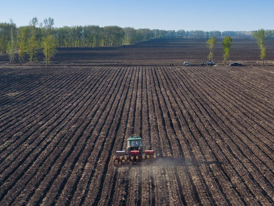
Black soil, considered the world’s most fertile for crops, once faced serious degradation in China – which hosts one of the world’s three largest black earth regions. During the 14th Five-Year Plan (2021–2025) period, over 400 million mu (26.67 million hectares) of black soil in China was restored, through no-till farming, straw return, and protective cultivation. Through these practices, the country has turned its farmland green and secured the future of its food supply.
China’s Black Soil Region is one of the world’s three largest black earth regions, primarily concentrated in the northeast plain. The unique climatic and hydrological conditions, coupled with the region’s vegetation, form the foundation for human accumulation, resulting in a deep and fertile layer of black soil. China’s Black Soil Region encompasses Heilongjiang, Jilin, Liaoning, and Inner Mongolia, where this expansive area covers 1.244 million square kilometers
Despite their relatively modest share in the global soil composition, black soils play a pivotal role, not just in supporting local communities but also in contributing to agricultural exports that nourish the global population. Remarkable yields are attributed to black soils, as evidenced by statistics indicating that over 50% of the global production of sunflower and small millet, 30% of wheat, 26% of soybean, and 16% of maize originate from black soils.
Recent research by University of Chinese Academy of Sciences has detailed the economic and ecological importance of conserving and managing these black soils.
The research points out that China’s black soils are renowned for their natural fertility, hold pivotal significance in global food production and play a crucial role in mitigating and adapting to climate change due to their excellent capacity for organic carbon sequestration.
However, black soils worldwide are subject to moderate to severe erosion due to the land use change, overuse of agrochemicals and high-intensity ploughing. Nearly 50% of organic carbon sequestration has been lost, resulting in nutrient imbalances, acidification, and biodiversity loss in black soil areas, severely compromising the capacity of food production and environmental sustainability.
China has ambitiously taken strides in the conservation and utilization of black soils, enacting its first law to protect black these invaluable resources, which have been promising. The research by the Chinese Academy of Sciences aimed to clarify the effect of China’s black soil conservation policies and projects on national grain supply security and greenhouse gas (GHG) emissions.
The research measures the contributions of grain production and GHG emissions in the black soil region in northeast China. Further, it analyzes the spatial and temporal characteristics of counties in advantage of grain production and GHG emissions from grain cultivation.
Through econometric analysis, this research evaluates the effectiveness of the pilot implementation of black soil conservation policies. Furthermore, it investigates the impacts of a comprehensive promotion of these policies, including optimization of grain structures, conservation tillage, organic soil cover, and nutrient management, on the future stabilization of national grain supply and the reduction of agricultural GHG emissions. The study results provide valuable information for Chinese agriculture as well as for global collaboration on black soil conservation and enhancement of agricultural land system management.