Normal view

  • ✇Eos
  • Hurricane Helene Ravaged Farmers’ Topsoil. They’re Still Fighting to Build It Back. Irina Zhorov
    This story was produced by Grist and the Food & Environment Reporting Network, a nonprofit news organization. Sign up for Grist’s weekly newsletter here. Will Runion’s 736-acre cattle and hay farm is tucked into a horseshoe bend of the Nolichucky River in northeast Tennessee. On the morning of Friday, September 27, 2024, he was in the middle of two big projects: building a riverfront campground on his land to bring in tourists and income, and cutting the last of the season’s hay. Hurrica
     

Hurricane Helene Ravaged Farmers’ Topsoil. They’re Still Fighting to Build It Back.

23 April 2026 at 12:52
Aerial view of muddy flood debris across fields in North Carolina

This story was produced by Grist and the Food & Environment Reporting Network, a nonprofit news organization. Sign up for Grist’s weekly newsletter here.

Will Runion’s 736-acre cattle and hay farm is tucked into a horseshoe bend of the Nolichucky River in northeast Tennessee. On the morning of Friday, September 27, 2024, he was in the middle of two big projects: building a riverfront campground on his land to bring in tourists and income, and cutting the last of the season’s hay. Hurricane Helene had been arcing up from Florida toward the Appalachian Mountains, carrying heavy rain, and the river was high. Even though the banks seemed to be holding, he decided to move some of his cows and equipment to higher ground.

But the river kept rising. At about 11 a.m., the brown water topped its banks. He and his fiancée, his son-in-law’s parents, and neighbors scrambled to salvage what farm equipment they could, but they were nearly trapped when the quickly expanding river flowed into a low-lying area behind where they were working, cutting them off from dry land.

By afternoon, the river had swollen to some 1,200 feet wide—nearly 10 times its usual size. It “looked just like a lake,” Runion said. Trees snapped in the swift current and neighbors’ barns, roofs, hay bales, and household debris swirled by. The water swallowed Runion’s hay equipment and sent the little white house he’d planned to use as the new campground’s office sailing across a field.

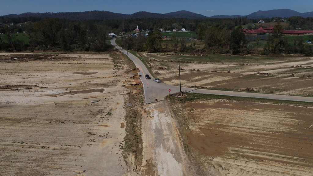
At around 8 p.m., the Nolichucky finally crested and started to recede. Runion found a third of his fields covered in debris, dead fish, and tomatoes from upstream vegetable growers. The flood had gouged two holes the size of football fields in his hay pastures, down to a depth of 12 feet. Other sections of the farm were buried in up to 8 feet of sand or silt.

(left) An overhead view of a farm shows a landscape washed over with sand. (right) An overhead view of a grassy landscape shows two patches of eroded dirt.
Flooding from Hurricane Helene brought massive damage to Will Runion’s farm, eroding the land in some places and washing up feet of sand on agricultural fields in other sections. Courtesy of Bryan LeBarre, via Grist

Helene dropped up to 30 inches of rain on southern Appalachia, causing historic flooding and landslides in parts of North Carolina, South Carolina, Tennessee, Georgia, Kentucky, and Virginia—a largely rural region where agriculture is a vital economic driver and cultural cornerstone. The mountains make it hard to spread out here, so farms tend to be small, and many growers use flood-prone bottomland because it is flat and fertile. But floods of this magnitude hadn’t hit here in generations. In North Carolina alone, Helene caused an estimated $4.9 billion in damage to the state’s agriculture sector. In Tennessee, agricultural losses were estimated at $1.3 billion. Thousands of farmers lost crops, tools, machinery, barns, buildings, animals, and fences.

“When you see 4 feet of sandy soils on top of your topsoil, you know that’s going to be a challenge. That was overwhelming.”

More than a year later, growers are also contending with the loss of something more vital, and more difficult to replace: their soil.

Runion knew immediately that his livelihood was ravaged. Without good soil, a farmer can’t farm. “When you see 4 feet of sandy soils on top of your topsoil, you know that’s going to be a challenge,” he said. “That was overwhelming.”

He sent drone footage of the damage to Forbes Walker, an environmental soil specialist with University of Tennessee Extension. “How do you fix this?” he asked.

“I don’t know,” Walker recalled thinking when he got Runion’s email. “How do we fix this?”

Over millennia, floods helped build the fertile land that farmers depend on. But today, climate change is driving more powerful and unpredictable storms. One study found that rainfall associated with Helene was 10 percent heavier due to man-made climate change. Research by the U.S. National Science Foundation suggests that what scientists call “100-year storms” will become three times more likely, and 20 percent more severe, over the next 50 years. What’s more, there’s little solid information about what happens to soil during a flood, or what to do when a farm’s soil is eroded or covered with material from elsewhere—its nutrients washed away and microbial communities disrupted. It’s a blind spot that is becoming more of a liability as storms like Helene become more common.

“None of us had ever seen anything like this before or responded to an emergency like that,” said Stephanie Kulesza, a nutrient and soil scientist at North Carolina State University. “And so we weren’t really prepared for recommendations to provide to producers.”


Soil can take thousands of years to form. Rock is weathered and slowly dissolves into smaller and smaller pieces. As dead leaves, animals, trees, and other plants decompose, they add organic matter and nutrients to the rock. Microorganisms establish themselves in the mix, driving nutrient cycling, aiding with decomposition, and stimulating plant growth; then worms and bugs, like beetles and ants, burrow in the mixture, aerating it. For soils to work well for agriculture, they need the right structure—airy enough to allow water to enter and move through, but not too quickly or too slowly—and sufficient biological and chemical richness, including nutrients like nitrogen, phosphorous, and potassium, to nourish crops.

Farmers use synthetic or natural fertilizers to ensure their soil has enough nutrients. They can also introduce practices like no-till—farming without plowing up the ground—to maintain the physical properties of their dirt. Topsoil, the rich, uppermost layer with the most available nutrients for crops, tends to make up less than a foot of the entire soil profile, but it’s crucial for agriculture.

A man stands in a rectangular dirt pit, about the same height as himself, which is surrounded by yellow caution tape.
Soil scientist Forbes Walker visits Will Runion’s farm in 2025, examining the deep sandy deposits left behind by Hurricane Helene. Credit: Raffe Lazarian/University of Tennessee Institute of Agriculture via Grist

Helene’s floodwaters either washed away significant topsoil or deposited new sediment on top of it on thousands of farms. Some, including one of Runion’s neighbors, saw their fields stripped down to bedrock, or river rock. Runion and others woke to pastures blanketed by feet of sand or stone.

When topsoil is washed away, the necessary nutrients for growing go with it. And when topsoil is covered with sand, farmers can’t get to it. Both scenarios can significantly alter the land’s usability. Topsoil can take decades or centuries to develop, and sand lacks both organic matter and the physical structure to hold water and nutrients. “These aren’t soils yet,” said Kulesza of what Helene left on Runion’s and other farmers’ land. “They are in their infancy now. The clock has been reset.”

Runion had cared for his soils, working to eliminate weeds, adding fertilizer to keep nutrient levels ideal, and lime to control pH. “They were our way of life,” Runion said. “They were our income.”

After the storm, from October to April, he removed debris, bulldozed sand off his fields to get closer to the topsoil, filled holes, and graded uneven land. Crews from the Federal Emergency Management Agency removed and shredded downed trees. He applied for government relief and received close to $1 million in state and federal aid. Runion said he could have easily used all of that money replacing equipment and paying for cleanup labor, fertilizer, and fuel, but he’s trying to stretch the money as much as possible.

By June, it was time to mow the fields that hadn’t flooded. He managed to put up enough bales of hay to feed his herd of 125 cattle, but not enough to sell. In a normal year, hay sales made up about a third of the farm’s income. With months of work behind him and his flooded land still too sandy and generally depleted, he realized the recovery would be a slog.

Runion returned to work on the campground, which he hoped would diversify the family’s earnings. The longer-term plan included a music venue and some hiking trails, and to host weddings and corporate events. After the storm, finishing it took on new urgency. He chose a new spot, about 450 feet upland from the river, and began clearing enough land for 45 camping sites.

One environmental soil specialist described the academic literature on flood-damaged soils as “thin.”

Runion also prepared a parcel of land for Walker, the extension soil specialist, to run tests that could guide his recovery. Last November, soon after the one-year anniversary of Helene, Walker showed me around Runion’s farm.

Working with students, Walker established four experiments over about 300 test plots. He’s looking at how different soil amendments—hay, wood chips, poultry litter, and a charcoal called biochar, to help the soil hold water and fertilizer; and Triple 19, a common plant food with equal parts nitrogen, phosphorous, and potassium—affect the growth of wheat and fescue grasses.

When I visited, some of the plots remained mostly bare while, in others, tufts of green had sprouted. “We actually got some stuff to grow,” Walker said.

He described the academic literature on flood-damaged soils as “thin.” While some research and case studies exist on how agricultural soil recovers after a flood, there are few systematic investigations like the one Walker is conducting—on what works, and what does not—particularly in Appalachia, where floods of this magnitude have been historically rare.

When so-called atmospheric rivers spawned devastating floods in the Pacific Northwest and southwestern British Columbia in 2021, Aimé Messiga, a Canadian soil research scientist at the Agassiz Research and Development Centre, found a similar “scarcity of data.” He conducted a detailed review of the existing research and concluded that there was limited long-term monitoring, little understanding of how floods affect nutrients and microorganism communities in the soil, and uncertainties about what the actual impacts of floods on agriculture and crops are. Complicating everything is the variability between different farms, soils, and crops.

“You need decades of accumulated data in order to be able to predict what will happen. We don’t have those data.”

“You need decades of accumulated data in order to be able to predict what will happen,” Messiga said. “We don’t have those data.”

Today, some researchers are attempting to replicate flood conditions in labs to better understand, but field work is rare, Messiga said. There’s little money for it—and in the U.S., the Trump administration has cut funding for climate-related research. In addition, “many among us still look at these events as random,” Messiga said. “They’re not random. They will keep occurring.”


Since 1980, 45 flooding events have caused damages over $1 billion each in the U.S., with more than half of those occurring in the past 15 years. In 2024, flooding in the upper Midwest drowned crops. Repeat events in central California damaged agricultural operations from winter 2022 to spring 2023. Flooding along the Mississippi River in 2019 reduced crop planting by millions of acres. There also have been numerous smaller or more localized floods. One study found nearly 75,000 flash floods in the contiguous U.S. from 1996 to 2017, with increasing frequency in the past 22 years. Flooding frequency and strength is predicted to rise in the years to come due to climate change—a warmer atmosphere holds more moisture and leads to stronger rain events—and poor land-use management.

Scientists are also starting to study a new type of event, called “weather whiplash,” when sudden changes occur from one extreme to another, amplifying the effects of the disaster. In Texas in 2025, a flood came after prolonged drought, causing widespread destruction.

For farmers, the effects of flooding on soil may linger for years after the disaster. In 2011, the Missouri River flooded states in the Upper Midwest, including thousands of acres of farmland. Fields were swamped for months with up to 20 feet of water. When the water finally receded, those fields were covered with anywhere from 2 to 20 feet of sand; other fields had washed out holes up to 70 feet deep. It looked like the surface of the moon, said John Wilson, a now-retired educator and agricultural expert who served Burt County, Nebraska, which was particularly hard-hit. “It was just bare soil,” he said. “There was no crop residue whatsoever.”

Wilson led teams that sampled the soil and helped farmers build back. He found that levels of nitrogen and organic matter were low in flooded soils, and fertility suffered when farmers planted their crops. Over about five years, fertility generally improved, but not everywhere. “If you went out today and did a yield map, you could still tell exactly where the erosion was because those areas are not as productive,” Wilson said.

Yield is money for farmers, who already navigate thin margins and, often, years without any profit at all. North Carolina’s strategic plan for agriculture recently enumerated just how thin: Of the state’s “42,500 farms, only 8,000 produce annual gross sales that exceed $100,000 annually. The overwhelming majority … some 23,400, gross less than $10,000 in sales, with only around 40 percent of the farms in the state having a positive net income in 2022.”

As floods increasingly wreck farmland, more researchers are starting to focus on understanding the effects of the floods and how to address them. Most of that work is happening in Asia, Messiga said. But a study in coastal North Carolina, where hurricanes regularly land, found that after a storm there was less organic matter in the soil, including carbon, and a disruption of microbial activity and nutrient cycling. The ground also absorbed water less readily.

Coastal flooding is also driving saltwater into the soil of farmland, making it more saline and unable to sustain crops. A North Carolina State University team has been developing test kits for farmers to sample the salinity of their soils, as well as a set of recommendations for keeping their soil viable. Such local work is important because soils vary greatly from place to place, and findings are not often easily transferable.

A white agricultural tent lies on the ground, having been wiped out by a flood. Green trees line the area.
Nicole DelCogliano’s farm near Asheville, North Carolina, was wiped out almost entirely by floods from Hurricane Helene in 2024. Courtesy of Nicole DelCogliano via Grist

For now, in the wake of Helene, farmers are relying largely on trial and error to build back what was lost. Nicole DelCogliano has been farming vegetables, flowers, and livestock with her husband on 50 acres on the South Toe River, near Asheville, North Carolina, for 25 years. Helene washed away her barn, tractor, and other infrastructure. Of her 6 acres of vegetable fields, one was covered with several feet of sand, another got a foot, and a third field suffered extensive erosion.

“Our entire operation was wiped out, essentially,” she said.

“It’s not something that can be fixed overnight. This is a long process.”

With the help of some friends with tractors, DelCogliano cleared her main field and spread compost and lime on everything. “There was a mix of guidance about what you should do, like should you disturb the soil, should you not?” she said. “At an instinctual level, we just felt like we got to get the soil covered, we got to get something in the ground.” They sowed rye, a dependable cool season grass, as a cover crop, to protect the soil from erosion and add nutrients.

Karen Blaedow, an agricultural educator in Henderson County, North Carolina, said farmers should expect to put in at least three years of cover cropping before they see results in their soil. “It’s not something that can be fixed overnight,” she said. “This is a long process.”

In the spring following the flood, DelCogliano spread various amendments on her least-damaged field, including compost, lime, biochar, and blood and bone meal, which provide nitrogen and phosphorus, respectively. After all that, she and her husband seeded crops.

Their new vegetables came in about two weeks later than normal, but the season was more productive than ever, even though they grew on just 4 instead of 6 acres—“which is pretty amazing,” she said. “When we first started harvesting crops [after Helene], we didn’t yet have power at the farm. I had to dig one of our sinks out of a bank and bleach it and clean it and drag it up to the new barn—that we barely got a roof on—to wash and pack for that first [farmers] market.”

She doesn’t really know what made the year so productive. They planted more intensively to account for the smaller acreage and were able to harness their years of expertise to restart their operation basically from scratch. She also attributes the relative health of her soil to years of organic practices. “We’re dirt farmers,” she said. “Our primary job is to tend the dirt. Because that’s the basis of everything.”

Some farmers who’ve seen good harvests may have gotten a little lucky. Rather than sand, floods dumped silt. Even Runion got silt deposits in one section of his farm. Unlike the sand, the silty layers carry nutrients and create a positive growing environment. “We have a producer we work with and he said it’s the most fertile soil that he’s had in decades,” said Emine Fidan, a biosystems engineering and soil science researcher at the University of Tennessee, who’s also working on Runion’s farm. “And he said it grew the sweetest corn he’s ever had. It was growing just beautifully.”


Runion didn’t plant anything until this past fall. He prepared about 65 acres of the 220 that were underwater. It was slow going; he used a disking machine to till his land but had to stop often to clear sticks and trash and to grade out low spots. He mixed in mulch and planted oats, wheat, and fescue. Walker drove me past one of the fields and it still looked sandy, the grasses just a pale green shadow on the tan land. Runion said the greenery was “struggling to have any vigor about it.” He won’t know for sure how well or poorly the grasses do until spring, their peak growing season.

He considered planting more acreage but decided to wait and see what he learned from Walker’s trials. “It’s a process, and the knowledge we’re gaining there will help on the whole rest of it, too,” Runion said.

This spring, Walker’s team will measure the biomass in each plot as well as the quality of the crop, including how much protein it has and its digestibility. They’ll also be evaluating the soil itself, including its ability to hold water, to determine if any of the treatments improved the structure of the sandy dirt.

One farmer thinks the hay he’ll get in the coming years will be lower-yielding, lower-quality, and will cost more to produce due to the extra prep time, new seeds, and fertilizers.

Preliminary results suggest that, in plots where they put down mulch, the grasses are growing better than in plots with other amendments. The woody debris is reducing erosion and seeds are germinating well and standing up in the rough matrix. Spreading this kind of mulch isn’t an obvious solution, Walker said: Wood chips are a carbon-rich material, but as they break down in the soil they consume nitrogen, which can lead to a deficiency for the crops. But this mulch had sat in piles and started to decompose before it was applied to Runion’s fields, which made it less likely to cause these problems.

Runion had asked FEMA to leave the piles of wood chips on his farm rather than remove them like they normally would. Walker is looking for solutions to the soil problem that not only work but are also accessible. Have a mountain of mulch? Put it to work. Have nearby chicken houses? Maybe their nitrogen-rich manure can help revive flooded fields. His hope is that his team’s research can provide some guidance to farmers who find themselves in similar situations in the future. “I think it will have broad implications for a number of different crops,” including vegetables, Walker said.

Meanwhile, Runion is coming to terms with his situation. He thinks the hay he’ll get in the coming years will be lower-yielding, lower-quality, and will cost more to produce due to the extra prep time, new seeds, and fertilizers. He used to sell a lot of square bales, which tend to contain high-quality grasses and fetch a higher price, but he doesn’t expect to be doing that for a while. He’d initially hoped to have his land back in shape in a year or two. “Now it’s a four- to five-year [plan], I think,” Runion said. “It has been frustrating, and exhausting, too.”

He’s still optimistic, though. On my visit, I watched him grade out the new campground in a large dump truck. Freshly exposed red soil lay open to the sky. He thinks he can get the campground open by late summer or early fall. Over time, he hopes, it will be a more lucrative, and more sustainable, source of income. “The farm is really beautiful,” Runion said. “It still has a lot to offer.”

—Irina Zhorov, Grist

This article originally appeared in Grist at https://grist.org/extreme-weather/hurricane-helene-ravaged-farmers-topsoil-theyre-still-fighting-to-build-it-back/.

Grist is a nonprofit, independent media organization dedicated to telling stories of climate solutions and a just future. Learn more at Grist.org

  • ✇Eos
  • Sand Demand Outpaces Sustainable Extraction Kimberly M. S. Cartier
    Research & Developments is a blog for brief updates that provide context for the flurry of news that impacts science and scientists today. Sand is the most exploited solid natural resource on Earth. It has been integrated into how we build homes, roads, buildings, and bridges as well as how we protect coastal infrastructure from rising seas. Sand underpins nearly every aspect of modern infrastructure and economics, plays crucial roles in supporting ecosystem biodiversity, and literal
     

Sand Demand Outpaces Sustainable Extraction

12 May 2026 at 13:48
Colorful boats filled sit side by side on a sandy bank, each with a line of trucks waiting to fill it with more extracted sand.

Research & Developments is a blog for brief updates that provide context for the flurry of news that impacts science and scientists today.

Sand is the most exploited solid natural resource on Earth. It has been integrated into how we build homes, roads, buildings, and bridges as well as how we protect coastal infrastructure from rising seas. Sand underpins nearly every aspect of modern infrastructure and economics, plays crucial roles in supporting ecosystem biodiversity, and literally shores up rivers and coasts.

A new report from the United Nations Environment Programme (UNEP) found that we are using 50 billion metric tons (50 trillion kilograms) of sand per year. As global development and industrialization expand, demand for sand in the building sector is expected to rise 45% by the year 2060, outpacing current efforts to sustainably harvest it. The report’s authors urge countries to establish sand as a strategic national asset and develop policies for sustainable extraction.

“Sand is sometimes referred as the unrecognized hero of development, but its essential role in sustaining the natural services on which we depend is even more overlooked,” Pascal Peduzzi, director of the UNEP Global Resource Information Database Geneva, said in a press release about the report. “Sand is our first line of defence against sea level rise, storm surges, and salination of coastal aquifers—all hazards exacerbated by climate change.”

Sand Wanted: Dead or Alive

Dead sand, or sand that has been extracted from its natural environment, is a key component in building materials like concrete and asphalt. Communities around the world use sand in water filtration systems, providing clean water for drinking and agricultural use. And although a transition to clean energy sources is necessary to curb the effects of climate change, many of those sources also depend on sand: solar panels require glass made from high-purity silica sand, and wind turbines, hydroelectric dams, and nuclear power plants all require concrete.

A copse of mangroves grows on a sandy shore. Dozens of iguanas lounge on the sand.
Mangroves, one of the most important coastal trees, can grow in sand. Credit: Diego Parra

Sand also plays a critical role in natural ecosystems. It is home to a wide array of critters from crabs, sharks, and turtles to microorganisms like bacteria and fungi. It supports the growth of corals, mangroves, and seagrasses that in turn support even more marine creatures. It is a key component of healthy soil and aids in surface drainage. It guides river evolution and acts as flood buffer and storm barrier. It also provides local economic benefits via tourism.

These are among the values of sand when it is left alone and unused, called “alive” sand. The UN report notes that these benefits are typically of greater value over time than if sand is dredged and used. But because these benefits are hard to see, they are often overlooked when nations calculate the value of their sand resources.

A Sustainable Sand Future

Despite sand’s importance whether dead or alive, the report notes that few countries have established sand as a strategic national asset or have developed strategies for sustainable extraction. At the current pace, humans are extracting sand from the natural environment at a faster pace than it is being replenished by geologic processes.

 
Related

•  Read the Report: Sand and Sustainability: An Essential Resource for Nature and Development
•  Track Global Sand Dredging: Marine Sand Watch
•  Dig Into the Details: Grains of Sand: Too Much and Never Enough
 

What’s more, the UNEP’s Marine Sand Watch tool shows that about half of sand dredging companies are operating within marine protected areas, accounting for about 15% of the volume of dredged sand. This practice, the report notes, is potentially trading in sand’s long-term benefits for short-term gains.

The UN report recommends a few actions to protect the long-term availability of sand as a natural resource, including:

  • Recognizing sand as strategic national asset, establishing national inventories, and creating long-term regional planning groups that consider sand as an essential resource for resilience;
  • Establishing circularity and recycling of building materials, especially in areas of conflict and natural disasters;
  • Strengthening environmental protection practices, and codifying international frameworks to strengthen accountability along the supply chain, including increased transparency about extraction; and
  • Integrating sand-related biodiversity and social risks into financial decisionmaking and governance.

“Over-reliance on short-term economic metrics risks obscuring, and further impacting, the geological and ecological processes that take centuries to form and may not be restored once critical thresholds are crossed,” the report states. “What is hardest to measure may be precisely what sustains both nature and human societies over the long term. The challenge ahead is not only to manage extraction, but to recognise and balance the full spectrum of sand’s values.”

—Kimberly M. S. Cartier (@astrokimcartier.bsky.social), Staff Writer

These updates are made possible through information from the scientific community. Do you have a story about science or scientists? Send us a tip at eos@agu.org.

A photo of a hand holding a copy of an issue of Eos appears in a circle over a field of blue along with the Eos logo and the following text: Support Eos’s mission to broadly share science news and research. Below the text is a darker blue button that reads “donate today.”
Text © 2026. AGU. CC BY-NC-ND 3.0
Except where otherwise noted, images are subject to copyright. Any reuse without express permission from the copyright owner is prohibited.
  • ✇Eos
  • Rocket Launches and Reentries Harm Earth’s Ozone Layer Sarah Stanley
    Source: Earth’s Future The space industry is surging. In coming years, nearly 10,000 spacecraft are slated to launch into low-Earth orbit for a variety of purposes, such as global surveillance, space tourism, and satellite “megaconstellations” providing internet service. Rocket engine exhaust, as well as the burnup of inactive satellites and rocket parts reentering Earth’s atmosphere, releases a suite of pollutants. These chemicals have long been considered to pose little threat to our cl
     

Rocket Launches and Reentries Harm Earth’s Ozone Layer

8 June 2026 at 13:23
This image shows a rocket launching into a blue sky from its launchpad. A bright white and orange tail is emitted from the bottom of the rocket, transitioning into cloudlike billows of gas closer to the ground. A body of still water is in the midground, and grasses and shrubs are in the foreground.
Source: Earth’s Future

The space industry is surging. In coming years, nearly 10,000 spacecraft are slated to launch into low-Earth orbit for a variety of purposes, such as global surveillance, space tourism, and satellite “megaconstellations” providing internet service.

Rocket engine exhaust, as well as the burnup of inactive satellites and rocket parts reentering Earth’s atmosphere, releases a suite of pollutants. These chemicals have long been considered to pose little threat to our climate, given the historically small size of the space industry. Now, the sector’s rapid growth will send its emissions skyrocketing—but scientists don’t yet have a clear picture of the environmental ramifications.

An analysis by Vliex et al. of rockets launched in 2022 revealed that spaceflight depletes the ozone layer and contributes to global warming, with a significant portion of this ozone loss attributable to nitrogen oxide emissions released by objects reentering Earth’s atmosphere.

The researchers calculated emissions from all 186 rockets launched in 2022, as well as all 472 objects—with a combined total mass of nearly 5,000 tons—that reentered the atmosphere that year. They conducted computational simulations of each launch’s trajectory and emissions at various altitudes up to 100 kilometers, and they calculated emissions released by object reentry. They also accounted for the effects of chemical reactions that occur in rocket exhaust plumes, which alter emissions’ chemical composition.

Incorporation of the calculated emissions into GEOS-Chem, a computational model of atmospheric chemistry, revealed their ozone-depleting and Earth-warming effects, with reentry emissions identified as playing a key role in ozone depletion. The researchers found that accounting for plume reactions reduced the estimated effects of spaceflight emissions, highlighting the value of considering plume chemistry in future assessments.

The analysis also underscored the varying effects of different rocket fuel types. Solid-state fuels, used recently in rocket boosters for NASA’s Artemis II mission to return astronauts to the Moon, appeared to cause the greatest amount of ozone depletion relative to propellant mass, while rocket-grade kerosene caused the greatest amount of warming.

On the basis of their findings, the researchers call for further research into reentry emissions and rocket plume chemistry as the space industry continues to expand and evolve. (Earth’s Future, https://doi.org/10.1029/2025EF007795, 2026)

—Sarah Stanley, Science Writer

The logo for the United Nations Sustainable Development Goal 3 is at left. To its right is the following text: The research reported here supports Sustainable Development Goal 3. AGU is committed to supporting the United Nations 2030 Agenda for Sustainable Development, which provides a shared blueprint for peace and prosperity for people and the planet, now and into the future.
A photo of a telescope array appears in a circle over a field of blue along with the Eos logo and the following text: Support Eos’s mission to broadly share science news and research. Below the text is a darker blue button that reads “donate today.”
Citation: Stanley, S. (2026), Rocket launches and reentries harm Earth’s ozone layer, Eos, 107, https://doi.org/10.1029/2026EO260183. Published on 8 June 2026.
Text © 2026. AGU. CC BY-NC-ND 3.0
Except where otherwise noted, images are subject to copyright. Any reuse without express permission from the copyright owner is prohibited.
  • ✇Eos
  • Chemical Companies Are Churning Out New PFAS. Where in the World Are They Ending Up? Grace van Deelen
    Seeking Solutions to PFAS Pollution Chemical Companies Are Churning Out New PFAS. Where in the World Are They Ending Up? The Persistence of PFAS A Peculiar Polymer Paired with Sunlight Could Remove PFAS Tracing the Path of PFAS Across Antarctica Pollution Is Rampant. We Might As Well Make Use of It. On a rocky archipelago in the North Atlantic Ocean, staff at the Faroese Environment Agency and the Faroe Marine Research Institute regularly sample tissues from the North At
     

Chemical Companies Are Churning Out New PFAS. Where in the World Are They Ending Up?

1 May 2026 at 03:55
A large fjord with rocky, snow-covered mountains in the background

On a rocky archipelago in the North Atlantic Ocean, staff at the Faroese Environment Agency and the Faroe Marine Research Institute regularly sample tissues from the North Atlantic long-finned pilot whales that roam the waters around the islands. The archive of these samples stretches back to the 1980s and has helped researchers determine the reach of human-made contaminants in the remote marine environment.

Jennifer Sun is one of those researchers. Sun studies PFAS—per- and polyfluoroalkyl substances, commonly known as “forever chemicals”—at Harvard University and is the lead author of a recently published study that analyzed how these toxic chemicals have accumulated in pilot whale tissue over the past 2 decades.

Using samples of whale tissue collected between 2001 and 2023, Sun and her colleagues measured a parameter called bulk extractable organofluorine, which shows the overall amount of organofluorine-containing chemicals (including PFAS) in the tissue. They then used a more targeted analysis able to confirm the identity of 28 specific chemicals out of thousands of possible PFAS formulations.

Three chunks of red and pink whale tissue on a white plastic surface
The pilot whale tissue showed an expected decrease in the concentrations of older PFAS but an unexpected scarcity of newer PFAS chemicals. Credit: Jennifer Sun

The study’s results showed an expected decrease in the concentrations of older PFAS but an unexpected absence of newer PFAS chemicals. This anomaly could be indicative of an emerging question in PFAS research: Where are the newest PFAS going?

Prolific PFAS

There are two general categories of PFAS. The first includes legacy PFAS such as perfluorooctanoic acid (PFOA) and perfluorooctane sulfonic acid (PFOS). Chemical manufacturers produced these compounds in the 1970s, 1980s, and 1990s for products including nonstick cookware and food packaging and in industries such as fabric waterproofing, industrial manufacturing, and firefighting.

Legacy PFAS were phased out in the early 2000s, and novel PFAS were made to replace them. The term “novel” is independent of chemical properties and instead refers to when the chemicals’ production began, though novel PFAS typically have formulations meant to reduce their persistence in the environment. For example, many novel PFAS molecules have shorter chains of fluorinated carbons than their legacy counterparts.

Novel PFAS include possibly millions of different chemical structures, and their production and use are increasing globally.

A diagram shows the general structure of a PFAS molecule, which includes a “head group” connected to a chain of fluorinated carbon atoms.
A generic PFAS molecule includes a compound head connected to a tail of fluorinated carbons. Older PFAS generally have longer tails (seven or eight carbons) than newer ones. Credit: Mary Heinrichs/AGU, after https://bit.ly/pennstate-ext-pfas

In the United States and elsewhere, regulatory structures that limit PFAS production target specific chemicals, such that every new formulation by a company must be tested individually before restrictions are put in place. With companies continually conjuring new PFAS formulations—which environmental advocates often call “regrettable substitutions” for their sometimes harmful effects—understanding the fate and transport of novel PFAS is difficult and time-consuming. Research on the behavior of specific PFAS may be a drop in the bucket when millions of potential PFAS, with millions of potential behaviors, pose current and future risks to people and the environment.

Scientists like Sun are determined to untangle how the fate of these new chemicals differs from their predecessors. As Sun expected, the phaseout of legacy PFAS was reflected in the pilot whale tissue she tested. These results are good news; they clearly show that the bans on legacy PFAS are working.

“We’re still finding [older] compounds, but clearly, they are no longer as abundant in the environment as they used to be, which is a positive,” said Bridger Ruyle, an environmental engineer at New York University who studies PFAS and assisted Sun and her coauthors in deciding which methods to use for the new study.

But Sun and her colleagues also expected an overall increase in concentrations of novel PFAS—after all, production of these chemicals is higher than ever, and researchers finally had the analytical tools to catch them.

“The inference is, if it’s not in the whales, and it’s not in the ocean…where is it?”

That wasn’t what they found. Instead, all but two of the emerging PFAS they tested for were virtually nowhere to be seen in the whale tissue, leaving the scientists leading the study to wonder where novel PFAS were accumulating or if instrumentation was limiting their detection.

“We do know that the novel PFAS are being produced, which means they’re going somewhere. Where they are, and how exposed people and other wildlife are, is not as clear,” Sun said.

“The inference is, if it’s not in the whales, and it’s not in the ocean…where is it?” asked Elsie Sunderland, an environmental scientist at Harvard University and coauthor of the new study.

Sun and Sunderland’s question—asking where novel PFAS are going—is one scientists are probing from multiple angles. Those who study particle transport are asking how novel PFAS might travel through Earth’s water and air. Those on the chemistry side of the investigation are deducing how novel PFAS might break down. And those who monitor environments are looking for traces of novel PFAS in various corners of Earth.

The answers to their questions have direct, practical implications for human and environmental health and could indicate whether a growing proportion of harmful PFAS may be ending up in close proximity to humans—where we work and eat and breathe.

A Toxic Legacy

The chemical properties of PFAS have made the chemicals useful since the 1940s. These same properties also make them highly persistent—the most durable types may not break down in the environment for several thousand years.

PFAS are linked to certain cancers and other human health harms. Much of the available data linking PFAS to poor health come from analyses of legacy PFOA and PFOS. They show an association between increased exposure to these chemicals and altered immune and thyroid function, liver and kidney disease, reproductive system disruptions, and more.

Chemical manufacturers phased out production of legacy PFAS after scientific evidence emerged associating PFAS and human health harms, businesses began to lose money in massive lawsuits, and regulations tightened. Novel PFAS were intended to show properties similar to legacy PFAS but were meant to break down more easily in the environment (lower persistence) and accumulate less easily in living tissue (lower bioaccumulative ability), though studies have shown mixed results about whether novel PFAS are actually safer for humans or break down more easily.

Because PFAS production data are often proprietary, scientists who study PFAS, like Sun, must rely on partial inventories of PFAS production or reverse-engineer those numbers from observations in the environment.

“We call it chemical Whac-A-Mole.”

Without a clear list of the chemical structures of novel PFAS, scientists don’t always have the analytical standards necessary for routine detection. And once scientists do understand the behavior of a PFAS chemical, it may be quickly replaced by another, unknown alternative. “We call it chemical Whac-A-Mole,” Sunderland said.

Legacy PFAS tend to have a high affinity for water and typically end up in the ocean, the place scientists refer to as the chemicals’ “terminal sink.” Many legacy PFAS also entered the ocean through atmospheric transport such as rain or snow. But because of the sheer number of chemical formulas and the chemical differences between legacy and novel PFAS, the pathways that novel PFAS take through the environment are less clear.

Tracking the movement and accumulation of novel PFAS in the environment is crucial for understanding how these chemicals may affect ecological and human health.

Still, the science is inconclusive about whether novel PFAS are moving or accumulating differently than their legacy counterparts, whether they have a different terminal sink, and where that terminal sink may be.

Close to Home

One possible answer to the question of the missing novel PFAS may have to do with geography. The chemicals may not have reached pilot whales in the Faroes because something about the new chemistry has led them elsewhere in the environment. To Sun, evidence suggests “that a lot of these novel PFAS, which we know are being produced, may not be transporting out into this more remote environment either at all or as quickly.”

Novel PFAS might be accumulating closer to their sources—and closer to us. “It may simply be that some of the replacement PFAS don’t make it all the way out into the open ocean. But if they are still in the terrestrial environment and the near-coastal environment, then wildlife and people who live close to the sources can be exposed, said Frank Wania, an environmental chemist at the University of Toronto Scarborough.

For example, one study monitored PFAS in coastal beluga whales in Canada’s St. Lawrence Estuary, relatively close to human communities and PFAS manufacturing sources. The study showed increasing concentrations of unregulated novel PFAS in whale tissue from 2000 to 2017, while concentrations of legacy PFAS declined.

The suggestion that novel PFAS are accumulating close to human communities is supported by measurements of PFAS in human tissue, too. Studies show that a high proportion of detectable organofluorine chemicals in human tissue are increasingly unidentifiable, suggesting that some of the novel PFAS production “is in us,” Sunderland said.

Far and Away

Though there are some indications that novel PFAS may be retained closer to human communities, there are also reasons to think some novel PFAS chemistries have resulted in substances that can actually travel farther and more easily than their legacy counterparts.

Anna Kärrman, an environmental chemist at Örebro University in Sweden, said that some novel PFAS may be more easily transported in the environment: “The more novel chemistries are increasing the properties of being very mobile in water, very mobile in the atmosphere, and not necessarily very bioaccumulative.”

The mobility of novel PFAS was on full display in a 2020 study that Sunderland coauthored, in which researchers reported detecting hexafluoropropylene oxide-dimer acid, a novel PFAS chemical more commonly known as GenX, in the Arctic for the first time. GenX, produced by chemical manufacturer Chemours, was meant to replace the legacy compound PFOA. The 2020 study suggested GenX “has already moved quite a bit,” said Rainer Lohmann, a marine geochemist who leads the STEEP (Sources, Transport, Exposure and Effects of PFAS) Center at the University of Rhode Island.

A pulley system mounted on a red beam pulls a small envelope filled with water along a string.
A pulley system mounted on a red beam pulls a small envelope filled with water along a string. Credit: Thomas Soltwedel

The 2020 study also found higher concentrations of PFAS in the Arctic Ocean’s surface water, suggesting that the atmosphere was a particularly important transport pathway for chemical transport. This idea is supported by studies of High Arctic ice caps, which experience contamination only from atmospheric sources, and polar bear tissue. Atmospheric transport of novel PFAS is a subject “at the edge” of PFAS research, Sunderland said.

Wherever researchers look, they’re finding that atmospheric transport is an important pathway by which some PFAS, especially PFAS precursors—chemicals that break down in the environment and become PFAS (either novel or legacy)—move. One idea called the PAART (precursor atmospheric and reaction transport) theory was developed by Scott Mabury, an environmental chemist at the University of Toronto, and others. The PAART theory proposes that many of the harmful PFAS that end up in the most remote parts of Earth are the result of the breakdown of volatile precursor PFAS that have traveled in the atmosphere.

According to Lohmann, atmospheric transport means the ocean remains a terminal sink because many novel PFAS transported in rain or snow will ultimately be deposited in the ocean.

In this scenario, the question of why novel PFAS are not bioaccumulating in Faroese pilot whales remains a mystery. While Lohmann suggests the novel compounds simply don’t accumulate in living tissue, Sunderland isn’t sure that’s the whole story: “As apex predators, the whales are sentinels for what is available and being taken up from the ocean,” she wrote in an email. “Since we don’t see [novel PFAS], it seems unlikely there are large quantities of these chemicals present.”

Profuse PFAS

Another possible explanation for the surprising results of Sun’s whale study could be that there’s just a lag; that is, novel PFAS will end up in Faroe Island pilot whales someday but haven’t yet. Chemicals that could eventually end up in the ocean may be temporarily trapped in soils or recycled back into terrestrial ecosystems via sea spray aerosols, for example.

“The delay we are seeing in the ocean response may in fact be [PFAS] precursors being retained in source zones,” Sunderland wrote in an email. These chemicals may be “taking a really long time to be transformed into more mobile compounds.”

In their pilot whale study, Sun and her colleagues modeled the transport of PFAS to the subarctic and found a 10- to 20-year lag existed between the production of a legacy PFAS compound and its detection in whale tissue. We’re still within that range for many novel PFAS. Sun said she would have expected them to show up in pilot whale tissue by now if they behaved like their legacy counterparts, though it’s possible that it has taken time for the volume of novel PFAS production to ramp up, increasing the time it would take for the substances to be detected in tissues.

A group of whales’ fins breach the surface of the water.
The anomaly documented in the pilot whale study has led researchers to call for more investigation (and perhaps greater regulation) of novel PFAS. Credit: Bjarni Mikkelson

Still, the number of possible novel PFAS chemistries—again, there could be several million different compounds—makes it difficult to generalize how these new substances are, as a group, moving through the environment. “Because the exact structures of all [novel] PFAS remain unknown, some compounds may simply not be captured by the methods used,” Heidi Pickard, an environmental engineer at the consulting firm Ramboll and coauthor on the new whale study, wrote in an email.

Another reason novel PFAS are harder to study is that companies release lower concentrations of more kinds of the chemicals, rather than the “monstrously high” emissions of some legacy PFAS in the 1970s–1990s, noted Mabury, who was not involved in the new pilot whale study.

A New Regulatory Approach

According to Sun and Sunderland, cataloging differences between novel and legacy PFAS misses the broader point: We simply need to produce less PFAS. We’ve known for decades that PFAS harm human health, and some scientists have even argued that humans’ continual production and release of novel chemical compounds could drive Earth beyond a “safe operating space.”

“Researchers are critical for exposing the problem. But that, to me, is not the central issue here. The central issue here is a societal issue.”

Where scientists probe next may be less urgent than how policymakers decide to tackle the PFAS problem, Sunderland said: “Researchers are critical for exposing the problem. But that, to me, is not the central issue here. The central issue here is a societal issue.”

Chemical manufacturers are actively creating novel PFAS all the time. Kärrman, for example, has noticed patent applications for PFAS compounds with chemistries that “are nothing like we have seen before” that may start entering our environment in 5 or 10 years.

To Kärrman, that’s a reason for governments to push for chemical regulation based on properties such as persistence and bioaccumulation, rather than the chemical-by-chemical formula used in most countries, including the United States.

Such an approach has gotten traction in Europe via a proposal by the European Chemicals Agency to restrict the entire class of PFAS chemicals. The proposal is still under evaluation, and a final decision is expected by the end of the year.

In the United States, PFAS regulation and remediation are a key aspect of the Trump administration’s Make America Healthy Again movement, according to the EPA, and the federal government and some states already limit the concentrations of individual PFAS in drinking water. However, the EPA also said it planned to weaken some of those limits last year.

“We’re in a cycle of picking these regrettable alternatives [to legacy PFAS] and then figuring out that it was regrettable decades later,” Sunderland said. “We’re never going to catch up using this chemical-by-chemical approach.”

—Grace van Deelen (@gvd.bsky.social), Staff Writer

Citation: van Deelen, G. (2026), Chemical companies are churning out new PFAS. Where in the world are they ending up?, Eos, 107, https://doi.org/10.1029/2026EO260136. Published on 30 April 2026.
Text © 2026. The authors. CC BY-NC-ND 3.0
Except where otherwise noted, images are subject to copyright. Any reuse without express permission from the copyright owner is prohibited.
  • ✇Eos
  • The Genesis Mission Needs Hydrology: Here’s How to Incorporate It Amobichukwu C. Amanambu and Jonathan Frame
    Every chip fabricated in a semiconductor plant needs ultrapure water. Most nuclear reactors need water as a coolant and neutron moderator. Every artificial intelligence (AI) data center drinks between 1 million and 5 million gallons of water a day, with thirst often peaking during drought. Water runs through every technology priority the United States has named, yet the word does not appear once in “Launching the Genesis Mission,” an executive order (EO) released in November 2025. As describ
     

The Genesis Mission Needs Hydrology: Here’s How to Incorporate It

Satellite image of The Dalles Google data center and the adjacent Columbia River.

Every chip fabricated in a semiconductor plant needs ultrapure water. Most nuclear reactors need water as a coolant and neutron moderator. Every artificial intelligence (AI) data center drinks between 1 million and 5 million gallons of water a day, with thirst often peaking during drought.

Water runs through every technology priority the United States has named, yet the word does not appear once in “Launching the Genesis Mission,” an executive order (EO) released in November 2025. As described in the EO, the Genesis Mission is a “dedicated, coordinated national effort to unleash a new age of AI-accelerated innovation and discovery that can solve the most challenging problems of this century.”

Led by the Department of Energy (DOE), the initiative aims to build an integrated AI framework that would harness federal scientific datasets to accelerate breakthroughs in advanced manufacturing, biotechnology, critical materials, nuclear fission and fusion energy, quantum information science, and semiconductor development. The scope of the mission is comparable to that of the Manhattan Project.

Since the announcement, the DOE has listed “Predicting U.S. Water for Energy” among its 26 Genesis Mission Science and Technology Challenges. The project is also soliciting proposals in three water-related focus areas.

This framework provides a foothold for hydrology in the Genesis Mission, but it is scoped narrowly around water as a supply variable for energy production.

In reality, water is a crosscutting constraint that will help determine whether the mission’s priorities translate into deployable outcomes. The hydrology community now has a seat at the table, and if it moves first and positions water security as one of the “most challenging problems of this century,” the Genesis Mission can become the sandbox in which AI reshapes how the country measures, models, and manages water.

Making this happen will require that the DOE and the Office of Science and Technology Policy charter a hydrology workstream inside the Genesis Mission, with interagency delivery involving the U.S. Geological Survey (USGS), NOAA, the Bureau of Reclamation, the EPA, and partners at state, regional, and community levels. Here is what we think that workstream should look like:

Illustration with “Genesis AI Platform” as a hub and seven mission-related components as spokes.
A water-centric Genesis Mission architecture supports seven hydrological components that both feed into and receive decisions from the Genesis AI platform. Each component maps to a section of this article. Credit: Amobichukwu C. Amanambu. Click image for larger version.

While the existing challenges reflect some of these components, others will require coordinated effort from the hydrology community to bring into the Genesis Mission’s scope.

Build the Water Corpus Genesis Will Need

The Genesis Mission EO instructs the DOE to create an American Science and Security Platform to provide the public, scientists, agencies, and policymakers access to crucial scientific datasets.

The good news is that accessible water data systems already exist across several federal agencies and academic research centers. The USGS National Water Information System tracks real-time and historical water quality and use across the country. NASA’s Earth Science Data Systems Program provides open access to Earth science observations. NOAA’s National Water Center, the first federal facility dedicated to national water resource forecasting, operates the National Water Model, which continuously forecasts flows on 2.7 million stream reaches across the continental United States. The Catchment Attributes and Meteorology for Large-Sample Studies (CAMELS) dataset, currently hosted by the National Center for Atmospheric Research, provides data tailored for hydrological research on hundreds of river basins, and the Caravan framework pulls together multiple large-sample meteorological and hydrological datasets at a global scale.

What is missing is a unified, AI-ready repository that brings federal, state, and community data together.

What is missing is a unified, AI-ready repository that brings federal, state, and community data together. Building one is hard. Water data are fragmented, inconsistent, and often entirely absent. Consistent, reliable data for groundwater, withdrawals, reservoir operations, and water quality are especially difficult to obtain.

Local resistance to sharing data is real. In Texas, for example, landowners hold private property rights over groundwater and have opposed metering and reporting requirements imposed by groundwater conservation districts. In California, agricultural well owners fought metering mandates for years before the Sustainable Groundwater Management Act compelled local agencies to begin tracking withdrawals. Tribal nations face a different concern: Water data collected on Indigenous lands has been misrepresented in federal datasets that were modeled without accounting for Indian country, leading many nations to restrict access to their data as an exercise of sovereignty.

Practical steps toward building a unified AI-ready repository include tiered access and licensing for different stakeholders, clear provenance tracking for all data reported, financial and educational incentives for stakeholders for reporting, and targeted gap filling. Where measurements are missing, AI can fuse remote sensing with gauged records and operational logs—but only if the results carry honest uncertainty estimates tied to real decisions.

Get the corpus right, and it will outlive any single program name. It becomes infrastructure the country can lean on.

Develop Shared Hydrologic Foundation Models

The Genesis Mission EO directs the DOE to provide “domain-specific foundation models across the range of scientific domains covered.”

Hydrology has a head start. Long short-term memory (LSTM) networks are a key type of neural network designed to last thousands of time steps. Hydrology LSTMs trained on CAMELS data have already matched traditional conceptual models for daily streamflow discharge prediction. Open-source Neural Hydrology tools serve as baselines for regional runoff prediction. These predictions may serve as precursors to the foundation models the Genesis Mission envisions and building blocks from which they could be developed.

The process of scaling up these tools is not straightforward, however. A hydrologic investigation of snowmelt-driven streams in Colorado will not require the same spatiotemporal data as tile-drained fields in Iowa, for example. A hydrology-specific foundation model must take nuanced requirements into consideration and provide a clear path for managing and exploiting a variety of datasets.

Google’s Flood Hub shows what is possible: Its AI-enabled flood forecasts now cover more than 80 countries. However, Flood Hub’s core model code and trained weights remain proprietary, meaning researchers can use the forecasts but cannot rebuild or adapt the underlying models. Genesis, if well positioned, can fill that accessibility gap by producing foundation models for water that are reusable, reliable, and openly governed.

Build a National Water Digital Twin

The EO prescribes an integrated AI platform combining foundation models with simulation tools to stimulate AI-enabled innovations.

That architecture is exactly what a digital twin requires. Europe’s Destination Earth initiative is already building digital twins for weather extremes and nonstationary conditions on the Large Unified Modern Infrastructure (LUMI) supercomputer. The United Nations–led AI for Good initiative has prioritized water applications, warning that fragmented national efforts risk duplicating work.

If the United States aims for global strategic leadership in AI-accelerated science, water infrastructure cannot be an afterthought.

A water digital twin earns its keep when it makes the consequences of choices visible, in terms of flows, levels, temperatures, and risks to people and ecosystems.

Rather than starting from scratch, a water-centric Genesis Mission would unite existing federal models—the National Water Model, reservoir simulators, and groundwater codes—in a single digital twin. AI can become the thread that stitches them together, correcting biases and providing numerical solvers to enforce mass and energy balance.

What should this twin actually do? Help a dam operator decide whether to release water ahead of a storm. Tell planners where a new data center can draw cooling water without drying up a stream. Flag which coastal defenses will fail first under rising seas.

A water digital twin earns its keep when it makes the consequences of choices visible, in terms of flows, levels, temperatures, and risks to people and ecosystems.

Turn Basins into AI Test Beds

The Genesis Mission promotes AI-directed experimentation and directs the DOE to keep a record of robotic laboratories and production facilities in which such experimentation could be conducted. Hydrological field sites belong in that inventory. The National Ecological Observatory Network already operates 81 sites with standardized measurements of meteorology, surface water, groundwater, and biodiversity. The Critical Zone Collaborative Network instruments catchments to track water-soil-vegetation interactions over decades.

Formalizing these networks as AI test beds would link field observations back into the water digital twin so that experiments and models continually sharpen each other. Imagine mobile sensors steered by AI agents during a storm or aquifer recharge experiments designed by algorithms and verified in real time. That feedback loop is what separates a useful model from a decorative one.

Expand Water Challenges on the Genesis Mission List

The Exchange and What’s at Stake

Allowing water security to flow through the diverse components of the Genesis Mission would benefit both the policies championed by the mission itself and the hydrology community.

The Genesis Mission gets real-world, noisy test beds where AI proves value beyond benchmarks, a domain to stress test climate and infrastructure investments, and scientists trained in both AI and the stubborn realities of rivers, aquifers, and pipes.

Hydrology gets resources for shared data infrastructure, foundation models and instrumented basins no single lab can support, a seat when rules for AI and national scientific infrastructure are negotiated, and a chance to reset practices around openness, collaboration, and equity.

Earlier this year, the DOE released 26 Genesis Mission Science and Technology Challenges, and “Predicting U.S. Water for Energy” was among them. The accompanying funding call (DE-FOA-0003612) solicits proposals on cloud microphysics, coupled surface water–groundwater modeling, and seasonal to multiyear prediction, all framed around energy needs and flood resilience.

These inclusions are a significant win for a hydrology component to Genesis, but several urgent challenges sit outside their scope. Can AI close the gap between a flood forecast issued 12 hours out and the 48 hours emergency managers actually need? Can it map compound extremes, in which drought, heat, and infrastructure failure collide in the same week? Can it redesign monitoring networks so that coverage follows risk rather than where gauges happened to be installed a century ago? Integrating energy and water systems is equally urgent: Floods have caused 80% of major U.S. grid outages since 2000, while drought-driven water stress curtails cooling at thermoelectric plants and reduces hydropower output, exposing how deeply energy infrastructure depends on hydrologic extremes.

The water footprint of new AI infrastructure deserves a place on that list. A separate executive order (14318, “Accelerating Federal Permitting of Data Center Infrastructure”) is already fast-tracking expansion of data center construction, and a single hyperscale facility can consume 1 million to 5 million gallons of water daily. Emerging research shows how withdrawals at that scale can push streams below ecological thresholds during low flows.

Make Hydrology the Conscience of AI Governance

The EO directs the DOE to set data access rules and clarify policies for ownership, licensing, trade secret protections, and commercialization of products and tools associated with it.

Three principles should anchor such policies for AI use in water security.

First, Indigenous and community data rights must be embedded in every major AI water security effort, in line with the collective benefit, authority to control, responsibility, and ethics (CARE) principles for Indigenous data governance.

Second, AI’s own water footprint, through electricity generation and cooling, must be treated as a design constraint. Transparent reporting, stress-based siting, and efficiency targets will prevent hydrology in Genesis from being self-defeating.

Third, the DOE should define what failure looks like. Missing a flood crest portends loss of lives and livelihoods and breaches of treaties. Accountability standards must be measurable, and they must ask not just how accurate the forecast was on average, but who bore the cost when it was wrong.

A single executive order will not solve the country’s water security problems, and a single challenge topic will not either.

But the Genesis Mission has provided a seat at a table that did not exist 6 months ago. Whether the hydrology community treats it as a ceiling or a foundation depends on what happens next. Europe’s Destination Earth and the United Nations’ AI for Good water initiatives are already moving.

American hydrology now has a seat at the table. We should take it.

Recommended Resources

Carroll, S. R., et al. (2020), The CARE principles for Indigenous data governance, Data Sci. J., 19, 43, https://doi.org/10.5334/dsj-2020-043.

European Commission (2023), Destination Earth: Digital Twins and the Digital Twin Engine, Publ. Off. of the Eur. Union, Luxembourg, destination-earth.eu/destination-earth/destines-components/digital-twins-digital-twin-engine/.

Google Research (2024), Flood forecasting and Flood Hub, Google Research Technical Overview, sites.research.google/gr/floodforecasting/.

International Telecommunication Union (2024), AI for Good: Water and sanitation, aiforgood.itu.int/aifg-course/harnessing-ai-for-sustainable-innovation-sdg6-advancing-clean-water-and-sanitation/.

Kratzert, F., et al. (2019), Toward improved predictions in ungauged basins: Exploiting the power of machine learning, Water Resour. Res., 55, 11,344–11,354, https://doi.org/10.1029/2019WR026065.

Kratzert, F., et al. (2023), Caravan: A global community dataset for large-sample hydrology, Sci. Data, 10, 61, https://doi.org/10.1038/s41597-023-01975-w.

Li, P., et al. (2023), Making AI less “thirsty”: Uncovering and addressing the secret water footprint of AI models, Commun. ACM, 66, 28–31, cacm.acm.org/sustainability-and-computing/making-ai-less-thirsty/.

The White House (2025a), Accelerating Federal Permitting of Data Center Infrastructure, Executive Order 14318, Washington, D.C., www.whitehouse.gov/presidential-actions/2025/07/accelerating-federal-permitting-of-data-center-infrastructure.

The White House (2025b), Launching the Genesis Mission, Executive Order 14363, Washington, D.C., www.whitehouse.gov/presidential-actions/2025/11/launching-the-genesis-mission.

Xiao, T., et al. (2025), Environmental impact and net-zero pathways for sustainable artificial intelligence servers in the USA, Nat. Sustainability, 8, 1,541–1,553, https://doi.org/10.1038/s41893-025-01681-y.

Zhang, L., et al. (2025), Foundation models as assistive tools in hydrometeorology: Opportunities, challenges, and perspectives, Water Resour. Res., 61, e2024WR039553, https://doi.org/10.1029/2024WR039553.

Author Information

Amobichukwu C. Amanambu (acamanambu@ua.edu), Department of Geography and the Environment, The University of Alabama, Tuscaloosa; and Jonathan Frame (jmframe@ua.edu), Department of Geological Sciences, The University of Alabama, Tuscaloosa

Citation: Amanambu, A. C., and J. Frame (2026), The Genesis Mission needs hydrology: Here’s how to incorporate it, Eos, 107, https://doi.org/10.1029/2026EO260131. Published on 28 April 2026.
This article does not represent the opinion of AGU, Eos, or any of its affiliates. It is solely the opinion of the author(s).
Text © 2026. The authors. CC BY-NC-ND 3.0
Except where otherwise noted, images are subject to copyright. Any reuse without express permission from the copyright owner is prohibited.
❌
Subscriptions