Editors’ Highlights are summaries of recent papers by AGU’s journal editors.
Source: Space Weather
TianQin is a geocentric space-borne gravitational wave detector, which is proposed to detect the gravitational wave by measuring tiny displacements using inter-satellite laser interferometry. However, the space surrounding the orbit and laser links of TianQin is not a vacuum—but filled with plasma, which can bend the laser links and induce pointing accuracy noise in the gravitational wave de
TianQin is a geocentric space-borne gravitational wave detector, which is proposed to detect the gravitational wave by measuring tiny displacements using inter-satellite laser interferometry. However, the space surrounding the orbit and laser links of TianQin is not a vacuum—but filled with plasma, which can bend the laser links and induce pointing accuracy noise in the gravitational wave detection.
Based on a global magnetohydrodynamic model, Zhou et al. [2026] use a ray-tracing method to obtain the laser deflection caused by laser propagation through plasma, and to evaluate the pointing accuracy noise. The result shows that the laser deflection effect caused by large-scale space plasma distribution under quiet to moderate space weather conditions does not represent a fundamental risk to the TianQin mission. However, during severe space weather events, the laser propagation effect could become a considerable noise in the gravitational wave detection.
This work establishes a connection between space weather and gravitational wave detection. Furthermore, this work raises awareness of the impact of space weather on other high-precision electromagnetic wave measurements in space.
Citation: Zhou, S. W, Su, W., Zhou, S. Y., Li, C. F., & Zhang, J. X. (2026). The pointing error due to laser propagation in space plasma for TianQin gravitational wave detection. Space Weather, 24, e2025SW004784. https://doi.org/10.1029/2025SW004784
Flying cows, SUVs soaring through the air like toys, quaint towns that are virtually wiped off the map. Hollywood certainly makes the very real world of chasing tornadoes appear exciting on the big screen. And yet the reality of storm chasing is actually slower, less competitive, more methodical, and not nearly as deadly as Twister or Twisters make it appear.
“My whole setup for a single chase is longer than most tornado movies are,” meteorologist and storm chaser Cyrena Arnold tells Popular
Flying cows, SUVs soaring through the air like toys, quaint towns that are virtually wiped off the map. Hollywood certainly makes the very real world of chasing tornadoes appear exciting on the big screen. And yet the reality of storm chasing is actually slower, less competitive, more methodical, and not nearly as deadly as Twister or Twisters make it appear.
“My whole setup for a single chase is longer than most tornado movies are,” meteorologist and storm chaser Cyrena Arnold tells Popular Science.
Every spring and summer, thousands of meteorologists like Arnold, alongside hobbyists and weather tourists alike, chase tornadoes. Roughly 5,000 people from around the world travel to the Great Plains to chase storms every year. On the ground, it’s a mixture of exhilaration, solid planning, teamwork, and some difficult math. It’s also the chance to make a major real-life impact.
“Being able to see something and call it into the National Weather Service and have them issue a warning based upon it is probably the coolest thing ever. Because you may have just saved lives.”
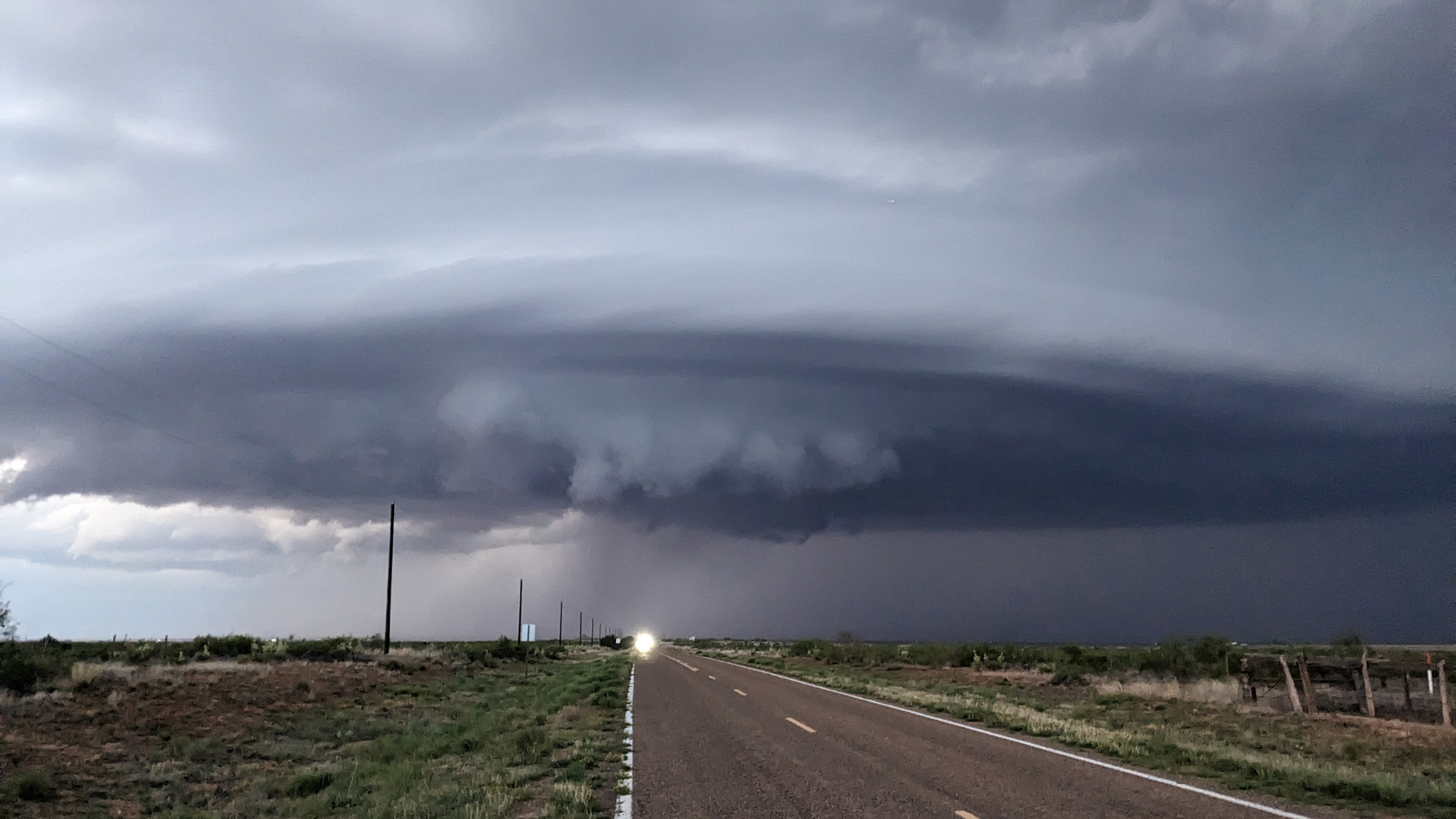
On May 24, 2023, storm chaser Cyrena Arnold encountered one of the angriest storms she had ever experienced in Tucumcari, New Mexico. The teal colors come from the large hail falling inside the storm, and inflow winds were 50 to 70+ mph. It produced multiple tornadoes and wreaked havoc in the area. Image: Cyrena Arnold
What is storm chasing?
While the answer may seem obvious, the true definition of storm chasing has evolved over the years, as more hobbyists are going out in search of tornadoes—hobbyists not all that different from Glen Powell’s Tyler Owens in Twisters.
For some, the whole point may be “trying to get as close to touching it as humanly possible without dying,” says Arnold. Others want to see the power of nature up close and snap photographs of its raw beauty.
From a scientific standpoint, storm chasers can collect important data on storms, including wind speed, direction, and precipitation. They can also help weather forecasters get on-the-ground data that even the most advanced radar might not see.
A meteorologist looking at a radar can understand that there might be a tornado in one spot or a severe thunderstorm with rotating clouds ready to spawn a tornado somewhere else. But radar coverage still isn’t perfect, nor does it tell the whole story of what’s happening on the ground. Enter storm chasers. They’re the folks, on the ground, relaying exactly what they see.
“Storm spotters [another term for chasers] are actually a very critical part of that warning piece. We can be the eyes and ears on the ground for the National Weather Service, whether you’re a meteorologist or not,” says Arnold, who has over 20 years of storm chasing experience.
To stay safe while chasing storms, meteorologists like Arnold always need an exit plan. This storm with rotating wall clouds rolled through Clovis, New Mexico, in May of 2023. Image: Cyrena Arnold
The real art of storm chasing
There is a lot of camaraderie among storm chasers and it is not as competitive as the movies make it seem. This is important, as safe storm chasing always involves sharing data and teamwork. Rival teams stealing each other’s research as depicted in Twister is more for the movie drama.
It is impossible to drive, navigate, and watch the forecast all at once. Arnold is her team’s driver, partly because she is a self-proclaimed gear head, but she also gets car sick and would have trouble looking at forecast models and GPS while the car is moving.
Once a team figures out when they are going to go out based on what forecasting models are saying, they will continue to track changes and listen to local forecasts constantly. The goal is to pinpoint exactly where the team ought to be, in order to spot a tornado. And that is no easy task, akin to finding a needle in a haystack.
“Maybe I know things are going to blow up in east Kansas, but east Kansas is a really big place,” Arnold explains. “So I need to know where I should be, down to what town I want to be [in].”
This evening storm in Elida, New Mexico, on May 26, 2023, was stationary for almost three hours and included over two inch diameter hail and pouring rain, resulting in a lot of damage and flooding in the area. Image: Cyrena Arnold
Chasers will also look at signals coming from the atmosphere, like cloud formations, that can indicate where a storm might emerge. Tornadoes typically form in cumulonimbus clouds. These massive, dense, towering clouds are associated with severe weather, including hail, heavy rain, thunder, lightning, and tornadoes
“I am looking to be downstream of storms, just slightly where they initiate,” Arnold explains. This way, she can watch how the entire storm progresses, not just the tornado.
“Where [tornadoes] initiate you get these towering cumulus clouds that start to grow and form,” she says.
Chasers must also do the “boring” yet necessary steps in advance of the storm—charge cameras and batteries, gas up the car, eat a good meal, and consider what’s on your feet when looking at the sky.
“I know this sounds like a really weird one, but you don’t go storm chasing in flip flops,” Arnold says.
Arnold is her team’s driver and stays in communication with other teams on the road via radio. Image: Cyrena Arnold
The perfect storm
One of the biggest misconceptions about storm chasing is that you will see a tornado every time you go out on a chase.
“Your ratio is about one to 10. So, for every 10 storms you chase, you’ll probably find one,” Arnold explains. Since all tornadoes originate from severe thunderstorms, sometimes chasers will end up collecting data on these powerful thunderstorms. While not quite as dramatic, this can still help meteorologists improve their forecasts, as thunderstorms can lead to dangerous flooding and winds even if they don’t spawn a single tornado. Still, following a tornado is still the prize of the day.
That said, if all of the variables align and you are in the right place at the right time, it’s time to watch. For some, that means analyzing the meteorological data coming in. Others are snapping photos and keeping the team safe from any flying debris.
As the storm progresses, chasers will also look to see where it’s moving or if other storms are popping up nearby. Arnold says they’ll continue to move a few miles here and there in “very small changes, like a chessboard.”
With all of that debris and rain, it’s also crucial for navigators to get a sense of how road networks are affected.
“In places like the middle of nowhere Kansas, roads turn to the slickest, gooiest, nastiest mud you’ve ever seen and you will get stuck,” says Arnold. “So, understanding how the road conditions are changed is important for our exit strategies.”
A storm slowly travels south toward Clovis, New Mexico. Inflow winds were incredibly strong and Arnold saw the storm produce a brief tornado shortly after this photo was taken. Image: Cyrena Arnold.
If a storm shifts direction, understanding the road conditions is critical for that exit plan. While storm paths can be unpredictable, the majority move from west to east due to the jetstream. This powerful “air river” moves storm systems from west to east across land and oceans due to how the Earth rotates around the sun.
Most of the time, simply driving south is an easy escape route if a team needs to get out of the way fast. Unlike hurricanes, which span vast areas, tornado paths are more narrow and it is easier to get out of its way.
Storm chasing is not nearly as deadly as the movies make it out to be. While the exact number is debated, only a handful of people have died while storm chasing. In 2013, storm chaser and meteorologist Tim Samaras, his storm chaser partner Carl Young, and son Paul Samaras were killed near El Reno, Oklahoma. First responders found Tim Samaras inside of his car with his seat belt still on, while Paul Samaras and Young were pulled from the car by a tornado.
No flying cows, but hail the size of DVDs
During one particularly strong storm outbreak in southwest Texas in May 2024, Cyrena and her storm chasing crew experienced a whole new category of hail during an EF3 tornado. The Enhanced Fujita (EF) scale measures a tornado’s wind speed and its related damage. An EF3 tornado, like this one Cyrena and her team were chasing, have winds between 136 and 165 miles per hour.
“We were between Midland and Odessa, and they put the largest hail warning they’ve ever had on a storm ever for DVD sized hail,” Arnold recalls. “It was the first time they had ever used that comparison and not something like ping pong, golf ball, or quarter.”
There was plenty of warning that this massive hail was coming and the team was able to get out of harm’s way. Arnold and other meteorologists tell stories like these on the podcast she runs with a team of meteorologists called The Stormfront Freaks
Still, even in the face of danger, storm chasing is a valuable public safety resource. It also gives weather geeks and hobbyists a front-row seat to the wonders of nature.
“You get out there and you feel so small. You feel so insignificant and seeing what Mother Nature is capable of is just incredible,” says Arnold.
In Ask Us Anything, Popular Science answers your most outlandish, mind-burning questions, from the everyday things you’ve always wondered to the bizarre things you never thought to ask. Have something you’ve always wanted to know? Ask us.
Hong Kong sweltered on Friday, with temperatures exceeding 36 degrees Celsius in the northern New Territories by mid-afternoon.
A heatwave in Hong Kong in late May 2026. Photo: Kyle Lam/HKFP.
Acting Assistant Director of the Hong Kong Observatory (HKO) Choy Chun-wing told RTHK on Friday that minimum temperatures remained at, or above, 28 degrees Celsius over the past six days – matching a record seen in mid-May 2021. The longest continuous record could be broken by the weekend.
The HKO
Hong Kong sweltered on Friday, with temperatures exceeding 36 degrees Celsius in the northern New Territories by mid-afternoon.
A heatwave in Hong Kong in late May 2026. Photo: Kyle Lam/HKFP.
Acting Assistant Director of the Hong Kong Observatory (HKO) Choy Chun-wing told RTHK on Friday that minimum temperatures remained at, or above, 28 degrees Celsius over the past six days – matching a record seen in mid-May 2021. The longest continuous record could be broken by the weekend.
The HKO has suggested some relief from the weeklong heatwave is in store, with rain predicted for the weekend.
“The anticyclone aloft will weaken tomorrow, while upper-air disturbances will bring showers and thunderstorms to Guangdong. An easterly airstream will affect the coast of Guangdong in the next couple of days. High temperature weather will be alleviated,” the weather service said on Friday.
Temperatures as of 2.45pm on May 29, 2026. Photo: HKO.
But it added that high temperatures may soon return. “With the easterly airstream being replaced by a southerly airstream early next week, the weather over the coastal areas will be very hot again midweek next week.”
At a Thursday press briefing, the Senior Citizen Home Safety Association’s CEO Maura Wong said that it had handled over 7,700 heat-related emergency assistance cases requiring hospitalisation last summer.
“The Association urges the elderly to take precautions against the heat during the height of summer, and carers should also take a more proactive role in looking after the elderly by providing timely care and support,” she said.
A heatwave in Hong Kong in late May 2026. Photo: Kyle Lam/HKFP.
At the same event, the HKO’s Choy warned that sea surface temperatures in the central and eastern equatorial Pacific are predicted to continue rising, with an El Niño event set to develop in the summer and autumn.
Stronger El Niño events often increase the likelihood of abnormally high temperatures across different regions. Choy warned of a high chance that this summer would be among Hong Kong’s 10 hottest on record.
A heatwave in Hong Kong in late May 2026. Photo: Kyle Lam/HKFP.
The Labour Department hoisted the amber Heat Stress at Work Warning on Friday, urging employers to conduct risk assessments for staff who work outdoors or in non-air-conditioned environments.
Employers “should take necessary preventive and control measures, including rescheduling work periods, setting up shading covers, providing ventilation and heat dissipation equipment, and reminding employees to replenish water and rest in a timely manner,” the department said in a press release.
Planet warming
The Intergovernmental Panel on Climate Change has warned that the intensity and frequency of heatwaves have continued to increase since the 1950s due to human-caused climate change. The prevalence of greenhouse gases like carbon dioxide – which trap heat in the atmosphere – raises the planet’s surface temperature, with hotter, longer heatwaves putting lives at risk.
Hong Kong has already warmed by 1.7 degrees Celsius since the Industrial Revolution, research NGO Berkeley Earth says. Heat and humidity may reach lethal levels for protracted periods by the end of the century, according to a 2023 study, making it impossible to stay outdoors in some parts of the world.
Northward on our ten-week Great Bear Sea trip last summer, the first “new-to-us” stopover was Philip Inlet, a small notch on the east shore of Fitz Hugh Sound just south of Addenbroke Island. As you can see from the photo above, it was raining steadily when we arrived, making it challenging to spot the narrow […]
Northward on our ten-week Great Bear Sea trip last summer, the first “new-to-us” stopover was Philip Inlet, a small notch on the east shore of Fitz Hugh Sound just south of Addenbroke Island. As you can see from the photo above, it was raining steadily when we arrived, making it challenging to spot the narrow […]
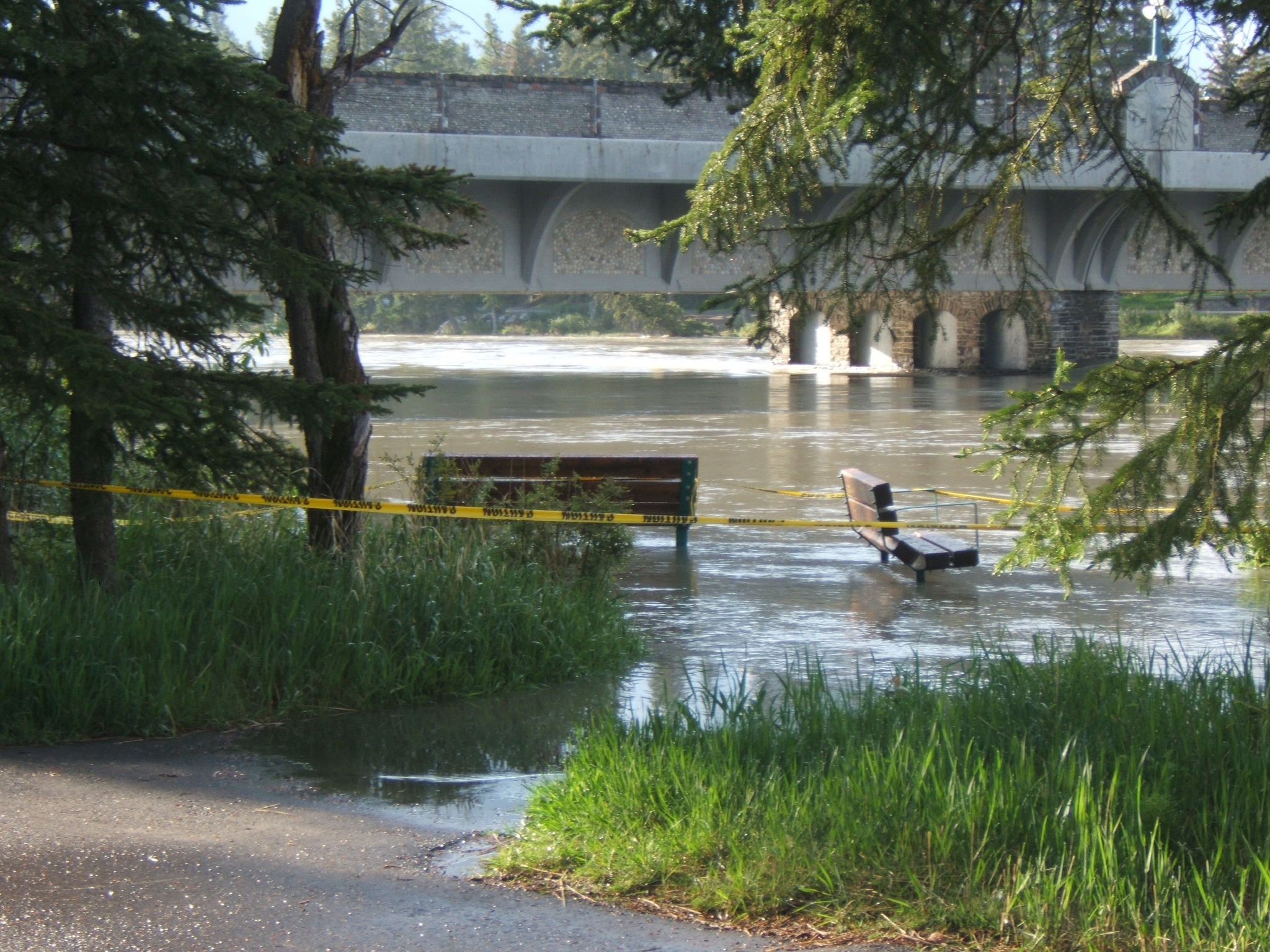
Rising waters, caused by unseasonably warm temperatures, has prompted a high streamflow advisory to be issued for the Bow River in Banff National Park.
Rising waters, caused by unseasonably warm temperatures, has prompted a high streamflow advisory to be issued for the Bow River in Banff National Park.
In its annual forecast of the upcoming Atlantic Hurricane season, NOAA suggests the 2026 season has a 55% chance of being below normal, compared with a 35% chance of being near normal and just a 10% chance of being above normal.
The forecast, announced at a press conference at the NOAA Aircraft Operations Center in Lakeland, Fla., includes 8 to 14 named storms (with winds of at least 39 miles per hour), 3 to 6 of which will be hurricanes (with winds of at least 74 miles per hour). One to thr
In its annual forecast of the upcoming Atlantic Hurricane season, NOAA suggests the 2026 season has a 55% chance of being below normal, compared with a 35% chance of being near normal and just a 10% chance of being above normal.
The forecast, announced at a press conference at the NOAA Aircraft Operations Center in Lakeland, Fla., includes 8 to 14 named storms (with winds of at least 39 miles per hour), 3 to 6 of which will be hurricanes (with winds of at least 74 miles per hour). One to three of those are forecast to be major hurricanes (category 3 to 5 storms, with winds of at least 111 miles per hour).
NOAA forecasts that a below-average hurricane season is most likely in 2026, largely because of El Niño conditions. Credit: NOAA
A below-average number of hurricanes does not reduce the need for people to be prepared, NOAA representatives emphasized.
“Even though we’re expecting a below-average season in the Atlantic, it’s very important to understand that it only takes one.”
“Even though we’re expecting a below-average season in the Atlantic, it’s very important to understand that it only takes one,” said Under Secretary of Commerce for Oceans and Atmosphere and NOAA Administrator Neil Jacobs. “We have had category 5s make landfall in the past during below-average seasons.”
In contrast, NOAA is forecasting an above-average season in the Pacific, with a 70% likelihood of above-normal activity.
Matthew Rosencrans, lead hurricane forecaster with NOAA’s National Weather Service, noted that the Atlantic forecast does not yet contain information about potential hurricane landfalls, just the likelihood of their formation. National Weather Service Director Ken Graham said the potential for rapid intensification—when wind speed increases by at least 35 miles per hour over the course of 24 hours—makes early preparedness particularly important.
“Every category 5 that’s made landfall in this country was a tropical storm or less 3 days out,” he said. “So they rapidly intensified that quick. You think you might have a week on your timeline. The reality is you may only have days.”
“There will never be a ‘Hurricane Justa,’” he added. “There’s no such thing as just a category 1, just a tropical storm, just a category 2.…Even the smallest storm, if it’s slow enough and big enough, it’s going to be catastrophic flooding and storm surge.”
The Atlantic hurricane season runs from 1 June to 30 November. The NOAA forecast is in line with an Atlantic hurricane forecast issued 9 April by Colorado State University (CSU), which predicted 13 named storms and 6 hurricanes, including 2 major hurricanes. Similarly, a forecast released 22 April by North Carolina State University predicted 12 to 15 named storms, 6 to 9 hurricanes, and 2 to 3 major hurricanes.
All three forecasts are slightly below the average Atlantic hurricane numbers for 1991–2020: 14.4 named storms, 7.2 hurricanes, and 3.2 major hurricanes.
The World Meteorological Organization has released its list of 2026 Atlantic tropical cyclone names. Credit: NOAA
El Niño
The forecast for below-average activity levels largely stems from El Niño, a climate pattern that increases vertical wind shear over the tropical Atlantic. Vertical wind shear is how much the speed and direction of wind change with altitude. When wind shear is too high, it can tear a hurricane apart before it forms.
“Wind shear is good for us, bad for the hurricanes,” said Phil Klotzbach, a hurricane forecaster at Colorado State University and lead author of the CSU report.
This year, researchers suggest El Niño could become the strongest in modern history, which could have ripple effects on global temperatures. At the NOAA press conference, Jacobs said that there is a 98% chance of El Niño conditions occurring later this season and an 80% chance that it will be moderate to strong. The forecasted strength of El Niño has only grown since CSU issued its forecast, Klotzbach said.
However, in addition to high wind shear, El Niño is also characterized by unusually warm waters in the Pacific. Klotzbach compared the warm waters of El Niño to loaded dice.
“If the waters are a little bit warmer, that will load the dice for the storm to get stronger.”
“To get to a hurricane, you need to have warm water,” he said. “You need to have a lot of other stuff as well, but if the waters are a little bit warmer, that will load the dice for the storm to get stronger.”
El Niño isn’t the only reason our oceans are warming.
At a press briefing hosted by Covering Climate Now prior to the NOAA press conference, Shel Winkley, a meteorologist at Climate Central, noted that about 90% of the excess heat caused by greenhouse gas emissions has gone into Earth’s oceans, as the planet tries to keep our atmosphere in balance.
“We’re not saying that climate change necessarily creates hurricanes,” Winkley said. “But it is supercharging them: More intense winds, heavier rain, bigger flooding. That’s the connection that we can confidently draw.”
Citation: Gardner, E. (2026), NOAA forecasts a below-average hurricane season, Eos, 107, https://doi.org/10.1029/2026EO260171. Published on 21 May 2026.
With matches in 16 cities across the US, Mexico and Canada, players and fans face an array of weather-related challengesWith the 2026 World Cup now under way, all 48 teams face a common opposition: summer weather across North America. Matches will be played in 16 cities, from southern Mexico to Canada, with a range of weather risks possible at each venue.Thunderstorms disrupted play before the tournament had even begun. England’s warm-up against Costa Rica in Orlando was delayed by about an hour
With matches in 16 cities across the US, Mexico and Canada, players and fans face an array of weather-related challenges
With the 2026 World Cup now under way, all 48 teams face a common opposition: summer weather across North America. Matches will be played in 16 cities, from southern Mexico to Canada, with a range of weather risks possible at each venue.
Thunderstorms disrupted play before the tournament had even begun. England’s warm-up against Costa Rica in Orlando was delayed by about an hour after storms brought lightning and heavy rain that waterlogged the pitch. Safety regulations at US venues mean play is suspended when lightning is recorded within roughly 8 miles of a stadium, not resuming until 30 minutes after the last strike.
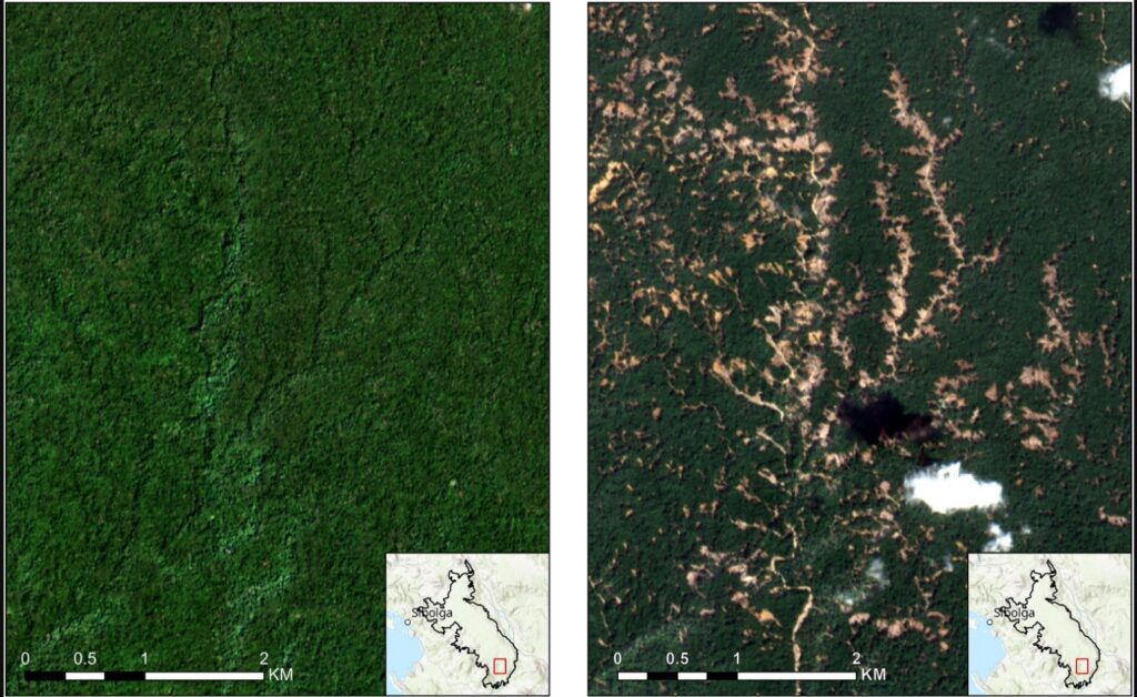
In November 2025, Cyclone Senyar generated extreme rainfall in parts of Sumatra, Indonesia, triggering thousands of landslides. Our new paper in the journal Current Biology demonstrates that these landslides might have a devastating impact on a critically endangered population of Tapanuli orangutan.
In November 2025, Cyclone Senyar brought extreme rainfall to large parts of Sumatra in Indonesia. I have written about this on previous occasions – the rainfall triggered vast numbers of lan
In November 2025, Cyclone Senyar generated extreme rainfall in parts of Sumatra, Indonesia, triggering thousands of landslides. Our new paper in the journal Current Biology demonstrates that these landslides might have a devastating impact on a critically endangered population of Tapanuli orangutan.
In my line of work, we often focus on the landslide impacts on the landscape, on human lives and on infrastructure. We rarely consider the impacts on th eanimal population. This is certainly a weakness that the Cyclone Senyar event brings to focus.
Part of the area devastated by the landslides is that slopes around the Batang Toru rover, an area of forest that is home to a rare species of orangutang. These great apes, Pongo tapanuliensis, live in a habitat known as the West Block of Tapanuli. There are only 800 individuals left in the wild, a situation that is highly precarious. The loss of even a small number of adults could tip the species towards extinction.
I was a part of a consortium of scientists that considered the landslide impacts of Cyclone Senyar on the habitat of these orangutangs. The results have just been published in the journal Current Biology (Meijaard et al. 2026) – the paper is open access and published under a creative commons license.
This image, from the paper, shows the landslide impacts of Cyclone Senyar:-
Before and after satellite imagery of the impacts of Cyclone Senyar. From: Meijaard et al. (2026).
In the study area of 71,161 hectares, the mapping indicates that there were 50, 185 individual landslides, covering a surface area of 8,303 hectares. This is about 11% of the forested area. We then estimate the likely loss of the orangutang population, which is likely to be in the range of 18-120 individuals, with a central estimate of 58 individuals. This is likely to have been a devastating loss for this highly endangered population.
This level of habitat loss might also be placing a severe pressure on the remaining population, so further fatalities are very possible through, for example, reduced food availability.
The intensity of the rainfall was almost certainly supercharged by climate change. The impacts of Cyclone Senyar are being replicated widely – and of course we are now in the northern hemisphere tropical cyclone season again.
Our paper makes some policy recommendations for this population of orangutans. First, the government of Indonesia needs to permanently protect this area of forest against mining , palm oil and hydropower developments. Ideally, the protected area should be expanded. Second, Indonesia needs support for biodiversity-recovery, hazard forecasting and ecological restoration planning.
Hong Kong authorities have deployed powerful machines known as “water-pumping dragons” to clear flooding after the city’s northern territories were hit by heavy rainfall overnight.
The Drainage Services Department deploys a powerful machine known as the “water-pumping dragon” to clear flooding on May 20, 2026. Photo: Drainage Services Department, via Facebook.
The Drainage Services Department said on social media early on Thursday that its teams had cleared seven instances of flooding in
Hong Kong authorities have deployed powerful machines known as “water-pumping dragons” to clear flooding after the city’s northern territories were hit by heavy rainfall overnight.
The Drainage Services Department deploys a powerful machine known as the “water-pumping dragon” to clear flooding on May 20, 2026. Photo: Drainage Services Department, via Facebook.
The Drainage Services Department said on social media early on Thursday that its teams had cleared seven instances of flooding in the northern part of the New Territories using the devices, which authorities procured from mainland China last year due to more frequent extreme downpours.
The Observatory issued the red rainstorm warning at 2.40am due to heavy rain in the city’s border areas near Shenzhen, especially in Sheung Shui, Ta Kwu Ling, and Sha Tau Kok. A special landslide warning was also issued.
The rainstorm signal was downgraded to amber at 5.15am and eventually cancelled at 9.30am. The weather services warned of the risk of river flooding.
The heavy rain was associated with “upper-air disturbances… persistently affecting the vicinity of the Pearl River Estuary,” the Observatory said on Thursday.
“Locally, more than 50 millimetres of rainfall were recorded over widespread areas this morning, and rainfall even exceeded 100 millimetres over many parts of the New Territories,” it added.
The flooding was concentrated in Sheung Shui and Fanling, while the Shek Kong Airfield Road was also affected, according to the Drainage Services Department.
An emergency control centre was activated at 9.45pm on Wednesday, and 90 response teams were deployed to inspect and clear flooding, the department said.
Images and videos of severe flooding went viral on social media platforms. Clips posted on Threads show floodwater entering a bus in Ping Che and a taxi trapped on the road.
Screenshot of a video shows floodwater entering a bus in Ping Che in Hong Kong in the early hours of May 20, 2026. Photo: t_tsuntsun, via Threads.
Screenshot of a video shows a taxi trapped in floodwater in Ping Che, Hong Kong, in the early hours of May 20, 2026. Photo: t_tsuntsun, via Threads.
Last year, after the city hoisted the black rainstorm warning four times within a week, a former Observatory official warned that extreme weather would become more frequent due to the climate crisis.
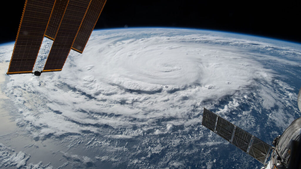
The National Weather Service said it received more than a dozen reports of tornadoes Wednesday across northern Missouri, Iowa, Kansas and Illinois. Trees and utility wires were reported down across the region.
The National Weather Service said it received more than a dozen reports of tornadoes Wednesday across northern Missouri, Iowa, Kansas and Illinois. Trees and utility wires were reported down across the region.


:max_bytes(150000):strip_icc():format(jpeg)/floyd-mayweather-kids-1-c1e51f92cde24865a7d76f54ba1be1be.jpg)