A wonderful new paper on the huge Tracy Arm landslide and tsunami will have profound but challenging implications for the management of risk in an age of increased tourism and rapid climate change.
The journal Science has published an excellent new paper (Shugar et al. 2026) that examines the extraordinary 10 August 2025 landslide and tsunami at Tracy Arm fjord in Alaska. The paper is open access, so you can read it for yourself (it is very accessible), and there has been a plethora
A wonderful new paper on the huge Tracy Arm landslide and tsunami will have profound but challenging implications for the management of risk in an age of increased tourism and rapid climate change.
The journal Science has published an excellent new paper (Shugar et al. 2026) that examines the extraordinary 10 August 2025 landslide and tsunami at Tracy Arm fjord in Alaska. The paper is open access, so you can read it for yourself (it is very accessible), and there has been a plethora of media coverage (quite rightly).
That large landslides occur in fjords is not a surprise, and that they can generate enormous displacement waves is also not news. We know that landslide occurrence in these environments in general is increasing, and specifically so in Alaska. However, this paper is the most comprehensive and systematic analysis of such an event, and it has shown the remarkable threat that these events can generate. The tsunami created by this landslide had a 481 metre run-up; it is remarkable that there were no fatalities. If a large cruise ship had been in the area, with passengers being ferried ashore on small boats and exploring the shoreline, the consequences would have been catastrophic. It is unsurprising then that cruise companies are now amending their itineraries.
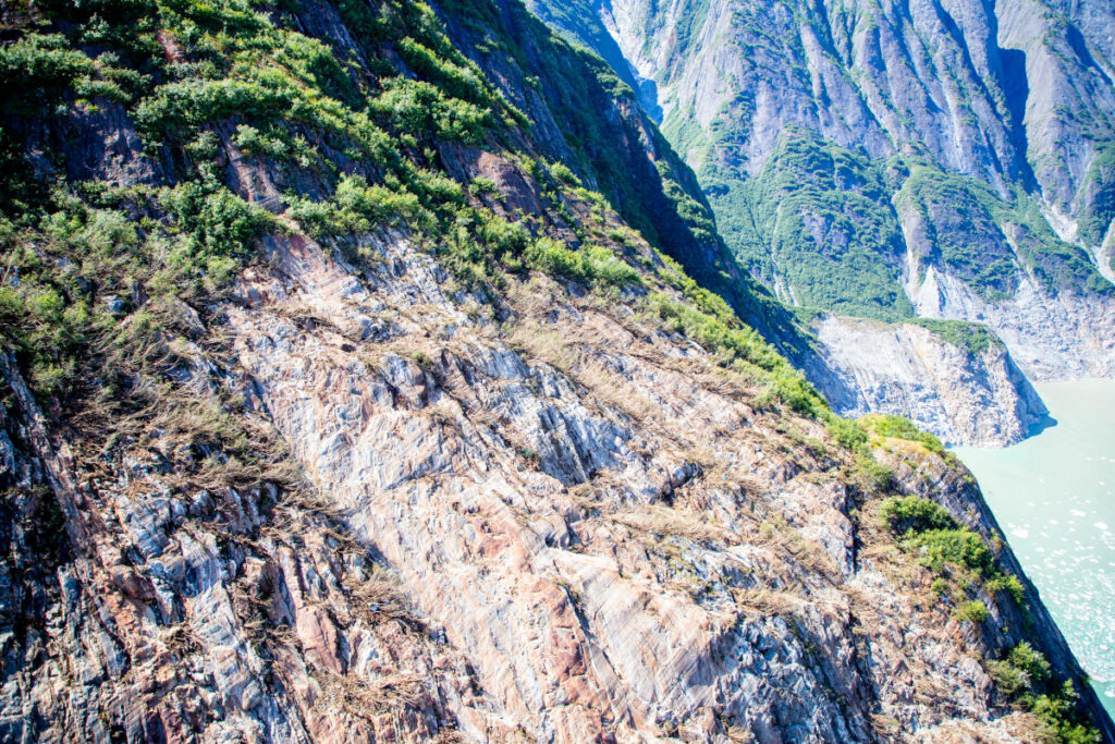
The USGS released the image below of the aftermath of the landslide and tsunami – scale is hard to understand in such images, but the crown of the landslide is over 1,000 metres above the level of the fjord, and the landslide had a subaerial volume of over 63 million cubic metres.
This aerial photo shows the north side of Alaska’s Tracy Arm Fjord in the aftermath of the 2025 landslide and tsunami. The lighter-colored rock is the exposed surface, where the mountainside collapsed and fell into the water. The foot of South Sawyer Glacier is visible at lower right; in decades past, the ice extended much farther and was thick enough to hold the rock slopes in place. Credit: Cyrus Read/U.S. Geological Survey
Shugar et al. (2026) has a brief section that examines the implications of this event, and of the understanding that it provides of the hazards posed by very large landslides in fjord settings. These are locations with extensive human activity – local communities, trade, fishing and tourism. There is some evidence that these landsldies are more likely to occur in the spring and summer months, when human occupation is higher. Our resilience to a tsunami wave that starts off being hundreds of metres high is low.
A case in point lies in Milford Sound in New Zealand, where (for example) an earthquake on the Alpine Fault has the potential to trigger a large landslide that could result in a major tsunami. Milford Sound is an extremely popular tourism location. Should such an event occur, and mass fatalities result, there is no doubt that the public inquiry would find that the societal risk was known and that it was probably unacceptable. However, to ban tourism, including cruise ships, in this area would carry heavy risks in its own right – it would profoundly impact the vital tourist economy of the area, on which many livelihoods depend. This is a substantial risk in its own right, and of course politics plays a major part too. Balancing these risks is a major challenge for any society.
Some hope is offered by the fact that this landslide showed substantial precursory seismic activity, which might represent a route to providing a warning for at least some of these rock slope failures. But research in this area is immature at the moment, and of course there will be no warning for a landslide triggered by a major earthquake.
So, the landslide at Tracy Arm fjord presents us with a host of major challenges, but it also represents a big step forward in our understanding of these events. Well done to Dan and his colleagues for another brilliant paper. I shall watch the debate with great interest.
SantaChristmas treesBlank to do your own thing
A fun Christmas activity – print your own Christmas cracker. There are three versions, Santa on a bike, Christmas trees, and a blank one for you to do your own thing.
What you will need
A functioning printer, and card or paper you can print on. It will work fine with paper but will be less rigid than card. A3 might be ideal, but most of us don’t have an A3 printer, so A4 will work too, it will just be smaller. Also scissors, and if y
A fun Christmas activity – print your own Christmas cracker. There are three versions, Santa on a bike, Christmas trees, and a blank one for you to do your own thing.
What you will need
A functioning printer, and card or paper you can print on. It will work fine with paper but will be less rigid than card. A3 might be ideal, but most of us don’t have an A3 printer, so A4 will work too, it will just be smaller. Also scissors, and if you want to colour them in, art materials.
Instructions
1. Print with as small a margin as your printer will manage. The files are at the end of this post. I’d recommend the pdfs if they will work for you, but I’ve supplied image files as an alternative.
2. Fold along the six dotted lines, as it’s easier to do the folding before you start cutting. Hopefully it’s fairly obvious which folds go which way – you should end up with two ‘ridges’. See my photo for vague and approximate guidance.
3. With just the two dotted lines folded (the ones in the middle of the three at each end – if that makes sense) cut out the solid line sections with scissors. You should be able to cut through two layers of paper so you’re cutting out a diamond shape each time. Really tricky to explain.
4. You can colour it at any point, but perhaps best to colour after cutting in case you spend ages colouring then do the cutting wrong and it ends up in pieces…
5. Gather whatever is going into the cracker. Could be a hat, a joke you write yourself, chocolate, anything*! [*That will fit in, you have available, etc etc]
6. Then roll the cracker as best you can into the cracker shape and stick with tape. Glue might work I suppose, but I wouldn’t advise it.
7. It won’t go ‘bang’, so you’ll have to shout that.
Allsopp's ales are back on tap at The Blue Stoops, Jamie Allsopp's unique ‘proper pub’ in West London, where fresh real ales and stellar British cuisine share the bill.
Allsopp's ales are back on tap at The Blue Stoops, Jamie Allsopp's unique ‘proper pub’ in West London, where fresh real ales and stellar British cuisine share the bill.
This award-winning craft gin originates from Umbria, Italy and uses fresh Italian juniper, Mediterranean citrus, and peperoncino to achieve a unique flavor profile.
This award-winning craft gin originates from Umbria, Italy and uses fresh Italian juniper, Mediterranean citrus, and peperoncino to achieve a unique flavor profile.
Initial analyses suggest that the earthquake this morning has the potential to have triggered significant numbers of landslides and areas of liquefaction.
At the time of writing, the impacts of the M=7.8 earthquake that occurred offshore the south coast of Mindanao in the Philippines remain unclear. Initial reports in the local press suggest 15 fatalities so far, but as always it could be the case that there is no information from those areas most seriously impacted.
The USGS Pager s
Initial analyses suggest that the earthquake this morning has the potential to have triggered significant numbers of landslides and areas of liquefaction.
At the time of writing, the impacts of the M=7.8 earthquake that occurred offshore the south coast of Mindanao in the Philippines remain unclear. Initial reports in the local press suggest 15 fatalities so far, but as always it could be the case that there is no information from those areas most seriously impacted.
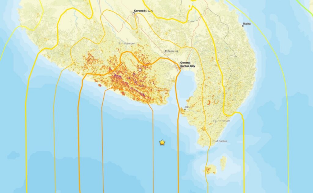
The USGS Pager site is the best source of information about potential landslide impacts, bearing in mind there is a high level of uncertainty. This estimates that the area exposed to landslides is at the high end of the “significant” scale and that the population exposed to landslides lies in the 1,000 to 10,000 people range. This is the Pager landslide hazard map:-
Initial Pager map of landslide hazard from the 8 June 2026 earthquake offshore Mindanao in the Philippines. Source: USGS.
The area with the highest level of landslide hazard is remote and rural, so we may not get good information from this area for a while.
The potential for liquefaction may be even more serious, with a broad swathe having a high level of hazard:-
Initial Pager map of liquefaction hazard from the 8 June 2026 earthquake offshore Mindanao in the Philippines. Source: USGS.
One final point to note is that the Philippines is just entering the typhoon season. Fortunately, Mindanao is sufficiently far south to be away from the main typhoon zone. However, these storms are so large that they can bring very heavy rainfall – see for example Typhoon Bopha in 2012. A similar event this year could have very significant consequences.
Ⓜ Mathilde De Cyriac posted a photo:
This Saturday, June 6 at 2:00 PM SLT, a techno set from DJ Plastics and hypnotic techno from DJ Kastor, an experience you could only call divine.
Leave your binary body behind and dissolve into the mesh that wraps around us all at VICE Nights Club. We'll be waiting for you on the dance floor!@ maps.secondlife.com/secondlife/Quesada/47/44/3873
[UX] Unorthodox Moskii Curls
maps.secondlife.com/secondlife/Orchid/156/92/754
Pretty Damage PixelPop Mobile
This Saturday, June 6 at 2:00 PM SLT, a techno set from DJ Plastics and hypnotic techno from DJ Kastor, an experience you could only call divine.
Leave your binary body behind and dissolve into the mesh that wraps around us all at VICE Nights Club. We'll be waiting for you on the dance floor!@ maps.secondlife.com/secondlife/Quesada/47/44/3873


