Hongkongers sweated through the hottest day of the year on Friday, with the Observatory (HKO) recording a maximum temperature of 34.6 degrees Celsius at its headquarters.
Yung Shue Wan, Lamma Island on Friday, June 5, 2026. Photo: HKFP.
The mercury neared 37 degrees Celsius in the northern part of the territory.
Maximum temperatures in Hong Kong on June 5, 2026. Photo: HKO.
Meanwhile, the Observatory noted 1,263 instances of cloud-to-ground lightning on Friday, and 4,859 cases of cl
Hongkongers sweated through the hottest day of the year on Friday, with the Observatory (HKO) recording a maximum temperature of 34.6 degrees Celsius at its headquarters.
Yung Shue Wan, Lamma Island on Friday, June 5, 2026. Photo: HKFP.
The mercury neared 37 degrees Celsius in the northern part of the territory.
Maximum temperatures in Hong Kong on June 5, 2026. Photo: HKO.
Meanwhile, the Observatory noted 1,263 instances of cloud-to-ground lightning on Friday, and 4,859 cases of cloud-to-cloud lightning.
The city is now set to see nine days of rain, the weather service predicts.
Cloud-to-ground lightning count distribution on June 6, 2026. Photo: HKO.
“A broad trough of low pressure will linger over the vicinity of the coast of southern China to the northern part of the South China Sea during the weekend to midweek next week,” the Observatory said.
The amber rainstorm warning was raised at 10am on Saturday as violent gusts swept into the territory, raising the risk of flooding.
Friday marked the hottest “Grain in Ear” solar term ever documented. The ninth traditional solar term, known in Chinese as Mangzhong, signifies a period when awny crops like wheat are ready to harvest.
A heatwave in Hong Kong in late May 2026. Photo: Kyle Lam/HKFP.
The Intergovernmental Panel on Climate Change has warned that the intensity and frequency of heatwaves have continued to increase since the 1950s due to human-caused climate change. The prevalence of greenhouse gases like carbon dioxide – which trap heat in the atmosphere – raises the planet’s surface temperature, with hotter, longer heatwaves putting lives at risk.
Hong Kong has already warmed by 1.7 degrees Celsius since the Industrial Revolution, research NGO Berkeley Earth says. Heat and humidity may reach lethal levels for protracted periods by the end of the century, according to a 2023 study, making it impossible to stay outdoors in some parts of the world.
Global News' chief meteorologist Anthony Farnell said the humid weather looks set to break just before the 3 p.m. kickoff, with 'fantastic' weather over the weekend.
Global News' chief meteorologist Anthony Farnell said the humid weather looks set to break just before the 3 p.m. kickoff, with 'fantastic' weather over the weekend.
KUALA LUMPUR, June 1 — The Malaysian Meteorological Department (MetMalaysia) has issued a warning of thunderstorms, heavy rain and strong winds expected to affect several areas in six states until 9 pm today.In a statement, MetMalaysia said the adverse weather is forecast to occur on the east coast, involving the districts of Besut, Setiu and Dungun in Terengganu, as well as Bera and Rompin in Pahang.Similar conditions are also expected in Jempol, Negeri Sembilan
KUALA LUMPUR, June 1 — The Malaysian Meteorological Department (MetMalaysia) has issued a warning of thunderstorms, heavy rain and strong winds expected to affect several areas in six states until 9 pm today.
In a statement, MetMalaysia said the adverse weather is forecast to occur on the east coast, involving the districts of Besut, Setiu and Dungun in Terengganu, as well as Bera and Rompin in Pahang.
Similar conditions are also expected in Jempol, Negeri Sembilan, and in Johor, involving Segamat and Mersing.
Meanwhile, in Sabah, the warning covers the Interior division (Nabawan) and Sandakan division (Telupid, Beluran and Sandakan).
In Sarawak, the affected areas are Kuching, Serian, Samarahan, Sri Aman, Betong (Betong), Sibu (Kanowit), Kapit (Song and Bukit Mabong), Miri (Beluru and Telang Usan), and Limbang. — Bernama
Editors’ Highlights are summaries of recent papers by AGU’s journal editors.
Source: Journal of Geophysical Research: Atmospheres
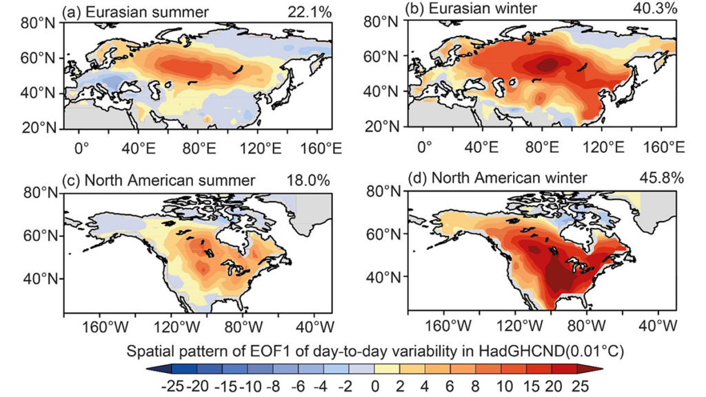
Abrupt temperature swings between consecutive days, referred to as day-to-day temperature variability, have far-reaching impacts on human health, ecosystems, and economic activity. However, how these fluctuations vary from year to year, and what drives them, has remained unclear.
Using observations, reanalysis, and CMIP6 simulations from 1961 to 2014, Liu an
Source: Journal of Geophysical Research: Atmospheres
Abrupt temperature swings between consecutive days, referred to as day-to-day temperature variability, have far-reaching impacts on human health, ecosystems, and economic activity. However, how these fluctuations vary from year to year, and what drives them, has remained unclear.
Using observations, reanalysis, and CMIP6 simulations from 1961 to 2014, Liu and Fu [2026] identify a coherent large-scale pattern of variability across Eurasia and North America. This variability is primarily driven by the north–south movement of warm and cold air masses.
The dominant drivers also vary by season: large-scale meteorological patterns prevail in winter, whereas local land–atmosphere feedbacks become more influential in summer. Together, these processes reshape temperature gradients and modulate storm activity and broader weather systems.
Overall, the findings provide new insights into the mechanisms of temperature variability and offer a scientific basis for improving seasonal climate risk prediction and adaptation strategies.
Citation: Liu, Q., & Fu, C. (2026). Interannual variations in the day-to-day temperature variability in the northern hemisphere and possible causalities. Journal of Geophysical Research: Atmospheres, 131, e2025JD045754. https://doi.org/10.1029/2025JD045754
SiriusXM will begin distributing Fox Weather across its satellite-radio service starting June 3, a move aimed at making more weather news available as hurricane season starts along the Atlantic coast. The channel will be offered to listeners across North America via the SiriusXM app (ch. 799) and in vehicles equipped with SiriusXM with 360L. Access […]
SiriusXM will begin distributing Fox Weather across its satellite-radio service starting June 3, a move aimed at making more weather news available as hurricane season starts along the Atlantic coast. The channel will be offered to listeners across North America via the SiriusXM app (ch. 799) and in vehicles equipped with SiriusXM with 360L. Access […]
Research & Developments is a blog for brief updates that provide context for the flurry of news regarding law and policy changes that impact science and scientists today.
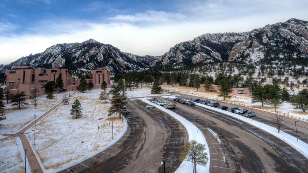
A Colorado judge has granted a preliminary injunction to the University Corporation for Atmospheric Research (UCAR). The move temporarily blocks the federal government from moving forward with one part of its effort to dismantle UCAR’s National Center for Atmospheric Research (NCAR) by transferring stewardship of a
Research & Developments is a blog for brief updates that provide context for the flurry of news regarding law and policy changes that impact science and scientists today.
A Colorado judge has granted a preliminary injunction to the University Corporation for Atmospheric Research (UCAR). The move temporarily blocks the federal government from moving forward with one part of its effort to dismantle UCAR’s National Center for Atmospheric Research (NCAR) by transferring stewardship of a state-of-the-art supercomputing facility.
Together, UCAR—a nonprofit consortium of universities and colleges—and the National Science Foundation (NSF) operate and maintain the NCAR-Wyoming Supercomputing Center (NWSC) in Cheyenne, Wyo. The facility provides scientists with enormous computational power necessary to run sophisticated analyses of weather, climate, and other Earth systems.
In February, as another step in a chain of actions taken to dismantle NCAR, the NSF informed UCAR and NCAR that it would transfer management and operations of NWSC to a third-party operator.
In turn, UCAR filed a lawsuitalleging that the action violated federal law under the Administrative Procedure Act (APA). To halt NSF’s action under the act, the agency’s attempt to remove UCAR’s stewardship of the facility must be shown to be “arbitrary, capricious, an abuse of discretion, or otherwise not in accordance with law.”
Judge Richard Brooke Jackson of the U.S. District Court for the District of Colorado wrote in a 1 June court order that the action was both arbitrary and capricious “for at least two reasons.” First, NSF didn’t offer an explanation for its decision, and second, it didn’t follow an outlined process to consider public feedback.
The decision means that UCAR will temporarily retain its stewardship of NWSC.
“NSF’s failure to provide any explanation for its decision—let alone a reasonable one—thwarts meaningful judicial review and renders the challenged action arbitrary and capricious,” Jackson wrote.
He went on to note that efforts to transfer stewardship of UCAR assets, including the supercomputing center, to other institutions, pose the risk of “irreparable harm” to UCAR. One of the chief harms would be brain drain, the judge noted multiple times, writing that “UCAR cannot easily replace employees with the level of education, specialized training, and institutional knowledge necessary to operate and maintain the NWSC’s ‘highly integrated, high-performance supercomputing system.'”
In addition to brain drain, Jackson cited financial injuries to UCAR that would be “difficult, if not impossible” to quantify, as well as an overall threat to the consortium’s mission.
“Any degradation in forecasting, modeling, or related scientific capabilities carries real-world consequences, including potential harm to property and human life. Given those stakes, the public interest strongly favors maintaining the status quo unless and until NSF demonstrates that its transfer decision complies with the APA,” he concluded.
In a statement posted to the UCAR website, the consortium’s interim president, Eric Barron, said UCAR was pleased that Judge Jackson recognized how harmful the proposed transfer would be for the the nation’s scientific enterprise.
“UCAR’s top priority is to advance Earth system science in service to society,” he wrote. “Today’s decision ensures that the NWSC will be able to continue its vital work on behalf of the United States and its stakeholders without interruption.”
These updates are made possible through information from the scientific community. Do you have a story about how changes in law or policy are affecting scientists or research? Send us a tip at eos@agu.org.
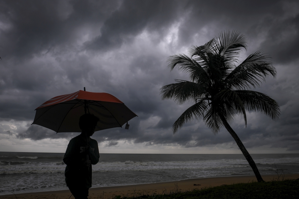
Hong Kong sweltered on Friday, with temperatures exceeding 36 degrees Celsius in the northern New Territories by mid-afternoon.
A heatwave in Hong Kong in late May 2026. Photo: Kyle Lam/HKFP.
Acting Assistant Director of the Hong Kong Observatory (HKO) Choy Chun-wing told RTHK on Friday that minimum temperatures remained at, or above, 28 degrees Celsius over the past six days – matching a record seen in mid-May 2021. The longest continuous record could be broken by the weekend.
The HKO
Hong Kong sweltered on Friday, with temperatures exceeding 36 degrees Celsius in the northern New Territories by mid-afternoon.
A heatwave in Hong Kong in late May 2026. Photo: Kyle Lam/HKFP.
Acting Assistant Director of the Hong Kong Observatory (HKO) Choy Chun-wing told RTHK on Friday that minimum temperatures remained at, or above, 28 degrees Celsius over the past six days – matching a record seen in mid-May 2021. The longest continuous record could be broken by the weekend.
The HKO has suggested some relief from the weeklong heatwave is in store, with rain predicted for the weekend.
“The anticyclone aloft will weaken tomorrow, while upper-air disturbances will bring showers and thunderstorms to Guangdong. An easterly airstream will affect the coast of Guangdong in the next couple of days. High temperature weather will be alleviated,” the weather service said on Friday.
Temperatures as of 2.45pm on May 29, 2026. Photo: HKO.
But it added that high temperatures may soon return. “With the easterly airstream being replaced by a southerly airstream early next week, the weather over the coastal areas will be very hot again midweek next week.”
At a Thursday press briefing, the Senior Citizen Home Safety Association’s CEO Maura Wong said that it had handled over 7,700 heat-related emergency assistance cases requiring hospitalisation last summer.
“The Association urges the elderly to take precautions against the heat during the height of summer, and carers should also take a more proactive role in looking after the elderly by providing timely care and support,” she said.
A heatwave in Hong Kong in late May 2026. Photo: Kyle Lam/HKFP.
At the same event, the HKO’s Choy warned that sea surface temperatures in the central and eastern equatorial Pacific are predicted to continue rising, with an El Niño event set to develop in the summer and autumn.
Stronger El Niño events often increase the likelihood of abnormally high temperatures across different regions. Choy warned of a high chance that this summer would be among Hong Kong’s 10 hottest on record.
A heatwave in Hong Kong in late May 2026. Photo: Kyle Lam/HKFP.
The Labour Department hoisted the amber Heat Stress at Work Warning on Friday, urging employers to conduct risk assessments for staff who work outdoors or in non-air-conditioned environments.
Employers “should take necessary preventive and control measures, including rescheduling work periods, setting up shading covers, providing ventilation and heat dissipation equipment, and reminding employees to replenish water and rest in a timely manner,” the department said in a press release.
Planet warming
The Intergovernmental Panel on Climate Change has warned that the intensity and frequency of heatwaves have continued to increase since the 1950s due to human-caused climate change. The prevalence of greenhouse gases like carbon dioxide – which trap heat in the atmosphere – raises the planet’s surface temperature, with hotter, longer heatwaves putting lives at risk.
Hong Kong has already warmed by 1.7 degrees Celsius since the Industrial Revolution, research NGO Berkeley Earth says. Heat and humidity may reach lethal levels for protracted periods by the end of the century, according to a 2023 study, making it impossible to stay outdoors in some parts of the world.
In November 2025, Cyclone Senyar generated extreme rainfall in parts of Sumatra, Indonesia, triggering thousands of landslides. Our new paper in the journal Current Biology demonstrates that these landslides might have a devastating impact on a critically endangered population of Tapanuli orangutan.
In November 2025, Cyclone Senyar brought extreme rainfall to large parts of Sumatra in Indonesia. I have written about this on previous occasions – the rainfall triggered vast numbers of lan
In November 2025, Cyclone Senyar generated extreme rainfall in parts of Sumatra, Indonesia, triggering thousands of landslides. Our new paper in the journal Current Biology demonstrates that these landslides might have a devastating impact on a critically endangered population of Tapanuli orangutan.
In my line of work, we often focus on the landslide impacts on the landscape, on human lives and on infrastructure. We rarely consider the impacts on th eanimal population. This is certainly a weakness that the Cyclone Senyar event brings to focus.
Part of the area devastated by the landslides is that slopes around the Batang Toru rover, an area of forest that is home to a rare species of orangutang. These great apes, Pongo tapanuliensis, live in a habitat known as the West Block of Tapanuli. There are only 800 individuals left in the wild, a situation that is highly precarious. The loss of even a small number of adults could tip the species towards extinction.
I was a part of a consortium of scientists that considered the landslide impacts of Cyclone Senyar on the habitat of these orangutangs. The results have just been published in the journal Current Biology (Meijaard et al. 2026) – the paper is open access and published under a creative commons license.
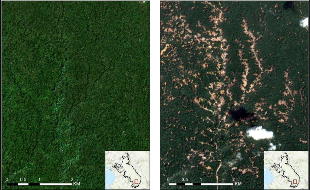
This image, from the paper, shows the landslide impacts of Cyclone Senyar:-
Before and after satellite imagery of the impacts of Cyclone Senyar. From: Meijaard et al. (2026).
In the study area of 71,161 hectares, the mapping indicates that there were 50, 185 individual landslides, covering a surface area of 8,303 hectares. This is about 11% of the forested area. We then estimate the likely loss of the orangutang population, which is likely to be in the range of 18-120 individuals, with a central estimate of 58 individuals. This is likely to have been a devastating loss for this highly endangered population.
This level of habitat loss might also be placing a severe pressure on the remaining population, so further fatalities are very possible through, for example, reduced food availability.
The intensity of the rainfall was almost certainly supercharged by climate change. The impacts of Cyclone Senyar are being replicated widely – and of course we are now in the northern hemisphere tropical cyclone season again.
Our paper makes some policy recommendations for this population of orangutans. First, the government of Indonesia needs to permanently protect this area of forest against mining , palm oil and hydropower developments. Ideally, the protected area should be expanded. Second, Indonesia needs support for biodiversity-recovery, hazard forecasting and ecological restoration planning.
Want your wildfire updates to come from a trusted source? Preference Eos in your searches!
Go to Google
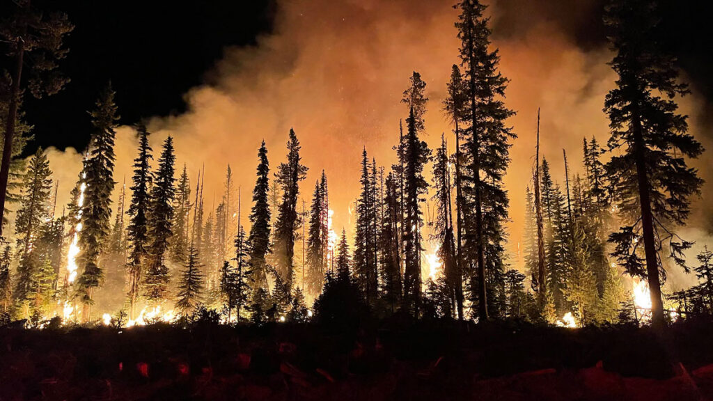
A warm, dry spring has set the stage for above-average significant wildland fire risk across much of the southern and western United States this summer, and no part of the United States will have below-average fire potential through the end of August.
“It’s not necessarily a foregone conclusion that we’re going to have a really busy season, but everything is pointing that way.”
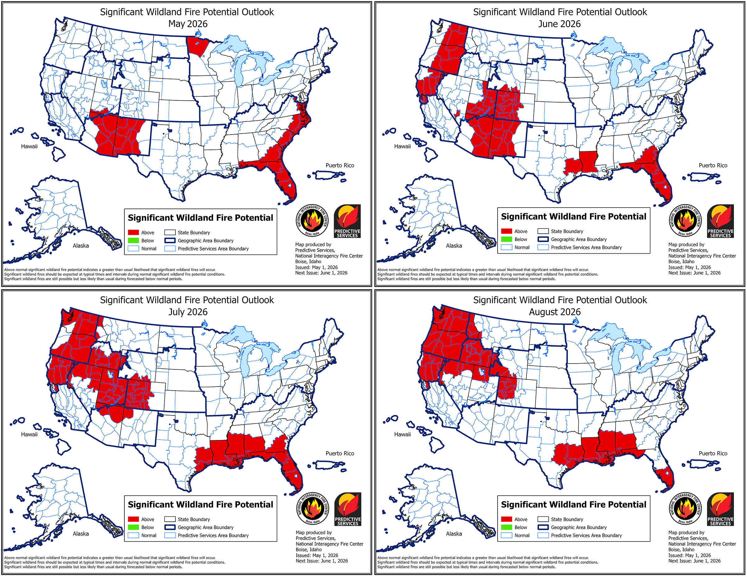
These predictions are part of a 4-month outlook produced monthly by the National Interagency Fire Center (NIFC), a group of wildland fire experts from eight federal agencies that coordinates wildland fire resources across the country.
The most recent outlook, published 1 May, projects the likelihood of significant fires (defined as those that require an NIFC response) from May to August using long-term forecasts from NOAA’s Climate Prediction Center, current precipitation and drought conditions, and an assessment of the fuels available in different regions (like grasses, brush, and timber).
This year, 1,848,210 acres across the country have already burned—nearly twice the annual average over the past 10 years.
“It’s not necessarily a foregone conclusion that we’re going to have a really busy season, but everything is pointing that way,” said Jim Wallmann, a meteorologist for the U.S. Forest Service at the NIFC and one of the outlook’s authors.
Significant wildland fire potential will be elevated across much of the West and Southeast this summer. Click image for larger version. Credit: National Interagency Coordination Center, Public Domain
Drought in the West
In the West, wildfire season typically peaks in late summer. This most recent outlook predicts an above-average significant fire potential for much of the West as the season peaks.
In May, the above-average risk is concentrated in eastern Arizona and western New Mexico, though that risk fades to normal by August as the Southwest’s monsoon season begins. In June, the above-average risk extends to western Colorado and parts of the Pacific Northwest. In July and August, that risk covers much of the Northwest, including Utah, Idaho, Oregon, Washington, and Northern California.
Above-average spring temperatures and a far-below-normal snowpack across the West are contributing to the elevated risk in Washington, Oregon, Idaho, and Northern California, in particular. Many river basins across the West contain less than 20% of their normal amount of snow, and some are already snow-free at all observed locations due to melting caused by warm temperatures in March.
As of May, many river basins in the West have a snow water equivalent—the amount of water held in their current snowpack—that is less than 50% (in red) of the 1991–2020 average level. Credit: USDA Natural Resources Conservation Service, Public Domain
“The snowpack being lower this time of year, and melting out, affects the soil moisture throughout the rest of the summer, which then affects the fuel moistures,” said Craig Clements, a meteorologist at San Jose State University’s Fire Weather Research Laboratory who was not involved in the outlook. Early snowmelt also uncovers fuels, like pine needles and leaf litter, that would typically be under snow, exposing them to the air to dry and catch fire.
Southern California and the Sierra Nevada mountain range, though, remain at an average significant fire risk throughout the summer, as a result of higher-than-average precipitation earlier in the year.
The Southeast and Beyond
Fire risk will also be elevated in the Southeast this summer. Florida, for example, remains at an above-average significant fire potential through the end of August. Southern Georgia, Mississippi, Louisiana, Arkansas, and the eastern halves of Virginia, North Carolina, and South Carolina will also have above-average significant fire potential.
The above-average risk is fueled, in part, by a worsening drought affecting the Southeast alongside the drought in the West. As of 1 May, nearly 63% of the country was experiencing drought, and 19% of the country was experiencing extreme or exceptional drought, according to the U.S. Drought Monitor.
The Midwest and the Northeast will remain at an average significant fire potential from May to August, though northwestern Minnesota faces an above-average potential in May.
No place in the United States is projected to have a below-average significant fire potential through the end of August.
Preparing Amid Uncertainty
A developing El Niño—a climate phenomenon that affects heat storage in the ocean—could alter the fire risk projections. Scientists expect that a strong El Niño could lead to a below-normal hurricane season, worsening drought in the Southeast. In the Pacific, a strong El Niño could intensify the hurricane season, which may lower wildfire risk.
However, a stronger El Niño could drive more lightning strikes in the Sierra Nevada, which could increase fire risk there, Clements said. In 2020, for example—a strong El Niño year—Hurricane Elida in the Pacific contributed to a lightning outbreak that supercharged wildfires in the West.
“We’re still not sure exactly how [El Niño] is going to impact the season.”
“We’re still not sure exactly how [El Niño] is going to impact the season,” Wallmann said. As late summer approaches, meteorologists will better understand how El Niño will develop and affect wildfire risk.
Weather patterns can change, and day-to-day conditions still play a role in fire occurrence. “If the weather shifts, or we get a really big heat wave, it can modify [the forecast]. Or if it remains relatively moderate, that might lessen the fire danger,” Clements said. “We’ll just have to see how the weather plays out.”
Wallmann and Clements emphasized that those living in areas with elevated fire risk should be aware of their surroundings and think ahead about where they might go for safety should a wildfire occur. “Having that situational awareness ahead of time can help you make better decisions,” Wallmann said.
Citation: van Deelen, G. (2026), Most of the U.S. West will face above-normal wildfire risk this summer, Eos, 107, https://doi.org/10.1029/2026EO260145. Published on 11 May 2026.