Modular Metal Engineering Models: Vintage Construction Kits, Gears, Bridges and Mechanical Assemblies
Description
A detailed visual series exploring the world of vintage modular metal construction systems, inspired by classic engineering kits, mechanical model building and technical drafting culture. The collection presents carefully arranged perforated metal strips, brass gears, axles, pulleys, bolts, nuts, brackets, wheels, bridge trusses, gearbox assemblies, cranes, vehicle chassis and miniature mechanical structures laid out across workshop tables, blueprint sheets and clean studio surfaces.
The images combine nostalgic industrial design with precision engineering aesthetics: aged metal textures, brushed steel surfaces, brass components, technical drawings, exploded assembly layouts and realistic workshop lighting. The series moves from organized component catalogues and close-up mechanical studies to fully assembled structures such as bridge modules, gearboxes, steering systems, pulley frames, cranes and vintage vehicle models.
The overall mood is technical, educational and tactile, evoking model engineering, mechanical invention, mid-century construction toys, industrial prototyping and hands-on craftsmanship. This set is suitable for themes related to engineering education, mechanical design, STEM learning, vintage technology, maker culture, workshop creativity, structural design and the beauty of functional metal components.
These images have been generated by Artificial Intelligence.
‘Tis the season! The summer season, that is. The sun is shining, flowers are blooming, and visions of poolside lounging and weekend getaways are dancing in nearly everyone’s heads. This time of year also brings ample opportunities for entrepreneurship. From teachers yearning to boost their bank accounts during their summer downtime to retirees looking to earn extra income and expand their social network to teens driven to gain valuable work experience on their own terms, the season is ripe for bringing business ownership dreams to life. But where to begin? In this post, I’ll step you through the mission-critical considerations and tasks involved.
1. Choose the Right Business Idea for You
Not every summer business will be a practical choice for you. Consider your lifestyle, skills, available time, personal preferences, and financial situation. Businesses vary in their schedule flexibility, the time they require, startup and ongoing operational costs, physical demands, and other aspects.
Here are some examples of businesses with different demands and overhead:
Lawn care (physical tasks, equipment and fuel costs, daytime hours)
Swim instructor (flexible hours, specialized expertise and safety certification, minimal startup and ongoing costs)
Pet sitting (restrictive schedule, minimal startup and ongoing costs, high degree of responsibility)
Ice cream truck (a lot of interpersonal interaction, considerable startup and overhead costs, flexible schedule)
Pickleball or tennis coaching (flexible schedule, athletic skills and sports knowledge, low startup and overhead costs)
Also, validate that your idea is viable before fully committing to it.
Talk with potential customers. Is there a need for your product or service? Is the market already saturated with businesses that fulfill that need?
Research local competition. How will you differentiate yourself?
Run the numbers. Determine your costs and revenue potential. Can you make money starting and running this business? How long will it take to turn a profit?
Even a summer business deserves a solid foundation or you could end up with a result equivalent to building a sandcastle on wet sand. And if you have your sights set on reviving your business activities next summer (or continuing them into the fall or winter months), then the stronger your plan, the easier it will be to move forward.
2. Tackle the Startup Basics
Legal Structure
If you’re reading this article, I’m assuming you’re aiming to operate your summer venture as a business, not a hobby. Still, I think it’s important to explain the difference from a legal and tax perspective.
Generally, the IRS considers a money-making venture to be a business if the intention behind it is to make a profit. Under the One Big Beautiful Bill Act (OBBBA), hobby income is taxable but only the cost of goods sold is tax-deductible. The OBBBA permanently eliminated deductions for costs such as home office expenses, vehicle mileage, and software subscriptions when a venture is operated as a hobby. If operating a business, the entrepreneur may deduct those and other ordinary and necessary expenses when calculating their taxes. Another important distinction from a tax perspective is that hobbyists do not pay self-employment taxes (Social Security and Medicare) whereas business owners do.
Another major difference is hobby activities are not associated with a business structure, but if you’re operating a business, you must decide on its entity type.
This is one of the most important decisions that you’ll make for your summer business because it will have both legal and tax implications.
Sole Proprietorship: This is the simplest form of business, requiring no formal entity registration with the state. By default, a one-owner business will be considered a Sole Proprietorship by the state and tax authorities. All profit and loss flow through to the business owner’s personal tax returns. Financial and legal liability for the business is completely on the business owner. Any debts or legal actions against the business are the sole responsibility of the business owner, putting the individual’s personal assets at risk.
General Partnership: Any business owned by multiple individuals is considered a partnership if the owners have not registered it as a formal entity. Profits and tax obligations flow through to the individual owners, who are responsible for all debts and legal actions against the business. As with a Sole Proprietorship, a General Partnership owners’ personal assets are at risk if the company cannot pay its bills or is sued.
Limited Liability Company: This business structure requires filing formation documents and designating a registered agent in the state. It’s a popular choice because it retains most of the administrative simplicity of the Sole Proprietorship/Partnership structures with the liability protection of a Corporation. While the business owner(s) are responsible for the LLC’s tax obligations (profit and loss flows through to their personal income tax returns), the company is a separate legal entity. This distinction protects the LLC owners (members) from personal liability for the business’s debts and legal issues under most circumstances. Another reason why many small business owners choose the LLC structure is tax flexibility, particularly the option to elect S Corporation status for reducing LLC members’ self-employment tax burden.
C Corporation: Although this business structure has more startup and compliance formalities than the others, it might be a wise choice for some seasonal businesses depending on their state’s tax code and legal environment. Incorporating as a C Corporation requires filing formation paperwork with the state, designating a registered agent, appointing a board of directors, adopting bylaws, and potentially completing other filings and tasks. A C Corporation is its own legal and tax-paying entity, so the business owners (shareholders) are protected from the liabilities of the business. A C Corporation is subject to corporate income tax, and some of the company’s income gets taxed twice. Dividend payments made to shareholders get taxed at the corporate level when the income is earned and then again on shareholders’ personal tax returns. If a C Corporation meets the IRS’s criteria, it can avoid that double taxation, opting for pass-through tax treatment instead by filing for the S Corporation election.
Employer Identification Number (EIN)
Most businesses (whether year-round or seasonal) need an EIN from the IRS:
Any business (regardless of entity type) that will hire employees
Any registered business entity (e.g., LLC, Corporation), whether or not it will hire employees
An EIN serves as a business’s federal tax identification number and is used for federal payroll withholdings and deductions, income tax reporting, and other purposes. Most financial institutions require a company’s EIN before opening business bank or credit accounts, and licensing agencies might request a business’s EIN before issuing licenses and permits.
Business Banking and Financial Management
I can’t emphasize enough how quickly sloppy money management can derail an otherwise promising business. Just because your business is for a season as opposed to being year-round doesn’t mean you should treat its finances with a laissez-faire attitude. A few pro tips to keep things up to date and aboveboard:
Open a dedicated business bank account (even for a short-term venture): Do not commingle personal assets and expenses with those of your company. With separate bank and credit accounts, you’ll be able to effectively track your business income, expenses, and financial performance.
Keep up with your record-keeping: Process and record income and expense activities promptly so you don’t fall behind. It’s far easier and less confusing to document transactions as they happen than it is to play catch up with a pile of invoices and receipts.
Understand your tax obligations: Besides annual tax filings, many small business owners must pay income and self-employment tax on a quarterly basis. Even if a business entity only generates income during a few months of the year, it may need to file quarterly tax returns to demonstrate that no tax is owed. And depending on the state where the seasonal business operates, other taxes and fees might apply (such as franchise tax, sales tax, gross receipts tax, etc.).
Licenses and Permits
Even a summer side hustle may need certain business licenses and permits to legally perform its work and comply with its municipality’s rules and regulations. Requirements can vary from state to state and across local jurisdictions.
Commonly required permits and licenses:
Sales tax license (sales permit)
Food safety permit
Local zoning clearances
Retail food facility license
Sign permit
Health permit
General business license
Fire permit
Construction permit
The SBA website provides a good starting point for researching which licenses and permits might apply to your summer business.
3. Build Your Brand and Get the Word Out
Whether you're mowing lawns, organizing closets, remodeling bathrooms, vending shaved ice, or walking dogs, your business won’t sell itself; you’ll need to put in some marketing effort.
Fortunately, you have many free and low-cost tools at your disposal to help you promote your venture.
Create a logo; free tools like Canva with generative AI capabilities make this easy.
Set up a Google Business Profile so potential customers in your area can discover you.
Leverage social media to raise awareness and build a following. Instagram and TikTok can be especially effective for visually driven businesses.
Print business cards. I think you’ll be pleasantly surprised by how this simple, age-old marketing tool still serves as a powerful, tangible asset for spreading brand awareness and building connections.
Network, mix, and mingle as much as possible in your local community to leverage the power of word-of-mouth.
4. Prepare for What’s Next
Do you anticipate exiting the business after this season is over, or do you plan to resume business activities again next summer? Or are you considering making your business a year-round endeavor? Your intentions will determine what comes next.
Ending the Business for Good at the Close of Summer
If you have no desire to continue your business at any point in the future, you’ll likely need to wind down operations and officially close it (selling might also be an option to discuss with your attorney and accountant). If you have formed a legal entity (e.g., LLC or Corporation), you’ll need to file articles of dissolution with the state, close out accounts, and submit any other forms and notifications to ensure all tax authorities and licensing agencies recognize your business is no longer active.
Deciding to Operate Year-Round
If you decide to go from “seasonal” to “all-in year-round,” continue to follow all federal, state, and local compliance rules to keep your business in good standing. Also, inform your existing and prospective clients that you’ll be available beyond the summer, so you can build your customer base and secure a steady, ongoing revenue stream.
In addition, consider whether your initial business structure is still the right choice for your company now that you’re going to operate all 12 months. For example, you might discover that converting from a Sole Proprietorship or LLC to an S Corporation or C Corporation could potentially be more advantageous from a tax standpoint. Discuss your situation with your accountant and attorney for guidance.
Resuming Business Activities Next Summer
Just because you aren’t selling goods or services after summer doesn’t mean your business’s compliance obligations go away. States consider LLCs, Corporations, and other registered entities as active businesses responsible for reporting, fees, and tax filings, unless the business owners have filed articles of dissolution to formally close the entity. Federal, state, and local tax authorities will require returns and reports, even if no tax is due, unless a business has officially closed its tax accounts. Also, the seasonal company’s owners will likely need to renew or reapply for the required business licenses and permits before resuming activities.
Although summer is short, it presents big opportunities for people who want to explore entrepreneurship. Ready to seize the season? There’s a lot to consider and only weeks before summer begins. Start thinking through your business idea and what you hope to achieve in the short and long term.
SINGAPORE/MALAYSIA: As the Johor Bahru-Singapore Rapid Transit System (RTS) Link nears its January 2027 launch, attention is shifting from the train itself to another question: how will passengers get around once they arrive in Johor Bahru?
The uncertainty surrounding Johor’s planned feeder rail network has raised growing concerns among transport experts, commuters and politicians. Many fear that without a reliable connection beyond Bukit Chagar station, traffic congestion could simply move from the Causeway to Johor Bahru’s streets.
The debate centres on the RM10 billion (S$3 billion) elevated transit project approved by Malaysia’s Cabinet. The project was originally presented as an Autonomous Rapid Transit (ART) system, a trackless tram-like network designed to connect key parts of southern Johor.
However, according to a June 8 report by Channel NewsAsia (CNA), the winning proposal may instead use a Light Rail Transit (LRT)-style automated people mover system, which has created confusion about the project’s final direction.
Confusion over ART or LRT plans
The lack of clarity has become a talking point among transport specialists. Urban planning expert Samuel Tan questioned whether all bidders were evaluated on the same basis if the project specifications had changed during the process. Others have also raised concerns about transparency and whether competing proposals were assessed fairly.
Transport consultant Rosli Azad Khan said that reports suggesting a shift from ART to a rail-based system represent a major change from the project’s original scope. He argued that authorities should clearly explain how decisions were made and whether the final design meets Johor Bahru’s long-term transport needs.
The Malaysian Transport Ministry and Prime Minister’s Department didn’t respond to CNA’s questions on whether the project will ultimately proceed as an ART or LRT system.
RTS Link may expose a bigger congestion problem
The RTS Link itself is expected to be a major improvement for cross-border travel, carrying up to 10,000 passengers per hour in each direction between Johor Bahru and Singapore. Yet experts say the train is only one part of the journey.
Many Johoreans live in areas such as Tebrau, Skudai, and Pasir Gudang. Without efficient feeder transport, commuters could face long waits, packed buses, or traffic jams after leaving the station.
Nick Karean/The Independent Singapore News
Proposed elevated ART network linking Johor Bahru to RTS Link and key growth corridors
Analysts warned that adding more buses may provide temporary relief but is unlikely to solve bigger transport issues. Buses would still have to navigate some of Johor Bahru’s busiest roads, where congestion is already common.
Transport analyst Nasser Ismail described the challenge as a “last-mile connectivity” problem. While the main rail link may be ready, connections to residential areas remain limited.
A key issue ahead of the Johor elections
The issue has also become politically sensitive. Johor’s state assembly was dissolved on June 1, setting the stage for elections within 60 days. Analysts believe transport infrastructure, alongside cost-of-living concerns, could become a major campaign issue.
For many residents, the concern is practical rather than political. Some commuters already struggle to find parking near border transport hubs and worry that passenger numbers will rise sharply once the RTS Link opens.
The discussion goes beyond trains and traffic. It raises another question of whether infrastructure planning can keep pace with the growing economic ties between Johor and Singapore, especially as the Johor-Singapore Special Economic Zone (JS-SEZ) is expected to increase cross-border movement.
Getting the connections right
The RTS Link promises a faster, more comfortable border crossing; few people would dispute that, but the real test begins after passengers step off the train.
If commuters can quickly reach their homes, workplaces and towns, the project could transform daily travel. If not, Johor Bahru may find itself dealing with a new version of an old problem, and we certainly don’t want that.
As election season approaches, many residents seem to be looking for a clear plan, a realistic timeline and transport links that work beyond the station.
Modular Metal Engineering Models: Vintage Construction Kits, Gears, Bridges and Mechanical Assemblies
Description
A detailed visual series exploring the world of vintage modular metal construction systems, inspired by classic engineering kits, mechanical model building and technical drafting culture. The collection presents carefully arranged perforated metal strips, brass gears, axles, pulleys, bolts, nuts, brackets, wheels, bridge trusses, gearbox assemblies, cranes, vehicle chassis and miniature mechanical structures laid out across workshop tables, blueprint sheets and clean studio surfaces.
The images combine nostalgic industrial design with precision engineering aesthetics: aged metal textures, brushed steel surfaces, brass components, technical drawings, exploded assembly layouts and realistic workshop lighting. The series moves from organized component catalogues and close-up mechanical studies to fully assembled structures such as bridge modules, gearboxes, steering systems, pulley frames, cranes and vintage vehicle models.
The overall mood is technical, educational and tactile, evoking model engineering, mechanical invention, mid-century construction toys, industrial prototyping and hands-on craftsmanship. This set is suitable for themes related to engineering education, mechanical design, STEM learning, vintage technology, maker culture, workshop creativity, structural design and the beauty of functional metal components.
These images have been generated by Artificial Intelligence.
TAIPEI, June 4 — Foxconn said today it will work with US chipmaker Intel to jointly develop and deploy next-generation AI infrastructure and intelligent computing platforms in a move to capture booming demand for AI computing systems.
Taiwan’s Foxconn, the world’s largest contract electronics manufacturer, said in a statement that the partnership would combine Intel’s chip technology with Foxconn’s manufacturing and system-building expertise.
The companies plan to work on equipment used in AI data centres, including server racks powered by Intel Xeon processors and AI accelerator chips. They will also focus on high-speed interconnect technologies, cooling designs and energy efficiency solutions in AI systems.
Foxconn and Intel also aim to develop AI systems for use outside traditional data centres, including in factories, smart cities and robots.
“Our collaboration with Intel will combine the strengths of both companies across computing platforms, system integration, and global supply chain capabilities,” Foxconn Chairman and CEO Young Liu said in the statement.
The companies also said they would explore work on custom chips and system integration solutions.
Foxconn and Intel did not give details on the financial value of the collaboration, name any customers or offer a launch timeline. — Reuters
Thirty years ago, the blockbuster movie Twister featured a group of academics putting themselves at risk by chasing tornadoes in the name of science. Although the Hollywood story entailed a surfeit of sensationalism, special effects, and unrealistic stereotypes, the movie got a few things right. Specifically, the scientists were trying to study tornadoes using a large number of spatially distributed, home-built, low-cost (and potentially sacrificial) sensors.
Today, we commonly refer to the coordinated use of tens to hundreds of similar sensors that are spread out as “large-N” sensing. Such sensor distributions have led to important advances in seismology and infrasound science, where they have improved our understanding of seismic ground motion and helped shed light on volcanic eruption dynamics [e.g., Rosenblatt et al., 2022; Anderson et al., 2023].
The benefits of large-N networks and arrays include robust spatial sampling and signal extraction from noise. They are also advantageous for detecting small signals, sensing natural hazards in remote environments, and offering critical redundancies for sensors at risk from lava or debris flows, wildfire, weather, or even malicious mammals.
Since 2013, our research group in the Department of Geosciences at Boise State University (BSU) has worked to study infrasound from geophysical phenomena by capitalizing on the benefits of low-cost, large-N sensing technology [e.g., Slad and Merchant, 2021]. More than a decade on, this effort has yielded scientific successes from a variety of environments, and it is continuing to evolve.
Large-N Sensing for Infrasound
Many violent natural processes, including landslides, volcanic eruptions, earthquakes, avalanches, and meteors, produce infrasound.
Many violent natural processes, including landslides, volcanic eruptions, earthquakes, avalanches, and meteors, produce infrasound, defined as low-frequency sound below the threshold of human hearing (less than 20 Hertz). Such events may create audible sound as well, but the subaudible band is often much more energetic in terms of sound intensity, and it has long wavelengths that can propagate long distances with little attenuation. These characteristics make infrasound especially valuable for remote sensing of natural phenomena.
Our group at BSU grew more interested in developing our own inexpensive infrasound sensing solutions after costing out technology for commercial data logging systems, the compact electronic devices that record and store sensor data. These systems can be far more expensive than infrasound transducers—the sensors that actually detect sound—themselves.
The cost element became particularly relevant after we lost instrumentation deployed at the summit of Chile’s Villarrica volcano when it erupted a 2-kilometer-tall lava fountain on 3 March 2015 [Johnson et al., 2018]. In an instant, our hardware, including seismic and infrasonic sensors and their commercial multichannel data loggers, was entombed beneath falling lava. This financial loss incentivized our work to develop low-cost loggers that would match the technical specifications and fidelity of commercial systems.
The result was the customized Gem infrasound logger, which we created using the widely available and very economical Arduino open-source electronic prototyping platform and its low–power consumption microcontroller. The Gem is an all-in-one infrasound sensor and data logger with a high dynamic range (millipascals to 100 pascals), a 100-hertz sample rate appropriate for infrasound, and a built-in GPS for precise timing and synchronization [Anderson et al., 2018].
Although we initially conceived of the Gem as an alternative to commercial loggers to be deployed as single stations or in small arrays, we quickly realized its potential for use in high-density distributed sensing arrays that enabled new detection capabilities. In particular, its small package size (it has about the dimensions and weight of a paperback novel) and its ease of deployment—simply insert alkaline batteries, place it on the ground, and turn it on—have opened opportunities for rapid, large-N deployments in difficult-to-access environments.
Early Successes for the Gem
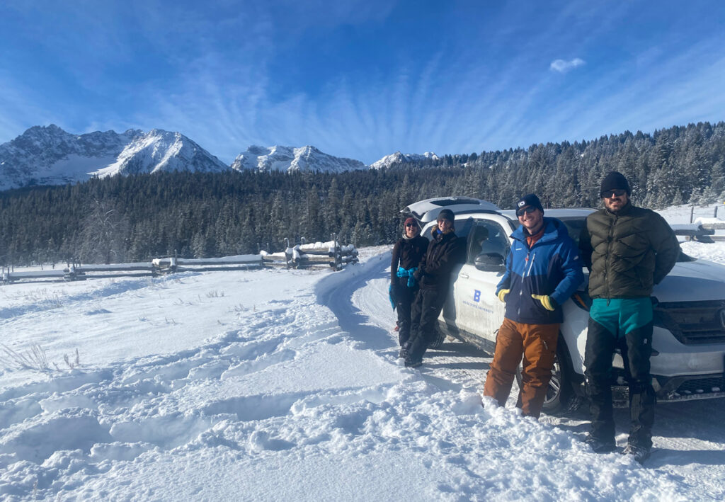
Volcán Villarrica, near Pucon, Chile, is seen in 2025 (left). The volcano regularly releases gas from a small lava lake recessed deep within the summit crater (right). Credit: Jeffrey B. Johnson
The Gem’s inaugural field mission came in January 2020 during a return to Villarrica, where activity had returned to normal following its 2015 paroxysmal eruption [Rosenblatt et al., 2022]. Typical activity in the volcano’s normal state includes open-vent degassing from a small lava lake recessed deep within the summit crater, which produces its famously powerful volcano infrasound [e.g., Johnson et al., 2012].
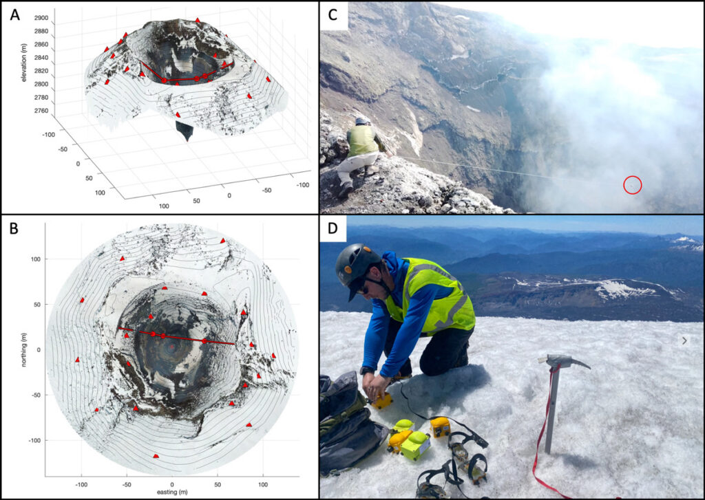
To capture Villarrica’s infrasound in detail, a four-person team from BSU climbed the 3,000-meter-tall glaciated volcano and quickly installed 16 sensors around the crater rim, as well as another 16 sensors along an 8-kilometer linear transect from the summit down the northern slope (Figure 1). This unique sensor distribution permitted us to capture the infrasound wavefield and how it interacts with topography in unprecedented detail.
Fig. 1. (a) Oblique and (b) plan views of Villarica’s summit region were created from structure-from-motion surveys in 2020. Red triangles and circles indicate locations of Gem sensing packages. (c) Also in 2020, Jake Anderson adjusts a cable suspended across the volcano’s crater that held a Gem sensor (circled). (d) In 2025, Jerry Mock unloads Gem systems at Villarica’s summit during another data collection campaign there. Click image for larger version. Credit: Jeffrey B. Johnson
Deploying such an array configuration using much heavier, larger, and power-intensive conventional instruments would have taken far more time and resources, as well as a bigger group. With the Gems, however, the installation was feasible for our small team, each member of which could easily carry eight instruments and the batteries needed to power them.
To monitor volcanoes with infrasound, it is necessary to understand the influence of atmospheric effects.
Once in place, these sensors collected continuous data during the 2-week study that were used to quantify the diffraction of sound coming out of the volcanic crater [Rosenblatt et al., 2022] and to measure the sound’s attenuation as it propagated away. Such studies are important for investigating time-varying atmospheric parameters such as changing temperatures and winds, which can affect infrasound transmission, diminishing its amplitude or even—in extreme cases—completely silencing it in an acoustic shadow zone [Johnson et al., 2012]. To monitor volcanoes with infrasound, it is necessary to understand the influence of atmospheric effects.
Months later, another opportunity arose to demonstrate the Gems’ capability for large-N infrasound sensing. During the early days of the COVID-19 pandemic, on 31 March 2020, a magnitude 6.5 earthquake occurred near Stanley, Idaho. The earthquake, the largest in the state since 1983, kicked off an energetic aftershock sequence, with more than 700 magnitude 3 or greater earthquakes occurring in 6 months. Most of these events produced significant local infrasound radiation, or “airquakes,” caused by ground-atmosphere coupling [e.g., Johnson et al., 2020].
Pandemic-related precautions inhibited a large team from venturing as a group into the field. However, a lone BSU researcher (coauthor Jacob Anderson), trudging through forest terrain and deep snow on skis, was able to deploy and activate 22 Gems in less than 4 hours in early April, thanks in part to the sensors’ compact size and ease of deployment.
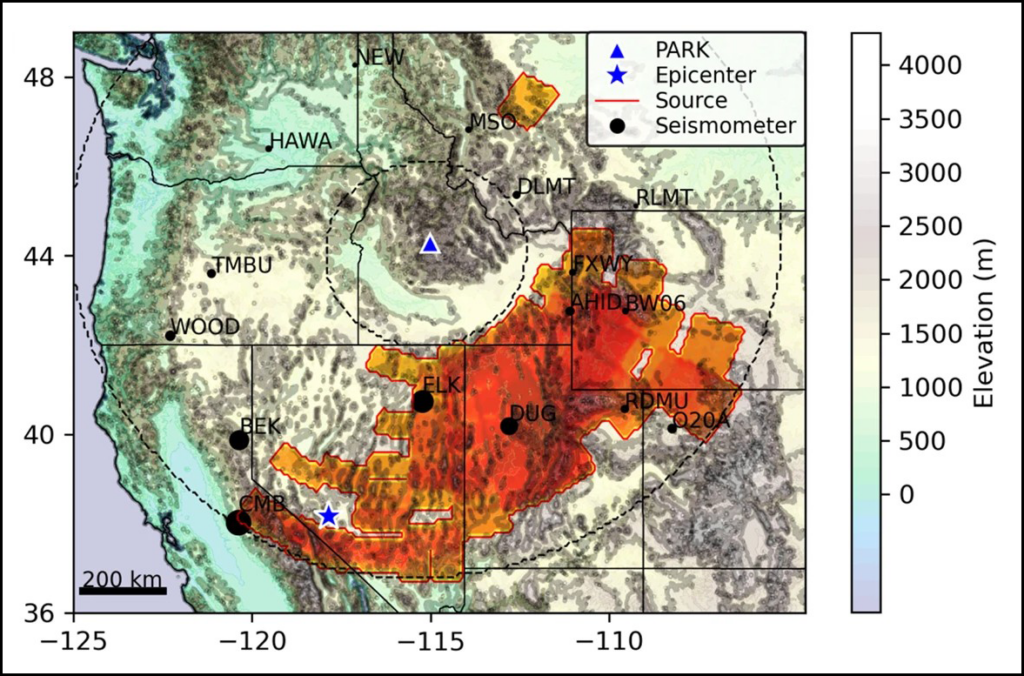
This array captured hundreds of local infrasonic aftershocks within about 25 kilometers of their epicenters. It also recorded a far larger event 700 kilometers away, the 15 May magnitude 6.5 Monte Cristo earthquake in Nevada. The array detected the epicentral infrasound from the distant earthquake source, as well as infrasound from numerous secondary sources, including mountain ranges throughout the western United States that reradiated the ground motion as infrasound (Figure 2) [Anderson et al., 2023].
Fig. 2. This map shows source region(s) of infrasound associated with the May 2020 Monte Cristo earthquake in Nevada that was detected by an array of Gem infrasound sensors deployed at the PARK site near Stanley, Idaho. Click image for larger version. Credit: Adapted from Anderson et al. [2023], CC BY 4.0
Detecting all these distinct signals was possible because of the enhanced array processing capabilities provided by the large number of sensors. Anderson et al. [2023] showed that when the data were processed from 3-sensor subsets of the 20+-sensor array—instead of from the whole array—it was possible to detect only the most intense earthquake infrasound arrivals. In other words, the larger array had much greater fidelity and sensing capabilities than smaller distributions of sensors.
During its 2-month deployment, the Stanley array also detected sounds from other distant nonearthquake sources, including waterfalls 195 kilometers away and thunder more than 900 kilometers away [Scamfer and Anderson, 2023]. Such enhanced detections, facilitated by large-N sensing, demonstrate an improved capacity to monitor a range of Earth phenomena continuously over a wide range of distances.
Putting Sensors in Harm’s Way
Since those proof-of-concept deployments, Gems have been used to monitor snow avalanches, lahars, river flow discharge, stratospheric sounds (while mounted aboard a solar balloon), and numerous volcanoes during field experiments [e.g., Tatum et al., 2023; Bosa et al., 2024; Rosenblatt et al., 2022; Brissaud et al., 2021]. Given their ease of use, small size, and low replacement cost, they’ve also been tested in hazardous environments where the risk to more expensive hardware could be considered unreasonable.
The motivation to put sensors in harm’s way is to gain insight into geophysical phenomena by recording subtle signals close to the source that may not be detectable from farther away.
The motivation to put sensors in harm’s way is to gain insight into geophysical phenomena by recording subtle signals close to the source that may not be detectable from farther away. For example, at Villarrica, Rosenblatt et al. [2022] suspended a Gem on a cable 100 meters above a lava lake to collect infrasound data from a unique, bird’s-eye perspective over the crater (Figure 1c). (Stringing the cable across the crater proved far more challenging than deploying the sensor itself, which slid down the cable until finding its resting place at the bottom of the cable’s arc.)
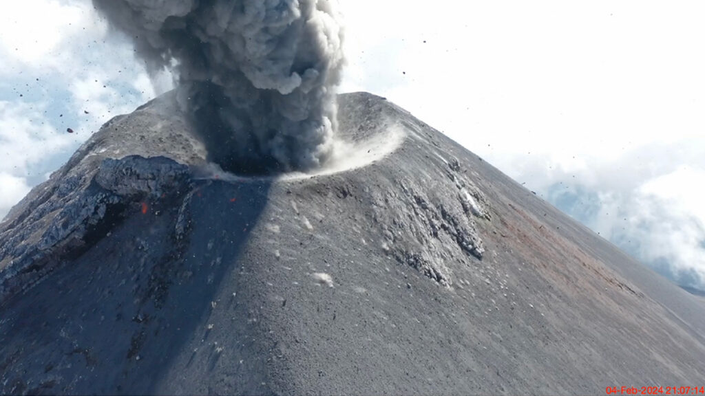
In another case, we landed a pair of Gems on the ground near a frequently exploding crater at Fuego volcano in Guatemala using a drone (see video below). We later retrieved one of the sensors from high on the volcano’s flanks. Another was lost because high winds initially posed too great a risk to fly the drone back for it. Then the following day after the wind subsided, we could not locate the stranded Gem, which was probably a casualty of a nighttime explosion.
Drone footage and infrasound recordings were collected during an explosion of Fuego volcano on 4 February 2024. Pa = pascals. Credit: video: Jerry C. Mock; animation and infrasound: Jeffrey B. Johnson
Our group at BSU also has nascent interest in using Gems to study fire in natural environments. Wildfires produce infrasound from a spatially extensive source region corresponding to actively burning areas. Because of the source complexity and the fact that fire infrasound is low amplitude and tremor-like [Johnson et al., 2025], enhancing signal-to-noise ratios in recorded infrasound is critical. This enhancement is enabled by using large-N monitoring networks, making infrasound wildfire surveillance a promising area of investigation.
Low-cost, rapid infrasound deployments could one day be used as an effective operational tool.
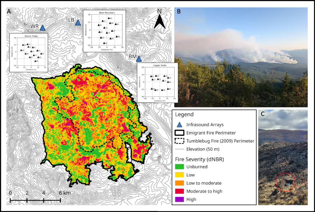
Toward this objective, our group installed 76 sensors ahead of a prescribed burn in Reynolds Creek, Idaho, in October 2023 to begin developing infrasound as a tool for monitoring and mapping wildfire. We have also deployed Gems for infrasound studies of naturally occurring wildfires, such as the Emigrant wildfire in Oregon in August and September 2025 (Figure 3). During that active wildfire response, a team safely and quickly installed tens of sensors within a matter of hours in an area facing dynamic hazards from the rapidly expanding fire, which eventually covered 33,000 acres (about 13,354 hectares). Luckily, no instruments were lost, and the data have shown the potential to track a wildfire as it advances.
Preliminary results suggest that low-cost, rapid infrasound deployments could one day be used as an effective operational tool. For example, in firefighting responses, infrasound might complement intermittent aerial observations, from aircraft or drones, because it provides a continuous record of fire activity. Infrasound surveillance might also be able to “hear” combustion sources within a burn area that is obscured to optical sensing because of clouds or nightfall.
Fig. 3. (a) The spread and severity of the 2025 Emigrant Fire in Oregon, as calculated from prefire (21 August) and postfire (18 October) Sentinel-2 satellite images, are shown. Inset maps show the distribution of 37 Gem sensors rapidly deployed in three arrays. (b) Smoke from the fire rises from the landscape on 31 August during deployment of the sensors. (c) Following the fire, one sensor that had been melted by the fire was recovered with its data card still intact (red circle). dNBR = differenced normalized burn ratio. Click image for larger version. Credit: (a) and (b): Madeline A. Hunt; (c): Jacob F. Anderson
The Evolution of Low-Cost Sensors
Five years ago, the single-sensor Gem was a cutting-edge infrasound logging solution. While it remains a powerful and economical tool for large-N arrays and for sensing in hostile environments, it is evolving.
Boise State University researchers (left to right) Madeline Hunt, Owen Walsh, Jerry Mock, and Jacob Anderson prepare to deploy Gem sensors in Idaho’s Sawtooth Mountains in January 2024. Credit: Jeffrey B. Johnson
We have now developed the Gem into an even more versatile version called the Aspen, which can log four independent sensors at a sample rate of 200 hertz, double that of the Gem. The Aspen retains the small size, low weight, low power consumption, and low cost of the Gem, but with the capability to record higher-resolution 24-bit, time-synchronized data from a triaxial seismic sensor and an infrasound transducer.
Recording synchronous seismoinfrasonic data on the same logging platform offers the advantage of sensing both ground shaking and infrasonic oscillations. The ability to measure waves propagating in the ground and in the air simultaneously could facilitate work in the growing field of environmental seismology, which focuses on geophysical sources at Earth’s surface like debris flows and volcanoes.
Although we have focused on seismoacoustic geophysical measurements in our work, the concept of gathering data with low-cost instrumentation in harm’s way or from coordinated arrays of numerous sensors holds promise across Earth and environmental sciences. Such approaches could be used, for example, with tiltmeters (which measure slope changes), gravity meters, or near-infrared thermometers (e.g., optical pyrometers), all of which would offer additional data streams complementing seismoacoustic observations in geophysical studies of volcanoes.
With the diversity of emerging uses, it’s clear that large-N sensing—infeasible or cost prohibitive in many cases until recently—could transform how we measure many facets of Earth, helping to reveal the inner workings of volatile volcanoes, twisting tornadoes, and more.
Acknowledgments
More information about low-cost infrasound sensing solutions can be found at https://sites.google.com/boisestate.edu/infravolc/home. Development of the Gem infrasound logging platform was supported by a grant from the National Science Foundation (EAR-2122188).
References
Anderson, J. F., et al. (2018), The Gem infrasound logger and custom‐built instrumentation, Seismol. Res. Lett., 89(1), 153–164, https://doi.org/10.1785/0220170067.
Anderson, J. F., et al. (2023), Remotely imaging seismic ground shaking via large-N infrasound beamforming, Commun. Earth Environ., 4(1), 399, https://doi.org/10.1038/s43247-023-01058-z.
Bosa, A. R., et al. (2024), Dynamics of rain-triggered lahars and destructive power inferred from seismo-acoustic arrays and time-lapse camera correlation at Volcán de Fuego, Guatemala, Nat. Hazards, 121, 3,431–3,472, https://doi.org/10.1007/s11069-024-06926-1.
Brissaud, Q., et al. (2021), The first detection of an earthquake from a balloon using its acoustic signature, Geophys. Res. Lett., 48, e2021GL093013, https://doi.org/10.1029/2021GL093013.
Johnson, J. B., et al. (2012), Probing local wind and temperature structure using infrasound from Volcan Villarrica (Chile), J. Geophys. Res., 117, D17107, https://doi.org/10.1029/2012JD017694.
Johnson, J. B., et al. (2018), Forecasting the eruption of an open-vent volcano using resonant infrasound tones, Geophys. Res. Lett., 45, 2,213–2,220, https://doi.org/10.1002/2017GL076506.
Johnson, J. B., et al. (2020), Mapping the sources of proximal earthquake infrasound, Geophys. Res. Lett., 47, e2020GL091421 , https://doi.org/10.1029/2020GL091421.
Rosenblatt, B. B., et al. (2022), Controls on the frequency content of near-source infrasound at open-vent volcanoes: A case study from Volcán Villarrica, Chile, Bull. Volcanol., 84(12), 103, https://doi.org/10.1007/s00445-022-01607-y.
Scamfer, L. T., and J. F. Anderson (2023), Exploring background noise with a large‐N infrasound array: Waterfalls, thunderstorms, and earthquakes, Geophys. Res. Lett., 50, e2023GL104635, https://doi.org/10.1029/2023GL104635.
Slad, G., and B. Merchant (2021), Evaluation of Low Cost Infrasound Sensor Packages, Sandia Rep. SAND2021-13632, Sandia Natl. Lab., Albuquerque, N.M., https://doi.org/10.2172/1829264.
Tatum, T., J. F. Anderson, and T. J. Ronan (2023), Whitewater sound dependence on discharge and wave configuration at an adjustable wave feature, Water Resour. Res., 59, e2023WR034554, https://doi.org/10.1029/2023WR034554.
Author Information
Jeffrey B. Johnson (jeffreybjohnson@boisestate.edu), Jacob F. Anderson, Madeline A. Hunt, Owen A. Walsh, and Jerry C. Mock, Department of Geosciences, Boise State University, Idaho
Citation: Johnson, J. B., J. F. Anderson, M. A. Hunt, O. A. Walsh, and J. C. Mock (2026), Sensing the sounds from Earth’s hazardous environments, Eos, 107, https://doi.org/10.1029/2026EO260142. Published on 8 May 2026.
All of that is correct. But it misses a structural problem inherent in agency governance, one that will recur at every reorganization until the Earth science community builds an instrument to prevent it.
In massive reorganizations like the ones federal agencies are currently experiencing, the threat to long-term research facilities is not primarily a lack of funding. The true threat is an oversight of administrative architecture. There appears to be no general federal requirement to have a successor stewardship plan in place before reducing the output or outreach of a long-term research facility—or closing it entirely.
The Physical Archive Is Not a Digital File
Hubbard Brook Experimental Forest in New Hampshire was among the sites under review during the Forest Service restructuring but has since received a public reprieve. The future of Bartlett Experimental Forest, also in New Hampshire, remains unresolved. The governance problem, however, extends beyond either site.
Hubbard Brook’s physical archive holds more than 60,000 barcoded and cataloged samples: water, soils, plant material, and physical cores spanning 7 decades of continuous collection and stored under active environmental controls in a dedicated building on site.
These samples cannot be digitized. They cannot be migrated to a remote server, backed up to cloud storage, or emailed to a university partner. The samples require a functioning building, active temperature management, and a named human steward responsible for their integrity.
The physical archive at Hubbard Brook holds more than 60,000 barcoded and cataloged samples stretching back to the founding of the facility in 1955. Credit: Anthony Veltri
The archive includes core samples of trees dating to long before the experimental forest was established, and the archive maintains each as a managed scientific record with continuity of custody. Credit: Anthony Veltri
Core samples like these document the watershed at Hubbard Brook and anchor long-term understanding of system processes. Credit: Anthony Veltri
The archive at Hubbard Brook is impressive, but a governed record is defined by continuity, provenance, and stewardship, not by the number of observations it contains: Data volume is not data value. A 70-year unbroken record of watershed chemistry, maintained by named stewards who documented what they were measuring and why, is a governed product. Without that stewardship and physical anchor, volume can become noise.
The failure to maintain archives like this is likely not malicious; it is an example of administrative indifference or perhaps a lack of awareness or understanding. Environmental controls, for example, get zeroed out of a budget line item, and nobody notices until the temperature in the facility drifts. By then, the sample record has degraded in ways that cannot be reversed.
This Is Not a Hubbard Brook Problem
Many physical archives, calibration sites, and long-duration sampling programs operate without a formal requirement for stewardship continuity.
Hubbard Brook is the most visible instance of a pattern—the lack of a successor stewardship plan—that runs across the entire 84-site federal Experimental Forests, Ranges, and Watersheds network. The March order that identified Bartlett Experimental Forest and 56 other research facilities across 31 states for closure was executed without a mandatory requirement to identify successor stewards for what gets left behind.
Nor is the pattern unique to experimental forests. The Long Term Ecological Research network spans 28 core sites. AmeriFlux includes more than 500 monitoring locations across North America.
Throughout all these systems, many physical archives, calibration sites, and long-duration sampling programs operate without a formal requirement for stewardship continuity under agency reorganization.
What We Stand to Lose
Long-term physical archives provide scientists and other stakeholders the ability to ask future questions of past reality. Nobody collecting water samples at Hubbard Brook in 1963 was thinking about PFAS (per- and polyfluoroalkyl substances), for instance, but the baseline its site samples provide is why we can track the chemicals today. The same continuous record was central to the regulatory science behind the Clean Air Act amendments of 1990.
Archival value compounds silently and becomes visible only when someone needs it.
Archival value compounds silently for decades and becomes visible only when someone needs it.
When these archives fail, the loss is not historical. It is operational. Regulatory agencies rely on long-baseline records to determine whether interventions are working. Without a continuous physical reference, observed changes cannot be distinguished from measurement drift, instrumentation bias, or natural variability. The results are policy decisions made without a defensible scientific baseline.
Federal investment in continuous collection at a site like Hubbard Brook runs to tens of millions of dollars over decades. That investment is not recoverable once continuity is broken.
Unlike a paused research grant, a degraded physical archive cannot be restarted. You can photograph a sample, but you cannot rerun its chemistry 40 years from now if the physical sample has degraded.
In 2017, a double mechanical failure at the University of Alberta destroyed 12.8% of the Canadian Ice Core Archive over a single weekend, permanently erasing records dating back 12,000 years. That incident was accidental. A mechanical malfunction is a failure of equipment. Administrative disposal without a named successor steward is a failure of governance. One arrives without warning. The other can be prevented.
The Community Already Knows How to Do This
The Earth observation community has already built the governance model we need. We are not yet applying it to long-term ecological research infrastructure.
GRUAN, the Global Climate Observing System (GCOS) Reference Upper-Air Network, operates under the World Meteorological Organization and GCOS, with explicit named stewardship obligations. Upper-air observations—measurements of temperature, humidity, and wind through the atmosphere—are foundational inputs to weather forecasting and climate monitoring. Each GRUAN station has a designated principal investigator with a documented succession obligation.
ICOS, the Integrated Carbon Observation System operating across Europe, applies the same logic to terrestrial ecosystem observations through formal site-level stewardship agreements and named succession requirements.
In the United States, the National Ecological Observatory Network is funded by the National Science Foundation (NSF) and operated by Battelle, a science and technology nonprofit, under a contract that includes explicit data continuity obligations.
These systems did not emerge by accident. They were explicitly designed to solve a known failure mode: Distributed observational networks cannot maintain their own calibration integrity without a separately governed reference layer. That design decision is documented, enforced, and funded. The absence of an equivalent requirement in long-term ecological research infrastructure is not a technical limitation. It is a governance omission.
The pattern is consistent across every network that has solved this problem: Named continuity obligations must be written into the governance structure before the need becomes acute.
The Governance Instrument
The best outcome is the continued, uninterrupted operation of facilities like Hubbard Brook.
Any federal agency action that would reduce operational support for a long-term research facility should require a formal continuity plan before the action takes effect.
If reductions move forward, however, the proposed fix is specific and not novel: Any federal agency action that would reduce or eliminate operational support for a long-term research facility should require a formal continuity plan before the action takes effect. That plan must name a successor steward for each active long-term dataset and for each physical archive under active environmental control.
In practice this means specificity: the name and institutional affiliation of the successor, a funded maintenance budget sufficient to sustain environmental controls and sample integrity, documented protocols for custody transfer, and a timeline for uninterrupted handoff. The plan must demonstrate that the successor steward has the operational capacity and funded mandate to preserve the archive’s physical integrity and continuity.
This instrument prepares plant samples collected at Hubbard Brook using standardized methods. Consistent preparation is what makes results comparable across time and labs and why continued stewardship is so important. Credit: Anthony Veltri
The default should be continued stewardship by the responsible federal entity. If a change in custody is legally permitted and genuinely unavoidable, any successor steward, whether another federal unit, a university partner, a consortium, or another entity, must have a funded mandate, demonstrated technical capacity, enforceable continuity obligations, and the ability to maintain the archive without interruption.
Protocol demands that if the agency cannot name a viable successor steward, the agency cannot execute the closure. This requirement does not prohibit closure; it prohibits closure without continuity of custody.
The instrument requiring a research facility to have a formal continuity plan should be applied not on a site-by-site basis, but uniformly across networks. A limitation narrowly written to protect a named facility invites the agency to execute the same administrative disposal at adjacent sites while technically complying with the specific requirement. The governance is structurally sound only if it applies across the network.
How This Actually Happens
The pathways that would make such an instrument possible already exist.
Agencies can impose continuity requirements through policy directives, appropriations language, or funding conditions. The federal Office of Science and Technology Policy and the Office of Management and Budget have coordinated interagency data management guidance before, and a directive requiring named successor stewardship before any facility reduction does not require legislation. Sen. Jeanne Shaheen (D-NH) has already secured fiscal year 2026 language directing the Forest Service to prioritize staffing at long-standing experimental forests; attaching successor stewardship language is the logical next step. NSF, the Department of Energy, and NOAA could require stewardship continuity guarantees from partner agencies as a condition of incorporating facility data into federally funded continental-scale products.
Scientists recognize that agencies reorganize and funding for facilities can be downgraded. That is why preserving a continued record of any long-term research facility must be part of the facility’s governance structure from the outset. Credit: Anthony Veltri
What is missing is the requirement itself—and the strategic initiative to establish it. The Earth science community has the standing, the documented models, and the mechanisms to close those gaps.
This is not an argument against reorganization. Agencies reorganize. Budgets shift. Research priorities evolve.
The argument is that reorganization cannot be permitted to destroy multigenerational scientific infrastructure through administrative indifference when a specific, enforceable governance requirement can prevent it. The Earth observation community built GRUAN because it recognized that no federation of climate datasets can be a substitute for a governed anchor point. Long-term ecological research infrastructure needs the same recognition applied to the administrative layer that governs its continuity.
The scientific enterprise already knows how to do this. The governance has not caught up yet.
Author Information
Anthony Veltri (anthony@anthonyveltri.com) is an independent practitioner and former physical scientist and senior policy analyst with the USDA Forest Service Washington Office, where he worked on enterprise architecture and governance in federal programs, including those supporting scientific research.
Citation: Veltri, A. (2026), The governance gap threatening long-term ecological archives, Eos, 107, https://doi.org/10.1029/2026EO260172. Published on 27 May 2026.
This article does not represent the opinion of AGU, Eos, or any of its affiliates. It is solely the opinion of the author(s).
As businesses grow, their technology needs grow with them. What once worked for a small team—basic infrastructure, limited security controls, and ad hoc support—quickly becomes insufficient when operations expand, teams become distributed, and digital systems grow more complex. At this stage, technology is no longer just a support function; it becomes a core driver of performance, efficiency, and scalability. Managed IT Providers play a critical role in helping businesses navigate this transition with stability and confidence.
By offering ongoing IT support, strategic guidance, and proactive system management, managed IT providers enable organizations to scale their operations without being slowed down by technical limitations or unexpected disruptions. Their role extends beyond troubleshooting issues—they help build and maintain the technological foundation that allows businesses to grow sustainably.
Building a Scalable Technology Foundation
One of the most important contributions managed IT providers make is establishing a scalable IT infrastructure. As companies expand, they often encounter challenges such as increased data volume, more users accessing systems, and the need to integrate new tools and platforms. Without a scalable architecture, these demands can strain existing systems and lead to performance issues.
Managed IT providers design and manage environments that can adapt to growth. Whether it involves cloud migration, hybrid infrastructure, or optimizing on-premises systems, they ensure that technology aligns with the organization’s growth trajectory. This includes selecting the right platforms, configuring networks for performance, and ensuring systems can handle increased workloads without degradation.
By taking a forward-looking approach, managed IT providers help businesses avoid the need for frequent overhauls or reactive upgrades. Instead, technology evolves in step with the organization, supporting expansion rather than hindering it.
Proactive Monitoring and Issue Prevention
As businesses scale, the cost of downtime and system disruptions becomes more significant. Even minor outages can impact productivity, customer experience, and revenue. Managed IT providers address this risk through proactive monitoring and maintenance.
Rather than waiting for issues to occur, managed IT providers continuously monitor systems, networks, and applications to identify potential problems before they escalate. This includes tracking system performance, detecting anomalies, and applying updates or patches as needed to maintain stability.
This proactive approach reduces the likelihood of unexpected disruptions and ensures that systems remain reliable as usage increases. For growing businesses, this reliability is essential. It allows teams to focus on their work without being interrupted by technical issues, and it provides leadership with the confidence that operations can continue uninterrupted.
Strengthening Cybersecurity as the Business Expands
As organizations grow, their exposure to cybersecurity risks also increases. More users, more devices, and more data create a larger attack surface for potential threats. At the same time, cyberattacks are becoming more sophisticated, making it increasingly difficult for internal teams to manage security without specialized expertise.
Managed IT providers help businesses scale securely by implementing comprehensive cybersecurity strategies. This includes deploying firewalls, endpoint protection, intrusion detection systems, and access controls that align with best practices. They also monitor for suspicious activity and respond to threats in real time.
In addition to technical safeguards, managed IT providers help establish security policies and user practices that reduce risk across the organization. As businesses expand into new markets or adopt new technologies, maintaining a consistent security posture becomes more complex. Managed IT providers ensure that security scales alongside the business, protecting sensitive data and maintaining trust with customers and partners.
Enabling Operational Efficiency Through Standardization
Growth often introduces complexity, especially when different teams adopt different tools or processes. Without standardization, IT environments can become fragmented, leading to inefficiencies, compatibility issues, and increased support demands.
Managed IT providers help address this challenge by standardizing systems, processes, and configurations across the organization. By aligning technology with business objectives, they ensure that tools are integrated, workflows are consistent, and systems communicate effectively with one another.
This standardization simplifies IT management and reduces friction for employees. When systems are consistent and well-integrated, onboarding new users becomes easier, troubleshooting becomes faster, and collaboration becomes more seamless. For leadership, it also provides greater visibility into how technology is being used across the organization, making it easier to plan for future growth.
Providing Strategic IT Guidance for Growth Planning
Scaling a business is not just about adding more resources—it requires thoughtful planning and alignment between technology and business goals. Managed IT providers act as strategic partners in this process, offering guidance on how to leverage technology to support expansion.
This may involve recommending infrastructure upgrades, advising on cloud adoption strategies, or identifying opportunities to automate processes. Managed IT providers bring experience from working with multiple organizations across industries, allowing them to provide insights into what approaches are most effective in different growth scenarios.
By aligning IT strategy with business objectives, they help organizations make informed decisions about investments in technology. This ensures that resources are allocated efficiently and that technology choices support long-term scalability rather than short-term fixes.
Supporting Remote and Distributed Teams
As businesses grow, they often expand beyond a single physical location. Remote work, hybrid environments, and geographically distributed teams have become increasingly common. While this flexibility supports growth, it also introduces challenges in terms of connectivity, security, and collaboration.
Managed IT providers help businesses support distributed teams by implementing solutions that enable secure remote access, reliable communication, and consistent user experiences. This includes managing cloud-based systems, configuring virtual private networks, and ensuring that collaboration tools are properly integrated and maintained.
With the right IT infrastructure in place, employees can access the systems and information they need from anywhere, without compromising security or performance. This capability allows organizations to expand their talent pool, support multiple locations, and maintain productivity regardless of where employees are working.
Reducing Internal IT Burden and Allowing Focus on Core Business
As organizations scale, internal IT teams often face increasing demands. Without additional support, these teams can become overwhelmed by day-to-day maintenance, troubleshooting, and system management tasks. This can limit their ability to focus on strategic initiatives that drive business value.
Managed IT providers alleviate this burden by handling routine IT operations, monitoring, and support functions. This allows internal teams to concentrate on projects that require deeper alignment with business goals, such as digital transformation initiatives, system integrations, or process improvements.
By extending the capabilities of internal teams, managed IT providers create a more balanced and efficient IT environment. Businesses benefit from both the strategic insight of internal staff and the operational expertise of external specialists, resulting in a more comprehensive approach to technology management.
Conclusion
Scaling a business successfully requires more than just increasing revenue or expanding operations—it requires a technology foundation that can grow alongside the organization. Managed IT providers play a vital role in making this possible by delivering scalable infrastructure, proactive support, enhanced security, and strategic guidance.
Their involvement allows businesses to navigate growth with greater confidence, minimizing risks while maximizing efficiency and performance. As organizations continue to evolve in an increasingly digital and interconnected world, managed IT providers serve as essential partners in ensuring that technology remains an enabler of growth rather than a barrier to it.
SIPITANG, June 13 — The implementation of the Sabah Southern Madani Link (SSML) electricity grid project demonstrates the federal government’s commitment to ensuring that development initiatives and basic amenities reach communities in Sabah’s interior regions.
Prime Minister Datuk Seri Anwar Ibrahim said the project is in line with the Malaysia Madani policy, which emphasises fair and equitable development, rather than concentrating progress solely in major urban centres.
He said genuine development would not have a comprehensive impact if basic facilities continued to bypass remote areas, particularly in Sabah’s interior.
“That is why I am deeply concerned and want to ensure that development is distributed evenly throughout every part of the state, including the interior. This is what distinguishes our approach from that of some other countries, where development is focused only on major cities,” he said when officiating the groundbreaking ceremony for the SSML project here.
Also present were Chief Minister Datuk Seri Hajiji Noor, Domestic Trade and Cost of Living Minister Datuk Armizan Mohd Ali, and Minister in the Prime Minister’s Department (Sabah and Sarawak Affairs) Datuk Mustapha Sakmud.
The SSML project involves the construction of a 275-kilovolt (kV) electricity transmission line linking Sabah’s west and east coasts, playing a crucial role in strengthening the state’s power supply grid and balancing energy distribution across Sabah.
The project, which commenced on September 17 last year, is scheduled for completion on September 16, 2028, at a cost of RM198 million. As of May 26, the project had reached 17 per cent completion.
Anwar said the energy grid project carries significant importance as it requires the dedication and perseverance of workers who traverse the dense forests of southern Sabah to build electricity infrastructure for the people.
“I am moved and pleased to see those transmission towers stretching across the wilderness. Imagine the workers whose job requires them to enter the forests and leave their families behind, all to develop electricity supply infrastructure for the people of Sabah. To all of you, I extend my deepest appreciation for this sacrifice,” he said.
Commenting on criticism from certain quarters in Parliament over the substantial development allocations for Sabah and Sarawak, the prime minister said the government stood by its decision as part of efforts to narrow infrastructure development gaps in the two states. — Bernama
Every chip fabricated in a semiconductor plant needs ultrapure water. Most nuclear reactors need water as a coolant and neutron moderator. Every artificial intelligence (AI) data center drinks between 1 million and 5 million gallons of water a day, with thirst often peaking during drought.
Water runs through every technology priority the United States has named, yet the word does not appear once in “Launching the Genesis Mission,” an executive order (EO) released in November 2025. As described in the EO, the Genesis Mission is a “dedicated, coordinated national effort to unleash a new age of AI-accelerated innovation and discovery that can solve the most challenging problems of this century.”
Led by the Department of Energy (DOE), the initiative aims to build an integrated AI framework that would harness federal scientific datasets to accelerate breakthroughs in advanced manufacturing, biotechnology, critical materials, nuclear fission and fusion energy, quantum information science, and semiconductor development. The scope of the mission is comparable to that of the Manhattan Project.
Since the announcement, the DOE has listed “Predicting U.S. Water for Energy” among its 26 Genesis Mission Science and Technology Challenges. The project is also soliciting proposals in three water-related focus areas.
This framework provides a foothold for hydrology in the Genesis Mission, but it is scoped narrowly around water as a supply variable for energy production.
In reality, water is a crosscutting constraint that will help determine whether the mission’s priorities translate into deployable outcomes. The hydrology community now has a seat at the table, and if it moves first and positions water security as one of the “most challenging problems of this century,” the Genesis Mission can become the sandbox in which AI reshapes how the country measures, models, and manages water.
Making this happen will require that the DOE and the Office of Science and Technology Policy charter a hydrology workstream inside the Genesis Mission, with interagency delivery involving the U.S. Geological Survey (USGS), NOAA, the Bureau of Reclamation, the EPA, and partners at state, regional, and community levels. Here is what we think that workstream should look like:
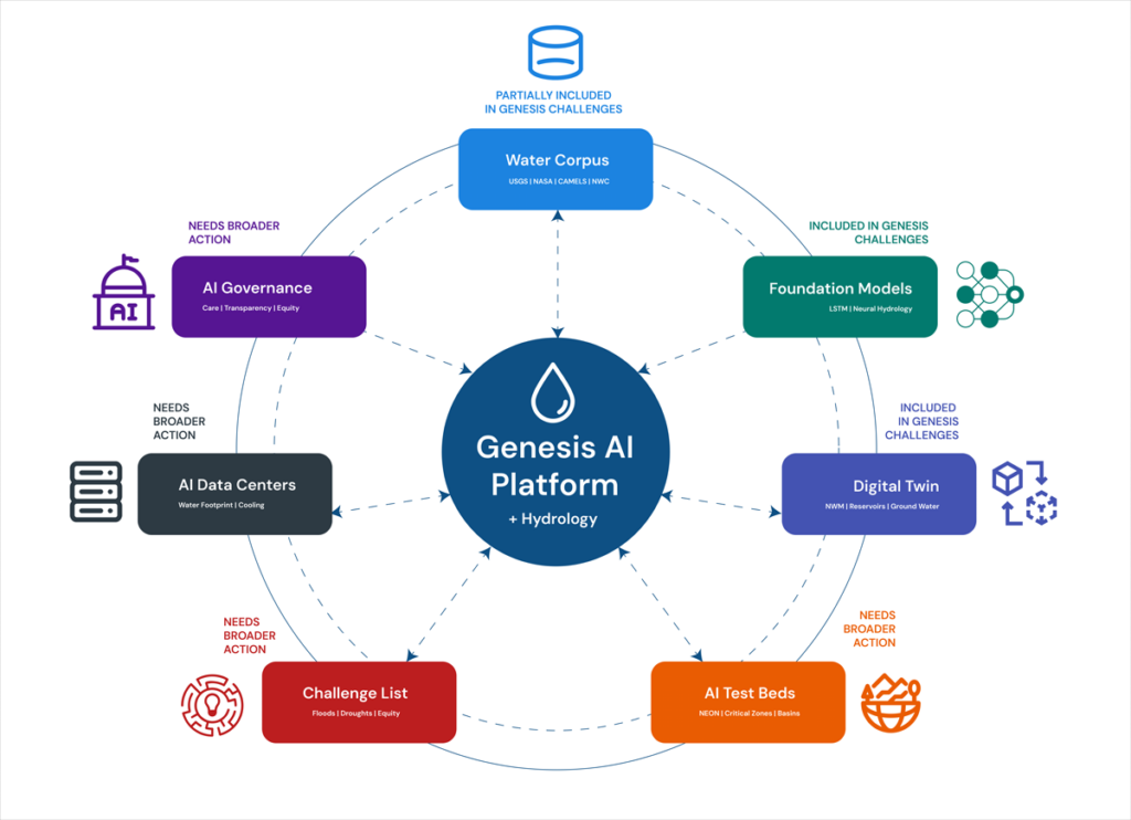
A water-centric Genesis Mission architecture supports seven hydrological components that both feed into and receive decisions from the Genesis AI platform. Each component maps to a section of this article. Credit: Amobichukwu C. Amanambu. Click image for larger version.
While the existing challenges reflect some of these components, others will require coordinated effort from the hydrology community to bring into the Genesis Mission’s scope.
Build the Water Corpus Genesis Will Need
The Genesis Mission EO instructs the DOE to create an American Science and Security Platform to provide the public, scientists, agencies, and policymakers access to crucial scientific datasets.
The good news is that accessible water data systems already exist across several federal agencies and academic research centers. The USGS National Water Information System tracks real-time and historical water quality and use across the country. NASA’s Earth Science Data Systems Program provides open access to Earth science observations. NOAA’s National Water Center, the first federal facility dedicated to national water resource forecasting, operates the National Water Model, which continuously forecasts flows on 2.7 million stream reaches across the continental United States. The Catchment Attributes and Meteorology for Large-Sample Studies (CAMELS) dataset, currently hosted by the National Center for Atmospheric Research, provides data tailored for hydrological research on hundreds of river basins, and the Caravan framework pulls together multiple large-sample meteorological and hydrological datasets at a global scale.
What is missing is a unified, AI-ready repository that brings federal, state, and community data together.
What is missing is a unified, AI-ready repository that brings federal, state, and community data together. Building one is hard. Water data are fragmented, inconsistent, and often entirely absent. Consistent, reliable data for groundwater, withdrawals, reservoir operations, and water quality are especially difficult to obtain.
Local resistance to sharing data is real. In Texas, for example, landowners hold private property rights over groundwater and have opposed metering and reporting requirements imposed by groundwater conservation districts. In California, agricultural well owners fought metering mandates for years before the Sustainable Groundwater Management Act compelled local agencies to begin tracking withdrawals. Tribal nations face a different concern: Water data collected on Indigenous lands has been misrepresented in federal datasets that were modeled without accounting for Indian country, leading many nations to restrict access to their data as an exercise of sovereignty.
Practical steps toward building a unified AI-ready repository include tiered access and licensing for different stakeholders, clear provenance tracking for all data reported, financial and educational incentives for stakeholders for reporting, and targeted gap filling. Where measurements are missing, AI can fuse remote sensing with gauged records and operational logs—but only if the results carry honest uncertainty estimates tied to real decisions.
Get the corpus right, and it will outlive any single program name. It becomes infrastructure the country can lean on.
Develop Shared Hydrologic Foundation Models
The Genesis Mission EO directs the DOE to provide “domain-specific foundation models across the range of scientific domains covered.”
Hydrology has a head start. Long short-term memory (LSTM) networks are a key type of neural network designed to last thousands of time steps. Hydrology LSTMs trained on CAMELS data have already matched traditional conceptual models for daily streamflow discharge prediction. Open-source Neural Hydrology tools serve as baselines for regional runoff prediction. These predictions may serve as precursors to the foundation models the Genesis Mission envisions and building blocks from which they could be developed.
The process of scaling up these tools is not straightforward, however. A hydrologic investigation of snowmelt-driven streams in Colorado will not require the same spatiotemporal data as tile-drained fields in Iowa, for example. A hydrology-specific foundation model must take nuanced requirements into consideration and provide a clear path for managing and exploiting a variety of datasets.
Google’s Flood Hub shows what is possible: Its AI-enabled flood forecasts now cover more than 80 countries. However, Flood Hub’s core model code and trained weights remain proprietary, meaning researchers can use the forecasts but cannot rebuild or adapt the underlying models. Genesis, if well positioned, can fill that accessibility gap by producing foundation models for water that are reusable, reliable, and openly governed.
Build a National Water Digital Twin
The EO prescribes an integrated AI platform combining foundation models with simulation tools to stimulate AI-enabled innovations.
That architecture is exactly what a digital twin requires. Europe’s Destination Earth initiative is already building digital twins for weather extremes and nonstationary conditions on the Large Unified Modern Infrastructure (LUMI) supercomputer. The United Nations–led AI for Good initiative has prioritized water applications, warning that fragmented national efforts risk duplicating work.
If the United States aims for global strategic leadership in AI-accelerated science, water infrastructure cannot be an afterthought.
A water digital twin earns its keep when it makes the consequences of choices visible, in terms of flows, levels, temperatures, and risks to people and ecosystems.
Rather than starting from scratch, a water-centric Genesis Mission would unite existing federal models—the National Water Model, reservoir simulators, and groundwater codes—in a single digital twin. AI can become the thread that stitches them together, correcting biases and providing numerical solvers to enforce mass and energy balance.
What should this twin actually do? Help a dam operator decide whether to release water ahead of a storm. Tell planners where a new data center can draw cooling water without drying up a stream. Flag which coastal defenses will fail first under rising seas.
A water digital twin earns its keep when it makes the consequences of choices visible, in terms of flows, levels, temperatures, and risks to people and ecosystems.
Turn Basins into AI Test Beds
The Genesis Mission promotes AI-directed experimentation and directs the DOE to keep a record of robotic laboratories and production facilities in which such experimentation could be conducted. Hydrological field sites belong in that inventory. The National Ecological Observatory Network already operates 81 sites with standardized measurements of meteorology, surface water, groundwater, and biodiversity. The Critical Zone Collaborative Network instruments catchments to track water-soil-vegetation interactions over decades.
Formalizing these networks as AI test beds would link field observations back into the water digital twin so that experiments and models continually sharpen each other. Imagine mobile sensors steered by AI agents during a storm or aquifer recharge experiments designed by algorithms and verified in real time. That feedback loop is what separates a useful model from a decorative one.
Expand Water Challenges on the Genesis Mission List
The Exchange and What’s at Stake
Allowing water security to flow through the diverse components of the Genesis Mission would benefit both the policies championed by the mission itself and the hydrology community.
The Genesis Mission gets real-world, noisy test beds where AI proves value beyond benchmarks, a domain to stress test climate and infrastructure investments, and scientists trained in both AI and the stubborn realities of rivers, aquifers, and pipes.
Hydrology gets resources for shared data infrastructure, foundation models and instrumented basins no single lab can support, a seat when rules for AI and national scientific infrastructure are negotiated, and a chance to reset practices around openness, collaboration, and equity.
Earlier this year, the DOE released 26 Genesis Mission Science and Technology Challenges, and “Predicting U.S. Water for Energy” was among them. The accompanying funding call (DE-FOA-0003612) solicits proposals on cloud microphysics, coupled surface water–groundwater modeling, and seasonal to multiyear prediction, all framed around energy needs and flood resilience.
These inclusions are a significant win for a hydrology component to Genesis, but several urgent challenges sit outside their scope. Can AI close the gap between a flood forecast issued 12 hours out and the 48 hours emergency managers actually need? Can it map compound extremes, in which drought, heat, and infrastructure failure collide in the same week? Can it redesign monitoring networks so that coverage follows risk rather than where gauges happened to be installed a century ago? Integrating energy and water systems is equally urgent: Floods have caused 80% of major U.S. grid outages since 2000, while drought-driven water stress curtails cooling at thermoelectric plants and reduces hydropower output, exposing how deeply energy infrastructure depends on hydrologic extremes.
The water footprint of new AI infrastructure deserves a place on that list. A separate executive order (14318, “Accelerating Federal Permitting of Data Center Infrastructure”) is already fast-tracking expansion of data center construction, and a single hyperscale facility can consume 1 million to 5 million gallons of water daily. Emerging research shows how withdrawals at that scale can push streams below ecological thresholds during low flows.
Make Hydrology the Conscience of AI Governance
The EO directs the DOE to set data access rules and clarify policies for ownership, licensing, trade secret protections, and commercialization of products and tools associated with it.
Three principles should anchor such policies for AI use in water security.
First, Indigenous and community data rights must be embedded in every major AI water security effort, in line with the collective benefit, authority to control, responsibility, and ethics (CARE) principles for Indigenous data governance.
Second, AI’s own water footprint, through electricity generation and cooling, must be treated as a design constraint. Transparent reporting, stress-based siting, and efficiency targets will prevent hydrology in Genesis from being self-defeating.
Third, the DOE should define what failure looks like. Missing a flood crest portends loss of lives and livelihoods and breaches of treaties. Accountability standards must be measurable, and they must ask not just how accurate the forecast was on average, but who bore the cost when it was wrong.
A single executive order will not solve the country’s water security problems, and a single challenge topic will not either.
But the Genesis Mission has provided a seat at a table that did not exist 6 months ago. Whether the hydrology community treats it as a ceiling or a foundation depends on what happens next. Europe’s Destination Earth and the United Nations’ AI for Good water initiatives are already moving.
American hydrology now has a seat at the table. We should take it.
Kratzert, F., et al. (2019), Toward improved predictions in ungauged basins: Exploiting the power of machine learning, Water Resour. Res., 55, 11,344–11,354, https://doi.org/10.1029/2019WR026065.
Xiao, T., et al. (2025), Environmental impact and net-zero pathways for sustainable artificial intelligence servers in the USA, Nat. Sustainability, 8, 1,541–1,553, https://doi.org/10.1038/s41893-025-01681-y.
Zhang, L., et al. (2025), Foundation models as assistive tools in hydrometeorology: Opportunities, challenges, and perspectives, Water Resour. Res., 61, e2024WR039553, https://doi.org/10.1029/2024WR039553.
Author Information
Amobichukwu C. Amanambu (acamanambu@ua.edu), Department of Geography and the Environment, The University of Alabama, Tuscaloosa; and Jonathan Frame (jmframe@ua.edu), Department of Geological Sciences, The University of Alabama, Tuscaloosa
Citation: Amanambu, A. C., and J. Frame (2026), The Genesis Mission needs hydrology: Here’s how to incorporate it, Eos, 107, https://doi.org/10.1029/2026EO260131. Published on 28 April 2026.
This article does not represent the opinion of AGU, Eos, or any of its affiliates. It is solely the opinion of the author(s).
SINGAPORE: For many Singaporeans living along the North-South Corridor (NSC) construction, the project has become part of daily life but not always in a good way.
Residents told Channel NewsAsia (CNA) they have spent years dealing with construction noise, dust, traffic diversions, and changing pedestrian routes as work continues on Singapore’s largest transport corridor project. While many support the long-term goal, some are questioning whether the benefits will be worth nearly a decade of disruption.
The 21.5-km corridor, which began major construction in 2018, is expected to open in phases starting in 2027, with full completion scheduled for 2029. Originally targeted for completion around 2026, the project was delayed by the COVID-19 pandemic and manpower shortages.
Years of noise, dust and disruption from living beside a construction site
For Rachel Gauri, a Woodlands Housing and Development Board (HDB) flat resident, construction has become a daily challenge. Her family has spent years coping with noise that forces them to keep windows and doors shut, while dust regularly settles on their home.
Keith Kwek, a video director who has lived in Novena for decades, said residents have had to repeatedly adapt to changing road layouts, bus stop locations, and pedestrian routes. Familiar journeys suddenly become unfamiliar, adding stress to everyday travel.
Private-hire vehicle drivers have also struggled with frequent route changes, with navigation apps sometimes lagging behind the latest road adjustments.
The frustration isn’t limited to Novena. In Ang Mo Kio, residents said temporary traffic arrangements have lengthened walking routes. Some also miss infrastructure, such as overhead bridges that were removed to make way for construction.
In Yishun, several residents expressed concern about what comes next. While construction noise may eventually end, some fear that the completed corridor could bring even more traffic noise, particularly for homes near future viaduct sections.
Business owners also face years of disruption from construction barriers
Residents aren’t the only ones counting the cost. Businesses in Novena said construction hoardings have reduced visibility and foot traffic, making it harder to attract customers.
Some shop owners reported noticeable declines in sales after barricades were erected near their storefronts. Others said potential customers mistakenly assumed businesses had closed or been demolished because they could no longer be seen from the road.
Several business operators said they hope customer numbers will recover once construction is completed and normal access returns to the area.
The Land Transport Authority (LTA) acknowledged that construction barriers can affect businesses. The agency said it has worked with affected operators by providing directional signs and advertising space on hoardings to help maintain visibility.
Transport experts: NSC is more than just another expressway
Despite the complaints, transport experts explain the NSC represents something much bigger than just another new road. The corridor is designed to connect northern towns such as Woodlands, Sembawang, and Yishun to the city more efficiently.
According to LTA, travel times from northern neighbourhoods could be reduced by up to 30 minutes. Unlike traditional expressways, the NSC will include dedicated bus lanes, cycling routes and wider pedestrian spaces.
Transport engineering consultant Gopinath Menon said commuters can expect faster bus journeys and improved facilities for cyclists and pedestrians.
Dr Samuel Chng from the Singapore University of Technology and Design said it would be wrong to view the project as benefiting motorists primarily. He noted that dedicated bus infrastructure can move far more people than private vehicles occupying the same road space.
The project also comes at a timely moment. Professor Sing Tien Foo said improved links between northern towns and the rest of Singapore could support business activity and complement the upcoming Johor Bahru–Singapore Rapid Transit System Link.
Property experts: Property prices may benefit residents once NSC construction ends
Years of construction appear to have had a short-term effect on nearby property prices. According to data cited by Huttons Asia, homes located near construction zones generally recorded smaller price gains than comparable properties further away. The difference was noticeable for both public and private housing.
Still, property analysts expect much of that effect to fade once the project is completed. Improved connectivity could make neighbourhoods more attractive, although experts cautioned that road projects typically have a smaller effect on property values than new MRT lines, which benefit residents.
NSC: Community patience is wearing thin
A few residents who were interviewed opposed the corridor itself. Most accept that large projects bring disruption, but their concern was the length of time required to build them.
Eight years after construction began, and with another three years to go before full completion, patience is wearing thin in some neighbourhoods.
Still, if the project delivers faster public transport, safer cycling routes, better pedestrian spaces and smoother journeys into the city, many of today’s frustrations may eventually be viewed as the cost of building a more connected Singapore.
For now, residents are living through the construction phase, and the real verdict will come only after the barriers come down.