Regensburg is one of the most impressive medieval cities of Europe. Almost every house here still dates to the Middle Ages, and many of its rich patrician houses reach 5 to 7 floors high, with a defensive tower (and they were not even royal palaces)! The city centre is large, full of charming alleys and pastel colours. The town has very well preserved all the essential civic medieval buildings that gave it pride back then, such as a town hall (Rathaus), city gates and walls, a mint, guild halls for trade, and not to mention the splendid Regensburg Dom, and the many Gothic and Romanesque churches spread around town. Regensburg was already founded as a Roman colony during the reign of Emperor Marcus Aurelius in 179AD, and its Roman history lend it a prestige in the Middle Ages to become one of the most important cities of the German Holy Roman Empire. Combined with its excellent location at the Danube and on trade routes between Italy in the South, eastern Europe through the Danube, and the North (thanks to its 12th-century bridge!), and its banking history and all the privileges endowed on it by the German emperors, Regensburg developed a medieval splendour rarely seen in other cities above the Alps. Today, its lively student population ensures that it continues to be a vibrant town in the modern period as well, rather than just being a time capsule.
Evapotranspiration is a critical link between water, energy, and carbon. Scientists need to understand it well to accurately predict weather, droughts, streamflows, and even carbon emissions.
Eddy covariance towers, which measure changes in the atmosphere, are one of the primary ways that scientists measure evapotranspiration in an ecosystem. But these measurements often have a problem with energy imbalance, in which the measured fluxes of sensible heat and latent heat add up to less than they should. (Sensible heat refers to measurable temperature changes occurring via conduction or convection, whereas latent heat refers to water in the atmosphere changing phases.) There’s something missing—up to 30% of the system’s energy—in the math, and that can cause problems for later uses of the measurements, from forecasts to climate policies.
Scientists can adjust evapotranspiration measurements to try to correct for this problem, but a commonly used method to do so assumes that the Bowen ratio, or the ratio between sensible and latent heat, remains constant. However, this assumption may be flawed.
Raghav and Kumar present a new way of tackling this old problem without making assumptions about the Bowen ratio. It’s based on water use efficiency, which is how effectively plants use water to produce biomass.
The method first uses a suite of data from an eddy covariance tower to estimate evapotranspiration and energy balance through time. Then it derives the underlying water use efficiency potential while accounting for the influence of atmospheric dryness. In general, for a given vegetation type, this potential underlying efficiency is considered to be relatively stable over a growing season. The statistically smoothed potential underlying water use efficiencies is then compared to reference values derived during periods when the energy balance is well constrained. The ratio of the two is then used to correct evapotranspiration.
The new method is more consistent and more tied to the physics of plant physiology than current methods when results from each are compared, the authors found.
The new method is appropriate for use with any eddy covariance tower location or dataset because the authors used data from more than 250 towers around the world, in a range of ecosystem and climate types, to build their approach. However, they add, it may be less reliable in environments where evaporation dominates transpiration, such as wetlands. Nevertheless, the authors say, this work marks an important advance in measuring evapotranspiration, with broad implications for water management, agriculture, and adapting to climate extremes and drought. (Water Resources Research, https://doi.org/10.1029/2025WR042766, 2026)
Citation: Dzombak, R. (2026), Improving eddy tower evapotranspiration estimates, Eos, 107, https://doi.org/10.1029/2026EO260163. Published on 20 May 2026.
Although he reinvented himself as a kingpin in the nursing home business, former Ontario premier Mike Harris used to be best known for the water contamination fiasco that killed seven people and sickened thousands more in Walkerton, ON.
That tragedy led to a dramatic decline in support for his government and was considered a key reason Harris resigned as premier in 2002.
Not surprisingly, the premiers who’ve followed Harris have steered clear of anything that smacks of weakening government surveillance of Ontario’s water systems.
Until now, that is.
Shaking off the Walkerton bogeyman, current Ontario Premier Doug Ford is embarking on a plan that will effectively privatize aspects of the province’s water systems, with potential risks to our drinking water.
Ford is well aware of the political danger of being associated with any weakening of public management of water. This explains why he’s going out of his way to deny the label “privatization” applies to the changes in new legislation, which the government insists will keep our water “publicly owned.”
But, as law professor Joel Bakan and economist Jim Stanford noted in a piece in the Star yesterday, the new legislation creates a regime for water and wastewater services in Ontario that is effectively privatized — despite the Ford government’s attempt to deny what it’s doing amounts to privatization.
The Ford government’s keenness to put in place this new water regime — while disguising the fact that it involves privatization — raises the question: whose interests is the government serving in doing this?
Clearly, there’s no public pressure for our water systems to be redesigned to include profit-making. That’s because there would be no benefit for the public.
However, there is one group that would benefit significantly — private investors.
Indeed, private investors — particularly large global institutional investment firms that represent (among others) pension funds, insurance companies and very wealthy families — have trillions of dollars in capital and are keen to invest it in low-risk projects where they can earn returns as high as seven to nine per cent a year. And public infrastructure, including Ontario’s water system, fits that bill.
Under Ford’s legislation, water and sewage systems can be removed from the control of local governments — the plan is to start with Peel Region — and transferred to specially-created, profit-making corporations.
“Key decisions — including finances, contracts and water rates — would be made by corporate boards,” observes Meera Karunananthan, a geography professor at Carleton University.
She also says that the public would continue to be responsible for the debt from constructing the water infrastructure, while the profits would go to investors. “Simply put, the public bears the burden while shareholders capture the reward.”
The public is also potentially endangered. A 2002 public inquiry found that among the factors contributing to the Walkerton tragedy was the Harris government’s failed provincial oversight after it privatized water testing.
Harris was an unusually gung-ho privatizer, and his legacy of privatization — with all the associated risks — lives on in areas beyond water management.
He also encouraged privatization in Ontario’s long-term-care homes and then went on to benefit handsomely from the privatized nursing home industry he helped create. Shortly after retiring as premier, he became a significant shareholder and chairman of Chartwell Retirement Residences, a major private chain operating publicly-funded nursing homes.
Chartwell was among the for-profit nursing homes that were found to have higher death rates during the COVID pandemic than not-for-profit homes, according to a 2020 investigation by a team of Toronto Star reporters as well as a CBC probe. Harris retired as Chartwell chairman two years later, in 2022.
While public services and infrastructure offer lucrative opportunities for moneyed investors, there’s a reason not to hand over aspects of these vital provincial responsibilities to private interests which are, above all, focused on making profits.
Ontarians died needlessly in nursing homes and in Walkerton. Doug Ford should take note.
This article was originally published in the Toronto Star.
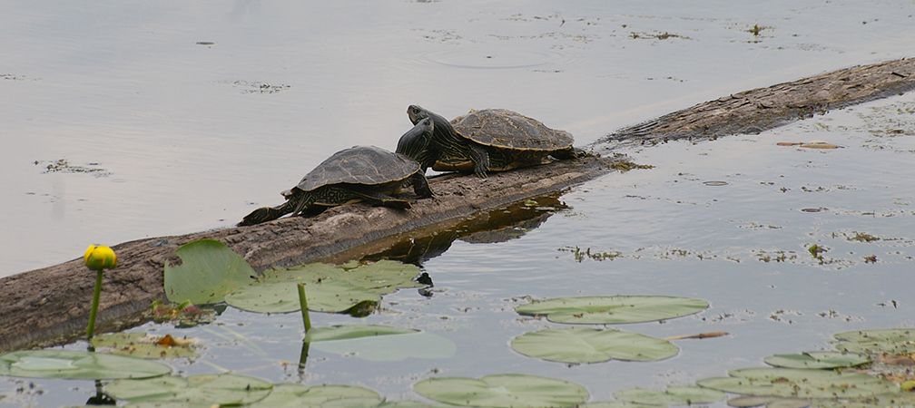
In 2022, Carleton University biologist, Grégory Bulté arrived at Opinicon Lake for his first day of field work for the season. Bulté has been studying and tracking northern map turtles since 2003, returning every spring to the lake.
As he went to retrieve his camera from the hibernation site, he spotted a dead turtle. He paddled towards it and then noticed another. Sightings of turtles with crushed shells and missing limbs continued. In his wetsuit, he swam the shoreline to pick up the carcasses, counting 142 in total —10 per cent of the total population.
This was the first time Bulté had witnessed a mass mortality like this. His research points to river otters accessing the hibernating turtles through holes in the ice.
It is uncertain how the holes in the ice formed. Climate change, human-made openings, and shifting ecosystems may be potential causes.
“We don’t have direct evidence that any cause led to this particular event. However, we thought it was important to publish this study, because what it did show, is that map turtles hibernate in such a way that it makes them vulnerable to fatality if something goes wrong,” said Bulté.
Ice protects turtles from predation. While there are no de-icing bubblers, which push bubbles into the water to stop it freezing around docks, next to the hibernation site at Opinicon Lake, Bulté has seen an increasing trend in their overall use.
“We are worried that without any regulation or knowledge of where map turtles spend their winters, we could decimate a population rapidly if these tools are put in close proximity,” said Bulté.
Since 2022, Bulté has not witnessed another mass mortality event. He is currently working alongside a statistician to analyze data from 2022 to 2026 to better understand how the population has been affected.
He believes that humans need to learn how to cohabitate better with wildlife.
“If we cannot keep them in their environment, what does that say about everything else we do to the environment?”
Ontario Nature’s Acting Conservation Science and Stewardship Director, Jenna Quinn emphasized that turtle species are at risk and cannot afford additional threats.
“It is important that we always move with nuance and understand that every action we take has a consequence,” said Quinn.
Work is being conducted to conserve the ecosystems that inhabit the turtles.
Ontario Nature’s Reptile and Amphibian Atlas (ORAA) is one tool that is currently being used to inform ongoing conservation work. It documents current knowledge of the distribution of reptiles and amphibians in the province, increasing public awareness and appreciation of these species.
Additionally, the Rideau Canal is a part of Preserving Legacies, a global organization dedicated to safeguarding heritage places and practices by advancing climate adaptation solutions that strengthen community resilience.
The canal is currently in its second phase of the project, which involves the creation of a comprehensive Risk Assessment that will be shared with the community.
Just over half the country is officially in drought, and about 155.7 million Americans—almost seven million more than last week—are now affected. The U.S. Drought Monitor’s April 23 report shows that 52.46% of the United States and Puerto Rico, and 62.78% of the Lower 48, are experiencing moderate drought or worse. According to NOAA, this is the worst spring drought on record for the continental United States.
This drought is not limited to one region. The Southeast just had its driest September-through-March since records began in 1895. The Colorado River system is only 36% full. Texas is 77% in drought, and Corpus Christi’s reservoirs have dropped to nearly 9%. Nebraska experienced its largest wildfire ever, fueled by dry grasslands. Oregon’s snowpack reached zero on April 1. In California, Tahoe City Cross melted completely by March 8, 40 days earlier than usual, after a record-breaking March heat wave caused rapid melting of an already low snowpack across most of the West.
The common factor is that from January through March, precipitation was below 70% of average across the lower 48 states, setting a new record. As a result, water restrictions are now broader and, in many places, more severe than usual.
The National Picture
The headline numbers come from the U.S. Drought Monitor, which is jointly produced by the National Drought Mitigation Center, USDA, and NOAA. As of April 21, drought conditions had worsened across the South, Southeast, Mid-Atlantic, High Plains, and West, with a 2.9% increase in coverage over the past week and an 11.7% increase over the past month. The Northeast and parts of Texas and the eastern Plains saw modest improvement; everywhere else trended drier.
Two main climate factors have caused this record drought. First, La Niña led to less rainfall from January to March, with totals below 70% of average—the lowest since records began in 1895, just surpassing the previous low in 1910. Second, spring temperatures in the Central Plains, Midwest, Northeast, and Mid-Atlantic were 5 to 10 degrees above normal, which sped up soil moisture loss and increased evaporation. This drought is not just about low rainfall; high temperatures are also drying out what little moisture remains.
The effects of the drought are already clear in the number of wildfires. By mid-April, over 1.7 million acres had burned across the country, nearly double the 10-year average. Nebraska’s Morrill Fire, which burned more than 640,000 acres in March, was the largest in the state’s history. In southeastern Georgia, the Highway 82 Fire destroyed at least 54 structures in Brantley County, which was the first county in the Southeast to reach exceptional drought (“D4”).
Southwest: The Colorado River Approaches a Threshold
The Colorado River Basin is facing water shortages not seen in modern times. The Bureau of Reclamation says the system is at about 36% of capacity. Lake Powell is only 23% full, and Lake Mead is about one-third full. Spring runoff into Lake Powell is expected to be just 22% of average. If this continues, 2026 could be one of the driest years in over sixty years, possibly even drier than 2002, which was the previous record.
In response, the Bureau of Reclamation announced in April that it plans to cut Lake Powell releases to 6 million acre-feet, the lowest in decades. They will also move water from Flaming Gorge to keep Lake Powell high enough for Glen Canyon Dam to generate hydropower. The dam provides electricity to about five million people, but water levels could drop too low by December if things do not improve. The seven states that share the Colorado River have not agreed on new rules for after 2026, when current guidelines expire. The Interior Department has said it may set new rules on its own if no agreement is reached this summer. Western states could be heading toward a conflict over water.
Local water restrictions are getting stricter. In March 2026, Erie, Colorado, moved to a Level 4 Emergency, the highest stage, which bans all residential sprinkler use. Aurora has completely banned new turf lawns. Denver Water started Stage 1 restrictions, asking residents to cut both indoor and outdoor water use by 20% until October 1. Along the Rio Grande, Elephant Butte is at 12.6% capacity, Falcon at 19.2%, and Amistad at 31.4%.
Source: UNLV Drought Monitor, April 28, 2026.
California: Permanent Rules Meet a Fourth Dry Year
California’s situation is more complex than just being in drought or not. In January 2026, the Drought Monitor showed no part of California in drought for the first time in 25 years. By April, Southern California was facing its fourth straight year of below-average rainfall. The statewide snowpack was only 18% of normal, and the State Water Project will limit water releases to 30% of normal.
What’s notable is that California’s restrictions no longer depend on whether a drought is officially declared. After the 2012-2017 drought, the state moved to a permanent year-round conservation framework codified by state law AB 1572 and the State Water Resources Control Board’s “Making Conservation a California Way of Life” rules.
Statewide baseline rules apply every year, regardless of conditions: no hosing down driveways or hardscape; no irrigation within 48 hours of rainfall; no irrigation runoff into streets or storm drains; mandatory shutoff nozzles on hoses; and recirculation requirements for fountains and decorative water features.
On top of these restrictions, the Metropolitan Water District of Southern California, which serves 19 million people, issued a Level 1 conservation notice in March 2026 to all 26 city and county agency members. State enforcement of the new water-budget rules is paused until 2027 to give utilities time to adjust.
California is in for a dry summer this year.
Southeast: A Recharge Season That Failed
The Southeast, usually a humid region, is now facing a record drought. Georgia, North Carolina, and South Carolina all had their driest September-through-March since 1895. Normally, the region relies on December through March to restore soil moisture, streamflows, and groundwater, but this year, that recharge mostly did not occur.
The result, as of April: 100% of North Carolina, 99.95% of Virginia, 99.34% of South Carolina, 98.99% of Florida, 98.13% of Georgia, 93.65% of Tennessee, and 88.66% of Alabama are in drought. In Georgia, extreme drought now covers 71% of the state, the highest reading since 2012. Some monitoring stations with 75 or more years of data are recording their driest six-month periods on record. Drought watches are active across Virginia, Tennessee, and Alabama, with mandatory rules likely if late-spring rainfall doesn’t materialize.
Texas and the Southern Plains: Cities at the Edge
Texas is 77% in drought as of mid-April. The Coastal Bend story is the one to watch closely. Combined storage at Choke Canyon Reservoir and Lake Corpus Christi has fallen to 8.7% as of April 2026 — among the lowest levels ever recorded. Corpus Christi has been under Stage 3 mandatory restrictions since December 2024, the most severe stage in the city’s standard drought contingency plan, which is triggered when combined reservoir storage drops below 20% capacity. Stage 3 bans all outdoor irrigation, home vehicle washing, and most non-essential outdoor water use; second and subsequent violations carry fines up to $2,000 each.
The bigger concern is what happens next. City models now predict a Level 1 Water Emergency by September 2026, when the water supply could be just 180 days from running out. On April 28, 2026, the City Council postponed a vote on a proposal that would require everyone—residents, businesses, and industry—to cut water use by 25% if Level 1 is declared. Many residents at the meeting said this cut would be impossible unless industrial users reduce even more.
If Corpus Christi runs out of water—a scenario city officials now consider possible—it would be the first modern American city to face this. There is no guidebook for what to do. In the worst case, the city could see rolling water shutoffs by district, water delivered by tanker trucks, and even managed evacuations. The largest industrial users, such as petrochemical refineries, would likely lose access to water first, potentially leading to lawsuits.
In other parts of Texas, Dallas has had a permanent rule since 2001 that only allows watering lawns two days a week, and no irrigation is allowed between 10 a.m. and 6 p.m. from April to October. In Oklahoma and Kansas, the Ranger Road Fire—the largest U.S. wildfire of 2026 so far—burned 283,283 acres in February, killed hundreds of livestock, and led to burn bans across central and eastern Oklahoma.
High Plains: Dust, Fire, and Lake Beds
Nebraska is experiencing conditions that one state climatologist said are unlike anything seen before. Fifty-six percent of the state is in extreme drought, similar to 2012 but with warmer temperatures. The Morrill Fire started in March and quickly spread through dry grasslands, burning over 640,000 acres—the largest wildfire in Nebraska’s history. In Sheridan County, some landowners say their private lakes have dried up completely for the first time since 2012.
The Black Hills in South Dakota are now in extreme drought. In southern Nebraska, southwest Kansas, and southeast Colorado, low rainfall combined with high temperatures and evaporation have made spring planting difficult in many areas. The U.S. Geological Survey reports that streamflows are below or much below normal across southwestern South Dakota, southern Nebraska, and central and western Kansas.
Mandatory urban restrictions in this region are still relatively rare, but burn bans are widespread, and ranchers are culling cattle herds rather than feeding them on pastures with no grass.
Pacific Northwest: A Snow Drought, Not a Rain Drought
The Pacific Northwest had more precipitation this winter than the Southwest, but most of it fell as rain instead of snow because of record-warm temperatures. This has caused a snow drought rather than a rain drought. Since the region relies on snowpack for summer water, this is a serious problem.
Across the broader Columbia River Basin, snowpack ranks in the second percentile. On April 8, Washington’s Department of Ecology declared a statewide Drought Emergency, citing snowpack at just 53% of the median and projected summer water supply below 75% of normal in many basins, including the Yakima. Junior water-rights holders in the Yakima Basin are projected to receive only 44% of their allotment. Idaho is facing what could be its fourth consecutive drought year in its northern basins.
For the Northwest, the effects go beyond just this summer. New research from Oregon State University predicts that by the end of the century, water will move from precipitation to streamflow about 18% faster on average. This happens because there is less snow and more rain, so water moves through the system more quickly instead of slowly melting from snowpack. As a result, there could be about 50% less water in rivers, lakes, and reservoirs during the summer growing season.
The shift toward earlier runoff seen in 2026 is not a one-time event. It is a preview of the more severe impacts that climate change could bring.
Where Restrictions Are Active
This is a partial snapshot as of April 27, 2026. Local utilities update stages weekly. Verify before relying on these figures.
Region
Location
Stage / Action
Notes
Southwest
Erie, CO
Level 4 Emergency
All residential sprinklers banned; most severe Front Range stage
Southwest
Aurora, CO
Stage 1 + turf ban
New turf lawn installations prohibited
Southwest
Denver, CO
Stage 1 (through Oct. 1)
Watering schedule by address
California
MWD Southern Calif. region
Level 1 conservation notice
Issued March 2026; covers 19M residents
California
San Francisco (SFPUC)
Level 2
Tied to Hetch Hetchy levels
California
Sacramento
Stage 2
Folsom Lake at 48%
Southeast
SW Florida (SWFWMD)
Phase III (Apr 3 – Jul 1)
Possible extension if summer rains fail
Southeast
Raleigh, NC
Mandatory Stage 1 (from Apr 20)
Odd/even address watering schedule
Southeast
Valdosta, GA
Mandatory 1-day/week (from Apr 15)
First Georgia city to move to mandatory rules
Texas
Corpus Christi
Stage 3 — Reservoir Crisis
Reservoirs at 8.7%; 25% cut planned for September
Texas
Dallas
Permanent 2-day/week
Ordinance since 2001; no irrigation 10am–6pm Apr–Oct
Pacific NW
Washington (statewide)
Drought Emergency (Apr 8)
Snowpack at 53% of median; Yakima Basin junior rights cut to 44%
Pacific NW
Oregon (snow drought)
No statewide order yet
Snow water equivalent at zero percentile on April 1
What You Can Do
Households use about 10% of all water in the U.S. Agriculture is still the biggest user, but in cities with restrictions, saving water at home can help prevent stricter rules, fines, or limits on businesses. The EPA’s WaterSense program says the average American family uses about 300 gallons a day, and simple upgrades can cut indoor use by 35%.
Indoor (immediate, no cost):
Check your home for leaks. On average, American homes waste over 11,000 gallons a year from running toilets and dripping faucets. A single toilet leak can waste 200 gallons a day. To test for leaks, put food coloring in the tank—if it shows up in the bowl without flushing, you have a leak.
Turn off the tap while brushing your teeth or shaving. This can save 8 to 10 gallons per person each day.
Only run your dishwasher and washing machine when they are full. You can also skip pre-rinsing dishes.
Take shorter showers. Reducing your shower by two minutes with a standard showerhead can save about 5 gallons of water.
Indoor (small investment):
Install WaterSense-labeled fixtures. Faucet aerators and showerheads use at least 20% less water and are inexpensive. The average family can save about 3,500 gallons of water and 410 kWh of energy each year just by using these.
Replace any toilet made before 1992. Older toilets use 4 gallons per flush, while WaterSense models use 1.28 gallons or less.
Outdoor (where most savings can happen):
Outdoor irrigation uses nearly 9 billion gallons of water a day nationwide. It makes up about 30% of household water use, and up to 70% in dry areas. Water your yard before sunrise or after sunset to reduce evaporation.
Consider replacing your lawn with drought-tolerant plants that are suited to your region. This type of landscaping uses less than half the water of a traditional lawn. Many cities, such as Aurora, Las Vegas, and Phoenix, offer rebates for replacing turf.
Install a smart irrigation controller with a rain shutoff or soil moisture sensor. These devices adjust watering based on real conditions instead of following a set schedule.
Add 2 to 3 inches of wood chips as mulch to your flower beds and vegetable gardens. This helps reduce evaporation and keeps weeds down.
Community and policy:
Find out your utility’s current drought stage and the rules that apply. Most utilities post this information online and let you report water waste, like irrigation during banned hours or broken sprinklers spraying onto pavement.
If you’re in an HOA, know your rights. California’s AB 1572 and Texas Property Code §202.007 prohibit HOAs from fining residents for brown lawns during active water restrictions. Other states are following this example.
Pay attention to how agriculture and industry use water in your area. While homes use only about 10% of water, decisions about the other 90%—used by farms and businesses—will shape whether household conservation efforts make a lasting difference.
The Big Climate Picture
Some may see the 2026 drought as just a mix of La Niña, a warm winter, and early snowmelt, with rain expected to return as conditions change and an El Niño watch begins for late summer. While this is partly true, the bigger pattern—record warmth, snow falling as rain, earlier and faster runoff, and reservoirs unable to keep up as demand rises during hotter, longer summers—is what climate science has predicted for nearly twenty years.
Lake Powell is at 23%. Oregon’s snowpack is gone. North Carolina is completely in drought. Corpus Christi is preparing for the chance of running out of water. These are not separate stories. They are all part of the same story, showing what aridification looks like when it becomes a daily reality instead of just a forecast.
Editor’s note: Drought conditions are evolving weekly. Statistics in this piece are current as of the U.S. Drought Monitor release dated April 21–23, 2026. Local water restrictions change frequently — verify with your utility before relying on the figures cited here.
Divers working to dismantle and remove discarded fishing nets in the Mediterranean Sea had an incredible and historic close encounter with a great white shark (Carcharodon carcharias). It is believed to be the first time a great white shark has been caught on film underwater in the Mediterranean.
Ask E. Jean by Ivy Meeropol is holding over for second week at IFC Center in New York after a full-house opening weekend and adding the NuArt in LA before expanding. Over 40 theaters are booked for the next month as the distributors build a network to support the documentary about the writer and former […]
The City of Calgary has a plan to reduce the water loss rate to 15 per cent by 2030, but it comes with a cost of $342 million over the next four years.
Jan Erik Waider has a knack for capturing shorelines, volcanic eruptions, and glaciers at their most mesmerizing—shrouded in mist, glowing in the darkness, or illuminated by pale northern light. His atmospheric photographs of icy seas and rugged landscapes from Iceland to the Antarctic, focus on dramatic forms and cast remote places into a dreamy ethereality.
Most recently, Waider captured a striking phenomenon in the Baltic Sea, just off the coast of northern Germany. Fresh ice formed a thin layer on the rolling surface, creating faceted, polygon-like shapes that moved gently and rhythmically with the waves without breaking apart.
Waider’s aerial drone perspective creates an otherworldly, almost totally abstract effect. At first glance, it appears as though it could be a minimalist animation highlighting the interactions between water, light, and motion. “Soft evening light, fine crack lines, and shifting tones from warm gold to deep green turned this fleeting moment into a study of structure, depth, and calm,” Waider says.