NASA Administrator Jared Isaacman on Wednesday defended the decision to use an all-male crew for the approaching Artemis III mission. “I have seen reactions ranging from disappointment to outrage,” Isaacman wrote in a post on X, in response to complaints about the mission lacking female astronauts. “I have personally been to space twice with 50...
Blue Origin's New Glenn rocket exploded on the launchpad during a test in Cape Canaveral on Thursday. The company, owned by Jeff Bezos, said no one was injured and all personnel were accounted for. But the rocket has a crucial role in NASA's Artemis program to return American astronauts to the surface of the moon. Amna Nawaz discussed its significance with science correspondent Miles O'Brien.
NEW YORK, June 8 — Italian fashion house Prada unveiled on Sunday the inner-layer garment set to be worn by Nasa astronauts heading to the moon, underscoring the brand’s push to be the first major luxury player to make inroads in the space industry.
The body-hugging suit, created in collaboration with Houston-based space infrastructure developer Axiom Space, features ventilation tubes knitted into the garment.
“We have really a broad spectrum of capability and know-how,” Lorenzo Bertelli, Prada’s chief marketing officer, said at an event at Prada’s Manhattan store, sitting beside a mannequin donning the new Liquid Cooling and Ventilation Garment.
Expertise for developing space exploration products “can come from lots of seemingly unrelated industries,” said Jonathan Cirtain, CEO of Axiom Space.
The new product follows Prada’s splashy foray into space fashion in 2024 with the unveiling of a spacesuit that is expected to be used for Nasa’s anticipated Artemis 4 moon landing in 2028.
Luxury brands have long drawn inspiration from space travel. But Prada has gone “beyond inspiration into an actual partnership” as the space exploration and tourism industries develop, said Thomai Serdari, a luxury brand strategist and marketing professor at New York University’s Stern School of Business.
Serdari pointed to two factors motivating Prada’s interest in the space industry: to gain access to affluent consumers who are contemplating space travel, and to align the brand with avant-garde thought. Companies from Jeff Bezos’ Blue Origin to Elon Musk’s SpaceX have leaned into space tourism for the wealthy.
The resumption of space exploration and human travel to the moon is “bound to attract a lot of eyeballs,” said Luca Solca, global head of luxury goods at Bernstein. Luxury brands need to stay relevant and visible, he said.
Prada’s push comes against a backdrop of a struggling luxury goods sector. After two years of contraction, the industry was showing signs of stabilization until the Iran war began at the end of February, disrupting travel and denting luxury spending far beyond the Middle East.
Will luxury peers follow?
Other fashion and apparel companies have jumped on the space bandwagon. Under Armour has partnered with spaceflight company Virgin Galactic to create space apparel, while Columbia Sportswear has worked with space exploration company Intuitive Machines on space fabric technology.
But it remains unclear whether other luxury players might follow Prada’s lead.
“In luxury, it is important to be the first to do something, to be a trend-setter,” Serdari said, noting that LVMH’s Louis Vuitton, Hermès and Chanel are all interested in space travel but that they would likely find new ways to make inroads.
“You will never see the upper crust of the luxury sector copying each other,” she added. — Reuters
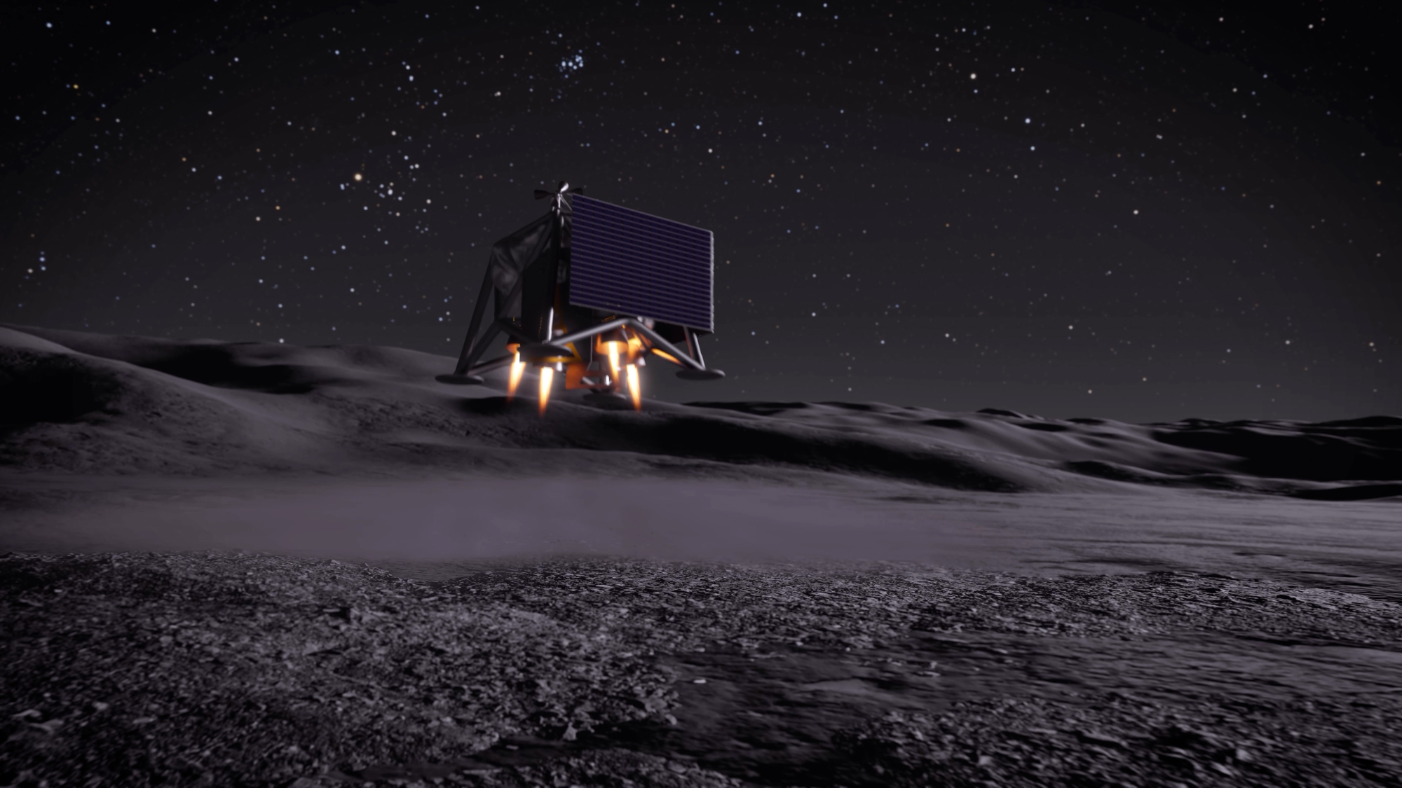
As NASA looks ahead towards Artemis III in mid-2027, the agency is sharing new details on several projects, including a future permanent moon base and a drone mission called MoonFall. The mission will send four drones to survey the surface of the moon’s South Pole to spot potential landing sites for future Artemis astronauts.
According to the update, the Jet Propulsion Laboratory (JPL) in Southern California has been developing the drone design and testing prototype hardware ahead of the scheduled 2028 launch. Each drone will land on the moon’s surface and gather high-resolution imagery of the terrain over the course of a single lunar day (up to 14 Earth days). After each drone’s last flight, its survive-the-night payload will continue to work for several months. Payloads that are designed to survive-the-night can endure the sub-zero temperatures of the lunar night, which can get as cold as -208 degrees Fahrenheit.
Each of the four drones should weigh about 550 pounds, and stand at four-feet tall and seven feet in diameter. They will use a Lunar Dashcam imaging system to create maps of the terrain. The drones will also be equipped with a laser retroflector array so that mission control can precisely locate the drones, a neutron spectrometer system to help determine how much (if any) subsurface water is present, and a spectrometer to measure radiation.
Texas-based Firefly Aerospace was selected to build the spacecraft that will transport the drones. Firefly’s Elytra spacecraft will carry the drones for a 45-day transit from the Earth to the moon. After entering lunar orbit, it will deorbit and perform a braking maneuver to send out the drones roughly 31 miles above the lunar South Pole.
No stranger to lunar exploration, Firefly Aerospace’s Blue Ghost lander became the first commercially built lander to reach the lunar surface in March 2025. While on the moon, Blue Ghost delivered 10 NASA instruments designed to gather lunar subsurface data and also snapped some beautiful images of a solar eclipse.
As of now, NASA and 66 other nations have signed the Artemis Accords. While not an international treaty, the Artemis Accords is an agreement for high-level principles of space exploration and provides a basic legal framework for exploring and developing the lunar surface during this century. However, the NASA-led Artemis group is in direct competition with an initiative led by China to explore the lunar South Pole and potentially extract its resources.
As climate change increases the frequency and intensity of flooding, it’s becoming increasingly important to monitor and predict flood hazards at different scales. A new article in Reviews of Geophysics presents a data-driven performance analysis of various space-based sensors that monitor flood hazards. Here, we asked the lead author to give an overview of satellite-based flood monitoring, the benefits and challenges of using satellite-based sensors, and future space-based projects.
Why is it important to monitor the surface waters on Earth?
More than half of the world’s population lives within three kilometers of a freshwater body. When seasonal flooding behaves as anticipated, it provides essential nutrient replenishment to soils and crops. However, extreme flooding disturbs the careful balance of freshwater systems and can cause damaging flooding that disrupts livelihoods.
Climate change is making these extremes more frequent and less predictable, while expanding populations in flood-prone areas amplify the human cost. Continuous monitoring of Earth’s surface waters is essential as it helps us anticipate hazards, evaluate risk, and design interventions that protect the people and places most exposed to hydrologic hazards.
What are the benefits of monitoring flood inundation from space compared to other techniques?
Monitoring flood inundation from space is advantageous due to the wide-scale global coverage that captures important information over large areas. In-situ sensors, such as river gauges, provide valuable data but are limited in spatial coverage and may even fail under significant flood conditions. A single satellite overpass can potentially capture an entire river basin, allowing responders to see where water has spread, which communities are affected, and how the event is evolving.
When did scientists first start using satellites to monitor surface waters?
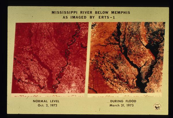
The value of monitoring surface water from space was first realized in the early 1970s, following the launch of Landsat 1. Soon after launch, it captured imagery of the devastating 1973 Mississippi River floods, producing one of the first flood maps made from space (Figure 1). By the early 2000s, NASA’s MODIS sensors were providing global coverage at a daily frequency. Today, multiple global flood monitoring systems are in place, including the European Union’s Copernicus Emergency Management Service, which maps floods using Sentinel-1 synthetic aperture radar (SAR), and NOAA’s VIIRS Flood Mapping system.
Figure 1. Imagery from the start of the Landsat 1 mission illustrating the extent of the Mississippi River flooding of 1973 (EROS History Project). The Earth Resources Technology Satellite 1 (ERTS-1) was renamed Landsat 1 in 1975. Credit: USGS
What are the three types of satellite-based sensors that your review focuses on?
Our review examines three families. Multispectral (optical and thermal) sensors capture reflected sunlight or emitted heat. Microwave sensors, including SAR, passive microwave radiometers, and GNSS Reflectometry (GNSS-R), can observe through clouds and at night but involve trade-offs between resolution and coverage. Finally, altimetric sensors measure water surface elevation with high precision but only along narrow tracks. Each family has distinct strengths and weaknesses that lend themselves to use in combination for comprehensive flood inundation monitoring.
What are some of the challenges of using satellite-based sensors to monitor flooding?
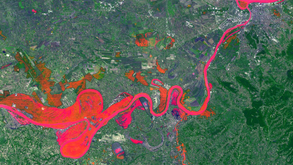
The fundamental problem is that floods and satellite observations are mismatched in time and space. Optical sensors often capture clouds rather than the floodwater beneath. Cloud-penetrating sensors like SAR can miss flood peaks if their orbital schedule doesn’t align with the event, and dense vegetation can obstruct floodwater from both optical and shorter-wavelength radar. Sensors with high temporal resolution typically deliver data at coarse spatial resolutions, sometimes tens of kilometers per pixel. These trade-offs form what we describe as the “iron triangle” of Earth observation: temporal resolution, spatial resolution, and cost. A sensor can typically be optimized for two, but rarely all three. Occasionally, the timing and conditions of a flood align well with sensors whose strengths are complementary across the iron triangle, yielding the kind of multi-sensor view shown in Figure 2.
Figure 2. Sentinel‐2 MSI True Color Image with Sentinel‐1 SAR derived flood‐extent superimposed on top. The top right circle highlights the missing SAR‐derived information, whereas the bottom circle highlights the missing optical information. Credit: Campo et al. [2026], Figure 5
What are some upcoming space-based sensor projects that could advance the field of hydrology?
Several are already reshaping the field. NISAR, a joint NASA–ISRO radar satellite launched in 2025, carries an L-band sensor designed to penetrate vegetation canopy, providing new insights into flooding beneath vegetation. Sentinel-1D, launched in late 2025, has restored the Sentinel-1 constellation to full two-satellite capacity, halving the revisit time. Landsat Next, a planned three-satellite constellation with 26 spectral bands and a six-day revisit, would provide valuable hydrologic data at both high temporal and spectral resolutions. However, recent budget pressures have introduced uncertainty about its final scope. Finally, the HydroGNSS mission from ESA will use GNSS-R to monitor hydrologically linked Essential Climate Variables.
Editor’s Note: It is the policy of AGU Publications to invite the authors of articles published in Reviews of Geophysics to write a summary for Eos Editors’ Vox.
Citation: Campo, C. (2026), Can any single satellite keep up with the world’s floods?, Eos, 107, https://doi.org/10.1029/2026EO265016. Published on 20 April 2026.
This article does not represent the opinion of AGU, Eos, or any of its affiliates. It is solely the opinion of the author(s).
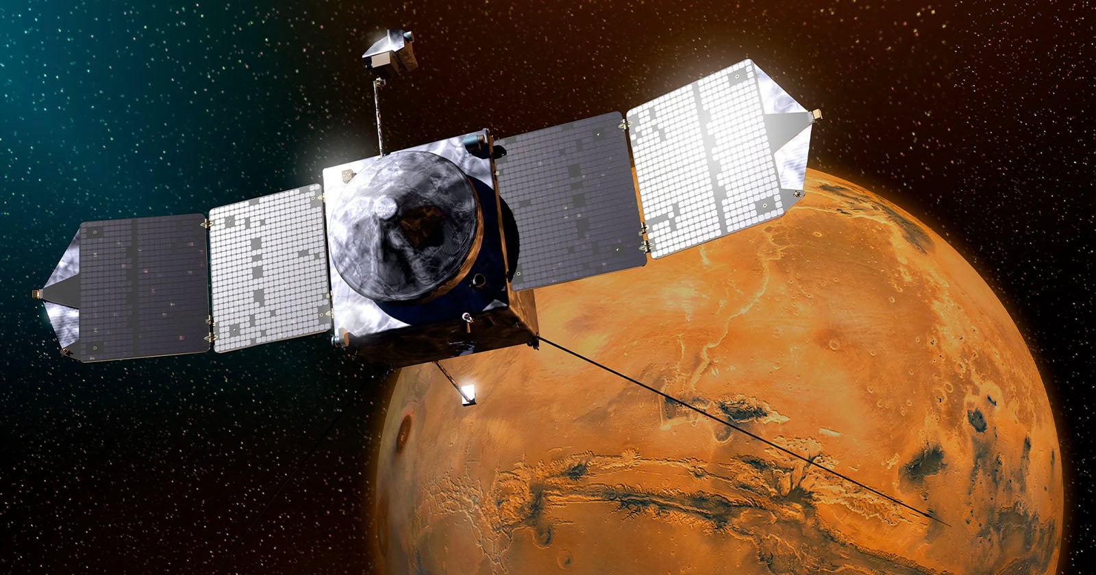
This is a depiction of mars, based on a public domain 2003 photo by NASA <i>(incidentally the black background is separate from mars and can be removed if you want a transparent mars by itself)</i>
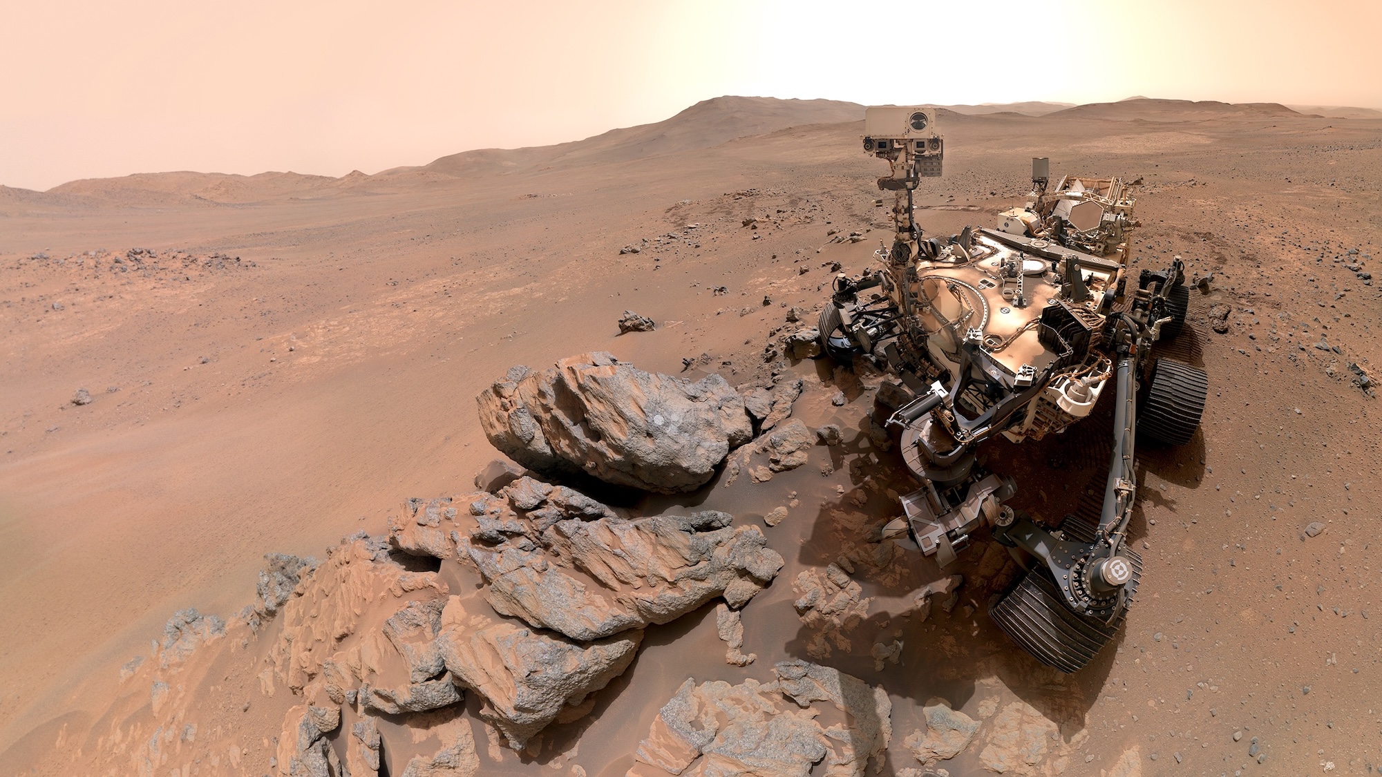
After five years of rolling across Mars, NASA’s Perseverance rover is still going strong. And it has the selfies to prove it. NASA highlighted its “six-wheeled scientist’s” latest Red Planet excursion in a mission update on May 12, explaining that the explorer is currently engaged in the Northern Rim Campaign. This is Perseverance’s fifth project since arriving on Earth’s planetary neighbor in February 2021. Compiled from 61 separate photos taken in March, the latest scene depicts Perseverance near a region known as Lac de Charmes.
“We took this image when the rover was in the ‘Wild West’ beyond the Jezero Crater rim—the farthest west we have been since we landed at Jezero a little over five years ago,” Perseverance project scientist Katie Stack Morgan said in a statement.
Prior to snapping its selfie, the rover had just finished abrading the rocky Arethusa outcrop. This task involves using the drill on its robotic arm to grind a section of the geological formation, which then offers scientists back on Earth the materials necessary to analyze its composition. After remotely examining the rock’s chemistry, researchers learned Arethusa is largely igneous minerals dating even further back than the Jezero Crater itself. The outcrop likely formed underground millions of years ago from molten material.
The latest portrait is the sixth selfie taken by Perseverance since arriving on Mars. To pull it off, the rover relied on its Wide Angle Topographic Sensor for Operations and eNgineering (WATSON) camera installed at the end of its robotic arm. It took about one hour to accomplish and required 62 extremely fine-tuned movements to ensure the clearest shot possible.
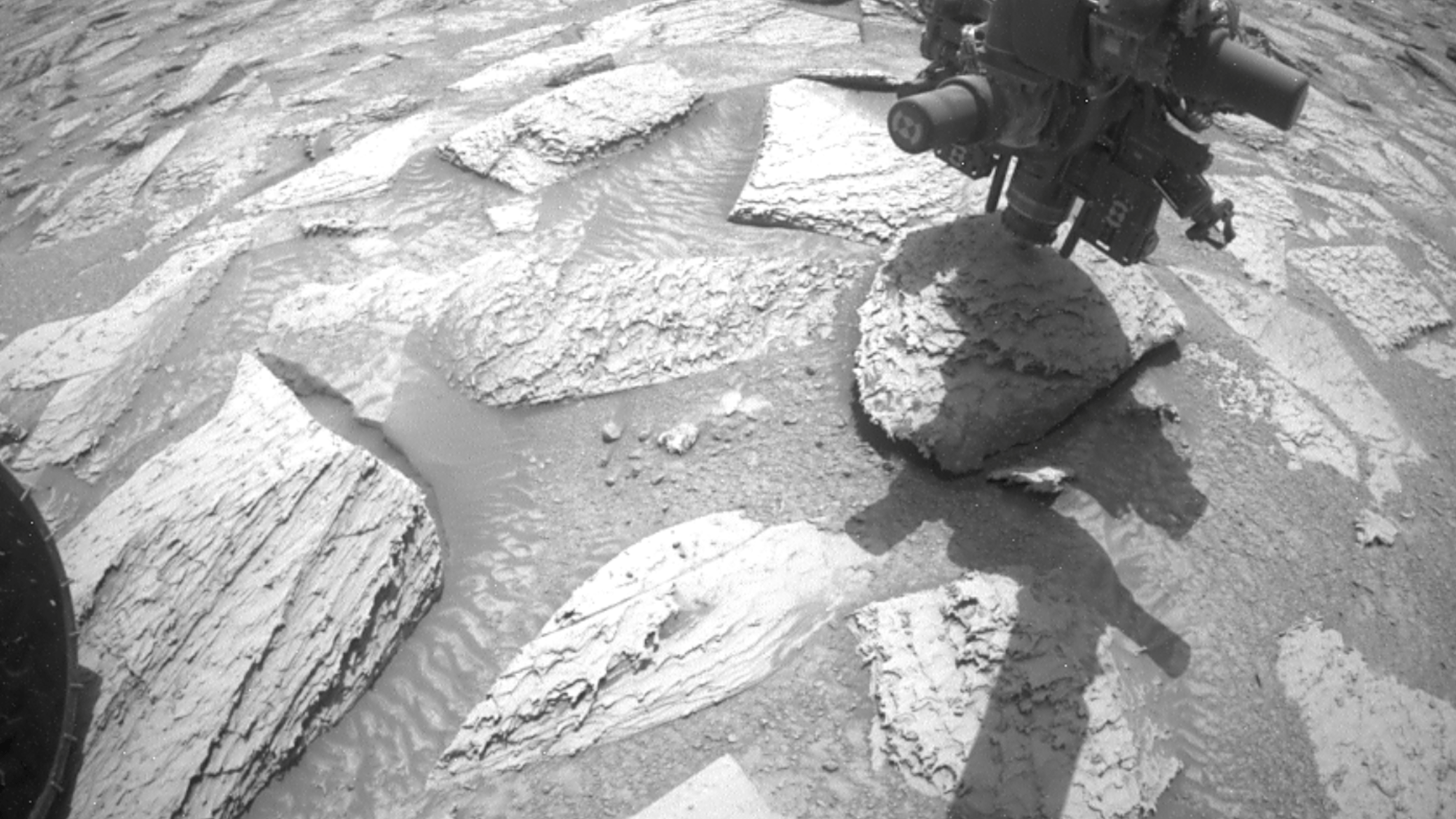
NASA’s Perseverance captured this enhanced-color panorama of an area nicknamed “Arbot” on April 5, the 1,882nd Martian day, or sol, of the mission. Made of 46 images, the panorama offers one of the richest geological vistas of the rover’s mission, revealing a windswept landscape of diverse rock textures. Credit: NASA / JPL-Caltech / ASU / MSSS
Lest anyone think Perseverance is too narcissistic, the rover also employed its Mastcam-Z to also photograph Lac de Charmes’ Arbot area a few days later. The vista scene is the result of 46 combined images, and will help NASA plot out a route to further investigate the ridge. Thanks to the new vantage points, scientists already think they have spotted a few megabreccia—massive chunks of rock as big as skyscrapers that were launched during a meteorite impact about 3.9 billion years ago.
“The rover’s study of these really ancient rocks is a whole new ballgame,” Stack Morgan explained. “These rocks—especially if they’re from deep in the crust—could give us insights applicable to the entire planet, like whether there was a magma ocean on Mars and what initial conditions eventually made it a habitable planet.”
While a holiday weekend has come and gone, May 26 is not without a cause for celebration. It’s National Paper Airplane Day!
The annual day commemorates the homemade aeronautical toy that has fascinated (and frustrated the less crafty) children and adults for generations. According to National Day, the practice of constructing paper planes is sometimes called aerogami, after origami, the Japanese art of folding paper. Building paper planes that can soar through the air like a bird is believed to have originated in ancient China, where paper was invented around 105 CE. However, the art of folding it into an airplane may have been perfected in Japan, as it is similar to origami.
Here in the United States, instructions for folding the Basic Dart were included in a children’s book published in 1859, so it is safe to say kids and adults alike have been making them for over 167 years. The term paper airplane was then coined in 1907 and replaced paper dart as the dominant term by the 1950s. In 2022, Kim Kyu Tae nabbed the Guinness World Record for the Longest Paper Airplane Throw Ever with a flight of 252.6 feet. According to Guiness World Records, the longest time flying a paper aircraft is 31.2 seconds and was achieved by Rao Chongyi and a team in China in February.
If you’re inspired to create the world’s best paper airplane, we have you covered. You can also look to the great minds at NASA for inspiration. After all, the first letter “A” in NASA stands for aeronautics. Their step-by-step NASA Space Crafts tutorial will not only help you make a colorful paper airplane, but also NASA’s X-57 Maxwell and the X-59 Quiet SuperSonic Technology.
May your National Paper Airplane Day be free of paper cuts.
Curiosity got itself stuck between a rock and hard place last month, but NASA says there’s no reason to fret about the intrepid Mars rover. On April 25, mission engineers were remotely piloting its robotic arm’s rotary-percussive drill into a Martian rock nicknamed Atacama. It’s a relatively routine task for Curiosity, which takes the samples and then pulverizes them into a powder for future onboard chemical analysis.
But Atacama is no small stone. The hefty, 1.5-foot-wide geologic formation is about six inches thick and weighs about 28.6 pounds. So NASA engineers were understandably a bit worried when Curiosity attempted to retract its arm—and subsequently lifted the entire rock off the ground.
“Drilling has fractured or separated the upper layers of rocks in the past, but a rock has never remained attached to the drill sleeve,” the agency explained in a recent rundown.
While amusing to envision, the situation was no laughing matter for NASA’s engineers. The rover’s drill would be of little more use with a giant rock indefinitely attached to it. But even if controllers could detach Atacama from the rover, the force might damage the tool or the arm itself. Without those capabilities, Curiosity’s ongoing mission would be in serious jeopardy.
Mission specialists first tried the drilling version of “turning it off and on again,” by vibrating the tool. However, Atacama remained stubbornly stuck on Curiosity…for another four days. NASA then tried a new approach by reorienting the robotic arm and instructing the drill to vibrate one more time. Atacama managed to shake off a bit of sand that time, but little else.
Two more stressful days passed before NASA gave it a third try. Engineers tilted the drill slightly further, then rotated and vibrated the tool while also spinning its drill bit. The Curiosity team anticipated it may take multiple attempts to pull off the feat.But in this case, Atacama finally gave way almost immediately. The nearly weeklong ordeal culminated with the giant rock fracturing as it landed on the Martian ground.
So far, NASA hasn’t reported any lingering damage to the vehicle, meaning the rover is likely ready to continue exploring the Red Planet. As for Atacama, it seems the Martian rock learned a valuable lesson: Don’t mess with Curiosity.
When it comes to photo dumps, NASA has upped the ante. The organization has added thousands of snapshots from the Artemis II mission to the Gateway to Astronaut Photography of Earth archive. The album now holds 12,217 images by cosmic travelers Reid Wiseman, Victor Glover, Christina Koch, and Jeremy Hansen during their more than 250,000-mile, 10-day flyby mission around the moon.
According to PetaPixel, a couple of Nikons and an iPhone 17 were the cameras of choice for the journey. And even though many of the thousands of recently uploaded images are very similar—some are even quite blurry—scrolling through them gives the impression of being seated right next to the “Moonfarers” as they marvel at Earth and its satellite and simply can’t put the camera down—just like we tend to snap way too many photos of a beautiful sunset.
Some of the most impactful photos include the reflections of the astronauts’ hands and faces in the window of their vehicle, the Orion module. Juxtaposed with meticulously engineered equipment, the earth and moon seem somehow less abstracted from this unique vantage point, in which these orbs appear somehow more resonant and precious—and vulnerable.
Explore more of our favorites below, and learn about the Artemis II mission on NASA’s site.