Editors’ Highlights are summaries of recent papers by AGU’s journal editors.
Source: Journal of Geophysical Research: Solid Earth
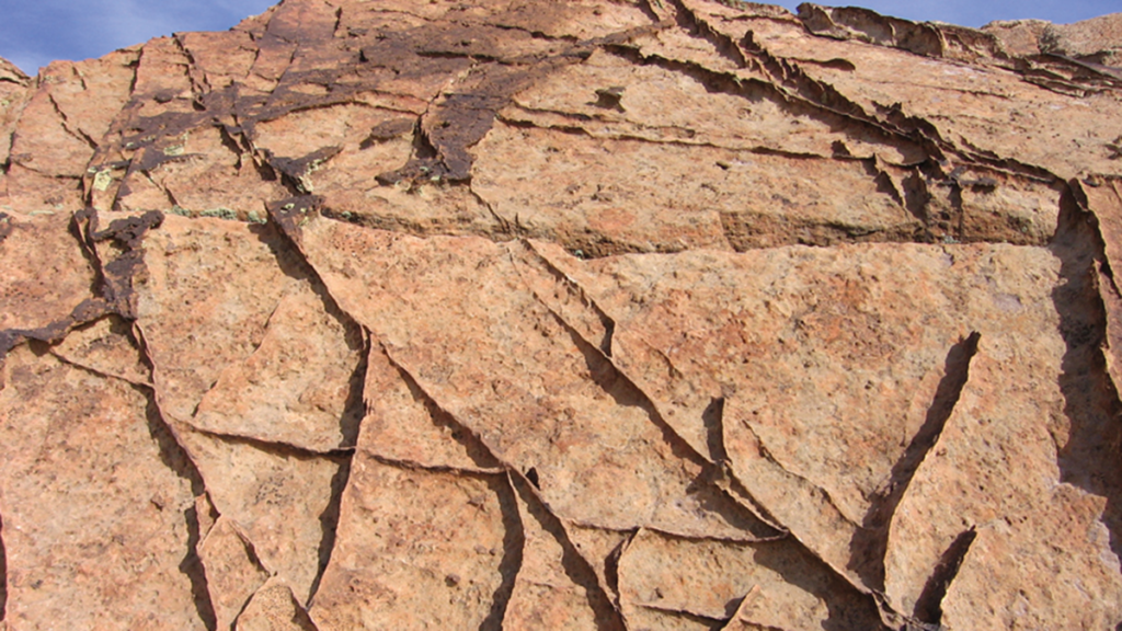
Highly porous rocks, such as sandstones, often deform in a surprising way: instead of breaking apart or sliding, they develop thin zones called deformation bands. In these bands, the grains are squeezed closer together, making the rock denser, and reducing how easily fluids such as water or oil can move through it. This behavior is important because it affects
Source: Journal of Geophysical Research: Solid Earth
Highly porous rocks, such as sandstones, often deform in a surprising way: instead of breaking apart or sliding, they develop thin zones called deformation bands. In these bands, the grains are squeezed closer together, making the rock denser, and reducing how easily fluids such as water or oil can move through it. This behavior is important because it affects both the strength of rocks and their ability to store and transport fluids underground. However, these bands are difficult to model because they form suddenly from an initially uniform material and concentrate deformation into very narrow zones.
Wang et al. [2026] developed a computer modeling approach called a “phase‑field model” to study this process. Instead of drawing the bands in the initially homogeneous rock, the model allows them to appear naturally as the system evolves and minimizes its energy. The study shows how grain crushing and rearrangement allows the formation of localized deformation zones. The results also demonstrate that natural spatial variations in the rock, such as differences in grain size or porosity, strongly influence where bands initiate and how they grow. Additionally, the model captures how deformation changes from sliding (shear bands) to pure compaction as pressure increases. Overall, this work provides a realistic way to understand how localized deformation develops in rocks, with important implications for geology, engineering, and energy applications.
Citation: Wang, Y., Zhang, C., Braun, P., Kang, X., & Wu, W. (2026). How does heterogeneity control strain localization patterns in high-porosity rocks? Journal of Geophysical Research: Solid Earth, 131, e2025JB032494. https://doi.org/10.1029/2025JB032494
By Steven Trask
Australia on Monday ordered a string of China-linked shareholders to sell their stakes in a rare earths firm, citing the need to protect the sector from outside influences.
Northern Minerals is vying to challenge China’s dominance of dysprosium production, a rare earth mineral that is used to make high-performance magnets used in electric vehicles.
Australian Treasurer Jim Chalmers. File photo: Australia’s Treasury.
Chinese investors have in recent years sought to ta
Australia on Monday ordered a string of China-linked shareholders to sell their stakes in a rare earths firm, citing the need to protect the sector from outside influences.
Northern Minerals is vying to challenge China’s dominance of dysprosium production, a rare earth mineral that is used to make high-performance magnets used in electric vehicles.
Australian Treasurer Jim Chalmers. File photo: Australia’s Treasury.
Chinese investors have in recent years sought to take sizeable positions in the Australia-based firm, and Canberra had already used the same rules to remove another batch of China-linked shareholders in 2024.
Wary of a takeover by stealth, the company referred itself to Australia’s foreign investment review board in November 2025. The government has kept a close eye on it since then.
Treasurer Jim Chalmers said six shareholders would be forced to exit Northern Minerals.
“We operate a robust and non-discriminatory foreign investment framework and will take further action if required to protect our national interest in relation to this matter,” he said in a statement.
Three of those shareholders had addresses listed in China, two were listed in Hong Kong, and one was listed in the British Virgin Islands.
The list included some of Northern Minerals’ largest single shareholders, including Beijing-based Vastness Investment Group, which held more than six percent of the firm.
Vastness tried to use its sizeable stake to replace the chair of Northern Minerals earlier this year.
It eventually withdrew its bid to vote on the company’s leadership at an extraordinary general meeting.
Hong Kong-based Qogir Trading and Service Company separately holds almost five percent of Northern Minerals.
Australia has over the past two years waged a running battle to pry Northern Minerals away from Chinese investors.
It used the same foreign takeover laws in 2024 to force a different group of Chinese investors to sell shares in Northern Minerals.
Northern Minerals said it was “currently considering the new disposal orders and will make a further announcement once it has done so”.
The United States signed a deal in October last year unlocking greater access to Australia’s deposits of rare earths and critical minerals.
Northern Minerals was one of the Australian companies singled out under the deal, which touted the need to “diversify critical supply chains”.
Enormous influence
China controls some of the world’s largest reserves of rare earth elements and wields enormous influence as almost the sole country able to refine the metals on an industrial scale.
Australian rare earths firm Northern Minerals’ Browns Range project. File photo: Northern Minerals.
It wields enormous influence as almost the sole country able to refine the metals on an industrial scale.
Manufacturing nations such as the United States, Germany and South Korea are on the hunt for alternative sources.
Northern Minerals has the rights to a substantial dysprosium deposit found at Browns Range in Western Australia.
It bills itself as a “reliable alternative source” to “production sourced from China”.
Almost 99 percent of the world’s dysprosium is currently produced in China, according to the company.
The China-linked Yuxiao Fund sought to up its stake in Northern Minerals in 2024, a move that drew the attention of Australia’s Foreign Investment Review Board.
Yuxiao Fund and four other associated shareholders were subsequently given 60 days to dispose of their interests in the company.
The Australian Securities Exchange halted trading in Northern Minerals on Monday morning.
Source: Journal of Geophysical Research: Solid Earth
Magnetic rocks with iron oxide concentrations act as natural chroniclers of Earth’s past continental movements. Using small samples of rocks, scientists can isolate magnetic grains that were frozen in orientation as the rock solidified. The magnetization of these grains acts as a miniature compass needle, pointing toward ancient magnetic poles. This same principle applies to extraterrestrial samples, such as meteorites and lunar rocks, whi
Magnetic rocks with iron oxide concentrations act as natural chroniclers of Earth’s past continental movements. Using small samples of rocks, scientists can isolate magnetic grains that were frozen in orientation as the rock solidified. The magnetization of these grains acts as a miniature compass needle, pointing toward ancient magnetic poles. This same principle applies to extraterrestrial samples, such as meteorites and lunar rocks, which preserve evidence of the early solar nebula’s evolution.
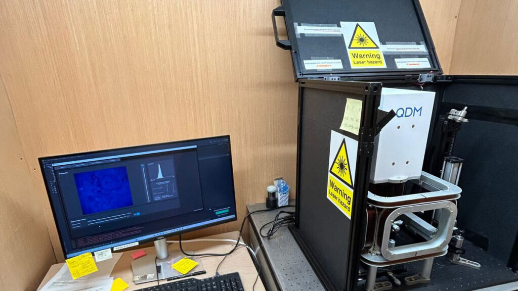
However, traditional bottle cap–sized bulk samples often contain a mixture of reliable and unreliable magnetic signals, resulting in complex data that hamper interpretation. To improve accuracy, researchers have turned to magnetic microscopy. This technique maps magnetic fields at submillimeter to submicrometer scales in thinly sliced rock sections using advanced tools like a quantum diamond microscope (QDM) or a cryogenic superconducting quantum interference device microscope. By creating high-resolution maps of individual magnetic particles, scientists can reconstruct ancient fields with much higher precision while filtering out muddy signals from unstable grains.
Despite its potential, magnetic microscopy is an emerging field with its own set of uncertainties. To help constrain measurement data, Bellon et al. combined QDM observations with computer modeling to analyze how a magnetic particle’s stray field—the magnetic flux that leaks into the surrounding space—decays as it moves away from the source. They specifically investigated how a particle’s internal magnetic structure and external measurement noise affect the accuracy of these reconstructions.
The study found that in iron oxides, the smallest and most magnetically stable particles produce signals that are strong at the source but fade rapidly with distance. In contrast, larger particles produce signals that remain detectable farther away. This creates a challenge: The most stable grains for long-term geological data (the smallest ones) are the hardest to detect if the sensor is not perfectly positioned or if sensor interference is present.
By quantifying measurement error, the authors provide a road map for the field of micropaleomagnetism. Their findings could allow researchers to better account for uncertainty, leading to more robust reconstructions of Earth’s magnetic history and a deeper understanding of planetary evolution. (Journal of Geophysical Research: Solid Earth, https://doi.org/10.1029/2025JB033133, 2026)
—Aaron Sidder, Science Writer
Citation: Sidder, A. (2026), Navigating the past with ancient stone compass needles, Eos, 107, https://doi.org/10.1029/2026EO260122. Published on 16 April 2026.
From rivers and oxbow lakes to crop-field patchworks and mineral sediments, Landsat has seen it all. A program of NASA and USGS, the satellite initiative has documented the Earth’s surface since 1972, making it the longest continuous record of our planet’s ever-evolving landscapes. And to mark Earth Day 2026, the organizations launched a playful way to interact with some of their findings collected over the past five-and-a-half decades—a name generator.
Using the tool is simple: type in yo
From rivers and oxbow lakes to crop-field patchworks and mineral sediments, Landsat has seen it all. A program of NASA and USGS, the satellite initiative has documented the Earth’s surface since 1972, making it the longest continuous record of our planet’s ever-evolving landscapes. And to mark Earth Day 2026, the organizations launched a playful way to interact with some of their findings collected over the past five-and-a-half decades—a name generator.
Using the tool is simple: type in your name, or any word, and Landsat returns it in the form of vertical snapshots of a wide range of terrain. Just like we see with composites of Mars, for instance, scientists have digitally enhanced some images to highlight specific features. Those used for “Your Name in Landsat” sport a wide array of hues, textures, and patterns that glimpse the diversity of our planet’s surface.
“Colossal”
Landsat is an incredible resource that features time-lapses of changing land use over several decades. Even this playful name generator allows you to hover over individual images and learn the exact locations—down to the coordinates—and all of the program’s data is publicly accessible. For example, the “C” in “Colossal” above is a vertical view of a cloud-speckled Deception Island in Antarctica, and the “A” is the uniquely shaped Lake Mjøsa in Norway.
You might also enjoy Overview, a book that chronicles how the landscape has changed over time. Learn more about Landsat from NASA. (via PetaPixel)
History or social studies is one of the more popular school subjects, but it isn't for everyone. Thankfully, many TV shows and movies tell past events through entertaining narratives, leaving out the monotone lectures. However, anime has also provided many historical series, whether based on real events like The Elusive Samurai or merely set during a major period like 91 Days.
History or social studies is one of the more popular school subjects, but it isn't for everyone. Thankfully, many TV shows and movies tell past events through entertaining narratives, leaving out the monotone lectures. However, anime has also provided many historical series, whether based on real events like The Elusive Samurai or merely set during a major period like 91 Days.
Editors’ Highlights are summaries of recent papers by AGU’s journal editors.
Source: Journal of Geophysical Research: Solid Earth
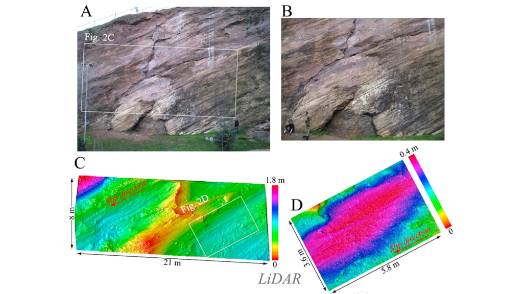
Earthquakes release energy and result in source properties defined across a wide range of scales that are not represented in conventional frictional laws. Norisugi and Noda [2026] introduce a new rate- and roughness-dependent friction (RRF) law which incorporates both effects from fault slip rate and multi-scale variation in fault topography. By limiting the nu
Source: Journal of Geophysical Research: Solid Earth
Earthquakes release energy and result in source properties defined across a wide range of scales that are not represented in conventional frictional laws. Norisugi and Noda [2026] introduce a new rate- and roughness-dependent friction (RRF) law which incorporates both effects from fault slip rate and multi-scale variation in fault topography. By limiting the number of state variables in the RRF formulation, the authors show with efficient earthquake cycle simulation that this multi-scale approach can reproduce a key observed relationship between fracture energy and fault slip.
Although further refinement is needed to better represent roughness evolution, this study marks a major advance in earthquake modeling by demonstrating the necessity and feasibility of incorporating multi-scale fault topography in the characterization of earthquake source process.
Citation: Norisugi, R., & Noda, H. (2026). Multi-scale rate- and roughness-dependent frictional constitutive law and dynamic earthquake sequence simulation. Journal of Geophysical Research: Solid Earth, 131, e2025JB033580. https://doi.org/10.1029/2025JB033580
A species of chimaera — aka a ghost shark — is among the 1,121 species scientists say they recently discovered as part of a marine exploration mission called Ocean Census. | The Nippon Foundation-Nekton Ocean Census/CSIRO
It lives in a glass castle deep under the sea.
It’s not a character from The Little Mermaid but a very real, very mysterious marine worm. Known as Dalhousiella yabukii, the worm resides inside a glass sea sponge — a simple marine animal that forms a glass-like skelet
A species of chimaera — aka a ghost shark — is among the 1,121 species scientists say they recently discovered as part of a marine exploration mission called Ocean Census. | The Nippon Foundation-Nekton Ocean Census/CSIRO
It lives in a glass castle deep under the sea.
It’s not a character from The Little Mermaid but a very real, very mysterious marine worm. Known as Dalhousiella yabukii, the worm resides inside a glass sea sponge — a simple marine animal that forms a glass-like skeleton — in the cold, dark waters off the coast of Japan. And it’s just one of a massive trove of marine animal species that scientists say they recently discovered.
This week, the Ocean Census — a project that has set out to accelerate the discovery of sea life — announced that it has found 1,121 previously unknown ocean species since last April. That marks a massive jump in the number of newly discovered marine species in a single year, according to Oliver Steeds, director of the Ocean Census, a joint mission of the UK-based nonprofit Nekton and Japan’s largest philanthropic organization, the Nippon Foundation. Some of the other newly found creatures include fish, rays, sponges, and soft corals (you can see more of them below).
Though it may seem that Earth is already largely explored, the vast majority of animal species on Earth — perhaps as many as 90 percent of them — remain undescribed. “This is really a planetary blindspot,” said Steeds, who’s also the founder and chief executive of Nekton.
The Ocean Census, which launched three years ago, is trying to close the gap in the marine realm by exploring remote ocean regions with the help of high-tech submersibles and taxonomists. And to that end, this large batch of species is an important step forward — with one major caveat.
Meet some of the weird creatures they found
While the search for life beyond Earth has been a magnet for public attention, missions like the Ocean Census reveal that there is a lot we still don’t know about life on our home planet — much of which looks pretty darn alien.
Most critters that the expeditions revealed are pretty small, like this striking ribbon worm. Found in the waters near Timor-Leste in Southeast Asia, the worm’s bright colors may be a signal to predators that it produces defensive toxins, according to a press release announcing the new findings. Such toxins may be useful in drug development; scientists have previously investigated chemicals produced by similar worms to treat cognitive disorders, such as Alzheimer’s disease.
Remarkably, the discovery effort also uncovered larger animals, which have likely managed to evade detection because they live at such great depths and in less-explored regions.
The most charismatic among them is, perhaps, this new species of “ghost shark” that scientists found off the coast of Australia. Though distantly related to sharks and rays, ghost sharks are not actually sharks at all but chimaeras, a deep-sea fish with a skeleton made of cartilage instead of bone.
In the same region, scientists also found an unknown species of ray…
…and an unfamiliar example of what’s known as a catshark. They’re bottom dwellers with slender bodies, and some of them apparently have a feline appearance (I’m not seeing it in this particular fish, which was found deep underwater in Australia.)
Then there are animals that don’t look like animals at all. Like this unfamiliar sea sponge found in the South Atlantic, not far from Antarctica. Belonging to a group of animals known as the ping-pong ball sponges (for obvious reasons), this animal is carnivorous and uses those balls — which are covered in tiny Velcro-like hooks — to entrap unsuspecting prey drifting by, such as small crustaceans.
Also in the South Atlantic, scientists found an unknown variety of “sea pen,” a kind of soft coral, more than 2,600 feet below the surface. It’s not one individual animal but a colony of thousands of genetically identical polyps, soft-bodied creatures with tentacles.
(You can see more of the alien-like species found through the Ocean Census here.)
Are these species actually new?
The announcement from the Ocean Census says that scientists “discovered” more than 1,100 “new” species in a single year. Those words must be taken with a grain of salt.
Proving that a species is new to science is difficult. It typically requires that taxonomists comb through existing museum collections and academic literature to demonstrate that, based on anatomical, genetic, or other traits, what they have has not been documented before. They can then submit their evidence for peer review and publication — the typical process through which a species is formally described and officially named, thus becoming a new species.
Many of the discoveries announced by the Ocean Census, however, have not yet gone through that level of due diligence and have not been formally described, according to Greg Rouse, a marine taxonomist at the Scripps Institution of Oceanography. That means it’s not clear that all of those species are, in fact, new to science.
As the Ocean Census points out in its announcement, the time between collecting a species and formally describing it as new takes about 13 years on average. That means some animals could go extinct before they’re even described in the scientific literature, the group says. “But that 13 years is there for a reason,” said Rouse, who isn’t involved in the Ocean Census project.
Formally describing and naming a species not only confirms that it’s new, but it also makes the species easier to study and conserve, such as through laws that protect named endangered species.
“The formal description process carries out the actual work to confirm novelty and provides the ‘passport’ for that new species — its official record,” said Tammy Horton, a research scientist at the UK’s National Oceanography Centre. “Without this, the formally recognized name, the species effectively does not exist for science, and therefore also for policy — unnamed species cannot be protected.”
Karen Osborn, a taxonomist at the Smithsonian National Museum of Natural History, similarly expressed skepticism about the announcement. Discovery alone is not enough, said Osborn, who’s not directly involved in the Ocean Census. “I don’t feel like saying, ‘Oh, look, we discovered something new’ should be given the status of something being described — until you’ve actually done the work to show that it’s something unique,” Osborn said. But, she said, “it’s a step in the right direction.”
A significant number of species uncovered by the Ocean Census and its partners are, in fact, already described in the scientific literature, Steeds, of Ocean Census, told me. He didn’t know how many. “It is not for us to do that,” he said of formally describing the species. (In many cases, taxonomists involved in the discoveries will later put in the time to formally describe them.) “Our job is discovery and to accelerate discovery,” Steeds said, which is the first step toward the formal new species description.
Horton, who’s also not directly affiliated with the Ocean Census, emphasized this point, too: “It is important to recognise that the identification or ‘discovery’ process is a fundamental part of the pipeline towards the ultimate goal of description of a species as new to science,” she told Vox. “You cannot have one without the other.”
Might some of these species not, in fact, be new? “It is something that we all need to be aware of,” Steeds told me. “Species discovery, species description are always a hypothesis — that’s the nature of it. And things do change.” (Horton suspects it’s not very common for taxonomists to believe something is new to science and later find out that it’s an individual of an already described species.)
If there’s one thing that the Ocean Census’s findings are helping reveal with absolute certainty, it’s that so much of the planet’s biodiversity remains a mystery. That’s exciting and hopeful.
“I would love people to know how much we don’t know about how much is out there,” Osborn said. “We’ve barely scratched the surface on understanding our world.”
When it comes to photo dumps, NASA has upped the ante. The organization has added thousands of snapshots from the Artemis II mission to the Gateway to Astronaut Photography of Earth archive. The album now holds 12,217 images by cosmic travelers Reid Wiseman, Victor Glover, Christina Koch, and Jeremy Hansen during their more than 250,000-mile, 10-day flyby mission around the moon.
According to PetaPixel, a couple of Nikons and an iPhone 17 were the cameras of choice for the journey. And eve
When it comes to photo dumps, NASA has upped the ante. The organization has added thousands of snapshots from the Artemis II mission to the Gateway to Astronaut Photography of Earth archive. The album now holds 12,217 images by cosmic travelers Reid Wiseman, Victor Glover, Christina Koch, and Jeremy Hansen during their more than 250,000-mile, 10-day flyby mission around the moon.
According to PetaPixel, a couple of Nikons and an iPhone 17 were the cameras of choice for the journey. And even though many of the thousands of recently uploaded images are very similar—some are even quite blurry—scrolling through them gives the impression of being seated right next to the “Moonfarers” as they marvel at Earth and its satellite and simply can’t put the camera down—just like we tend to snap way too many photos of a beautiful sunset.
Some of the most impactful photos include the reflections of the astronauts’ hands and faces in the window of their vehicle, the Orion module. Juxtaposed with meticulously engineered equipment, the earth and moon seem somehow less abstracted from this unique vantage point, in which these orbs appear somehow more resonant and precious—and vulnerable.
Explore more of our favorites below, and learn about the Artemis II mission on NASA’s site.
Scientists need your help! French researchers are calling on car drivers to help them measure the decline of insect populations – thanks to an app dubbed "Bugs Matter". The citizen science project was launched in April by France's National Museum of Natural History. It will become the country's first ever comprehensive assessment of insect populations. Our Down to Earth team reports.
Scientists need your help! French researchers are calling on car drivers to help them measure the decline of insect populations – thanks to an app dubbed "Bugs Matter". The citizen science project was launched in April by France's National Museum of Natural History. It will become the country's first ever comprehensive assessment of insect populations. Our Down to Earth team reports.
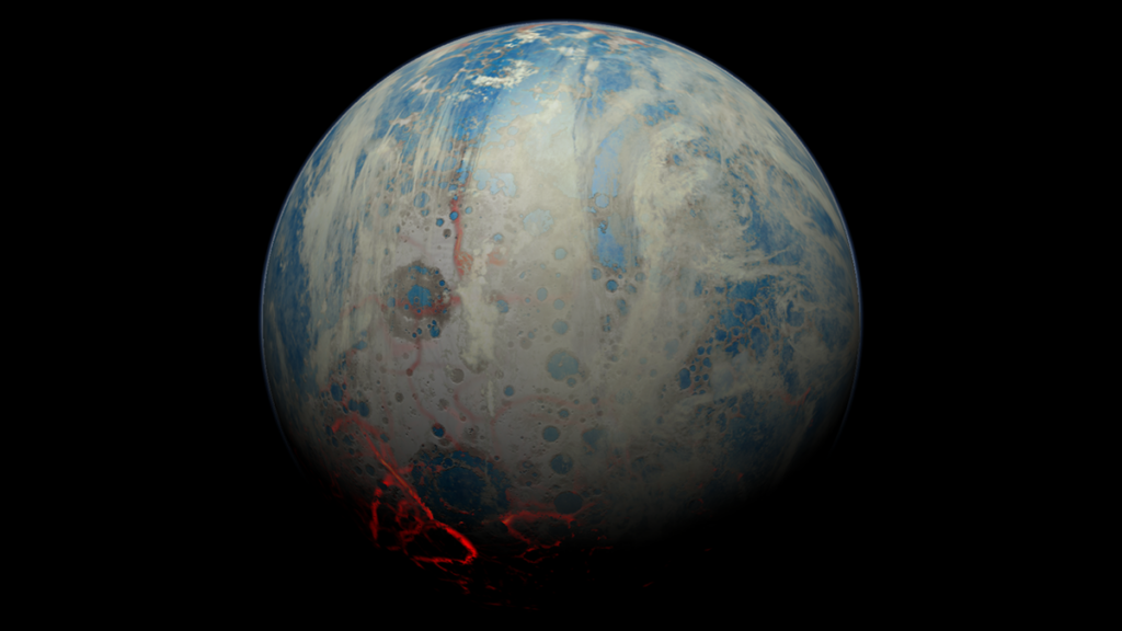
Source: AGU Advances
Asteroids and planetesimals regularly bombarded Earth between about 4.6 billion and 3.5 billion years ago, in the Hadean and Archean eons. Because few rocks today are more than 4 billion years old, our understanding of the planet’s environment during that time is limited. However, samples from the Moon and its cratered surface hint at the period’s rate of cosmic impacts.
Early asteroid strikes were responsible for significant changes in Earth’s crust, which was primar
Asteroids and planetesimals regularly bombarded Earth between about 4.6 billion and 3.5 billion years ago, in the Hadean and Archean eons. Because few rocks today are more than 4 billion years old, our understanding of the planet’s environment during that time is limited. However, samples from the Moon and its cratered surface hint at the period’s rate of cosmic impacts.
Early asteroid strikes were responsible for significant changes in Earth’s crust, which was primarily basalt-like at the time. The shock waves from collisions fractured the crust and increased porosity, allowing fluids and gases to move through the rocks. Prior research suggests that the resulting hydrothermal systems—such as the network of geysers around Yellowstone National Park—provided the environment for the origin and evolution of early life on Earth.
Alexander et al. explored how surface impacts during the Hadean and Archean allowed fluids and gases to maneuver through crustal environments. The authors built a large suite of impact simulations with the iSALE shock physics code, toggling parameters such as basalt crust thickness, geothermal gradients, and the presence or absence of a 5-kilometer-deep ocean. The simulations detailed how collisions on the surface shaped permeability in the crust. They then integrated a model for ancient bombardment data to understand the cumulative effects of repeated strikes over time.
The results indicate that prior to 4.3 billion years ago, impacts may have made the crust far more permeable, particularly in its top 8 kilometers. From the simulations, the authors inferred that the size of permeable regions was dependent on impact energy, and that geothermal gradients and rock composition in the crust affected the degree of fragmentation after impact. These porous domains formed potential settings for prebiotic chemistry within the early crust.
The research is the first comprehensive study of impact-generated permeability in early Earth’s outermost layer. The results provide a novel framework for evaluating how bombardment influenced hydrothermal circulation and geochemical alteration during the Hadean and Archean eons, with implications for our understanding of life’s origin and evolution in Earth’s earliest days. (AGU Advances, https://doi.org/10.1029/2025AV002097, 2026)
—Aaron Sidder, Science Writer
Citation: Sidder, A. (2026), Cosmic bombardment created potential for prebiotic chemistry, Eos, 107, https://doi.org/10.1029/2026EO260180. Published on 5 June 2026.
The end of the world is nigh, or at least that seems to be a warning based on the flood of apocalyptic and post-apocalyptic TV shows being released over the last few decades, particularly in recent years. In each of the shows, the world has come to an end through some form of tragic circumstance: a nuclear war, a deadly virus, an alien invasion, or even a zombie takeover.
The end of the world is nigh, or at least that seems to be a warning based on the flood of apocalyptic and post-apocalyptic TV shows being released over the last few decades, particularly in recent years. In each of the shows, the world has come to an end through some form of tragic circumstance: a nuclear war, a deadly virus, an alien invasion, or even a zombie takeover.