Normal view

Vast Space, Sparse Data: An AI Answer to Twin Space Weather Challenges

Artist’s illustration showing part of the Sun at left, Earth and its magnetosphere at right, and several spacecraft in between. The spacecraft are networked together by curving, glowing green lines.

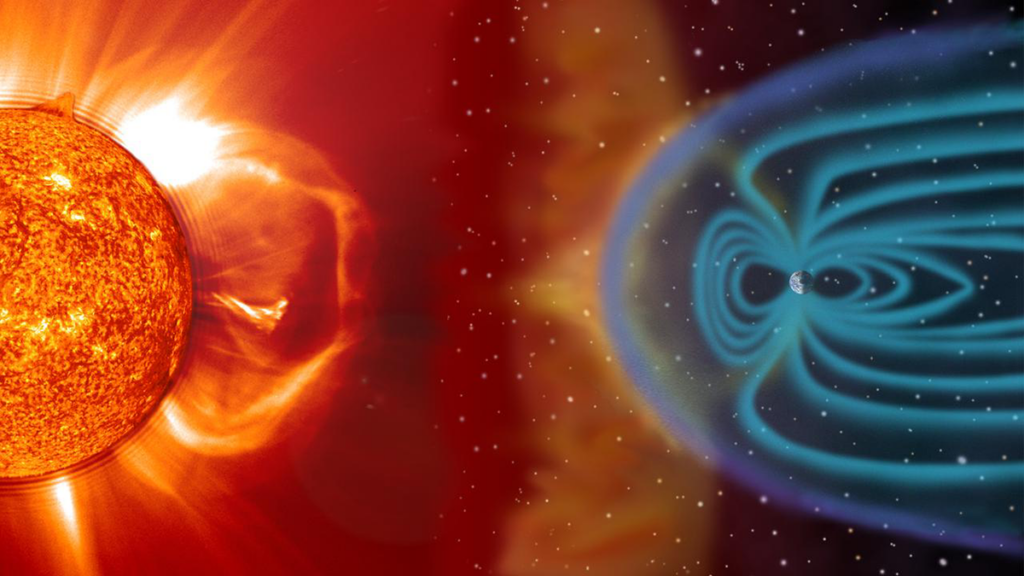
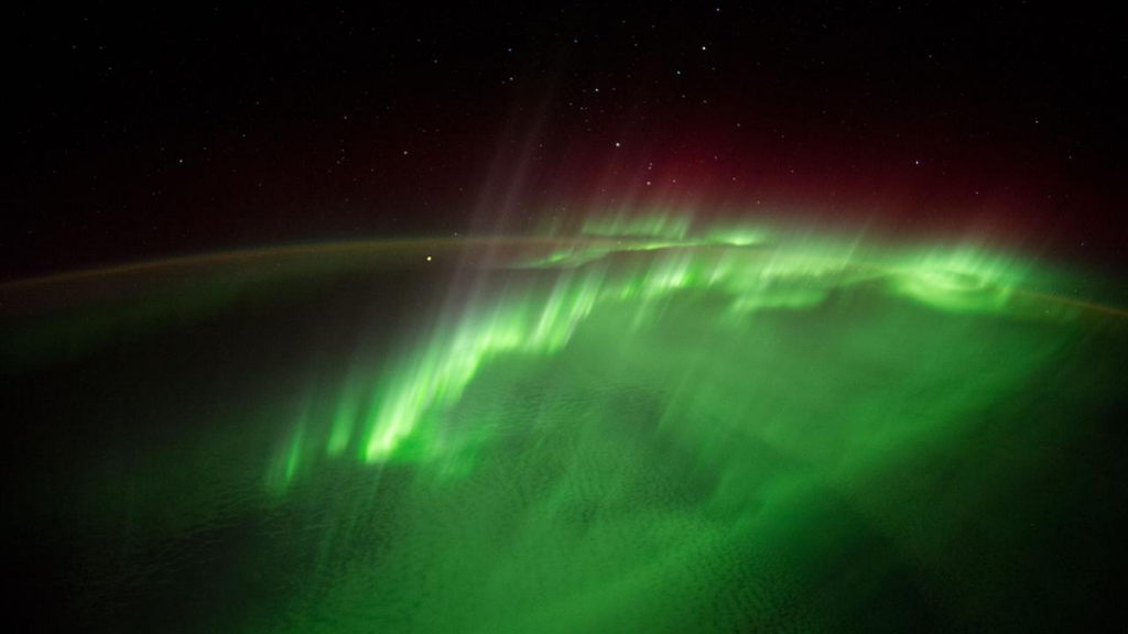
Solar activity affecting Earth and its planetary neighbors encompasses a wide range of phenomena, from the steady solar wind and the interplanetary magnetic field to extreme events like solar flares, coronal mass ejections (CMEs), and solar energetic particle (SEP) events. These space weather phenomena interact in complex ways with planetary magnetospheres and atmospheres. On Earth, we see the results in the dancing lights of stunning auroras and in less frequent but sometimes severe disruptions to telecommunications, navigation, and energy infrastructure.

Forecasting conditions throughout the heliosphere (the region influenced by the solar wind), understanding the variety of Sun-Earth interactions, and predicting arrivals of space weather events—both benign and potentially hazardous—are a grand challenge.

The Sun-Earth challenge requires tracking and predicting conditions—from routine and quiet to rare and extreme—across tens of millions of kilometers of interplanetary space.

Solar flares emit electromagnetic radiation that spreads in all directions. In contrast, the propagation of CMEs and SEP events depends on their source location on the Sun and on the heliospheric magnetic field, which is carried outward by the solar wind. The impacts these events have on magnetosphere systems further vary depending on particle energies and intensities in SEPs and on particle speeds and the magnetic field orientation in CMEs. The Sun-Earth challenge thus requires tracking and predicting conditions—from routine and quiet to rare and extreme—across tens of millions of kilometers of interplanetary space.

This tracking and prediction is powered by petabyte-scale datasets from solar observatories and spacecraft measurements that provide rich observational archives. Researchers use these data to deduce physically meaningful quantities describing the heliosphere and to identify patterns to distinguish quiet from active conditions. The resulting insights not only answer fundamental science questions but also provide critical prediction time frames needed by space weather forecasters.

Even with all these data, the enormity of space between the Sun and Earth presents a major obstacle to our predictive capabilities. Another obstacle is that the data are obtained by different instruments operating at different locations and times. These factors combine to create a unique data sparsity challenge that complicates large-scale analysis.

These fundamental issues—the massive yet still insufficient supply of data available, the extreme differences in the scales of the processes we must illuminate, and the need for actionable predictions—suggest opportunities for artificial intelligence (AI) and machine learning (ML) to complement traditional physics-based analytical approaches [Camporeale, 2019]. In a series of workshops—insights from which inform the discussion below—scientists explored such opportunities and how they can advance heliophysics research and operational space weather forecasting.

The Need for Space Weather Forecasting

Space weather events can have significant impacts on infrastructure and humans. They can disrupt satellite operations (e.g., by enhancing atmospheric drag on satellites), damage electronics in space, interfere with radio communications and GPS, and even affect power grids (e.g., through geomagnetically induced currents) during the most severe events. They can also pose risks to people, especially astronauts beyond the protection of Earth’s atmosphere and airline crews and passengers on long-distance polar flights, during which exposure to energetic particles is elevated. Forecasting offers a first line of defense in preparing for or preventing damaging and hazardous effects of space weather.

In assessing major CMEs, forecasters consider whether and when events will reach Earth and whether they will trigger geomagnetic storms and substorms. For SEP events, predictions must include arrival times, peak intensities, durations, and energy characteristics.

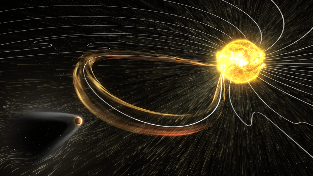
Predicting extreme space weather phenomena is vital, but equally important is forecasting periods when no significant activity is expected, which is critical information for satellite operators and other stakeholders. Making such predictions requires understanding physics spanning 8 orders of magnitude in space and time, from subsecond processes in Earth’s magnetic environment to multiday solar eruptions propagating across the 150 million kilometers between the Sun and Earth (Figure 1) and long-term interactions at scales associated with the 11-year solar cycle.

Diagram illustrating how length scales and Sun-to-Earth transit times vary greatly for different types of space weather, including solar flares, solar energetic particle events, coronal mass ejections, and interplanetary coronal mass ejections
Fig 1. Length scales and Sun-to-Earth transit times vary greatly for different types of space weather (SW), including solar flares, solar energetic particle (SEP) events, coronal mass ejections (CMEs), and interplanetary coronal mass ejections (ICMEs). High-speed particles are the first to arrive, usually within minutes of a flare, whereas CMEs arrive in 2–4 days. Credit: Georgoulis et al. [2026], CC BY-NC-ND 4.0

In addition to operational forecasting, these challenges are fundamental in heliophysics research. Such research includes work to reveal how the Sun generates its magnetic field, how solar wind accelerates and evolves, how planetary magnetospheres respond to external forcing, how particles are accelerated, and how energy transfers across multiple scales and regimes.

Unique Challenges in Heliophysics

Modern AI and ML algorithms excel at analyzing well-curated, extensive datasets that include millions of training examples. For example, AI-aided terrestrial weather forecasting relying on continuous, high-resolution coverage from thousands of ground stations, weather balloons, and satellites has advanced dramatically in recent years.

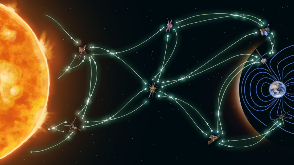
Fewer than a dozen spacecraft monitor Earth’s magnetosphere, a region spanning tens of Earth radii. Solar wind observations are even sparser.

Heliophysics, however, presents a unique and somewhat opposite scenario. Fewer than a dozen spacecraft monitor Earth’s magnetosphere, a region spanning tens of Earth radii (about 6,371 kilometers). Solar wind observations are even sparser, with just a handful of monitors scattered across the space between the Sun and Earth. This fundamental scarcity poses a challenge for data-driven approaches, which typically depend on abundant observations that are well distributed in space and time to produce trustworthy (i.e., generalizable and reproducible) models.

Data sparsity is further compounded by the relative rarity of intense space weather phenomena such as CMEs, major geomagnetic storms, and extreme substorms, which occur only a few times per solar cycle. Most heliophysical observations capture quiet, low-activity conditions when the solar wind is steady and magnetospheres are calm. Standard ML approaches trained on such imbalanced datasets may achieve high statistical accuracy by simply predicting a “nothing-will-happen” outcome but completely fail when extreme events occur.

Although solar eruptions and geomagnetic storms are relatively rare, they exhibit recurring patterns and consistency in their physical drivers. This regularity suggests that historical observations, when properly clustered and analyzed, can be used to enhance prediction capabilities. The challenge therefore lies in extracting meaningful patterns from sparse measurements of rare events while avoiding models that work well for average conditions but fail when they matter most [Chu et al., 2025].

AI Solutions for Data Sparsity

Heliophysics research employs clever approaches to extract maximum information from the limited available observations. One strategy is to mine multidecade observational records from various satellites and to match and group together measurements collected at times with similar solar wind and geomagnetic activity conditions.

This process clusters tens of thousands of data points from similar magnetospheric states. Such clustering enables reconstruction of dynamic features like nightside magnetic field changes during substorms [Stephens et al., 2019] and the presence of near-Earth magnetotail reconnections [Angelopoulos et al., 2020].

Another, more universal approach is to embed fundamental physical laws directly into ML models through physics-informed neural networks [Raissi et al., 2019], ensuring that predictions respect physical reality even when training data are limited. Data assimilation techniques used in weather forecasting similarly blend sparse observations with physics-based simulations and update models as new measurements arrive.

This animated model shows Earth’s magnetosphere during a powerful May 2024 geomagnetic storm that involved strong solar flares and multiple CMEs. The visualization uses the Multiscale Atmosphere-Geospace Environment (MAGE) model from the Johns Hopkins Applied Physics Laboratory to depict wind rushing toward Earth and disturbing its magnetic field (orange and purple lines). The green cloud represents electric field current intensity; the blue squiggles are tracers of solar wind velocities. Credit: NASA Scientific Visualization Studio and NASA DRIVE Science Center for Geospace Storms

These methods converge on a common theme: building gray box models (so named because they’re less opaque than black box models) that are data driven but grounded in physically real constraints. For data-starved applications, hybrid approaches can outperform purely data-driven or purely physics-based methods [Liu et al., 2025].

Satellite instruments are generating increasingly large solar wind datasets. However, the variables obtained (e.g., solar wind speed and pressure) are highly intercorrelated [Borovsky, 2018], making it difficult to identify which ones truly drive magnetospheric responses. New algorithms are helping to distill datasets without losing critical scientific information [e.g., Camporeale, 2025]. Meanwhile, advanced statistical and ML methods can cut through dataset complexity by reducing dimensionality, identifying causal relationships among variables, and providing clues about dominant drivers.

For instance, information theory provides tools to detect dependencies in complex systems, establish causality, and rank variables that most effectively predict space weather outcomes [Wing et al., 2022]. Such techniques can be paired with other “explainable” tools, such as SHAP (SHapley Additive exPlanations) values, a method inspired by game theory, to pinpoint physical variables (e.g., solar wind speed or magnetic orientation) that drive a prediction [Ma et al., 2023].

Distilling datasets and improving model interpretability help make ML more practical and more scientifically trustworthy and its predictions more robust. But fully trusting ML models in operational environments requires rigorous validation and uncertainty quantification. These models must not only make predictions but also indicate their confidence levels for operational decisionmaking.

When a model forecasts a major geomagnetic storm, operators need to know whether that prediction carries 60% or 95% confidence, for example.

When a model forecasts a major geomagnetic storm, operators need to know whether that prediction carries 60% or 95% confidence, for example. Ensemble approaches, in which multiple models provide a range of outcomes, help quantify this uncertainty, while using standardized, well-documented datasets enables fair model intercomparisons.

The research community is developing ML-ready benchmark datasets with consistent formatting and clear metadata to establish such validation procedures [e.g., Angryk et al., 2020]. These resources allow researchers to test new algorithms against common baselines, accelerating progress while ensuring that advances are robust and reproducible rather than artifacts of specific data processing choices.

Notably, one domain in heliophysics that is not affected by severe data sparsity is solar imaging. Decades of continuous, high-resolution observations from the Solar Dynamics Observatory (SDO), which delivers 1.5 terabytes of data every day, have created enormous data archives. Because the Sun drives space weather throughout the heliosphere, these datasets offer an ideal opportunity for use in foundation models, large-scale ML systems trained to learn comprehensive internal representations that can then be easily adapted to specific scientific tasks with minimal additional training.

Surya, a foundation model designed to construct a digital representation of the Sun, represents one such effort. It is still in early development and has yet to be validated, but this approach illustrates how data-rich domains can be leveraged with modern AI techniques to create tools that broadly benefit heliophysics research and space weather forecasting.

Advancing Research and Operational Forecasting Together

In addition to the needs for data and model development and validation, applying AI to address the challenges of heliophysics requires sustained, multidisciplinary collaborations. Fostering those collaborations has been the focus of a series of workshops, with the most recent being 2025’s Machine Learning, Data Mining and Data Assimilation in Geospace (LMAG25) meeting at the Johns Hopkins University Applied Physics Laboratory. The workshops have brought together heliophysicists, machine learning experts, data scientists, and specialists from weather forecasting and applied mathematics to exchange knowledge and establish community standards.

Space weather forecasters need models that are accurate and interpretable and that provide not just statistical metrics but also actionable predictions.

The LMAG forums also serve as gathering spaces for scientists to validate models against diverse datasets, compare physics-based and data-driven approaches, develop performance benchmarks, and discuss how to bridge research and operational requirements. Space weather forecasters need models that are accurate and interpretable and that provide not just statistical metrics but also actionable predictions with known limitations and reliability. Of course, researchers also benefit. These conversations allow them to gain insight into operational constraints that shape how modeling approaches become practical in real-world settings.

LMAG and similar initiatives facilitate direct exchanges among adjacent communities, including by making meeting presentations openly available. These efforts are helping translate cutting-edge AI and ML techniques into practical tools that help protect critical infrastructure and human well-being. They are also deepening our understanding of how the Sun shapes space weather throughout the solar system and its effects—both mundane and major—on Earth.

References

Angelopoulos, V., et al. (2020), Near-Earth magnetotail reconnection powers space storms, Nat. Phys., 16(3), 317–321, https://doi.org/10.1038/s41567-019-0749-4.

Angryk, R. A., et al. (2020), Multivariate time series dataset for space weather data analytics, Sci. Data, 7(1), 227, https://doi.org/10.1038/s41597-020-0548-x.

Borovsky, J. E. (2018), The spatial structure of the oncoming solar wind at Earth and the shortcomings of a solar-wind monitor at L1, J. Atmos. Sol. Terr. Phys., 177, 2–11, https://doi.org/10.1016/j.jastp.2017.03.014.

Camporeale, E. (2019), The challenge of machine learning in space weather: Nowcasting and forecasting, Space Weather, 17(8), 1,166–1,207, https://doi.org/10.1029/2018SW002061.

Camporeale, E. (2025), PARIS: Pruning Algorithm via the Representer theorem for Imbalanced Scenarios, arXiv:2512.06950, https://doi.org/10.48550/arXiv.2512.06950.

Chu, X., et al. (2025), Imbalanced Regression Artificial Neural Network Model for Auroral Electrojet Indices (IRANNA): Can we predict strong events?, Space Weather, 23(5), e2024SW004236, https://doi.org/10.1029/2024SW004236.

Georgoulis, M. K., et al. (2026), Prediction of solar energetic events impacting space weather conditions, Adv. Space Res., in press, https://doi.org/10.1016/j.asr.2024.02.030.

Liu, Y., et al. (2025), Data-driven modeling of electrostatic turbulence by physics-informed Fourier neural operator, Mach. Learn. Sci. Technol., 6(4), 045050, https://doi.org/10.1088/2632-2153/ae19cd.

Ma, D., et al. (2023), Opening the black box of the radiation belt machine learning model, Space Weather, 21(4), e2022SW003339, https://doi.org/10.1029/2022SW003339.

Raissi, M., P. Perdikaris, and G. E. Karniadakis (2019), Physics-informed neural networks: A deep learning framework for solving forward and inverse problems involving nonlinear partial differential equations, J. Comput. Phys., 378, 686–707, https://doi.org/10.1016/j.jcp.2018.10.045.

Stephens, G. K., et al. (2019), Global empirical picture of magnetospheric substorms inferred from multimission magnetometer data, J. Geophys. Res. Space Phys., 124(2), 1,085–1,110, https://doi.org/10.1029/2018JA025843.

Wing, S., et al. (2022), Modeling radiation belt electrons with information theory informed neural networks, Space Weather, 20(8), e2022SW003090, https://doi.org/10.1029/2022SW003090.

Author Information

Savvas Raptis (savvas.raptis@jhuapl.edu), Manolis K. Georgoulis, Mikhail Sitnov, Anthony Sciola, and Simon Wing, Johns Hopkins University Applied Physics Laboratory, Laurel, Md.

Citation: Raptis, S., M. K. Georgoulis, M. Sitnov, A. Sciola, and S. Wing (2026), Vast space, sparse data: An AI answer to twin space weather challenges, Eos, 107, https://doi.org/10.1029/2026EO260188. Published on 11 June 2026.
Text © 2026. The authors. CC BY-NC-ND 3.0
Except where otherwise noted, images are subject to copyright. Any reuse without express permission from the copyright owner is prohibited.
  • ✇Eos
  • Mapping the Hidden Electrical Anatomy of a Continent Paul A. Bedrosian · Anna Kelbert · Adam Schultz and Gary D. Egbert
    Editors’ Vox is a blog from AGU’s Publications Department. After 18 years of data collection, quality control, processing, and archiving, the United States Magnetotelluric Array (USMTArray) data set was completed in 2024. A new article in Reviews of Geophysics introduces this unprecedented data set and a new high-resolution model of the Earth’s crust and upper mantle that was made possible because of it. Here, we asked the authors to give an overview of magnetotellurics, how the USMTArray wa
     

Mapping the Hidden Electrical Anatomy of a Continent

Photo of a scientists installing equipment in the field.
Editors’ Vox is a blog from AGU’s Publications Department.

After 18 years of data collection, quality control, processing, and archiving, the United States Magnetotelluric Array (USMTArray) data set was completed in 2024. A new article in Reviews of Geophysics introduces this unprecedented data set and a new high-resolution model of the Earth’s crust and upper mantle that was made possible because of it. Here, we asked the authors to give an overview of magnetotellurics, how the USMTArray was developed, and future directions for research.

In simple terms for a non-specialist, what is the science of magnetotellurics?

Magnetotellurics (MT) is a passive geophysical technique capable of imaging the subsurface from hundreds of meters to hundreds of kilometers depth using the Sun and global lightning as sources. The science behind MT is largely based on Faraday’s law of induction, where external magnetic field variations induce telluric (from the Latin word ‘tellus’ meaning Earth) currents in the conducting Earth. These magnetic field variations are constantly occurring and happen over a wide range of time scales ranging from milliseconds to hours. And they are tiny – typically on the order of 0.1% of Earth’s magnetic field amplitude and even during intense magnetic storms rarely exceed 1%. 

By measuring these magnetic variations, and the induced electric field variations at Earth’s surface, we can constrain the 3D distribution of conductivity in the Earth. MT is an elegant method – we exploit powerful and distant energy sources which we have no control over and can mathematically remove the stochastic source spectrum to recover reliable estimates of Earth impedance. Impedance can be thought of as the Earth filter – a complex, frequency dependent set of functions that encapsulates all the information about the 3D conductivity structure beneath our feet. Through numerical inversion of impedance data at an array of sites, we build up 3D models of electrical conductivity.

What are some of the applications of the magnetotelluric method?

MT is applied across a broad spectrum of the Earth and space sciences ranging from mineral and geothermal resource investigations, to fundamental geologic and tectonic studies, to imaging the magmatic plumbing systems of active volcanoes, and to hazard mapping centered upon geomagnetically induced currents and the risk they pose to power grids.

Studies using MT are performed on every continent and in all tectonic settings, on land and on the ocean floor, on the Antarctic ice sheet, and even on the Moon. Because of its ability to image the entire lithospheric column, MT studies have made important contributions to our understanding of continental assembly by revealing ancient orogens and rifts. Moreover, MT is uniquely able to constrain the stability of cratonic roots by mapping hydration of the mantle lithosphere. MT studies are key to understanding active tectonic processes, including constraining the water budget in subduction zones, imaging melt zones beneath orogenic plateaus, and mapping the extent of crustal extension – for example beneath the western U.S.

Installation of a USMTArray site in the arid southwestern United States. Sites are installed in remote areas far from infrastructure (powerlines and pipelines) which can interfere with magnetotelluric measurements. Credit: Lena Tokmakoff

With the rise of computational power and 3D modeling and inversion codes, MT is now routinely used to study complex 3D systems, such as active volcanoes, geothermal systems, and mineral deposits. The sensitivity of MT to minor conductive phases – be it partial melt, clay, or conductive minerals such as graphite and metallic sulfides – make it ideal for studying these types of systems. As a result, MT is commonly employed within the resource sector at both the district and deposit scale. Many of the world’s iconic volcanoes have also been imaged with MT, where they constrain the geometry of crustal melt reservoirs – especially their volume and melt fraction which is in turn linked to the eruptibility of a subsurface magma. These analyses are especially powerful because they are sensitive to a distinct physical parameter – resistivity – of Earth materials. MT therefore provides unique and complementary information about the subsurface across a wide range of scales and is a particularly invaluable tool when other methods yield non-unique interpretations. 

One somewhat unexpected application of MT has been to space weather hazards. It was recognized a little over a decade ago that MT impedances are key to estimating surface electric fields generated during intense geomagnetic storms that can impact electric power grids. Past storms have knocked out power to vast areas and damaged critical infrastructure such as transformers. The importance of MT data to scenario analysis, in which power grid components are ‘stress tested’ against past geomagnetic storms, cannot be overstated. Regional to national-scale geoelectric hazard maps, both in the U.S. and internationally, are also informed by MT data, as are real-time geoelectric hazard estimates.

What is the United States Magnetotelluric Array (USMTArray)?

The USMTArray was an ambitious program begun in 2006 under the NSF-funded EarthScope program and completed in June of 2024 under USGS funding. The USMTArray collected long-period MT soundings on a 70-km grid across the contiguous U.S. – totaling more than 1,800 stations – each collected with uniform instrumentation, acquisition parameters, data processing, archiving, and metadata. Funded throughout its 18-year lifetime by three different federal agencies (the NSF, NASA, and USGS working closely with the Incorporated Research Institutions for Seismology and Oregon State University), the data – time series, response functions and metadata – were released incrementally to the public without data embargo or usage restriction.

Map of USMTArray site locations illustrating how the survey rolled across the country over its nearly two-decade lifetime. Credit: Kelbert et al. [2026], Figure 1

In broad terms, how was the USMTArray developed?

The USMTArray had humble beginnings – being mentioned in early planning documents as having value in understanding subduction zones and characterizing volcanic systems. Funded by NSF in 2003, the MT component of EarthScope was modeled after the much larger seismic component, with a transportable array of instruments to march across the U.S. on a 70-km spaced grid and a backbone array of seven instruments to study deep mantle structure. The USMTArray started off small and before dedicated instruments were even available. In 2006, a pilot study collected the first 30 stations in eastern Oregon using borrowed instruments, while subsequent years expanded what became known as the ‘northwest’ footprint, a 331-sites array completed in 2011 encompassing the Yellowstone-Snake River Plain, the Northern Rocky Mountains, the Cascades magmatic arc, and the northern Basin and Range province. Subsequent footprints in the midcontinent and the eastern U.S. continued to expand coverage.

What were some of the challenges in developing the USMTArray?

The biggest challenge by far was money. Within the EarthScope program, the USMTArray was never funded at the level needed to cover the contiguous U.S. The MT component was instead carried out as a series of footprints in areas deemed most scientifically advantageous. This limitation, however, led to one of the big successes of the USMTArray – active community engagement. Siting workshops held in 2008 and 2013 brought together participants from academia, government, and industry to discuss and prioritize where the array would go next, while a community working group provided scientific and operational guidance throughout the life of the array. The success of the USMTArray was recognized early on by the community governance of the EarthScope facility activities, with the ‘full-48’ concept endorsed in 2009, leading to modest increases in funding and an acceleration of station completions. In 2018, by the end of NSF-sponsored activities, roughly 2/3 of the contiguous U.S. had been covered. Seeing the array to completion, however, required additional funding, a challenge met by NASA (2019-2020) and the USGS (2020-2024), in large part due to recognition of the importance of USMTArray data to space-weather hazards and supported through executive orders in 2016 and 2019.

Another notable challenge that we faced while developing the USMTArray operations was the absence of established data sharing practices within the magnetotelluric community. Indeed, the concept of FAIR data was only introduced in 2016. Back in 2006 when this program commenced, the concepts of open data and systematic data sharing were largely unfamiliar, and no widely adopted, sustainable data formats existed. Available data formats were lacking in flexibility, consistency, and self-descriptive metadata. As the project progressed, our team developed such formats and accompanying databases, which have now reached maturity and are helping to drive more sustainable MT data‑sharing practices internationally.

How has the development of the USMTArray advanced the scientific field?

The USMTArray, along with parallel advances in modeling capabilities and increased computational power, ushered in a jump to 3D MT and to interrogating the Earth at regional to national scales. National-scale conductivity models, such as those developed from the USMTArray, now join the ranks of other data sets like magnetic, gravity, and seismic, and are a new lens with which to view the architecture of the North American continent. Numerous contributions to continental architecture and assembly and to understanding active tectonic processes have come from the USMTArray.

Map of the United States underground electrical structure integrated over mid- to lower crustal depths, illustrating the resistive (dark) and conductive (hot) regions. The latter reflects ancient tectonic scars within the crust. Credit: Kelbert et al. [2026], Figure 17

The USMTArray also serves as a framework for more detailed studies, allowing Principal Investigators (PIs) to derisk future surveys and industry to investigate anomalous or unexpected structure. Studies of the Cascadia subduction zone and the adjacent magmatic arc and geothermal energy prospectivity studies in the Oregon Cascades and Great Basin have been built upon the USMTArray while new MT surveys along the eastern seaboard are collecting high-resolution MT data to improve space-weather hazard maps over areas identified as particularly at risk from the analysis of USMTArray data.

Beyond the data and models derived from them, the USMTArray has motivated methodological advances, led to an investment in MT instrumentation and open-source software for researchers within the NSF-supported National Geophysical Facility, and served as a model for other regional and continental scale MT experiments.

What are some of the future directions for research in continental scale magnetotellurics?

With completion of the USMTArray, and the 3D conductivity models derived from it, there are numerous avenues for future research. Most models of continental evolution, for example, were developed prior to the advent of this rich data set. Critically evaluating such models in light of this new data set is paramount, and initial studies are already forcing a reexamination of certain paradigms.  

Multi-disciplinary studies incorporating geochronology, geochemistry, and rapidly evolving seismic models is another promising area as is the coupling of geophysical models to geodynamic models to examine the evolution of newly imaged model structure. Similarly, advancements in integrated and joint inversion are promising directions to leverage the wealth of public data sets available at regional to continental scales.  

Geology doesn’t stop at national borders or the land-sea interface – additional opportunities exist for cross-border arrays and onshore/offshore MT studies. Investigation of subduction zone processes and rifted continental margins by their very nature demand an amphibious approach.

On the applied front, resource assessments increasingly are applied at national and even global scales and demand data support at these same scales. Mineral resource assessments, for example, in the U.S., Canada, and Australia are exploring machine learning approaches to map prospectivity for various deposit types and incorporate a range of geophysical data layers to do so. Similarly, geothermal assessments can benefit from the consistent and synoptic data coverage offered by USMTArray data and models.

Finally, on the space-weather hazards front, partnering with power-system engineers to investigate data scale and uncertainty shows promise in generating accurate hazard maps and in improving upon operational, near real-time geoelectric field models. For all these future research directions the USMTArray remains both a framework and a benchmark upon which to build.

—Paul A. Bedrosian (pbedrosian@usgs.gov; 0000-0002-6786-1038), U.S. Geological Survey, United States; Anna Kelbert (anna.kelbert@cfa.harvard.edu; 0000-0003-4395-398X), Center for Astrophysics | Harvard & Smithsonian, United States; Adam Schultz (adam.schultz@oregonstate.edu; 0000-0003-1663-1547), Oregon State University, United States; and Gary D. Egbert (gary.egbert@oregonstate.edu; 0000-0003-1276-8538), Oregon State University, United States

Editor’s Note: It is the policy of AGU Publications to invite the authors of articles published in Reviews of Geophysics to write a summary for Eos Editors’ Vox.

Citation: Bedrosian, P. A., A. Kelbert, A. Schultz, and G. D. Egbert (2026), Mapping the hidden electrical anatomy of a continent, Eos, 107, https://doi.org/10.1029/2026EO265021. Published on 26 May 2026.
This article does not represent the opinion of AGU, Eos, or any of its affiliates. It is solely the opinion of the author(s).
Text © 2026. The authors. CC BY-NC-ND 3.0
Except where otherwise noted, images are subject to copyright. Any reuse without express permission from the copyright owner is prohibited.
  • ✇Eos
  • 6.16亿年前波罗的大陆在哪里? Saima May Sidik
    Source: Geochemistry, Geophysics, Geosystems This is an authorized translation of an Eos article. 本文是Eos文章的授权翻译。 大约 6 亿年前,各大洲在地球上漂移,尚未最终定格在现在的位置。在埃迪卡拉纪时期,各大洲的位置对于科学家来说一直难以确定。地球的磁场似乎表现得异常不稳定,而利用标准方法根据磁场记录来计算大陆位置的做法却得出了一些难以置信的结果。尤其是,科学家们对一块名为波罗的大陆的古老大陆的位置存在争议,这块大陆如今是欧洲的一部分。 为了探究这一问题,Xue等人前往挪威埃格尔松德,采集了波罗的大陆地壳被撕裂、岩浆从下方涌出时形成的岩石样本。随着这些岩浆冷却凝固,它们记录了地球磁场的瞬时变化,并在此过程中存储了有关波罗的大陆位置的信息。 对这些样本的研究结果揭示了远比科学家们最初设想的更为复杂的古代岩石图景。这些岩石中至少包含了六种不同的磁信号,构成了一幅复杂的混合图景。其中一些信号似乎是在更现代的地质过程改变原始岩石时形成的。埃迪卡拉纪时期可能保存了三种
     

6.16亿年前波罗的大陆在哪里?

3 June 2026 at 12:42
两个人,一个穿着黄色背心,一个穿着灰色长袖衬衫,正抬头看着一块岩石表面。
Source: Geochemistry, Geophysics, Geosystems

This is an authorized translation of an Eos article. 本文是Eos文章的授权翻译。

大约 6 亿年前,各大洲在地球上漂移,尚未最终定格在现在的位置。在埃迪卡拉纪时期,各大洲的位置对于科学家来说一直难以确定。地球的磁场似乎表现得异常不稳定,而利用标准方法根据磁场记录来计算大陆位置的做法却得出了一些难以置信的结果。尤其是,科学家们对一块名为波罗的大陆的古老大陆的位置存在争议,这块大陆如今是欧洲的一部分。

为了探究这一问题,Xue等人前往挪威埃格尔松德,采集了波罗的大陆地壳被撕裂、岩浆从下方涌出时形成的岩石样本。随着这些岩浆冷却凝固,它们记录了地球磁场的瞬时变化,并在此过程中存储了有关波罗的大陆位置的信息。

对这些样本的研究结果揭示了远比科学家们最初设想的更为复杂的古代岩石图景。这些岩石中至少包含了六种不同的磁信号,构成了一幅复杂的混合图景。其中一些信号似乎是在更现代的地质过程改变原始岩石时形成的。埃迪卡拉纪时期可能保存了三种不同的信号,其中两种与将波罗的板块置于赤道附近的最合理的埃迪卡拉纪信号相悖。这些相互矛盾的信号进一步支持了地球磁场在当时异常活动的观点,使原本就扑朔迷离的图景更加复杂。

基于新的研究结果,研究人员将埃迪卡拉纪时期埃格尔松德古地磁极的位置确定在北纬20.8°、东经89.0°——这与之前的研究结果有所不同——并提出波罗的板块当时位于赤道附近,毗邻古老的劳伦古陆,但相对于之前的重建结果,其位置略有顺时针旋转。这项研究表明,保存在古代岩石中的磁信号极其复杂,并凸显了将这些记录分解成各个组成部分的重要性。研究人员认为,这样做可以为埃迪卡拉纪时期地球磁场的神秘行为提供新的线索。(Geochemistry, Geophysics, Geosystemshttps://doi.org/10.1029/2025GC012730, 2026)

—科学撰稿人Saima May Sidik (@saimamay.bsky.social)

This translation was made by Wiley. 本文翻译由Wiley提供。

Read this article on WeChat. 在微信上分享本文。

A photo of a telescope array appears in a circle over a field of blue along with the Eos logo and the following text: Support Eos’s mission to broadly share science news and research. Below the text is a darker blue button that reads “donate today.”
Text © 2026. AGU. CC BY-NC-ND 3.0
Except where otherwise noted, images are subject to copyright. Any reuse without express permission from the copyright owner is prohibited.
  • ✇Eos
  • Navigating the Past with Ancient Stone Compass Needles Aaron Sidder
    Source: Journal of Geophysical Research: Solid Earth Magnetic rocks with iron oxide concentrations act as natural chroniclers of Earth’s past continental movements. Using small samples of rocks, scientists can isolate magnetic grains that were frozen in orientation as the rock solidified. The magnetization of these grains acts as a miniature compass needle, pointing toward ancient magnetic poles. This same principle applies to extraterrestrial samples, such as meteorites and lunar rocks, whi
     

Navigating the Past with Ancient Stone Compass Needles

16 April 2026 at 13:09
A computer and keyboard on a desk sit next to a complex microscope that says “QDM” on the top.
Source: Journal of Geophysical Research: Solid Earth

Magnetic rocks with iron oxide concentrations act as natural chroniclers of Earth’s past continental movements. Using small samples of rocks, scientists can isolate magnetic grains that were frozen in orientation as the rock solidified. The magnetization of these grains acts as a miniature compass needle, pointing toward ancient magnetic poles. This same principle applies to extraterrestrial samples, such as meteorites and lunar rocks, which preserve evidence of the early solar nebula’s evolution.

However, traditional bottle cap–sized bulk samples often contain a mixture of reliable and unreliable magnetic signals, resulting in complex data that hamper interpretation. To improve accuracy, researchers have turned to magnetic microscopy. This technique maps magnetic fields at submillimeter to submicrometer scales in thinly sliced rock sections using advanced tools like a quantum diamond microscope (QDM) or a cryogenic superconducting quantum interference device microscope. By creating high-resolution maps of individual magnetic particles, scientists can reconstruct ancient fields with much higher precision while filtering out muddy signals from unstable grains.

Despite its potential, magnetic microscopy is an emerging field with its own set of uncertainties. To help constrain measurement data, Bellon et al. combined QDM observations with computer modeling to analyze how a magnetic particle’s stray field—the magnetic flux that leaks into the surrounding space—decays as it moves away from the source. They specifically investigated how a particle’s internal magnetic structure and external measurement noise affect the accuracy of these reconstructions.

The study found that in iron oxides, the smallest and most magnetically stable particles produce signals that are strong at the source but fade rapidly with distance. In contrast, larger particles produce signals that remain detectable farther away. This creates a challenge: The most stable grains for long-term geological data (the smallest ones) are the hardest to detect if the sensor is not perfectly positioned or if sensor interference is present.

By quantifying measurement error, the authors provide a road map for the field of micropaleomagnetism. Their findings could allow researchers to better account for uncertainty, leading to more robust reconstructions of Earth’s magnetic history and a deeper understanding of planetary evolution. (Journal of Geophysical Research: Solid Earth, https://doi.org/10.1029/2025JB033133, 2026)

—Aaron Sidder, Science Writer

A photo of a telescope array appears in a circle over a field of blue along with the Eos logo and the following text: Support Eos’s mission to broadly share science news and research. Below the text is a darker blue button that reads “donate today.”
Citation: Sidder, A. (2026), Navigating the past with ancient stone compass needles, Eos, 107, https://doi.org/10.1029/2026EO260122. Published on 16 April 2026.
Text © 2026. AGU. CC BY-NC-ND 3.0
Except where otherwise noted, images are subject to copyright. Any reuse without express permission from the copyright owner is prohibited.
  • ✇Eos
  • Moon Mission Data Reveal Unexpected Cosmic Ray “Shadow” Matthew R. Francis
    The solar system is bathed in galactic cosmic rays: protons and atomic nuclei traveling, nearly at the speed of light, from all directions. Earth’s magnetic field and atmosphere shield us from most of this harmful radiation, but outside of that shelter, the bombardment is strong enough to prove a threat to astronauts. But a new analysis of data from the Chang’e-4 lunar lander published in Science Advances revealed an extended cosmic ray shelter stretching from Earth at an unexpected angle at
     

Moon Mission Data Reveal Unexpected Cosmic Ray “Shadow”

4 May 2026 at 16:33
Solar system diagram showing the Sun’s magnetic field lines and a shaded region representing the bubble of reduced cosmic rays, which sits at roughly a 45° angle extending ahead of and behind Earth as it orbits.

The solar system is bathed in galactic cosmic rays: protons and atomic nuclei traveling, nearly at the speed of light, from all directions. Earth’s magnetic field and atmosphere shield us from most of this harmful radiation, but outside of that shelter, the bombardment is strong enough to prove a threat to astronauts.

But a new analysis of data from the Chang’e-4 lunar lander published in Science Advances revealed an extended cosmic ray shelter stretching from Earth at an unexpected angle at least as far as the Moon, though exactly how far is unclear. When the Moon passes through this shelter in its orbit of Earth, the lunar surface experiences a roughly 20% reduction in the galactic cosmic ray flux.

“We found Earth casts kind of a shadow in the galactic cosmic ray space,” said Robert F. Wimmer-Schweingruber, a space physicist at Kiel University in Germany. “This was unexpected, and to me that was the cool part of this paper.”

The surprise came in part because the shape of Earth’s magnetic field is well understood: It forms a strong protective region around the planet known as the magnetosphere, with a long “tail” shaped by the solar wind of charged particles streaming from the Sun.

If the magnetotail is like a person’s shadow cast behind them by sunshine, this newly discovered bubble would be like if that shadow extended to the front of the person as well.

“You would expect an effect inside the tail or as [the Moon goes] through the tail, but we find an effect of the tail ahead of the tail,” said Wimmer-Schweingruber. He noted that if the magnetotail is like a person’s shadow cast behind them by sunshine, this newly discovered bubble would be like if that shadow extended to the front of the person as well and tilted rather than lying along a line connecting Earth, the Sun, and the Moon.

“The observed region of reduced [galactic cosmic ray] flux on the sunward side of the Moon’s orbit outside the geomagnetic field where it is compressed by the solar wind is unexpected,” Brian Flint Rauch wrote in an email. Rauch, a cosmic ray physicist at Washington University in St. Louis who was not involved in the Chang’e-4 study, added that any reduction in cosmic ray exposure is noteworthy for potential astronauts on the Moon.

A 20% decrease in flux during part of the lunar orbit is unlikely to make a large difference in determining when it’s safest for astronauts go out onto the lunar surface. But it might help guide individual decisions in the moment because while spacesuits won’t protect astronauts from cosmic rays, the metal of a habitat or lander would.

Shelter from the Storm

The China National Space Administration’s Chang’e-4 spacecraft was the first successful mission to the lunar farside, landing in the Von Kármán crater on 3 January 2019. As part of its suite of scientific instruments, the probe carried the Lunar Lander Neutron and Dosimetry experiment (LND) developed by Wimmer-Schweingruber and collaborators at Kiel University in an astonishingly rapid 18 months. This detector was designed in part to gauge conditions for human exploration by measuring the radiation on the Moon’s surface, including cosmic rays.

LND collected data between January 2019 and January 2022. Though Apollo astronauts carried radiation dosimeters, those instruments did not provide detailed information about fluctuations in exposure, making LND the primary source for such information from the lunar surface. For that reason, it provided the best data on galactic cosmic rays, which consist mostly of protons accelerated to nearly the speed of light in the remnants of supernovas.

Measurements show the ambient radiation dose on the lunar surface is more than twice as high as on the ISS and nearly 200 times as high as on Earth.

These protons arrive in the solar system from every direction, often undeflected by the magnetic fields of stars or planets. However, Earth’s magnetosphere is strong enough to repel many galactic cosmic rays in low orbit, where the International Space Station (ISS) resides. Meanwhile, measurements show the ambient radiation dose on the lunar surface is more than twice as high as on the ISS and nearly 200 times as high as on Earth, which is a matter of concern for long-term human presence on the Moon.

All of these reasons are why everyone was surprised when LND data revealed Earth’s magnetic protection extends far beyond the magnetosphere and at an angle to the line connecting Earth and the Sun. Lead author Wensai Shang of Shandong University in Weihai, China, worked out that the angle corresponds to the twisting of the Sun’s magnetic field.

“As the Sun rotates, it pulls the solar wind along the solar magnetic field,” Wimmer-Schweingruber said. “That produces a spiral.” Apparently, an unanticipated interaction between this twist in the solar magnetic field and Earth’s magnetic field produces the cosmic ray shelter revealed by LND.

Wimmer-Schweingruber noted that he was extremely skeptical that such results were possible at first. He warned Shang, a graduate student he worked with, that he might be wasting his time looking for cosmic ray anomalies in the Chang’e-4 data. It was only after Shang provided ironclad analyses ruling out other possibilities that he was swayed.

With the LND instrument shut off, researchers need other sources of data to continue the work. Wimmer-Schweingruber expressed particular interest in understanding how cosmic rays produce secondary radiation—especially neutrons, which are very dangerous to humans—when they impact the lunar soil. In the meantime, the general understanding of the radiation environment provided by Chang’e-4 shows we still have some surprises in store as humans explore the solar system.

—Matthew R. Francis (@BowlerHatScience.org), Science Writer

Citation: Francis, M. R. (2026), Moon mission data reveal unexpected cosmic ray “shadow,” Eos, 107, https://doi.org/10.1029/2026EO260137. Published on 4 May 2026.
Text © 2026. The authors. CC BY-NC-ND 3.0
Except where otherwise noted, images are subject to copyright. Any reuse without express permission from the copyright owner is prohibited.
  • ✇Eos
  • What Makes Mars’s Magnetotail Flap? Sarah Stanley
    Source: AGU Advances The Sun continuously blasts charged, magnetic field–carrying particles, or plasma, in all directions. This solar wind interacts with the magnetic fields and atmospheres of several of our solar system’s planets and other bodies, sculpting long magnetic tails of charged particles—magnetotails—that stretch into space behind them. Magnetotails contain thin layers of electric current–carrying plasma sheets, which sometimes “flap” in an up-and-down waving motion. Spacecraft
     

What Makes Mars’s Magnetotail Flap?

20 April 2026 at 13:08
A large, round, glowing yellow shape is shown at right (the Sun), and a smaller, reddish-brown sphere is at left (Mars). Pale yellow streaks and thicker curving white lines radiate from the Sun in all directions. Mars appears to disrupt the flow of the pale yellow streaks, which deflect around it like water flowing around a pebble in a stream.
Source: AGU Advances

The Sun continuously blasts charged, magnetic field–carrying particles, or plasma, in all directions. This solar wind interacts with the magnetic fields and atmospheres of several of our solar system’s planets and other bodies, sculpting long magnetic tails of charged particles—magnetotails—that stretch into space behind them.

Magnetotails contain thin layers of electric current–carrying plasma sheets, which sometimes “flap” in an up-and-down waving motion. Spacecraft observations have revealed that flapping in Earth’s magnetotail can be driven by a process called magnetic reconnection, in which magnetic field lines rapidly break and then snap together in a new configuration, releasing stored energy. However, whether reconnection plays this same role beyond Earth has thus far been a mystery.

Wen et al. report the first evidence that magnetic reconnection may also trigger magnetotail flapping at Mars.

Unlike Earth, Mars lost its global magnetic field billions of years ago. But it still sports a magnetotail, thanks in large part to interactions between the solar wind and charged particles in its upper atmosphere. Strong magnetic fields embedded in certain patches of the Martian crust—remnants of its lost planet-wide field—also influence the magnetotail.

Until recently, Mars’s magnetotail could only be studied using observations from NASA’s Mars Atmosphere and Volatile Evolution (MAVEN) spacecraft. MAVEN showed that the Martian magnetotail is highly dynamic, with a structure that twists, shifts, and flaps—and from which charged particles may escape into space. But because MAVEN can observe only one part of the magnetotail at a time, it couldn’t identify what processes might trigger flapping.

Another spacecraft, China’s Tianwen-1 orbiter, has now provided a second set of eyes. The researchers analyzed simultaneous observations from the two spacecraft, finding that signatures of magnetic reconnection detected by MAVEN in the upstream part of the magnetotail tended to coincide with flapping events detected downstream by Tianwen-1.

Before or during flapping, the spacecraft also detected temporary, twisted plasma structures known as flux ropes. A similar link has previously been observed on Earth, and it suggests that flux ropes generated by magnetic reconnection upstream might propagate downstream, driving instabilities in the magnetotail’s plasma sheets and triggering flapping.

Though more research is needed to confirm these findings, they shed new light on how energy moves and is released in space around Mars—and possibly other planets and celestial objects. (AGU Advances, https://doi.org/10.1029/2026AV002343, 2026)

—Sarah Stanley, Science Writer

A photo of a telescope array appears in a circle over a field of blue along with the Eos logo and the following text: Support Eos’s mission to broadly share science news and research. Below the text is a darker blue button that reads “donate today.”
Citation: Stanley, S. (2026), What makes Mars’s magnetotail flap?, Eos, 107, https://doi.org/10.1029/2026EO260123. Published on 20 April 2026.
Text © 2026. AGU. CC BY-NC-ND 3.0
Except where otherwise noted, images are subject to copyright. Any reuse without express permission from the copyright owner is prohibited.
  • ✇Eos
  • Where Was Baltica 616 Million Years Ago? Saima May Sidik
    Source: Geochemistry, Geophysics, Geosystems About 600 million years ago, the continents wandered Earth, yet to settle into their current positions. Their locations during the Ediacaran (as this time is called) have been tough for scientists to pin down. Earth’s magnetic field appears to have behaved in erratic ways, and applying standard techniques to calculate the continents’ positions based on records of the magnetic field yields implausible results. In particular, scientists debate the l
     

Where Was Baltica 616 Million Years Ago?

5 May 2026 at 13:20
Two people, one wearing a yellow vest and one in a gray long-sleeved shirt, look up at a rock face.
Source: Geochemistry, Geophysics, Geosystems

About 600 million years ago, the continents wandered Earth, yet to settle into their current positions. Their locations during the Ediacaran (as this time is called) have been tough for scientists to pin down. Earth’s magnetic field appears to have behaved in erratic ways, and applying standard techniques to calculate the continents’ positions based on records of the magnetic field yields implausible results. In particular, scientists debate the location of an ancient continent called Baltica, which is now part of Europe.

To investigate, Xue et al. traveled to Egersund, Norway, to collect samples of rock that formed during a time when Baltica’s crust was being pulled apart, allowing magma to percolate up from below. As that magma hardened, it recorded snapshots of Earth’s magnetic field, storing information about Baltica’s position in the process.

The results of studying these samples revealed a much more complex picture of the ancient rocks than the scientists initially envisioned. The rocks contained a messy mix of at least six magnetic signals. Several appeared to have formed when more modern geological processes altered the original rocks. Three distinct signals may have survived from the Ediacaran period, two of which diverge from the most plausible Ediacaran signal, which places Baltica near the equator. These conflicting signals further support the idea that Earth’s magnetic field was behaving strangely at the time, adding new complexity to an already puzzling picture.

On the basis of the new results, the researchers place the Egersund paleomagnetic pole at 20.8°N, 89.0°E during the Ediacaran—which diverges from previous results—and suggest that Baltica was located near the equator, adjacent to the ancient continent Laurentia, but rotated slightly clockwise relative to previous reconstructions. The study demonstrates the convoluted nature of the magnetic signals preserved in ancient rocks and the importance of dissecting those records into their constituent components. Doing so, the researchers suggest, can shed new light on the enigmatic behavior of Earth’s magnetic field during the Ediacaran. (Geochemistry, Geophysics, Geosystems, https://doi.org/10.1029/2025GC012730, 2026)

—Saima May Sidik (@saimamay.bsky.social), Science Writer

A photo of a telescope array appears in a circle over a field of blue along with the Eos logo and the following text: Support Eos’s mission to broadly share science news and research. Below the text is a darker blue button that reads “donate today.”
Citation: Sidik, S. M. (2026), Where was Baltica 616 million years ago?, Eos, 107, https://doi.org/10.1029/2026EO260124. Published on 5 2026.
Text © 2026. AGU. CC BY-NC-ND 3.0
Except where otherwise noted, images are subject to copyright. Any reuse without express permission from the copyright owner is prohibited.
  • ✇Eos
  • Timing of Geomagnetic Storms Shapes Their Impact Alberto Montanari
    Editors’ Highlights are summaries of recent papers by AGU’s journal editors. Source: AGU Advances Solar eruptions can trigger geomagnetic storms that disrupt satellites, GPS, and power grids, affecting daily activities and technology. Therefore, it is extremely important to understand these storms in order to mitigate their impact. Previous studies mainly focused on interplanetary conditions. Ghag et al. [2026] investigate the interaction between solar ultraviolet light (EUV) during st
     

Timing of Geomagnetic Storms Shapes Their Impact

15 April 2026 at 12:00
Illustration of the Sun and Earth's magnetosphere.
Editors’ Highlights are summaries of recent papers by AGU’s journal editors.
Source: AGU Advances

Solar eruptions can trigger geomagnetic storms that disrupt satellites, GPS, and power grids, affecting daily activities and technology. Therefore, it is extremely important to understand these storms in order to mitigate their impact. Previous studies mainly focused on interplanetary conditions.

Ghag et al. [2026] investigate the interaction between solar ultraviolet light (EUV) during storms and the Earth magnetic field, taking into account its misalignment and offset with respect to the Earth’s rotational axis, which depend on time. Such misalignment and offset induce variations in EUV exposure in turn influencing the ionosphere and its interaction with the magnetosphere.

The study applies the Multiscale Atmosphere-Geospace Environment (MAGE), a physics based fully coupled whole geospace model. The causal relationship between storm timing and storm effect is explored revealing insights on our capability to predict storm impact based on the time dependent Earth system state.

The rotation of the magnetic pole around the rotational pole in the NH and SH. The location of the rotational pole is denoted in blue and the magnetic pole in red. Credit: Ghag et al. [2026], Figure 6c

Citation: Ghag, K., Lotko, W., Pham, K., Lin, D., Merkin, V., Raghav, A., & Wiltberger, M. (2026). Universal time influence on stormtime magnetosphere ionosphere coupling. AGU Advances, 7, e2025AV002071. https://doi.org/10.1029/2025AV002071

—Alberto Montanari, Editor-in-Chief, AGU Advances

Text © 2026. The authors. CC BY-NC-ND 3.0
Except where otherwise noted, images are subject to copyright. Any reuse without express permission from the copyright owner is prohibited.
  • ✇Eos
  • Undulations in Auroral Arcs at Plasmaspheric Plume Boundary Andrew Yau
    Editors’ Highlights are summaries of recent papers by AGU’s journal editors. Source: AGU Advances Most auroras appear in the “auroral oval” at high latitudes surrounding the magnetic poles. However, some can appear as a detached auroral arc from the auroral oval, at lower latitudes in mid-afternoon and connected to the oval only at a tip or two. Such a detached arc is believed to be linked to the “plasmaspheric plume,” the tongue-shaped extension of the plasmasphere during the recovery ph
     

Undulations in Auroral Arcs at Plasmaspheric Plume Boundary

21 May 2026 at 13:26
Photo of aurora taken from the International Space Station.
Editors’ Highlights are summaries of recent papers by AGU’s journal editors.
Source: AGU Advances

Most auroras appear in the “auroral oval” at high latitudes surrounding the magnetic poles. However, some can appear as a detached auroral arc from the auroral oval, at lower latitudes in mid-afternoon and connected to the oval only at a tip or two. Such a detached arc is believed to be linked to the “plasmaspheric plume,” the tongue-shaped extension of the plasmasphere during the recovery phase of a geomagnetic storm. (The plasmasphere is the torus-shaped region of cold, dense plasma above the low- and mid-latitude ionosphere.) The surface waves at the plume boundary cause it to ripple and modulate the various plasma waves in the plume.

Based on observations from multiple satellites and ground stations, Feng et al. [2026] find sawtooth-like undulations along the equatorward boundary of a detached auroral arc in the ultraviolet that was produced by energetic (>keV) electrons and accompanied by energetic (>10 keV) ions. The authors attribute the undulations to Electromagnetic Ion Cyclotron (EMIC) waves that are modulated by the surface waves and resonating with the energetic ions. The study unravels the fine-scale structures of detached auroral arcs and sheds important light on the dynamics underlying their formation.

Schematic illustration of the formation mechanism for the sawtooth-like undulations of a detached auroral arc. The surface waves modulate the Electromagnetic Ion Cyclotron (EMIC) waves in the plasmaspheric plume, causing the energetic ions to precipitate into the ionosphere and resulting in the formation of an afternoon detached auroral arc with sawtooth-like undulations. Credit: Feng et al. [2026], Figure 4

Citation: Feng, H., Wang, D., Hao, Y., Miyoshi, Y., Fu, H., Jun, C.-W., et al. (2026). First observation of sawtooth-like undulations in afternoon detached auroral arcs modulated by surface waves at the plasmaspheric plume boundary. AGU Advances, 7, e2025AV002234. https://doi.org/10.1029/2025AV002234

—Andrew Yau, Editor, AGU Advances

Text © 2026. The authors. CC BY-NC-ND 3.0
Except where otherwise noted, images are subject to copyright. Any reuse without express permission from the copyright owner is prohibited.
❌
Subscriptions