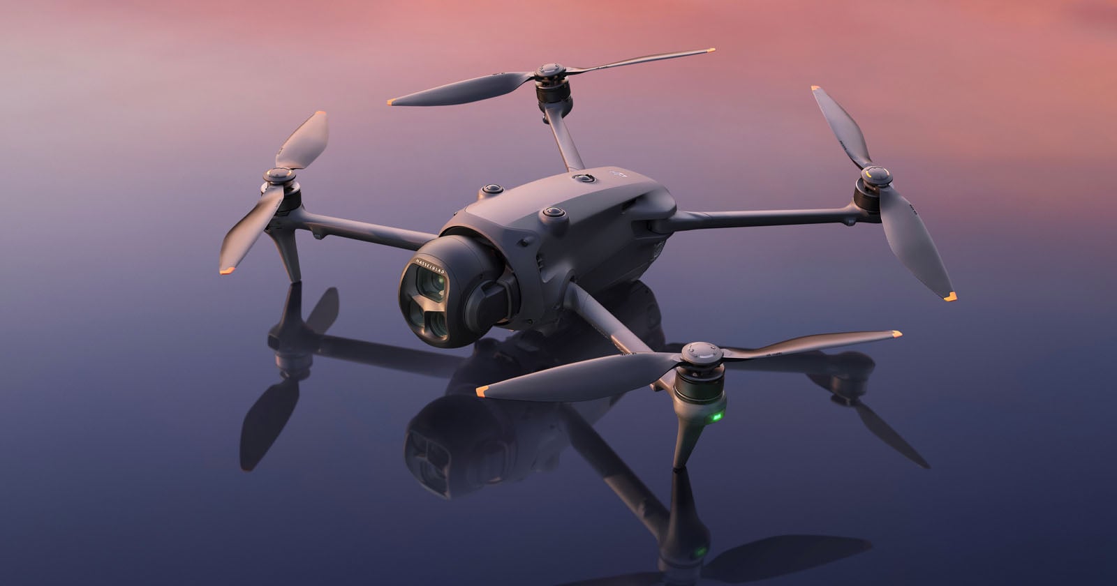
For several summers, I have taught drone photography in Iceland’s highlands under permits issued by the country’s nature conservation agency. I applied on time, followed every condition, and never received a complaint from a ranger, another visitor, or the agency itself.
[Read More]
For several summers, I have taught drone photography in Iceland’s highlands under permits issued by the country’s nature conservation agency. I applied on time, followed every condition, and never received a complaint from a ranger, another visitor, or the agency itself.
The Trump administration’s hesitancy in signing a major drone deal with Ukraine is slowing the U.S. military down in an area where it’s already trying to play catch-up. Even as Ukrainian President Volodymyr Zelensky has urged Washington to make a deal, with talks between the two nations stretching back to at least September, the U.S....
The Trump administration’s hesitancy in signing a major drone deal with Ukraine is slowing the U.S. military down in an area where it’s already trying to play catch-up. Even as Ukrainian President Volodymyr Zelensky has urged Washington to make a deal, with talks between the two nations stretching back to at least September, the U.S....
By Allison Jackson and Joy Chiang
Taiwan’s drone exports are taking off, fuelled by the war in Ukraine, as Taiwanese companies seek a stake in the fast-growing global market for unmanned aerial vehicles.
A bomb-dropping unmanned aerial vehicle (UAV) is displayed at the headquarters of Taiwanese drone manufacturer Thunder Tiger Group in Taichung on April 21, 2026. Photo: I-Hwa Cheng/AFP.
Low-cost drones used for reconnaissance and strikes are in high demand as governments around the wor
Taiwan’s drone exports are taking off, fuelled by the war in Ukraine, as Taiwanese companies seek a stake in the fast-growing global market for unmanned aerial vehicles.
A bomb-dropping unmanned aerial vehicle (UAV) is displayed at the headquarters of Taiwanese drone manufacturer Thunder Tiger Group in Taichung on April 21, 2026. Photo: I-Hwa Cheng/AFP.
Low-cost drones used for reconnaissance and strikes are in high demand as governments around the world boost defence spending in the face of intensifying conflicts.
A relatively new player in the increasingly competitive industry, Taiwan’s pitch is to be an “Asian hub” for the production of UAVs and components free of Chinese materials, or “non-red”.
That means its UAVs can be up to three times more expensive than their Chinese competitors, like the world’s biggest manufacturer DJI, which benefit from their massive scale.
Nevertheless, Taiwanese companies have recorded a surge in sales as Russia’s full-scale invasion of Ukraine, where drones have been used extensively by both sides, drives demand.
China’s export restrictions on drones in recent years have also opened up an opportunity for Taiwanese firms, which have been struggling to secure sufficient sales at home.
“Domestically there’s not enough demand,” said Samara Duerr, a policy analyst at the Research Institute for Democracy, Society and Emerging Technology (DSET), a Taiwan government-backed think tank.
“So it’s reaching internationally to help bring scale and experience so that it has this capacity and knows how to have a surge ability later on.”
Taiwan’s drone exports soared to 181,159 units in the first four months of this year, nearly 20 times higher than the same period of 2025, and more than the entire year, official trade data show.
The vast majority went to the Czech Republic, followed by Poland. DSET believes most units are bought or funded by charitable organisations and donated to Ukraine.
Max Lo, chairman of AeroSoarX, which makes military and dual-use drones, said Taiwanese companies had to look abroad to stay viable.
Although Taiwan is trying to build a domestic drone industry, budget hold-ups in the opposition-controlled parliament mean government orders are not keeping pace.
“If we don’t have the local demand, government support or budget, how can we sustain the production line?” said Lo.
“That’s the reason I visit Ukraine, I visit Poland. I let them know, okay, we have this or that; we have production still available.”
‘Drone shield’
Taiwan is a global powerhouse in AI technology and semiconductor chip manufacturing, and hopes to build on that experience in the drone industry.
A Taiwanese soldier operates an unmanned aerial vehicle or drone during an annual military exercise ahead of the Lunar New Year in Kaohsiung, Taiwan, on January 29, 2026. Photo: Taiwan’s Ministry of National Defense, via X.
The island aims to have a monthly production capacity of 100,000 drones by 2030, compared with its previous target of 15,000 by 2028.
Chiou Chyou-huey, director general of the Industrial Development Administration, said the “vast majority” of Taiwan’s drone exports were non-red, but several industry insiders told AFP that they suspect most of them are not.
Taiwan wants to be able to produce enough drones on its own to repel a potential attack from China, which claims the island is part of its territory, and embed itself into global UAV supply chains, like it has done with chips.
“We call it the drone shield,” said Lo. “That will become another protection (for Taiwan).”
But the government’s plan to procure more than 200,000 Taiwanese-made drones as part of a nearly US$40 billion defence spending proposal has been blocked in parliament, hindering progress.
Taiwanese companies also face challenges breaking into a market already dominated by China — and their drones and components lack battlefield experience.
“Even though it is hard to question Taiwan’s industrial prowess, it is all about this question of practical application,” said Marcin Jerzewski, head of the Taiwan office of the European Values Center for Security Policy.
“Would Taiwanese drones be combat-ready?”
Cut-throat competition
Another issue is that Ukraine, which has become one of the most advanced UAV manufacturing hubs in the world, could stop needing Taiwanese drones once the conflict is over and flood the market with its own units.
A Ukrainian drone crew member handles an unmanned aerial vehicle (UAV). Photo: Ukraine Defence, via Facebook.
Competition is “cut-throat” and growing fast, said Collin Koh, a military expert at the S. Rajaratnam School of International Studies in Singapore.
“Taiwan will have to find its niche,” Koh told AFP.
Where Taiwan can compete against China is in “micro components” such as lithium-ion cells, said Artur Savchii, an analyst at Snake Island Institute, a Ukrainian think tank.
“That’s where Taiwan can replace China and I think this is a big area for cooperation,” Savchii told AFP.
Ultimately every region is striving for “maximum localisation” of supply chains, Yaroslav Azhnyuk, founder of Ukrainian drone company The Fourth Law, said.
Taiwanese drone makers are increasingly partnering with companies abroad, as they carve out a place in the non-red market.
Among them is Thunder Tiger, which has a joint venture to make drone motors in the US state of Ohio.
General manager Gene Su said he sees the biggest opportunities in the United States where concerns over Chinese security threats are driving demand for non-red drones and components.
Thunder Tiger also wants to set up production lines in Europe but countries there are more price sensitive, Su said.
“Once we’re getting bigger, our costs are lower, and then we can compete with the Chinese,” he said.
An independent security assessment conducted by U.S.-based cybersecurity firm OnDefend found that there are no security-related reasons for blocking DJI's products from being imported and sold in the United States.
[Read More]
An independent security assessment conducted by U.S.-based cybersecurity firm OnDefend found that there are no security-related reasons for blocking DJI's products from being imported and sold in the United States.
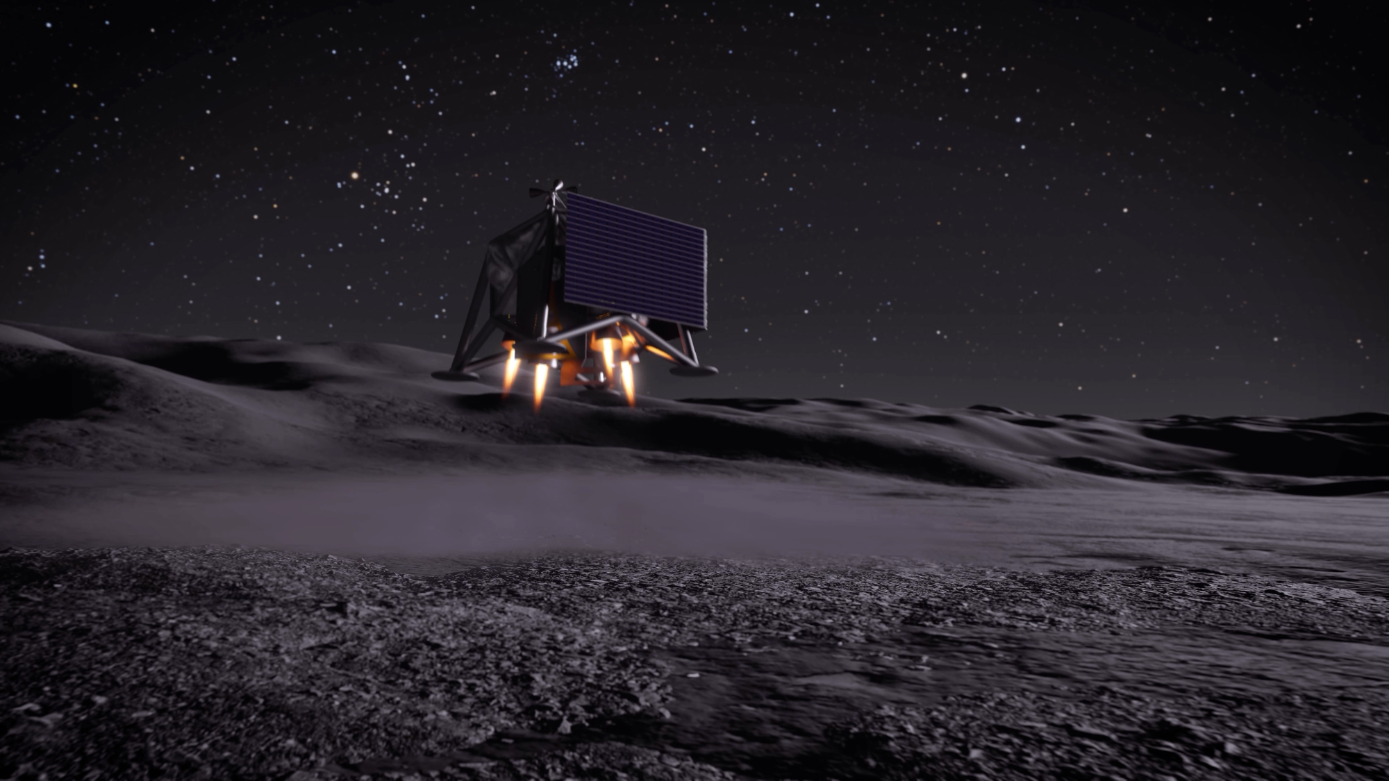
As NASA looks ahead towards Artemis III in mid-2027, the agency is sharing new details on several projects, including a future permanent moon base and a drone mission called MoonFall. The mission will send four drones to survey the surface of the moon’s South Pole to spot potential landing sites for future Artemis astronauts.
According to the update, the Jet Propulsion Laboratory (JPL) in Southern California has been developing the drone design and testing prototype hardware ahead of the sch
As NASA looks ahead towards Artemis III in mid-2027, the agency is sharing new details on several projects, including a future permanent moon base and a drone mission called MoonFall. The mission will send four drones to survey the surface of the moon’s South Pole to spot potential landing sites for future Artemis astronauts.
According to the update, the Jet Propulsion Laboratory (JPL) in Southern California has been developing the drone design and testing prototype hardware ahead of the scheduled 2028 launch. Each drone will land on the moon’s surface and gather high-resolution imagery of the terrain over the course of a single lunar day (up to 14 Earth days). After each drone’s last flight, its survive-the-night payload will continue to work for several months. Payloads that are designed to survive-the-night can endure the sub-zero temperatures of the lunar night, which can get as cold as -208 degrees Fahrenheit.
Each of the four drones should weigh about 550 pounds, and stand at four-feet tall and seven feet in diameter. They will use a Lunar Dashcam imaging system to create maps of the terrain. The drones will also be equipped with a laser retroflector array so that mission control can precisely locate the drones, a neutron spectrometer system to help determine how much (if any) subsurface water is present, and a spectrometer to measure radiation.
Texas-based Firefly Aerospace was selected to build the spacecraft that will transport the drones. Firefly’s Elytra spacecraft will carry the drones for a 45-day transit from the Earth to the moon. After entering lunar orbit, it will deorbit and perform a braking maneuver to send out the drones roughly 31 miles above the lunar South Pole.
No stranger to lunar exploration, Firefly Aerospace’s Blue Ghost lander became the first commercially built lander to reach the lunar surface in March 2025. While on the moon, Blue Ghost delivered 10 NASA instruments designed to gather lunar subsurface data and also snapped some beautiful images of a solar eclipse.
As of now, NASA and 66 other nations have signed the Artemis Accords. While not an international treaty, the Artemis Accords is an agreement for high-level principles of space exploration and provides a basic legal framework for exploring and developing the lunar surface during this century. However, the NASA-led Artemis group is in direct competition with an initiative led by China to explore the lunar South Pole and potentially extract its resources.
Several times a day, a drone carrying high-capacity cameras and flashing red-and-blue lights whirs and rises from the rooftops of police stations across Hong Kong.
They emerge from a box-shaped docking system that slowly unfolds its doors to both sides. Some hover over the city’s billion-dollar villas with private pools and tennis courts; others whizz along streets bustling with people and traffic.
“Police Drone in Operation” banner in Sung Wong Toi, Kowloon, on May 12, 2026. Photo: Kyl
Several times a day, a drone carrying high-capacity cameras and flashing red-and-blue lights whirs and rises from the rooftops of police stations across Hong Kong.
They emerge from a box-shaped docking system that slowly unfolds its doors to both sides. Some hover over the city’s billion-dollar villas with private pools and tennis courts; others whizz along streets bustling with people and traffic.
“Police Drone in Operation” banner in Sung Wong Toi, Kowloon, on May 12, 2026. Photo: Kyle Lam/HKFP.
Hong Kong police have been rapidly expanding their use of surveillance technology and automated drones. They have used drones to hunt down people who overstayed visas or gambled illegally.
According to the police force, these technologies will help deliver high-quality police services and optimise deployment and efficiency. Drones and cameras alike will also likely be combined with the use of artificial intelligence (AI) and facial recognition capabilities.
Drones will substitute some of the police’s foot patrols, and tens of thousands of surveillance cameras will be installed to assist in investigations and arrests.
Since a drone patrol pilot scheme was rolled out in May last year, the technology has helped arrest 54 people, including at least six wanted individuals, according to police. The force did not provide complete data, but at least half of the suspects allegedly committed non-violent crimes.
Hong Kong police officers demonstrate the use of unmanned aerial vehicles to journalists on May 19, 2025, days before the launch of the drone patrol pilot scheme. Photo: Hong Kong Police Force, via Facebook.
In one operation last month that spanned from West Kowloon to Lantau Island, police – with the help of drones – arrested 19 people suspected of immigration infractions and prostitution.
In another instance, police used drones to apprehend a group of eight middle-aged and elderly people who were gambling illegally in a public housing estate in Ma On Shan. Police also fined two drivers spotted crossing over into an oncoming traffic lane on a road to Shek O, using a drone.
Police have not responded to HKFP’s request for more details on how the drones helped during those arrests and investigations.
The increased use of drones is a response to China’s push for a “low-altitude economy,” which can be integrated into daily services ranging from deliveries to law enforcement, said Sky Yeung, chairperson of the DNT FPV Drone Association Hong Kong, China.
Businesses such as delivery companies and government agencies can test drone-use scenarios through a regulatory exemption scheme, and the government is taking steps to prepare for more drones in the air, whether operated commercially or by authorities, Yeung said.
Sky Yeung, chair of the DNT FPV Drone Association Hong Kong, China. Photo: DNT FPV Drone Association Hong Kong, China, via Facebook.
So far, police have not explicitly said anything about using drones for national security purposes, which has been a priority for Hong Kong’s law enforcement in recent years.
However, as an expert told HKFP, the capability is there.
Despite the stated purpose of police technology, once the law allows for an agitator, a national security risk, or a terrorist to be prosecuted, it becomes “malleable,” said Bryce Neary, former executive editor of the Seattle Journal of Technology, Environmental & Innovation Law. The US-based lawyer studied the use of drone and surveillance technology in Hong Kong, China, and the US.
If a government “make[s] a legal argument to do so, then the technology is in place and can be utilised regardless, and as needed essentially, when the government wants to change those terms for their use,” Neary told HKFP on the phone.
Moreover, there are potential privacy issues.
To people on the ground, police drones flying between 60 and 90 metres above ground will be barely noticeable to the naked eye, Yeung said, and their buzzing noise is unlikely to cause a nuisance, given other urban noise.
But nothing escapes the drones flying above us. Police drones, similar to those used in China, can typically “film everything” with “powerful lenses that can zoom in from a great distance, such as seeing what is inside a vehicle,” he said.
Police drones are marked with flashing lights and reflective decals for people to identify them, but these won’t be visible at their usual operating altitude, Yeung said. “Maybe you can see a flashing dot at night, but you wouldn’t notice it.”
Screenshot of a video showing police drone surveillance on Lamma Island. Photo: Hong Kong Police Force, via YouTube.
When asked about privacy concerns by HKFP, the police force said its drone patrols fly over “carefully” planned routes that cover only public areas and do not involve private spaces such as building interiors.
The drones “avoid unnecessarily flying close to individuals or private premises” – unless the situation warrants an investigation, in which case the drones would descend to lower altitudes to collect evidence, police said in a statement.
Video footage with no evidential value will not be kept for more than 31 days, and those obtained as evidence will be classified as such and handled by the investigating unit, according to the police statement.
Over the past two years, Hong Kong authorities have been introducing more surveillance technologies without hiccups at the “patriots only” legislature – and without protest.
A smart lamppost. File photo: GovHK.
This is in stark contrast to the time when angry demonstrators tore down experimental “smart” lampposts during the city’s 2019 protests and unrest. Discontent with shrinking political freedoms, protesters suspected that the lampposts would eventually allow authorities to conduct surveillance by adding facial recognition capabilities to their panoramic cameras.
The government strongly denied such plans at the time, and promised the cameras would be disabled or their resolution reduced to assuage concerns.
However, in a reversal, law enforcement is now considering adding facial recognition technology to its toolkit. Such systems may be connected to police surveillance cameras as soon as this year, police chief Joe Chow said in February. By 2028, police will install a total of 60,000 cameras across Hong Kong.
The goal is to have “as many cameras as possible” and replicate what’s in mainland China, where there is camera coverage “every two steps,” he said during a TV interview.
“Times have changed” compared with when society widely opposed increased surveillance and privacy issues, Chow added.
According to police, drone patrols will be used to combat crimes, identify traffic violations, and monitor traffic flows and crowds.
Hong Kong police officers demonstrate the use of drones to the media during the launch of the second phase of the programme on January 19, 2026. Photo: Hong Kong Police Force.
They can be used to track down suspicious individuals, such as someone who appears evasive when police are nearby, police said at press briefings.
They may also soon be equipped with artificial intelligence, but police have not specified whether the same facial recognition technology used on cameras would be applied to drones.
Present technology from mainland Chinese drone surveillance vendors can identify people, objects, behaviours, and events, according to their product catalogues. They can count and identify various types of vehicles moving on a road, or people in a crowd. They can detect illegally parked cars, smoke, or objects fallen onto power lines. They can spot when protest banners are unfurled.
Yeung pointed out drones’ ability to lock on to a target person and track them automatically as they move – a feature commonly used by police in the US. In short, drones film from above, while police operate on the ground.
During the first phase, which began in May last year, drones were deployed to Heung Yuen Wai, a border area with mainland China, and West Kowloon.
“Police Drone in Operation” banner on Lamma Island on March 24, 2026. Photo: Kyle Lam/HKFP.
They also covered busy downtown districts like Central and suburban residential areas such as Yuen Long and Tsuen Wan.
The police force purchased around 700 drones for HK$25 million during the past financial year, and will purchase another 56 in 2026-27 for HK$4.8 million, the Security Bureau told the legislature.
Other agencies also deployed drones for various purposes, from detecting sites at risk of landslides to patrolling several tourist hotspots during Golden Week holidays.
Last year, investigators from the Food and Environmental Hygiene Department apprehended individuals who illegally slaughtered a goat in a rural area, with the help of drones.
Several residents on Lamma Island said they were not aware of police drone patrols, despite prominent banners announcing their presence near the Yung Shue Wan ferry pier and in villages. They said they welcomed the idea that these patrols could prevent bike theft or burglaries, and expressed no worry about privacy issues.
The island’s resident, who asked to be identified only as Mark, said he believes ultimately it is the presence of police officers that will make a difference in deterring crime, something that drones above his head cannot replace. “What you need is your bobby to be walking and to be visible,” he said.
Neary believes a chilling effect is the intended purpose of police drones, more than the number or severity of crimes they manage to actually solve.
“Regardless if it’s actually effective in terms of what it’s doing, the fear of the fact that you’re being monitored at all times for any of these petty crimes in public or in private, I think, is going to be a big deterrent for you to do so,” he said. “And maybe that’s the point in the first place, right?”
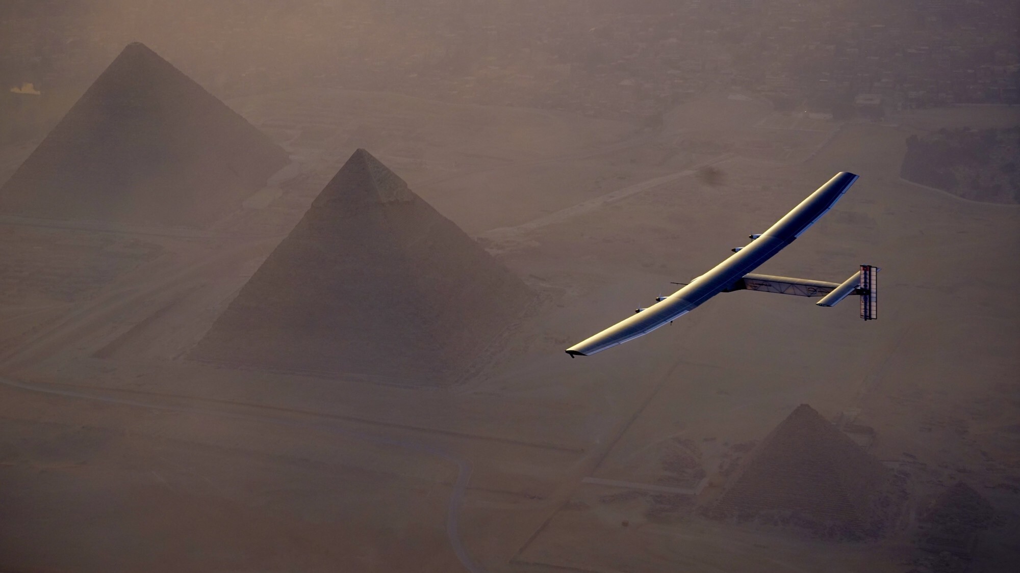
The groundbreaking experimental aircraft known as Solar Impulse 2 has met an untimely end. According to a National Transportation Safety Board report, the completely solar-powered plane crashed into the Gulf of Mexico during an autonomous test flight on May 4. While there were no injuries or fatalities, the wreck of the Solar Impulse marks an unfortunate end for one of the most impressive and inspirational planes in aviation history.
Solar Impulse was first conceptualized in 2003 by Bertrand
The groundbreaking experimental aircraft known as Solar Impulse 2 has met an untimely end. According to a National Transportation Safety Board report, the completely solar-powered plane crashed into the Gulf of Mexico during an autonomous test flight on May 4. While there were no injuries or fatalities, the wreck of the Solar Impulse marks an unfortunate end for one of the most impressive and inspirational planes in aviation history.
Solar Impulsewas first conceptualized in 2003 by Bertrand Piccard, the grandson of Swiss deep sea pioneer Auguste Piccard and the son of Jacque Piccard, the first person to reach the Mariana Trench. Piccard never intended the vehicle for commercial use, but instead envisioned it as a way to raise awareness for sustainable energy by building the first solar-powered plane capable of circumnavigating the globe. The first iteration, Solar Impulse 1, completed its inaugural test flight in 2009 followed by multiple additional trips over the next few years.
Construction on Solar Impulse 2 began in 2011. Even with a 232-foot wingspan that made it wider than a Boeing 747, the completely carbon-fiber frame ensured the plane only weighed about 5,100 lbs, making it about as heavy as a standard SUV. The 130-cubic-foot, nonpressurized cockpit included oxygen reserves and additional environmental equipment to enable a pilot to travel long distances at a maximum altitude of 39,000 feet. According to sUAS News, a total of 17,248 photovoltaic solar cells offered a peak power output of 66 kW to four electric motors and four lithium-ion batteries weighing nearly 1,400 lbs. Basic autopilot technology also allowed its sole occupant to sleep in 20 minute intervals.
Solar Impulse 2 made history in 2016 as the first fixed-wing, entirely solar-powered plane to circumnavigate the Earth. The feat was accomplished over the course of 16.5 months, with Piccard alternating piloting duties with Foundation co-founder André Borschberg and making 17 stops along the route. Solar Impulse 2 cruised at a ground speed between 31 and 62 mph, relying on the slower pace during evening portions of the trip.
In 2019, the Solar Impulse Foundation announced the sale of Solar Impulse 2 to Skydweller Aero for an undisclosed sum. The Spanish–American company’s plans were very different from the plane’s initial purpose. Instead of focusing on its solar capabilities, Skydweller hoped to pursue its military-related surveillance potentials, which included “carrying radar, electronic optics, telecommunications devices, telephone listening, and interception systems.”
After supplying numerous modifications, Solar Impulse 2 completed its first autonomous flight in Spain in 2023. The first entirely uncrewed, autonomous flight took place at Stennis International Airport near Bay St. Louis, Mississippi, the following year. At the time, Skydweller also confirmed its larger goal was to develop and supply a fleet of uncrewed, solar-powered planes capable of nonstop flight at latitudes between Miami (26°N) to Rio de Janeiro (23°S). These near-continuous operations would involve military and commercial contracts, allegedly at a much lower cost than current satellite options. The overhauled flagship aircraft reportedly crashed after losing power while flying over the Gulf of Mexico on May 4.
“We learned through social media about the crash of the Skydweller solar drone,” Piccard and Borschberg wrote in a statement provided to Popular Science. “The Solar Impulse team is saddened by the loss of an important technological flagship.”
Skydweller representatives did not respond to Popular Science at the time of writing. According to the Swiss news outlet SWI, part of Solar Impulse Foundation’s original sales contract with Skydweller stipulated the aircraft would eventually return to Switzerland for installation in the Swiss Museum of Transport in Lucerne.
“Very often when we speak of protection of the environment, it’s boring,” Piccard told Popular Science in 2013. “The first airplane [had] the technology of 2007. The second airplane [had] the technology of tomorrow.”
When Austin Bell first visited Hong Kong in 2017, he was struck by the chromatic vibrancy of its public basketball courts. Coming from the U.S., where these surfaces are often the neutral and uninteresting textures of asphalt and other materials, he was compelled to document the range of vivid color combinations, especially within the context of high-rise neighborhoods and urban infrastructure.
Bell set out to capture 2,549 outdoor basketball courts around Hong Kong—every single one there
When Austin Bell first visited Hong Kong in 2017, he was struck by the chromatic vibrancy of its public basketball courts. Coming from the U.S., where these surfaces are often the neutral and uninteresting textures of asphalt and other materials, he was compelled to document the range of vivid color combinations, especially within the context of high-rise neighborhoods and urban infrastructure.
Bell set out to capture 2,549 outdoor basketball courts around Hong Kong—every single one there is in the region. The resulting series, SHOOTING HOOPS, not only highlights the physical courts but conveys a unique portrait of the region and the spaces where people can mingle. “To me, basketball courts are one of the most interesting subjects for aerial photography because they look so different from above than the ground,” Bell tells Colossal. “Their flatness and geometric design become an almost extraterrestrial tableau—like concrete crop circles.”
For such a densely populated place, Bell’s images are often devoid of people, giving the colorful scenes a subtle ghostly feel. Looking closely, though, you can often see passersby out and about, illustrating the abiding popularity of these urban recreation parks. “One of the newest ones is at a playground called Chung Sing, which is so named for the sound a bell makes, so the designers stylized the surrounding area with audio waveforms,” Bell says.
Bell captured the photos in 2019, trawling Google Maps’ satellite imagery and using his drone to explore spaces between buildings and trees. Over the course of 140 days of shooting during multiple visits, he took more than 40,000 photos. He often photographed from dawn to dusk, and it wasn’t unusual for him to shoot upwards of 100 courts in a day. Once, he meticulously planned a route and captured a mind-boggling 475 courts in a single day.
“The insane became mundane,” Bell says in a statement. “I had become an obsessive completist, unable to rest until I found every court in the city. My obsession was fueled by two desires: to show an unseen perspective of Hong Kong and to fully explore a city that I feel so captivated by.”
Find more on Bell’s Instagram, and purchase the photo book from his webshop.