Evapotranspiration is a critical link between water, energy, and carbon. Scientists need to understand it well to accurately predict weather, droughts, streamflows, and even carbon emissions.
Eddy covariance towers, which measure changes in the atmosphere, are one of the primary ways that scientists measure evapotranspiration in an ecosystem. But these measurements often have a problem with energy imbalance, in which the measured fluxes of sensible heat and latent heat add up to less than they should. (Sensible heat refers to measurable temperature changes occurring via conduction or convection, whereas latent heat refers to water in the atmosphere changing phases.) There’s something missing—up to 30% of the system’s energy—in the math, and that can cause problems for later uses of the measurements, from forecasts to climate policies.
Scientists can adjust evapotranspiration measurements to try to correct for this problem, but a commonly used method to do so assumes that the Bowen ratio, or the ratio between sensible and latent heat, remains constant. However, this assumption may be flawed.
Raghav and Kumar present a new way of tackling this old problem without making assumptions about the Bowen ratio. It’s based on water use efficiency, which is how effectively plants use water to produce biomass.
The method first uses a suite of data from an eddy covariance tower to estimate evapotranspiration and energy balance through time. Then it derives the underlying water use efficiency potential while accounting for the influence of atmospheric dryness. In general, for a given vegetation type, this potential underlying efficiency is considered to be relatively stable over a growing season. The statistically smoothed potential underlying water use efficiencies is then compared to reference values derived during periods when the energy balance is well constrained. The ratio of the two is then used to correct evapotranspiration.
The new method is more consistent and more tied to the physics of plant physiology than current methods when results from each are compared, the authors found.
The new method is appropriate for use with any eddy covariance tower location or dataset because the authors used data from more than 250 towers around the world, in a range of ecosystem and climate types, to build their approach. However, they add, it may be less reliable in environments where evaporation dominates transpiration, such as wetlands. Nevertheless, the authors say, this work marks an important advance in measuring evapotranspiration, with broad implications for water management, agriculture, and adapting to climate extremes and drought. (Water Resources Research, https://doi.org/10.1029/2025WR042766, 2026)
Citation: Dzombak, R. (2026), Improving eddy tower evapotranspiration estimates, Eos, 107, https://doi.org/10.1029/2026EO260163. Published on 20 May 2026.
Atmospheric rivers act like “rivers in the sky,” shuttling intense bands of warm, heavy moisture from lower to higher latitudes. When an atmospheric river encounters cold air or mountainous terrain, the moisture it carries condenses and falls as heavy rain or snow. In Antarctica, the arrival of an atmospheric river can help build surface ice mass. Much of Antarctica is very dry; an atmospheric river can bring the moisture needed to potentially offset some ice loss.
Antarctica’s varied topography and dry conditions have made detecting atmospheric rivers over the continent challenging. Previous efforts to do so have suggested that atmospheric rivers contribute up to 30% of Antarctica’s total annual precipitation, but these methods may not be capturing the full picture of atmospheric river activity.
Takahashi et al. developed a new 3D atmospheric river detection algorithm to better capture how atmospheric rivers affect Antarctica’s complex terrain. Previous methods have mostly been 2D, meaning they do not accurately account for the vertical variations within an atmospheric river.
To evaluate the algorithm, the researchers applied it to two datasets: (1) daily snowfall totals measured during the 44th Japanese Antarctic Research Expedition (JARE44) at Dome Fuji from February 2003 to January 2004 and (2) the ERA5 (European Centre for Medium-Range Weather Forecasts atmospheric reanalysis) dataset of daily weather patterns and conditions in Antarctica from 1979 to 2023.
The results of the study’s new algorithm showed 16 significant snowfall events during the JARE44 expedition, all of which were not detected by the older 2D method. The new 3D method identified 17 days of atmospheric river activity, which corresponded with 10 heavy snowfall events and accounted for approximately 40% of the total precipitation. Between 1979 and 2023, atmospheric rivers occurred about 10% of the time yet contributed 30%–60% of total precipitation in the Antarctic interior.
The 3D method in the new study suggests that atmospheric river events contribute a greater proportion of total snowfall than previously thought—between 30% and 90%, depending on the Antarctic region. The researchers also suggest that long-term changes in Antarctic snowfall are closely linked with the changes in atmospheric river activity. This connection is especially apparent in East Antarctica, where the link between snowfall increases and atmospheric rivers had not yet been clearly identified in previous studies. (Geophysical Research Letters, https://doi.org/10.1029/2025GL120986, 2026)
When we think of terms like “flowing” or “fluid,” we could be referring to the nature of water, but we can also just as easily apply these concepts to our understanding of art and craft. Fabrics “pool” and different mediums converge. The nature of creativity is often referred to in terms of an “ebb and flow.” Ecologically speaking, bodies of water are metaphorically woven into the fabric of our planet. Rivers and lakes sustain an abundance of life, shape cultures, and course through history. Amid the ongoing climate crisis, how do artists express concerns about water and the environment?
Water | Craft, a group exhibition at the Minnesota Marine Art Museum, dives into this question. The museum itself is situated on the banks of the Mississippi River and often directly engages with its expansive biological and cultural reach. Works by seven artists, whose practices incorporate weaving, pottery, basketry, glass, and textile arts, directly interface with contemporary issues of water access and cultural preservation amid climate change.
Sarah Sense, “Land, Lines, Blood, Memory 7” (detail) (2026), archival inkjet prints on Hahnemuhle bamboo paper and Hahnemuhle rice paper, wax, Arches watercolour paper, cotton thread, and artist tape
Colossal readers may be familiar with the mixed-media pieces of Tali Weinberg and Nicole McLaughlin, both of whom combine quantities of colorful thread with other materials in meditations on interconnectivity and multi-disciplinarity. Weinberg translates ecological data into tendril-like installations and abstract weavings, such as a series of three pieces from her Climate Datascapes series that visualize information about silt in the Upper Mississippi River. McLaughlin’s dramatically fringed ceramic platters reference Pre-Columbian cultures and the continuum of human history and time.
Water | Craft also includes works by Rowland Ricketts, Sarah Sense, Therman Statom, Kelly Church, and Tanya Aguiñiga. The latter is known for her intricately knotted wall works containing terracotta forms, which cascade gently to the floor. And Ricketts’ large-scale installation, “Bow,” comprises strands of indigo-dyed linen that suspend within a large gallery space, creating the effect of a current or perhaps the silhouette of a boat.
“Just as water flows through bodies, landscapes, and cultural histories, craft knowledge is passed between generations, carrying technical skills alongside cultural values,” the museum says. “The artists in Water | Craft employ traditional methods not as nostalgic gestures, but as living practices that continue to evolve in response to environmental change.”
Water | Craft continues through December 27 in Winona.
Tanya Aguiñiga, “Internal Body I” (2023), fiber, terracotta, and mixed media. Images courtesy of Volume GalleryTanya Aguiñiga, “Internal Body I” (detail). Image courtesy of Volume GalleryTherman Statom, “Pesca de la Noche” (2015), glass, mixed-media. Photo by Bailey BoltonTali Weinberg, “Silt Studies: Upper Mississippi River Basin” (2021), from the ‘Climate Datascapes’ series, woven fiber, plant-derived dyes, medical tubing, and fishing line. Photo by Bailey BoltonRowland Ricketts, “Bow” (MMAM installation view) (2023), indigo-dyed linen. Photo by Bailey BoltonNicole McLaughlin, “Confluencia (Confluence)” (detail)
Scientists agree that to have a chance of keeping the world’s warming below the Paris Agreement limit of 1.5°C (2.7°F), humanity needs most oil, gas, and coal to remain in the ground. This “unburnable” or “unextractable” carbon would not contribute to global carbon emissions.
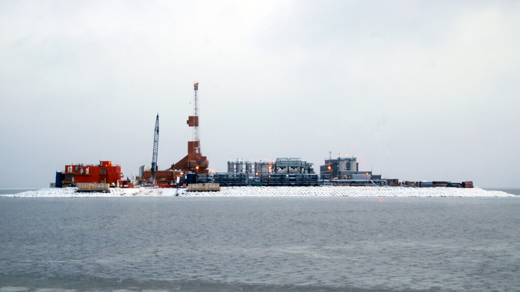
But where, exactly, should we prioritize shutting down or banning fossil fuel activities? A new study published in PLoS One provides an answer for the Arctic with an atlas showing where oil and gas activities overlap with vulnerable ecosystems, important wildlife species, and Indigenous land.
“We’re investigating the idea of unburnable carbon with a geographical perspective,” said Daniele Codato, a geographer at the Università de Padova in Italy and lead author of the new study. “We focus on where to keep oil and gas underground.”
The atlas is meant to help decisionmakers prioritize areas where it is essential to avoid opening new frontiers or where current oil and gas extraction should be halted because of social, cultural, ecological, or climate justice criteria, he said.
Overlaps, Mapped
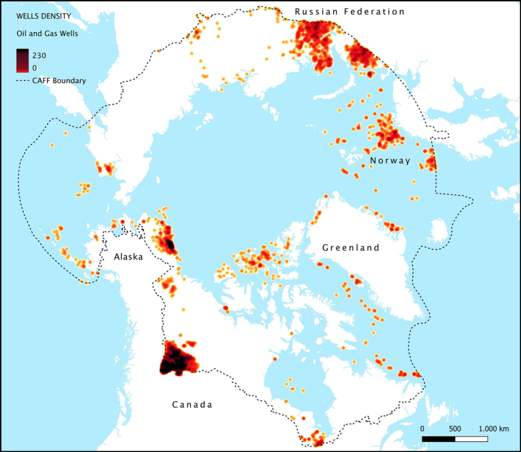
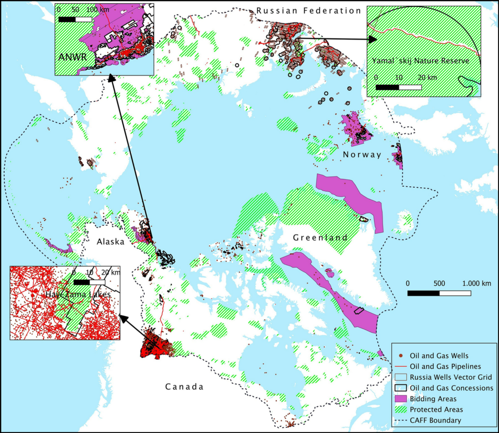
Codato and a team of researchers created their Arctic atlas with dozens of public datasets from five Arctic polities known to have oil and gas activities (Alaska (United States), Canada, Greenland (Denmark), Norway, and Russia). Though various geographic definitions of the Arctic exist, the team chose a boundary used to evaluate wildlife and conservation by the Conservation of Arctic Flora and Fauna (the biodiversity working group of the Arctic Council, an intergovernmental organization focused on Arctic governance) to include the largest possible portion of vulnerable ecosystems.
The resulting maps revealed more than 512,000 square kilometers—an area about the size of Spain—of Arctic territory with existing or planned fossil fuel activities, including leases, areas under bid, exploration licenses, and infrastructure. Within those areas, the researchers counted 44,539 active wells and nearly 40,000 kilometers (about 25,000 miles) of pipelines.
Oil and gas wells in the Arctic are highly concentrated in northwestern Canada, northern Alaska, and northern Russia. The CAFF boundary identifies the Arctic region as defined by the Conservation of Arctic Flora and Fauna (the biodiversity working group of the Arctic Council). Click image for larger version. Credit: Codato et al., 2026, https://doi.org/10.1371/journal.pone.0345775
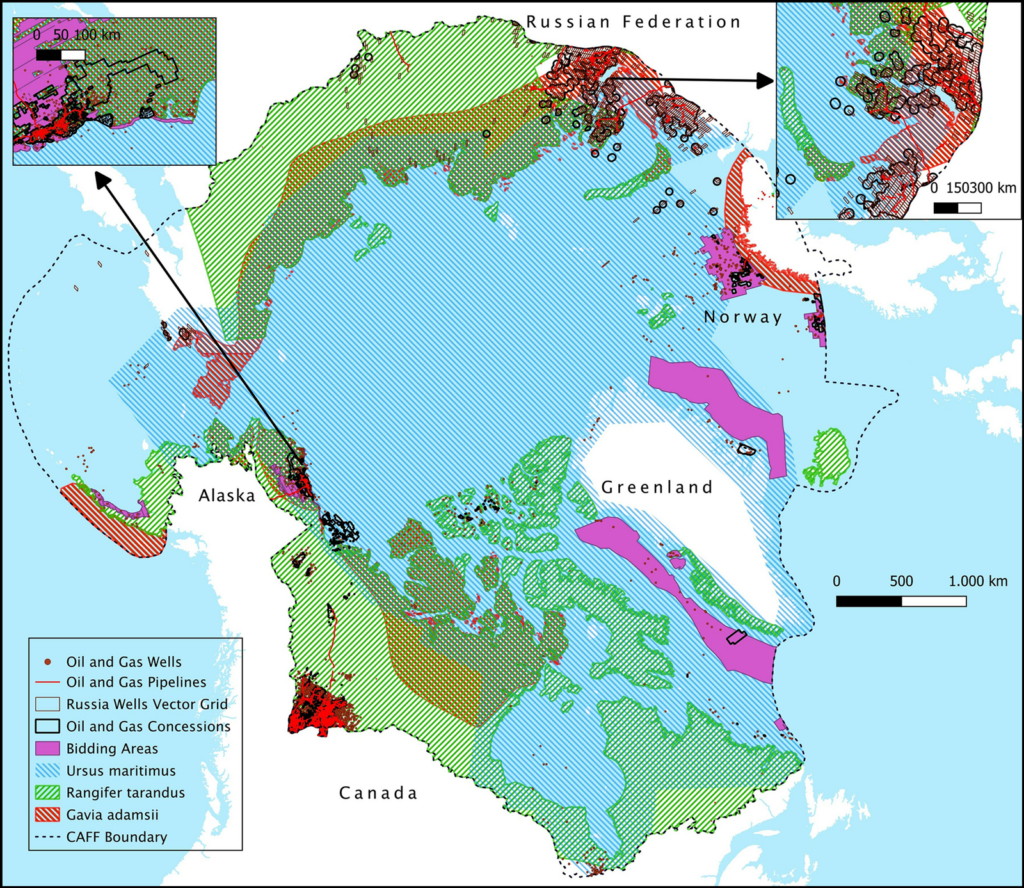
Next, the researchers determined how oil and gas activities overlapped with protected areas defined by the International Union for Conservation of Nature and conservation priority areas defined by three other nongovernmental organizations. Fossil fuel activities threaten wildlife by altering habitats, disrupting migratory routes, and releasing pollutants.
Of the area containing oil and gas activities, more than 7% overlapped with ecologically protected areas, and more than 13% overlapped with the ranges of all of the three key Arctic species considered in the study: polar bears, yellow-billed loons, and caribou. The highest concentrations of oil and gas activities were in the Yamal Peninsula of Russia, northwestern Canada, and the North Slope of Alaska, all home to fragile ecosystems.
Seven percent of Arctic fossil fuel extraction areas mapped by the research team overlapped with ecologically protected areas. In some cases, such as in the Yamal`skij Nature Reserve in Russia (top right), protected area borders have been cut or delimited to avoid overlapping with protected area boundaries, possibly indicating that protected areas have been downsized or redesigned to accommodate fossil fuel infrastructure. ANWR = Arctic National Wildlife Refuge. Click image for larger version. Credit: Codato et al., 2026, https://doi.org/10.1371/journal.pone.0345775
Mapping revealed that 87.21% of leases in Alaska and more than 13% of total Arctic concessions for fossil fuel activities overlapped with the ranges of all three of the key Arctic species considered in the study (polar bears (Ursus maritimus), caribou (Rangifer tarandus), and yellow-billed loons (Gavia adamsii)). Click image for larger version. Credit: Codato et al., 2026, https://doi.org/10.1371/journal.pone.0345775
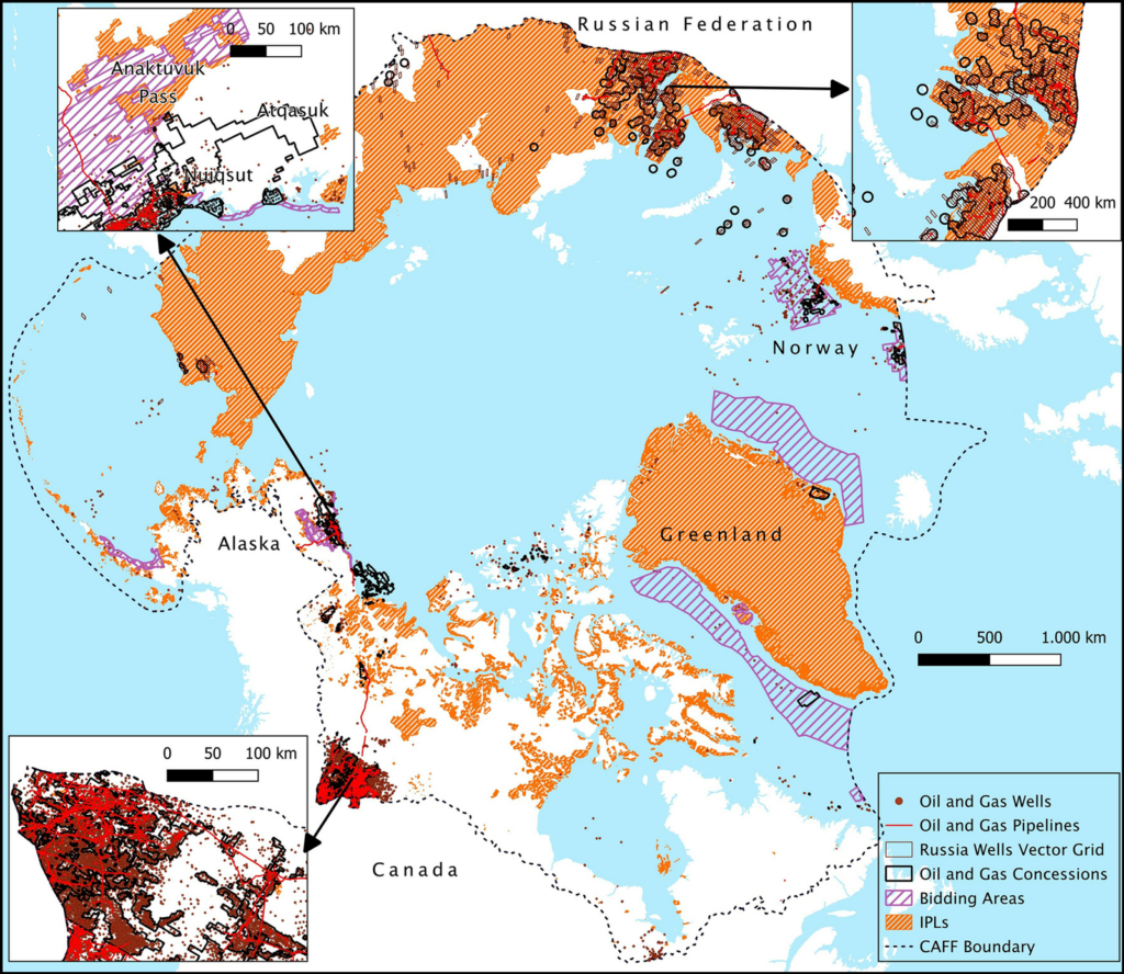
The researchers also discovered that 73% of land with oil and gas activities overlapped with Indigenous Peoples’ lands, defined in the study as lands where Indigenous communities maintain significant influence over land management. Fossil fuel activities can threaten Indigenous communities’ health and ways of life, though the authors note that overlaps between Indigenous Peoples’ lands and fossil fuel activities do not necessarily indicate an opposition between the two.
Oil and gas concessions cover more than 4% of Indigenous Peoples’ lands (IPLs) in the Arctic. Click image for larger version. Credit: Codato et al., 2026, https://doi.org/10.1371/journal.pone.0345775
“It’s a really interesting idea to create an atlas of unburnable carbon and try to make visible where tensions might occur between Indigenous land, ecosystems, [and fossil fuel activities],” said Mariel Kieval, a researcher at the Arctic Institute, a nonprofit research organization. The overlaps noted in the atlas are an “initial indicator” providing opportunities for further research that zooms in on specific areas, she said.
Kieval also said the atlas could be helpful for local communities trying to identify where extraction activities are occurring nearby.
Policy Paradigm
The atlas’s effort to express the urgency of action to the public and policymakers is useful, said Paul Ekins, an economist at University College London who was part of the team that coined the term “unburnable carbon.” “Any way in which atlases or discussions or slogans can up the political ante so that politicians become braver in seeking to address this issue is to be welcomed.”
In particular, Codato hopes the atlas will fuel a “paradigm shift” in global policy that would ultimately ban the proliferation of fossil fuel activities in the Arctic.
The need for an intergovernmental ban on fossil fuel activities is evidenced by the Arctic National Wildlife Refuge in Alaska, Codato said: The refuge received temporary protections against drilling under the Biden administration, but the Trump administration plans to open the refuge for oil and gas leases this summer. “We need something stronger” to avoid such administration-by-administration changes in Arctic protections, he said.
“If we don’t start to ban fossil fuels in the Arctic now, it could become another sacrifice zone.”
Such a paradigm shift will be more important than ever as warming in the Arctic provides new access to resources and opportunities for trade that may accelerate ecological and cultural disruptions. “If we don’t start to ban fossil fuels in the Arctic now, it could become another sacrifice zone,” like some parts of the Amazon rainforest, Codato said.
Policy actions have fallen far behind the science, Ekins said. “There should have been an agreement not to exploit fossil fuels in the Arctic well before the ice had melted to a sufficient extent to make that a practical possibility.”
In 2023, the research team published a similar atlas identifying unburnable carbon in the Ecuadorian Amazon and plans to continue to expand their atlas to include the rest of the world. The team is currently working on projects that cover Brazil, Italy, Nigeria, and the United Kingdom.
Citation: van Deelen, G. (2026), This Arctic atlas shows where oil and gas activities overlap with wildlife and Indigenous communities, Eos, 107, https://doi.org/10.1029/2026EO260139. Published on 7 May 2026.
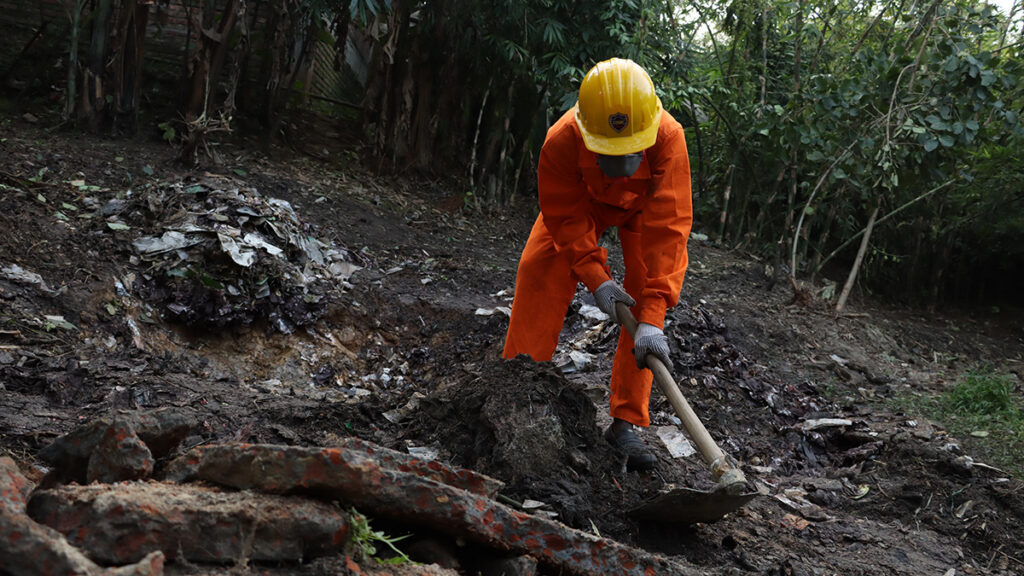
Lead-acid batteries are omnipresent. An integral part of most electric vehicles and all conventional vehicles globally, they also serve as backup energy storage systems in developing countries. But if lead-acid batteries are recycled in smelting units without adequate pollution control measures, they can cause elevated lead pollution that persists in local soils for thousands of years. However, because recycling sites with pollution control measures cost millions of dollars, most efforts are informal and unregulated.
In a recent study, researchers reported that scraping lead-contaminated soil in the vicinity of an abandoned recycling site for used lead-acid batteries and treating it with phosphate was linked to a 22% reduction in the blood lead levels (BLLs) of children who were living close to that site in a Bangladeshi town. The research was published in the International Journal of Hygiene and Environmental Health.
“Informal battery recycling is rampant in Bangladesh.”
“Informal battery recycling is rampant in Bangladesh,” said study coauthor Mahbubur Rahman, an environmental health scientist at the International Centre for Diarrhoeal Disease Research, Bangladesh. “Used lead-acid batteries are broken up and smelted in close proximity to residential and agricultural areas, which exposes those communities to lead emissions that contaminate their soil and water sources.”
Rahman and colleagues analyzed the BLLs of 130 children living close to two recycling sites for used lead-acid batteries (ULAB) in the Tangail District of Bangladesh that were abandoned in early 2019. They also assessed the BLLs of 37 children who did not live anywhere near ULAB recycling sites. The researchers then carried out soil remediation efforts at one of the ULAB sites but not the other. Prior to the work, the team members held informational sessions for the community about the dangers of lead pollution so locals could provide informed consent to participate.
The team observed that following remediation efforts, the lead content of the soil in and around the former battery recycling site decreased from more than 20,000 parts per million to less than 400 parts per million, which was considered acceptable by the U.S. EPA when the study was conducted, from 2022 to 2023. (The EPA reduced the limit to 200 parts per million in 2024.)
The researchers collected and cleaned up soil from children’s play areas, roadsides, and courtyards of 68 households that belonged to the intervention group. A year after the lead-contaminated soil was cleaned up, the 89 children from those households had the most significant decreases in their BLLs: from 90.1 to 70.4 micrograms per liter, a decrease of more than 21%.
“We know for sure that the areas close to abandoned ULAB recycling sites are as contaminated as areas around abandoned lead mines.”
The children in the group who lived close to the second abandoned ULAB recycling site, where soil remediation was not conducted, experienced only about an 8.4% decrease in their BLLs, from 88.5 to 81.1 micrograms per liter. The reduction in the control group’s BLLs could be attributed to a government initiative focused on reducing lead levels in turmeric, which was happening over the same time period as the study, Rahman said.
Anne Riederer, an environmental health scientist at the University of Washington who was not involved in the new study, said the dangers of lead exposure from ULAB recycling sites are well documented.
“We know for sure that the areas close to abandoned ULAB recycling sites are as contaminated as areas around abandoned lead mines. This study fits with the bigger picture of what we have learned to date about cleaning up contaminated sites and how that could improve children’s health,” she said.
A Widespread Issue
Similar studies conducted in Brazil and Bangladesh reported 46% and 35% reductions, respectively, in children’s BLLs following soil remediation initiatives around ULAB recycling sites.
Despite those drastic improvements, the children’s BLLs were still far above the World Health Organization’s threshold of 50 micrograms per liter. “This could mean there are other sources of lead exposure, like paints and cookware items,” said Rahman. “Or the persistently high BLLs could be because of chronic and long-term lead exposure, due to which lead gets deposited deep into the bones for several decades, even if [people] move away from toxic sites.”
Rahman explained that while soil remediation is an effective mitigation measure for lowering childhood lead exposure, it is also labor-intensive and expensive. Though the team identified hundreds of toxic sites borne from informal ULAB recycling, it wasn’t possible for them to remediate the soil at every site.
“The reason why this issue is so widespread is [that] informal recycling is cheap,” he said. “That makes the formal sector reluctant to invest in costly pollution control measures.”
—Anuradha Varanasi, Science Writer
Citation: Varanasi, A. (2026), Cleanup of battery recycling sites may lower childhood lead exposure, Eos, 107, https://doi.org/10.1029/2026EO260120. Published on 15 April 2026.
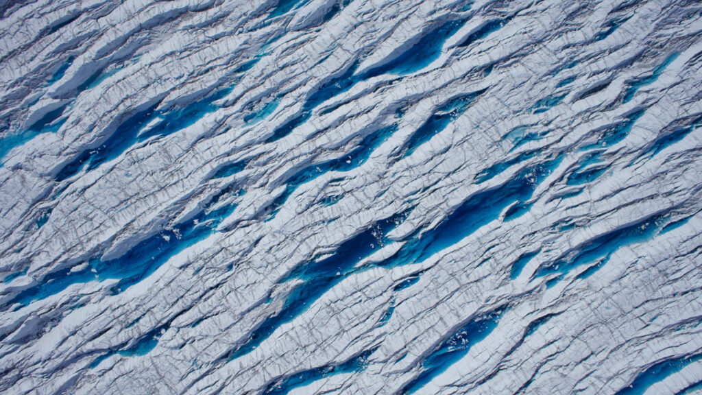
As meltwater drains through and beneath a glacier, it can alter how the ice flows and whether it breaks apart. Meltwater can also cause feedbacks that lead to more ice loss. Understanding when and how glacial meltwater drains is therefore critical to predicting how fast glaciers will lose ice and how that loss will affect sea level.
Chudleyet al. modeled how the rate of water flowing into a glacier relates to seasonal changes in the forces that squeeze and stretch ice—forces caused by gravity pulling the glacier downhill, by the ice sliding over subglacial water, and by how portions of the ice interact with the ocean.
The researchers focused on the Sermeq Kujalleq glacier (also known as Store Gletsjer or Store Glacier) in Greenland. In spring, meltwater can fill cracks, or crevasses, that run through the surface of this glacier. These crevasses sometimes go on to drain as the year progresses.
The researchers used satellite imagery from the Sentinel-2 mission to see how much water was present in crevasses between 2016 and 2022, focusing especially on 2019, when the Sentinel-2 satellites provided the best coverage of the glacier. They fed those data into a convolutional neural network to map water cover through the season and looked for a relationship between the mechanical forces acting on the ice and the formation and drainage of crevasse ponds.
The researchers found that the mechanical forces acting on ice are the dominant factor in determining when crevasse meltwater drains into a glacier. When seasonal changes cause ice to stretch, crevasses can drain suddenly, releasing the water they held.
The Greenland Ice Sheet sheds trillions of gallons of water each year, and knowing when to expect that water to drain through the ice sheet is key to understanding processes such as how the glacier slides across the bed and when meltwater emerges in the ocean. The study’s results likely also shed light on dynamic processes in other glaciers and ice sheets, the authors say, and should help inform representations of ice behavior in numerical models. (AGU Advances, https://doi.org/10.1029/2025AV002150, 2026)
Citation: Sidik, S. M. (2026), Stretching and squeezing release glacial meltwater, Eos, 107, https://doi.org/10.1029/2026EO260152. Published on 26 May 2026.
A species of chimaera — aka a ghost shark — is among the 1,121 species scientists say they recently discovered as part of a marine exploration mission called Ocean Census. | The Nippon Foundation-Nekton Ocean Census/CSIRO
It lives in a glass castle deep under the sea.
It’s not a character from The Little Mermaid but a very real, very mysterious marine worm. Known as Dalhousiella yabukii, the worm resides inside a glass sea sponge — a simple marine animal that forms a glass-like skeleton — in the cold, dark waters off the coast of Japan. And it’s just one of a massive trove of marine animal species that scientists say they recently discovered.
This week, the Ocean Census — a project that has set out to accelerate the discovery of sea life — announced that it has found 1,121 previously unknown ocean species since last April. That marks a massive jump in the number of newly discovered marine species in a single year, according to Oliver Steeds, director of the Ocean Census, a joint mission of the UK-based nonprofit Nekton and Japan’s largest philanthropic organization, the Nippon Foundation. Some of the other newly found creatures include fish, rays, sponges, and soft corals (you can see more of them below).
Though it may seem that Earth is already largely explored, the vast majority of animal species on Earth — perhaps as many as 90 percent of them — remain undescribed. “This is really a planetary blindspot,” said Steeds, who’s also the founder and chief executive of Nekton.
The Ocean Census, which launched three years ago, is trying to close the gap in the marine realm by exploring remote ocean regions with the help of high-tech submersibles and taxonomists. And to that end, this large batch of species is an important step forward — with one major caveat.
Meet some of the weird creatures they found
While the search for life beyond Earth has been a magnet for public attention, missions like the Ocean Census reveal that there is a lot we still don’t know about life on our home planet — much of which looks pretty darn alien.
Most critters that the expeditions revealed are pretty small, like this striking ribbon worm. Found in the waters near Timor-Leste in Southeast Asia, the worm’s bright colors may be a signal to predators that it produces defensive toxins, according to a press release announcing the new findings. Such toxins may be useful in drug development; scientists have previously investigated chemicals produced by similar worms to treat cognitive disorders, such as Alzheimer’s disease.
Remarkably, the discovery effort also uncovered larger animals, which have likely managed to evade detection because they live at such great depths and in less-explored regions.
The most charismatic among them is, perhaps, this new species of “ghost shark” that scientists found off the coast of Australia. Though distantly related to sharks and rays, ghost sharks are not actually sharks at all but chimaeras, a deep-sea fish with a skeleton made of cartilage instead of bone.
In the same region, scientists also found an unknown species of ray…
…and an unfamiliar example of what’s known as a catshark. They’re bottom dwellers with slender bodies, and some of them apparently have a feline appearance (I’m not seeing it in this particular fish, which was found deep underwater in Australia.)
Then there are animals that don’t look like animals at all. Like this unfamiliar sea sponge found in the South Atlantic, not far from Antarctica. Belonging to a group of animals known as the ping-pong ball sponges (for obvious reasons), this animal is carnivorous and uses those balls — which are covered in tiny Velcro-like hooks — to entrap unsuspecting prey drifting by, such as small crustaceans.
Also in the South Atlantic, scientists found an unknown variety of “sea pen,” a kind of soft coral, more than 2,600 feet below the surface. It’s not one individual animal but a colony of thousands of genetically identical polyps, soft-bodied creatures with tentacles.
(You can see more of the alien-like species found through the Ocean Census here.)
Are these species actually new?
The announcement from the Ocean Census says that scientists “discovered” more than 1,100 “new” species in a single year. Those words must be taken with a grain of salt.
Proving that a species is new to science is difficult. It typically requires that taxonomists comb through existing museum collections and academic literature to demonstrate that, based on anatomical, genetic, or other traits, what they have has not been documented before. They can then submit their evidence for peer review and publication — the typical process through which a species is formally described and officially named, thus becoming a new species.
Many of the discoveries announced by the Ocean Census, however, have not yet gone through that level of due diligence and have not been formally described, according to Greg Rouse, a marine taxonomist at the Scripps Institution of Oceanography. That means it’s not clear that all of those species are, in fact, new to science.
As the Ocean Census points out in its announcement, the time between collecting a species and formally describing it as new takes about 13 years on average. That means some animals could go extinct before they’re even described in the scientific literature, the group says. “But that 13 years is there for a reason,” said Rouse, who isn’t involved in the Ocean Census project.
Formally describing and naming a species not only confirms that it’s new, but it also makes the species easier to study and conserve, such as through laws that protect named endangered species.
“The formal description process carries out the actual work to confirm novelty and provides the ‘passport’ for that new species — its official record,” said Tammy Horton, a research scientist at the UK’s National Oceanography Centre. “Without this, the formally recognized name, the species effectively does not exist for science, and therefore also for policy — unnamed species cannot be protected.”
Karen Osborn, a taxonomist at the Smithsonian National Museum of Natural History, similarly expressed skepticism about the announcement. Discovery alone is not enough, said Osborn, who’s not directly involved in the Ocean Census. “I don’t feel like saying, ‘Oh, look, we discovered something new’ should be given the status of something being described — until you’ve actually done the work to show that it’s something unique,” Osborn said. But, she said, “it’s a step in the right direction.”
A significant number of species uncovered by the Ocean Census and its partners are, in fact, already described in the scientific literature, Steeds, of Ocean Census, told me. He didn’t know how many. “It is not for us to do that,” he said of formally describing the species. (In many cases, taxonomists involved in the discoveries will later put in the time to formally describe them.) “Our job is discovery and to accelerate discovery,” Steeds said, which is the first step toward the formal new species description.
Horton, who’s also not directly affiliated with the Ocean Census, emphasized this point, too: “It is important to recognise that the identification or ‘discovery’ process is a fundamental part of the pipeline towards the ultimate goal of description of a species as new to science,” she told Vox. “You cannot have one without the other.”
Might some of these species not, in fact, be new? “It is something that we all need to be aware of,” Steeds told me. “Species discovery, species description are always a hypothesis — that’s the nature of it. And things do change.” (Horton suspects it’s not very common for taxonomists to believe something is new to science and later find out that it’s an individual of an already described species.)
If there’s one thing that the Ocean Census’s findings are helping reveal with absolute certainty, it’s that so much of the planet’s biodiversity remains a mystery. That’s exciting and hopeful.
“I would love people to know how much we don’t know about how much is out there,” Osborn said. “We’ve barely scratched the surface on understanding our world.”
The World Cup kicked off on Thursday as South Africa squared off against Mexico, one of this year's host countries. Several American cities hosting these opening matches will be sweltering this weekend, making stadiums feel more like a sauna than a playing field. Climate Central's Ben Tracy shows us how extreme heat is changing the game in our warming world. It's for our series, Tipping Point.
A view of the Moose Lake entry point to the Boundary Waters, a federally protected area in northeastern Minnesota. | Anthony Souffle/The Minnesota Star Tribune via Getty Images
There’s no such thing as a truly pristine landscape — humans have, over millennia, shaped every environment on Earth — but the Boundary Waters wilderness of northeastern Minnesota comes pretty darn close.
Stretching across more than a million acres near the Canadian border, about four hours north of Minneapolis, the Boundary Waters is a messy patchwork of lakes, streams, and islands with hardly any human infrastructure. At dawn, loons slice through the placid water and, come nightfall, bright stars splatter the dark sky.
The natural beauty of the Boundary Waters — a federally protected wilderness area — is a magnet for tourism, an enormous economic engine for the region. The Boundary Waters is not only the most visited wilderness area in the country, but also home to federally threatened species like the gray wolf and the Canada lynx.
It’s for this reason that many environmental advocates are worried about a proposed mine just outside the southern edge of the Boundary Waters. A company called Twin Metals Minnesota — a subsidiary of the Chilean copper giant Antofagasta — wants to mine copper, nickel, and other metals deep underneath the wet Earth. And earlier this year, Congress and President Donald Trump removed a major obstacle that had stood in its way: The House and Senate overturned a Biden-era mining ban in the region, allowing Twin Metals to revive its mining push within the watershed.
Environmental advocates warn that a metals mine could be disastrous for the unique Boundary Waters ecosystem. Though mining and other extractive industries are prohibited inside the Boundary Waters, the region’s hydrology is such that any pollution from the mine would likely flow into the wilderness area, potentially harming its forests, wildlife, and the livelihoods of Native Americans, who use the area to fish, hunt, and harvest wild rice.
And the thing about mines, critics say, is that they nearly always pollute.
“It’s not a matter of if this mine is going to pollute, it’s a matter of when,” said Ingrid Lyons, executive director of the advocacy group Northeastern Minnesotans for Wilderness, which leads a campaign called Save the Boundary Waters.
Twin Metals says these concerns are largely rooted in misinformation and it can mine in an environmentally safe way. Like other mining projects seeking approval, this one would have to meet both federal and state environmental safeguards before opening — and Minnesota’s are particularly strong. The company also defends the project on a different kind of environmental grounds, pointing out that the world needs more metals like copper, nickel, and cobalt to build clean energy technologies, such as batteries for electric cars — which is true. If those metals don’t come from Minnesota, they might just come from other countries with less rigorous environmental regulations.
The upshot is that what may sound like a simple narrative — environmentalists versus a mine — highlights a more complex reality. Mining isn’t inherently bad; yet, it always comes with trade-offs. The question facing Minnesota, where there’s still a path to ban copper mining near the Boundary Waters, is whether the costs will be worth it.
The proposed Twin Metals mine, briefly explained
While the Boundary Waters is famous for its surface lakes, streams, and forests, it sits atop one of the world’s largest unexploited deposits of copper and nickel, known as the Duluth Complex. It’s these materials that Twin Metals is after.
According to Twin Metals, miners would excavate and crush ore — metal-rich rock — as far as 4,500 feet down and, then, send it up to the surface. There, they’d remove compounds containing copper, nickel, and other minerals, which they’d ship elsewhere to be refined into usable metals. The company said it would put some of the leftover rock, known as tailings, back underground. The rest would go into a pile on land nearby.
Twin Metals has been pursuing this planned mine for more than a decade, and it said it’s plowed some $650 million into it. In recent years, however, the project has hit a number of roadblocks.
In 2022, the Biden administration canceled Twin Metals’s two mineral leases (which had given the company a right to explore and mine in certain areas but not approval for specific projects). And, in early 2023, the administration put a 20-year pause on approving new leases near the Boundary Waters in the region where Twin Metals had been planning to mine. “With an eye toward protecting this special place for future generations, I have made this decision using the best-available science and extensive public input,” then-Interior Secretary Deb Haaland said in a statement announcing the decision.
It was that temporary ban that was recently overturned. Congressional Republicans — led by Minnesota Rep. Pete Stauber — found what is essentially a loophole, through an obscure law called the Congressional Review Act, to not only undo the ban but also to prevent future administrations from issuing similar protections without an act of Congress.
This move does not reinstate Twin Metals’s two federal mining leases. The company had previously challenged the lease cancellations, back in 2022, and it’s still waiting on a decision from the courts. Congress is also considering a bill that would re-issue those leases to Twin Metals. Should the company acquire leases to mine, the project would then be subject to a review by federal and state agencies, both of which have the authority to block the project. Even with federal approval, the Minnesota Department of Natural Resources, a state agency, could decide not to grant the company a permit to mine.
Will this mine pollute the wilderness?
Twin Metals says, perhaps unsurprisingly, that its mine will be exceptionally clean. The mine would be underground, the company said, so it would have only a small surface footprint, including a processing facility about the size of a Super Target.
The company also claims that its modern approach won’t produce a water pollutant — common among mines — called acid rock drainage. Metal in the ore is bound to compounds called sulfides. When sulfides react with air and water, they can produce sulfuric acid, which is toxic to plants and animals and can leach heavy metals, such as arsenic, out of rock.
“Twin Metals Minnesota is focused on responsibly developing the minerals in the Duluth Complex,” Kathy Graul, a spokesperson for Twin Metals, told Vox. “Any proposed project in this region, including Twin Metals, must undergo a yearslong, multi-agency regulatory review before earning permits to begin construction of a mine.”
Environmental advocates and the academic researchers I spoke to are not convinced.
“If the mine is built, there would be runoff, there would be mine discharge, and that discharge would contain sulfate,” said Lyons, of Northeastern Minnesotans for Wilderness. “Because [Twin Metals] can’t present a credible argument otherwise, they attempt to distract from this main point by saying the drainage would not be acidic.”
Lee Frelich, a forest ecologist at the University of Minnesota who has studied the impacts of sulfide mining, shared similar concerns. Harmful chemicals released from the mined rock are likely to reach the Boundary Waters, where they can damage trees and aquatic animals, through complex, cascading effects. Sulfate pollution can also impair the growth of wild rice, a critical and sacred food resource for Indigenous peoples in the region, according to Emily Onello, a physician and medical researcher at the University of Minnesota Medical School Duluth.
Twin Metals, and those who support this mining project, recognize that mining in the past has created substantial environmental problems. But modern mines are cleaner and safer, they say. This one, they say, would be cleaner and safer.
That is almost certainly true. Environmental regulations are much stronger now than they were decades ago, when companies would often abandon unprofitable mines without cleaning them up. And if firms like Twin Metals want permits to mine, they’ll need to abide by them. “Projects must prove they can meet the stringent environmental standards that have long been in place in Minnesota before moving forward,” Graul told Vox.
But what no one can really guarantee is that there would be no pollution.
“New mines are going to be cleaner, they’re going to be better, they’re going to be better permitted — but they also are going to have impacts,” said Dustin Mulvaney, a researcher at San José State University who studies the impacts of resource use.
That much was made clear in a 2022 report by the Interior Department: “Hardrock minerals mining of sulfide-bearing rock, no matter how it is conducted, poses a risk of environmental contamination due to the potential failure over time of engineered mitigation technology.” In other words, even mining companies that are thoughtful about their footprint run the risk of polluting the environment. (Many of the report authors are still government employees.)
So, it seems fair to say that there is indeed some risk of pollution, especially considering the rise in extreme floods and other weather events that put infrastructure at risk. Mine drainage is also a problem that can last for decades or even centuries, long after the companies that create the problems leave.
The question, then, becomes: Is that risk worth it?
The right and wrong place to mine
Proponents of the mine say they have to mine here — that this is where the minerals are, and those minerals are critical to our essential technologies. “We are blessed with these minerals right under our feet,” Rep. Stauber told me, adding that he’s confident that the mine won’t pollute should it get approved by the state.
Julie Lucas, executive director of mining advocacy group MiningMinnesota, has repeatedly made the important point that we’ll need to produce more minerals for the energy transition. “Mining is fundamental to our lives today and more important than ever for our future,” Lucas, the former water resources director for Twin Metals, said in a 2024 commentary in the Minnesota Star Tribune. “We aren’t doing the Earth any favors by declaring a definitive ‘no’ against potential mining projects.”
What mining companies often don’t talk about, however, is whether there are less risky alternatives. “There is almost always a better place to build that infrastructure,” said Grace Wu, who studies the trade-offs of clean-energy technologies at University of California Santa Barbara.
Certainly, there are other places to mine copper in the US, Mulvaney said, most of which currently comes from Arizona. There’s also already an active nickel mine in Michigan. What’s more is that the US throws out a lot of copper each year; in 2023, for example, only about a third of post-consumer copper was recycled. The same politicians who are pushing for more mining, citing urgent supply needs, haven’t been addressing the lack of metals recycling, Mulvaney said.
“There’s no place that has to inherently be mined,” Mulvaney said.
The opponents I spoke to weren’t arguing that the US should export mining — and related ecological problems — to other countries, which often have less stringent health and environmental safeguards and law enforcement. But there are more acceptable places to mine in Minnesota, such as in watersheds that are already industrialized, they said.
There are only so many intact expanses of wilderness like the Boundary Waters left in the country, said Frelich of University of Minnesota. The value they provide to future generations is infinite, he said, and dwarfs what we can gain from one mine.
Put another way: It’s not mining that’s the problem; it’s mining precisely here.
“It’s just the wrong place for this type of mine,” said Alex Falconer, a Democratic state representative in Minnesota who also works for the Save the Boundary Waters Campaign. “Society can pick and choose where mining should happen.”
Under the first Trump administration, for example, then-Interior Secretary Ryan Zinke announced a 20-year ban on hard-rock mining near Yellowstone National Park. At the time, Zinke, now a Montana representative and whose state includes a sliver of Yellowstone, said “there are places where it is appropriate to mine and places where it is not.”
A state bill seeks to ban copper mining near the Boundary Waters
What happens now is murky, though, it’s unlikely that the Trump administration will stand in the way of Twin Metals. (What might be helping their cause: A lobbying firm hired by the company was founded and chaired by Trump’s other former Interior secretary, David Bernhardt.) That means they could get federal mining leases soon.
The fight then turns to the state, where Rep. Falconer is pushing a state bill that would prevent Minnesota regulators from issuing permits for copper mining in the Boundary Waters and its headwaters. Falconer says he hopes it will come to a vote early next year and — pending the results of the midterm elections — become law. “The watershed of the Boundary Waters is sacred to me,” he said. “It’s off limits.”
If efforts like this to block mining in the watershed fail, and Twin Metals starts digging up metals, Lyons says it will be a warning for other natural treasures across the US. “If something bad can happen in the Boundary Waters,” she says, “it can happen anywhere.”
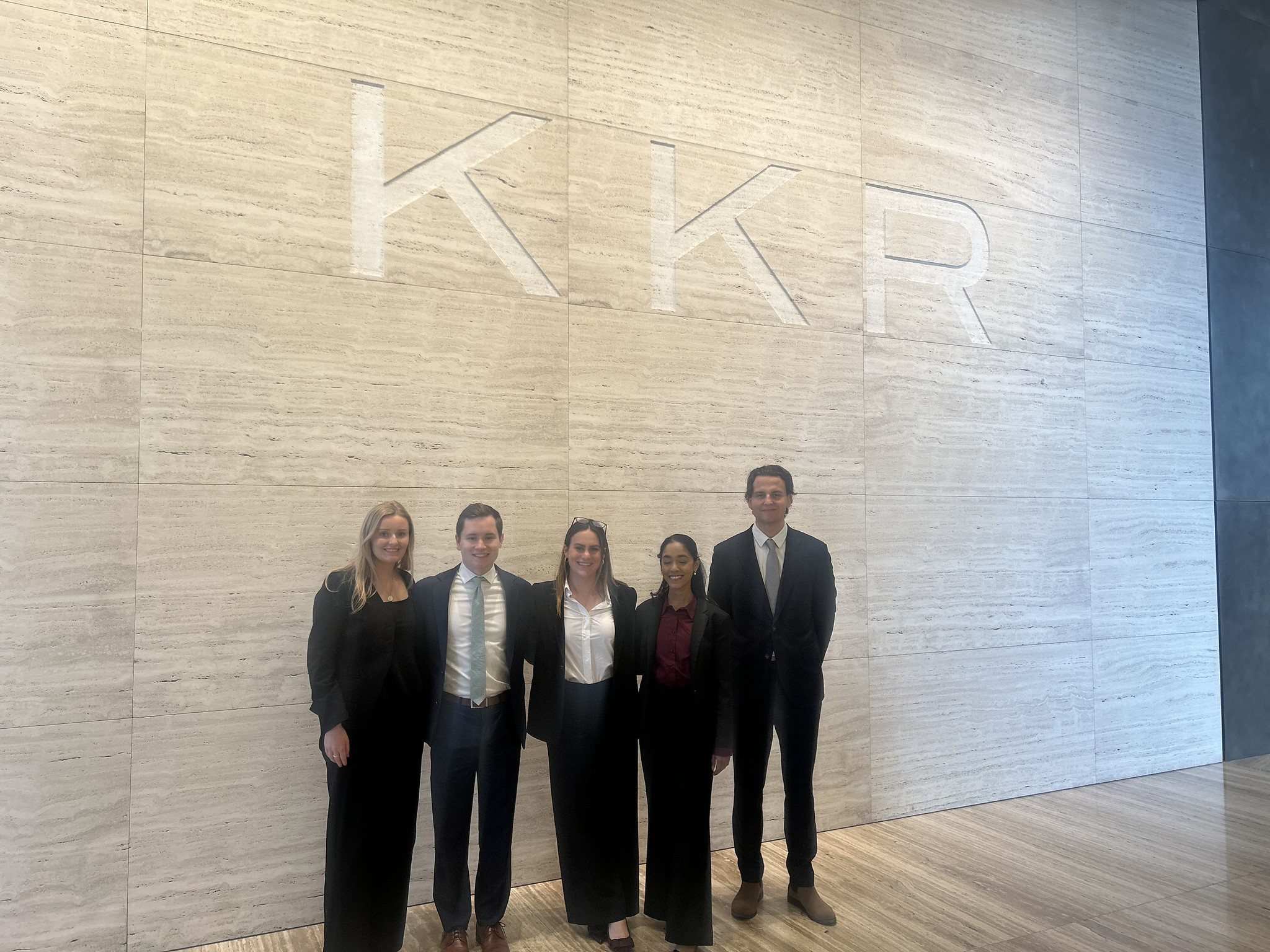
For the first time, a team from the inaugural M.S. in Climate Finance program participated in the prestigious Columbia Business School and KKR Private Equity Case Competition.
Research & Developments is a blog for brief updates that provide context for the flurry of news that impacts science and scientists today.
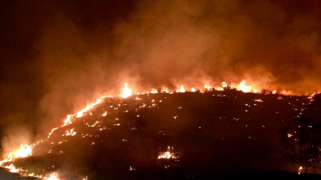
As the midpoint of the year approaches, several climate records have already been broken. Arctic winter sea ice extent reached a record low. Several countries saw record-breaking winter heat waves. And more than 150 million hectares have already burned globally in wildfires.
The increasingly likely emergence of an El Niño this summer will likely continue the year’s record-breaking weather trends and could lead to “an unprecedented year of global fire,” according to a statement from World Weather Attribution, a climate research collaboration.
“In modern human history, we’ve never experienced a strong or very strong El Niño event amid pre-existing conditions that were this warm globally.”
NOAA’s Climate Prediction Center predicts there is a 61% chance of El Niño—a natural climate pattern that involves warming waters in the Pacific Ocean—emerging by July 2026 and persisting through the end of the year. El Niño typically temporarily boosts global temperatures.
At a press briefing on 11 May hosted by World Weather Attribution, climate scientists outlined the potential risks of this emerging El Niño against the backdrop of human-caused climate change, including intensifying wildfire seasons, extreme heat waves, and worsening droughts.
In the press briefing, Frederike Otto, a climate scientist at World Weather Attribution and Imperial College London, emphasized that climate change will likely play a larger role in the rest of this year’s extreme weather events than El Niño will, pointing to more than 100 analyses done by World Weather Attribution that have controlled for the effects of the El Niño Southern Oscillation (ENSO), the broader climate phenomenon that produces El Niño and its sister condition, La Niña.
“We find that human-induced climate change has a much greater influence on the likelihood and intensity of extreme weather events than ENSO,” she said.
Still, El Niño could push average global temperatures to extremes. The effects of El Niño will “be amplified considerably by the now nearly 1.5°C [(2.7°F)] of global warming experienced as of 2026,” Daniel Swain, a climate scientist at the University of California, Los Angeles and the California Institute for Water Resources, said in a statement. “In modern human history, we’ve never experienced a strong or very strong El Niño event amid pre-existing conditions that were this warm globally.”
The global fire season has “got off to a very fast start,” particularly in the African savanna, Southeast Asia, and northeastern China, Theodore Keeping, who studies extreme weather and wildfires at Imperial College London and World Weather Attribution, said in the briefing. Though El Niño may have mixed effects on the U.S. wildfire season, much of the U.S. is expected to face elevated wildfire risk, and a strong El Niño could worsen wildfires elsewhere in the world, particularly in the Amazon rainforest and Australia, Keeping said.
More than 150 million hectares have burned in wildfires so far this year. Credit: Our World in Data, CC BY
“This rapid start [to the wildfire season], in combination with the forecast El Niño, means that we’re looking at a particularly severe year materializing,” Keeping said. “The likelihood of harmful, extreme fires potentially could be the highest we’ve seen in recent history.”
These updates are made possible through information from the scientific community. Do you have a story about science or scientists? Send us a tip at eos@agu.org.