Let’s start with the proven facts: Disclosure Day is the most anticipated film of the summer. Its director and screenwriter, Steven Spielberg, revealed details about its plot this week on one of Stephen Colbert’s final shows: he says it tells the story of the theft by officials, “committed to the truth,” of all information held by the government “about UFOs and extraterrestrial visits,” and the system’s desperate attempts to prevent it being revealed.Seguir leyendo
Let’s start with the proven facts: Disclosure Day is the most anticipated film of the summer. Its director and screenwriter, Steven Spielberg, revealed details about its plot this week on one of Stephen Colbert’s final shows: he says it tells the story of the theft by officials, “committed to the truth,” of all information held by the government “about UFOs and extraterrestrial visits,” and the system’s desperate attempts to prevent it being revealed.
When it comes to photo dumps, NASA has upped the ante. The organization has added thousands of snapshots from the Artemis II mission to the Gateway to Astronaut Photography of Earth archive. The album now holds 12,217 images by cosmic travelers Reid Wiseman, Victor Glover, Christina Koch, and Jeremy Hansen during their more than 250,000-mile, 10-day flyby mission around the moon.
According to PetaPixel, a couple of Nikons and an iPhone 17 were the cameras of choice for the journey. And eve
When it comes to photo dumps, NASA has upped the ante. The organization has added thousands of snapshots from the Artemis II mission to the Gateway to Astronaut Photography of Earth archive. The album now holds 12,217 images by cosmic travelers Reid Wiseman, Victor Glover, Christina Koch, and Jeremy Hansen during their more than 250,000-mile, 10-day flyby mission around the moon.
According to PetaPixel, a couple of Nikons and an iPhone 17 were the cameras of choice for the journey. And even though many of the thousands of recently uploaded images are very similar—some are even quite blurry—scrolling through them gives the impression of being seated right next to the “Moonfarers” as they marvel at Earth and its satellite and simply can’t put the camera down—just like we tend to snap way too many photos of a beautiful sunset.
Some of the most impactful photos include the reflections of the astronauts’ hands and faces in the window of their vehicle, the Orion module. Juxtaposed with meticulously engineered equipment, the earth and moon seem somehow less abstracted from this unique vantage point, in which these orbs appear somehow more resonant and precious—and vulnerable.
Explore more of our favorites below, and learn about the Artemis II mission on NASA’s site.
Research & Developments is a blog for brief updates that provide context for the flurry of news that impacts science and scientists today.
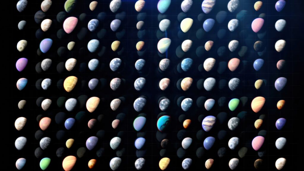
To date, astronomers have confirmed the existence of just under 6,300 exoplanets. New research could more than double that number, adding a potential 10,000 new planets in one fell swoop.
Yes, that’s right. A 1 with 4 zeros.
The T16 project has announced the discovery of 10,091 exoplanet candidates observed by NASA’s Transiting Exoplanet Sur
Research & Developments is a blog for brief updates that provide context for the flurry of news that impacts science and scientists today.
To date, astronomers have confirmed the existence of just under 6,300 exoplanets. New research could more than double that number, adding a potential 10,000 new planets in one fell swoop.
Yes, that’s right. A 1 with 4 zeros.
The T16 project has announced the discovery of 10,091 exoplanet candidates observed by NASA’s Transiting Exoplanet Survey Satellite (TESS). Since 2018, the all-sky survey has been monitoring more than 200,000 nearby stars using the transit method, which detects the faint dip in a star’s light when a planet crosses in front of it. Astronomers typically require 3 dips to be sure that what they’re seeing is actually a planet and not a one-off event such as an asteroid or comet in that distant star system.
The T16 project analyzed the light curves of more than 54 million stars observed during the first year of the TESS mission. The project’s analysis technique allowed it to search for planets around stars up to 16 times fainter than TESS typically searches, drastically increasing the field of discovery.
That’s more than were detected in the entirety of NASA’s Kepler mission and its follow-on K2.
Their pipeline detected 11,554 planet candidates. Of those, 1,052 of those had been detected previously and 411 only had one transit—not enough to confirm a planet.
That leaves 10,091 potential new planets. That’s more than were detected in the entirety of NASA’s Kepler mission and its follow-on K2 and more than double the existing planet candidates from TESS that await confirmation. These discoveries will be published in the Astrophysical Journal Supplement.
All of the new planet candidates orbit their stars quickly, with orbital periods between 12 hours and 27 days. Although most of the stars that TESS observes are smaller and cooler than the Sun, those close orbits likely mean that most of those planets are far too hot to be habitable.
The T16 project team confirmed the planet-hood of one of their candidates not using the transit method, but a different method that measures the gravitational tug a planet exerts on its host star. That planet, TIC 183374187, is hot and slightly larger than Jupiter.
The remaining 10,090 newly discovered planet candidates require additional verification to determine whether they truly are planets or not. But given the rigor of the team’s analysis and the requirement of at least 3 transits to even make this list, it’s likely that most of the new discoveries are indeed planets.
“Astronomers are a bit conservative when it comes to claims like this, and want to be sure they pass a bunch of tests to make sure everything was done correctly and these planets actually exist,” astronomer Phil Plait wrote in his Bad Astronomy Newsletter. “Having said that, the process the astronomers went through looks legit to me, and I would bet the majority of these new candidates are real. That’s amazing.”
These updates are made possible through information from the scientific community. Do you have a story about science or scientists? Send us a tip at eos@agu.org.
For the first time in more than 50 years, NASA launched a mission to the Moon. A lot has changed since 1972, when we last checked in on the enormous, rocky satellite, but there is much to learn—and revisit—when it comes to traveling through deep space and considering what, as NASA describes it, a “long-term return” to our lunar companion could look like. The Artemis II mission, which is currently underway and scheduled to last a total of 10 days, has also released some remarkable images of ou
For the first time in more than 50 years, NASA launched a mission to the Moon. A lot has changed since 1972, when we last checked in on the enormous, rocky satellite, but there is much to learn—and revisit—when it comes to traveling through deep space and considering what, as NASA describes it, a “long-term return” to our lunar companion could look like. The Artemis II mission, which is currently underway and scheduled to last a total of 10 days, has also released some remarkable images of our home planet.
A striking image of the Earth “setting” behind the cratered Moon takes a truly unique view of our planet and prompts us to consider our perspective. It’s reminiscent of one of the most iconic photographs of all time, known as “Earthrise,” which was snapped by astronaut William Anders during the 1968 Apollo 8 mission—the first crewed trip to the Moon.
The Earth setting beyond the Moon
Artemis II is scheduled to return to Earth on the evening of April 10, when the crew will splash down into the Pacific Ocean off the California coast.
The Moon’s cratered surfaceThe far side of the Moon
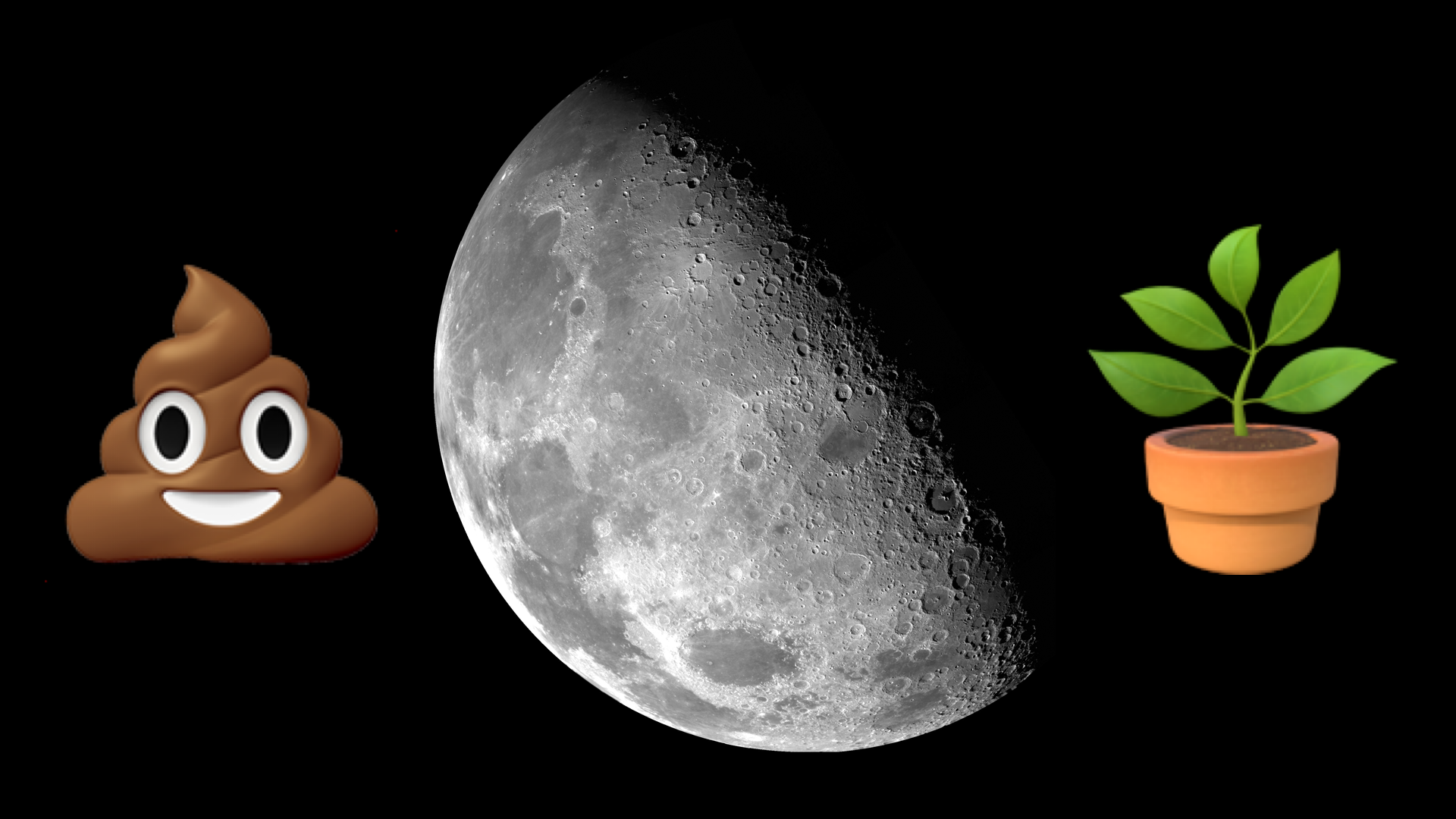
NASA’s ambitious plan to put humans on the moon may hinge on the bathroom habits of a handful of University of North Dakota grad students. In the name of science, those researchers will test the limits of a mobile wastewater treatment system designed to convert human waste into plant nutrients and other sustainable materials. The trial will serve as a stress test of sorts, measuring how well the Divergent Deployable Wastewater Treatment Facility holds up to regular use and heavy loads in an envi
NASA’s ambitious plan to put humans on the moon may hinge on the bathroom habits of a handful of University of North Dakota grad students. In the name of science, those researchers will test the limits of a mobile wastewater treatment system designed to convert human waste into plant nutrients and other sustainable materials. The trial will serve as a stress test of sorts, measuring how well the Divergent Deployable Wastewater Treatment Facility holds up to regular use and heavy loads in an environment designed to mirror a lunar habitat.
It’s not pretty work, but someone has to do it.
“The tests will help NASA evaluate real-world operation, crew training needs, system reliability, and how wastewater simulants compare with actual human metabolic waste in an analog mission environment,” Ali Alshami, University of North Dakota Chemical Engineering professor and test participant, said in a statement.
The unassuming gray building could one day be an astronaut wastewater facility. Technicians prepared the Divergent Deployable Wastewater Treatment Facility for transport at NASA’s Kennedy Space Center in Florida on April 21, 2026. Image: NASA/Kim Shiflett
Treated astronaut poop will feed lunar plants
The mobile facility consists of three separate bioreactors, each tasked with handling a specific kind of waste. Feces, urine, and food waste are treated separately because each material contains different levels of salts, solids, carbon, nitrogen, and phosphorus. One reactor processes feces and food waste, converting it into nutrient-rich water that can feed plants. The other two handle urine and greywater from activities like showering and laundry, some of which can be filtered and recycled into clean drinking water. From an astronauts’ perspective, the experience should feel pretty familiar to life onboard the International Space Station (ISS). They use the toilet as normal, and it automatically diverts waste at the source, routing each type to its corresponding bioreactor.
The whole process takes place in a mobile, 8.5-by-24-foot trailer. In addition to the bioreactors, the unit also houses a vertical garden maintained by the converted wastewater. The goal is to kill two birds with one stone: process waste efficiently and then use it to sustain lunar agriculture. Both are essential if astronauts want any shot at building longer-term habitats on the moon or even Mars. To that end, NASA has ambitions to start constructing a semi-permanent lunar structure or “moon base” by 2029.
Where no one has gone before
Waste management in space has come a long way since the first moon missions. Back in the 1960s, NASA Apollo astronauts left behind 96 bags of human waste (filled with poop, urine, and vomit) on the lunar surface to save weight. Those bags are almost certainly still there.
Thankfully, decades of research mean astronauts no longer have to relieve themselves into a bag, at least not most of the time. The most recent Artemis mission featured a fully functional space toilet, though it malfunctioned almost immediately after liftoff.
Recycling wastewater has also seen major improvements. NASA had a breakthrough in 2023 when its life support system aboard the ISS managed to recover nearly 98 percent of all breath, sweater, and urine brought aboard by the crew. Future astronauts on prolonged spacewalks may also wear this Dune-inspired backpack that filters urine and sweat into drinking water in a single self-contained loop.
Editors’ Vox is a blog from AGU’s Publications Department.
As climate change increases the frequency and intensity of flooding, it’s becoming increasingly important to monitor and predict flood hazards at different scales. A new article in Reviews of Geophysics presents a data-driven performance analysis of various space-based sensors that monitor flood hazards. Here, we asked the lead author to give an overview of satellite-based flood monitoring, the benefits and challenges of using satell
As climate change increases the frequency and intensity of flooding, it’s becoming increasingly important to monitor and predict flood hazards at different scales. A new article in Reviews of Geophysics presents a data-driven performance analysis of various space-based sensors that monitor flood hazards. Here, we asked the lead author to give an overview of satellite-based flood monitoring, the benefits and challenges of using satellite-based sensors, and future space-based projects.
Why is it important to monitor the surface waters on Earth?
More than half of the world’s population lives within three kilometers of a freshwater body. When seasonal flooding behaves as anticipated, it provides essential nutrient replenishment to soils and crops. However, extreme flooding disturbs the careful balance of freshwater systems and can cause damaging flooding that disrupts livelihoods.
Climate change is making these extremes more frequent and less predictable, while expanding populations in flood-prone areas amplify the human cost. Continuous monitoring of Earth’s surface waters is essential as it helps us anticipate hazards, evaluate risk, and design interventions that protect the people and places most exposed to hydrologic hazards.
What are the benefits of monitoring flood inundation from space compared to other techniques?
Monitoring flood inundation from space is advantageous due to the wide-scale global coverage that captures important information over large areas. In-situ sensors, such as river gauges, provide valuable data but are limited in spatial coverage and may even fail under significant flood conditions. A single satellite overpass can potentially capture an entire river basin, allowing responders to see where water has spread, which communities are affected, and how the event is evolving.
When did scientists first start using satellites to monitor surface waters?
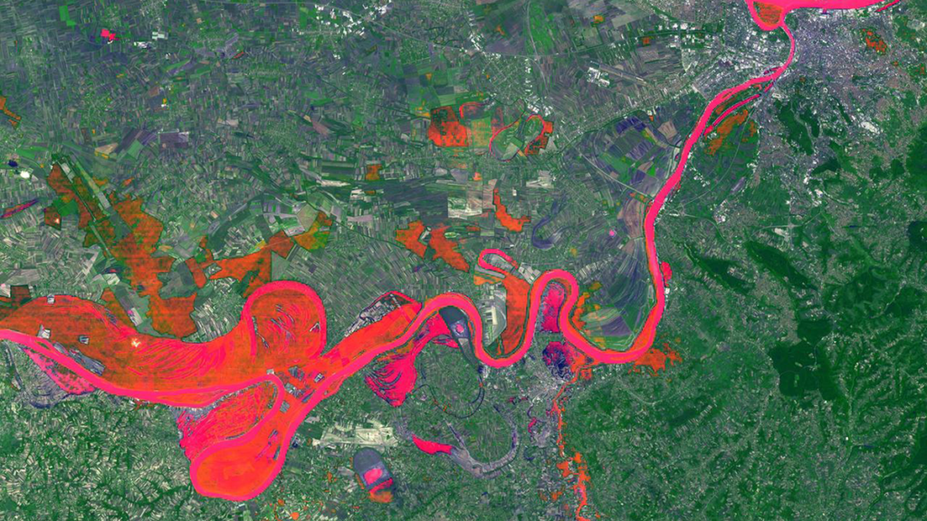
The value of monitoring surface water from space was first realized in the early 1970s, following the launch of Landsat 1. Soon after launch, it captured imagery of the devastating 1973 Mississippi River floods, producing one of the first flood maps made from space (Figure 1). By the early 2000s, NASA’s MODIS sensors were providing global coverage at a daily frequency. Today, multiple global flood monitoring systems are in place, including the European Union’s Copernicus Emergency Management Service, which maps floods using Sentinel-1 synthetic aperture radar (SAR), and NOAA’s VIIRS Flood Mapping system.
Figure 1. Imagery from the start of the Landsat 1 mission illustrating the extent of the Mississippi River flooding of 1973 (EROS History Project). The Earth Resources Technology Satellite 1 (ERTS-1) was renamed Landsat 1 in 1975. Credit: USGS
What are the three types of satellite-based sensors that your review focuses on?
Our review examines three families. Multispectral (optical and thermal) sensors capture reflected sunlight or emitted heat. Microwave sensors, including SAR, passive microwave radiometers, and GNSS Reflectometry (GNSS-R), can observe through clouds and at night but involve trade-offs between resolution and coverage. Finally, altimetric sensors measure water surface elevation with high precision but only along narrow tracks. Each family has distinct strengths and weaknesses that lend themselves to use in combination for comprehensive flood inundation monitoring.
What are some of the challenges of using satellite-based sensors to monitor flooding?
The fundamental problem is that floods and satellite observations are mismatched in time and space. Optical sensors often capture clouds rather than the floodwater beneath. Cloud-penetrating sensors like SAR can miss flood peaks if their orbital schedule doesn’t align with the event, and dense vegetation can obstruct floodwater from both optical and shorter-wavelength radar. Sensors with high temporal resolution typically deliver data at coarse spatial resolutions, sometimes tens of kilometers per pixel. These trade-offs form what we describe as the “iron triangle” of Earth observation: temporal resolution, spatial resolution, and cost. A sensor can typically be optimized for two, but rarely all three. Occasionally, the timing and conditions of a flood align well with sensors whose strengths are complementary across the iron triangle, yielding the kind of multi-sensor view shown in Figure 2.
Figure 2. Sentinel‐2 MSI True Color Image with Sentinel‐1 SAR derived flood‐extent superimposed on top. The top right circle highlights the missing SAR‐derived information, whereas the bottom circle highlights the missing optical information. Credit: Campo et al. [2026], Figure 5
What are some upcoming space-based sensor projects that could advance the field of hydrology?
Several are already reshaping the field. NISAR, a joint NASA–ISRO radar satellite launched in 2025, carries an L-band sensor designed to penetrate vegetation canopy, providing new insights into flooding beneath vegetation. Sentinel-1D, launched in late 2025, has restored the Sentinel-1 constellation to full two-satellite capacity, halving the revisit time. Landsat Next, a planned three-satellite constellation with 26 spectral bands and a six-day revisit, would provide valuable hydrologic data at both high temporal and spectral resolutions. However, recent budget pressures have introduced uncertainty about its final scope. Finally, the HydroGNSS mission from ESA will use GNSS-R to monitor hydrologically linked Essential Climate Variables.
Editor’s Note: It is the policy of AGU Publications to invite the authors of articles published in Reviews of Geophysics to write a summary for Eos Editors’ Vox.
Citation: Campo, C. (2026), Can any single satellite keep up with the world’s floods?, Eos, 107, https://doi.org/10.1029/2026EO265016. Published on 20 April 2026.
This article does not represent the opinion of AGU, Eos, or any of its affiliates. It is solely the opinion of the author(s).
From rivers and oxbow lakes to crop-field patchworks and mineral sediments, Landsat has seen it all. A program of NASA and USGS, the satellite initiative has documented the Earth’s surface since 1972, making it the longest continuous record of our planet’s ever-evolving landscapes. And to mark Earth Day 2026, the organizations launched a playful way to interact with some of their findings collected over the past five-and-a-half decades—a name generator.
Using the tool is simple: type in yo
From rivers and oxbow lakes to crop-field patchworks and mineral sediments, Landsat has seen it all. A program of NASA and USGS, the satellite initiative has documented the Earth’s surface since 1972, making it the longest continuous record of our planet’s ever-evolving landscapes. And to mark Earth Day 2026, the organizations launched a playful way to interact with some of their findings collected over the past five-and-a-half decades—a name generator.
Using the tool is simple: type in your name, or any word, and Landsat returns it in the form of vertical snapshots of a wide range of terrain. Just like we see with composites of Mars, for instance, scientists have digitally enhanced some images to highlight specific features. Those used for “Your Name in Landsat” sport a wide array of hues, textures, and patterns that glimpse the diversity of our planet’s surface.
“Colossal”
Landsat is an incredible resource that features time-lapses of changing land use over several decades. Even this playful name generator allows you to hover over individual images and learn the exact locations—down to the coordinates—and all of the program’s data is publicly accessible. For example, the “C” in “Colossal” above is a vertical view of a cloud-speckled Deception Island in Antarctica, and the “A” is the uniquely shaped Lake Mjøsa in Norway.
You might also enjoy Overview, a book that chronicles how the landscape has changed over time. Learn more about Landsat from NASA. (via PetaPixel)
Anything unfortunate enough to venture too close to a black hole inevitably falls prey to the gargantuan object’s inescapable gravitational pull. But that doesn’t mean a black hole is constantly devouring its next cosmic meal. In many cases, there comes a time when there simply isn’t anything left in its vicinity to consume. Although these dormant black holes don’t go anywhere, astronomers have a tough time detecting and observing them.
That hasn’t stopped researchers from successfully spotti
Anything unfortunate enough to venture too close to a black hole inevitably falls prey to the gargantuan object’s inescapable gravitational pull. But that doesn’t mean a black hole is constantly devouring its next cosmic meal. In many cases, there comes a time when there simply isn’t anything left in its vicinity to consume. Although these dormant black holes don’t go anywhere, astronomers have a tough time detecting and observing them.
That hasn’t stopped researchers from successfully spotting the most distant example ever seen. At over 10 billion light-years from Earth, the dormant black hole inside the galaxy MRG-M0138 is 15 times farther away than the prior record holder. As astronomers explained in a study published on June 4 in the journal Science, the far-away subject is now offering experts an unprecedented look at one of the earliest regions of the universe.
To pull off the remarkable achievement, researchers harnessed both the James Webb Space Telescope as well as a technique called stellar dynamics, which utilizes the movements of stars around an invisible black hole to assess its mass. This approach has previously helped identify similar cosmic objects inside galaxies, including our own Milky Way, but never at such a great distance.
Astronomers wouldn’t be able to locate any stars moving around such a far away black hole in most scenarios. However, a galaxy located directly between Earth and MRG-M0138 enabled the otherwise impossible task through a dynamic known as gravitational lensing. Incoming light from MRG-M0138’s stars is refracted around the intermediary galaxy, which then refocuses and enlarges its appearance by 30 times its normal size. This then allowed astronomers to track and calculate the distant stellar dynamics around the dormant black hole.
JWST and gravitational lensing enabled an international team of astronomers led by Carnegie Science’s Andrew Newman to measure the mass of a dormant black hole from the early universe for the first time. Credit: Navid Marvi / Carnegie Science
“By combining JWST data with gravitational lensing, we could peer inside the black hole’s sphere of influence, where its gravity boosts the speeds of stars,” study co-author and Carnegie Science astronomer Andrew Newman said in a statement. “This is one of the best techniques we have to weigh a black hole, so we were excited to extend it to a much earlier period in cosmic history.”
After crunching the numbers, Newman and colleagues determined the dormant black hole has a mass about six billion times greater than the sun, and is observable from an era when the universe was barely three billion years old. That’s around a quarter of its age today, which means astronomers are now glimpsing some of the earliest moments in cosmic history.
Experts have already determined that it’s not just MRG-M0138’s black hole that is dormant—the entire galaxy itself is basically silent, with no recently formed stars. The study authors also theorize the galaxy previously included a quasar, which emits huge amounts of radiation and are some of the brightest objects in the universe.
Moving forward, astronomers can now apply their methodology to other areas of the cosmos, as well as gain a better understanding of galactic evolution throughout the eons.
“By demonstrating the feasibility of such a technique for galaxies in the early universe, we can now undertake a more complete census of how black holes develop over time and infer their role in shaping galaxy evolution,” added study co-author and University College London astronomer Richard Ellis.
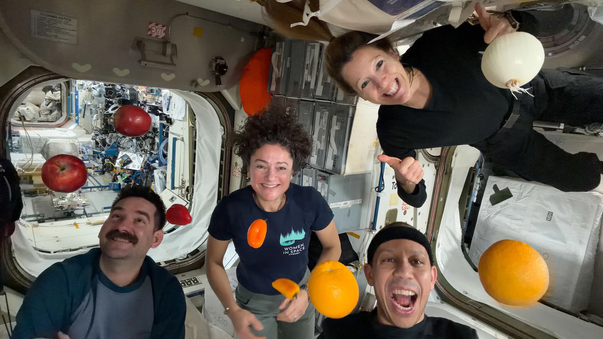
Astronaut food has come a long way from the freeze dried packets aboard the Apollo missions. During their historic lunar fly-by in April, the Artemis II crew dined on beef brisket, mac and cheese, quiche, and a lot of tortillas. The same can be said for the hungry inhabitants of the International Space Station (ISS). With regularly scheduled restocks, the astronauts don’t have to worry as much about issues like shelf life. That means that even when nearly 250 miles above Earth, ISS residents can
Astronaut food has come a long way from the freeze dried packets aboard the Apollo missions. During their historic lunar fly-by in April, the Artemis II crew dined on beef brisket, mac and cheese, quiche, and a lot of tortillas. The same can be said for the hungry inhabitants of the International Space Station (ISS). With regularly scheduled restocks, the astronauts don’t have to worry as much about issues like shelf life. That means that even when nearly 250 miles above Earth, ISS residents can still snack on fresh fruit and vegetables.
NASA highlighted one such astronaut grocery delivery in a photo released on May 14. Taken on April 19, astronauts Jack Hathaway, Jessica Meir, Chris Williams, and Sophie Adenot are seen in microgravity alongside what are presumably upcoming snacks like oranges, apples, peppers, and one conspicuous onion.
Food wasn’t the only precious cargo on the Cygnus XL spacecraft visit that month, however. In addition to the colorful produce, the ISS also received over 2,300 pounds of research hardware and science equipment. These materials encompass the tools the crew needs for their research on blood stem cells for cancer treatments and ways to strengthen astronaut gut health. The ISS is now also home to a new exercise machine, courtesy of the European Space Agency, as well as replacement nitrogen and oxygen tanks for spacesuits.
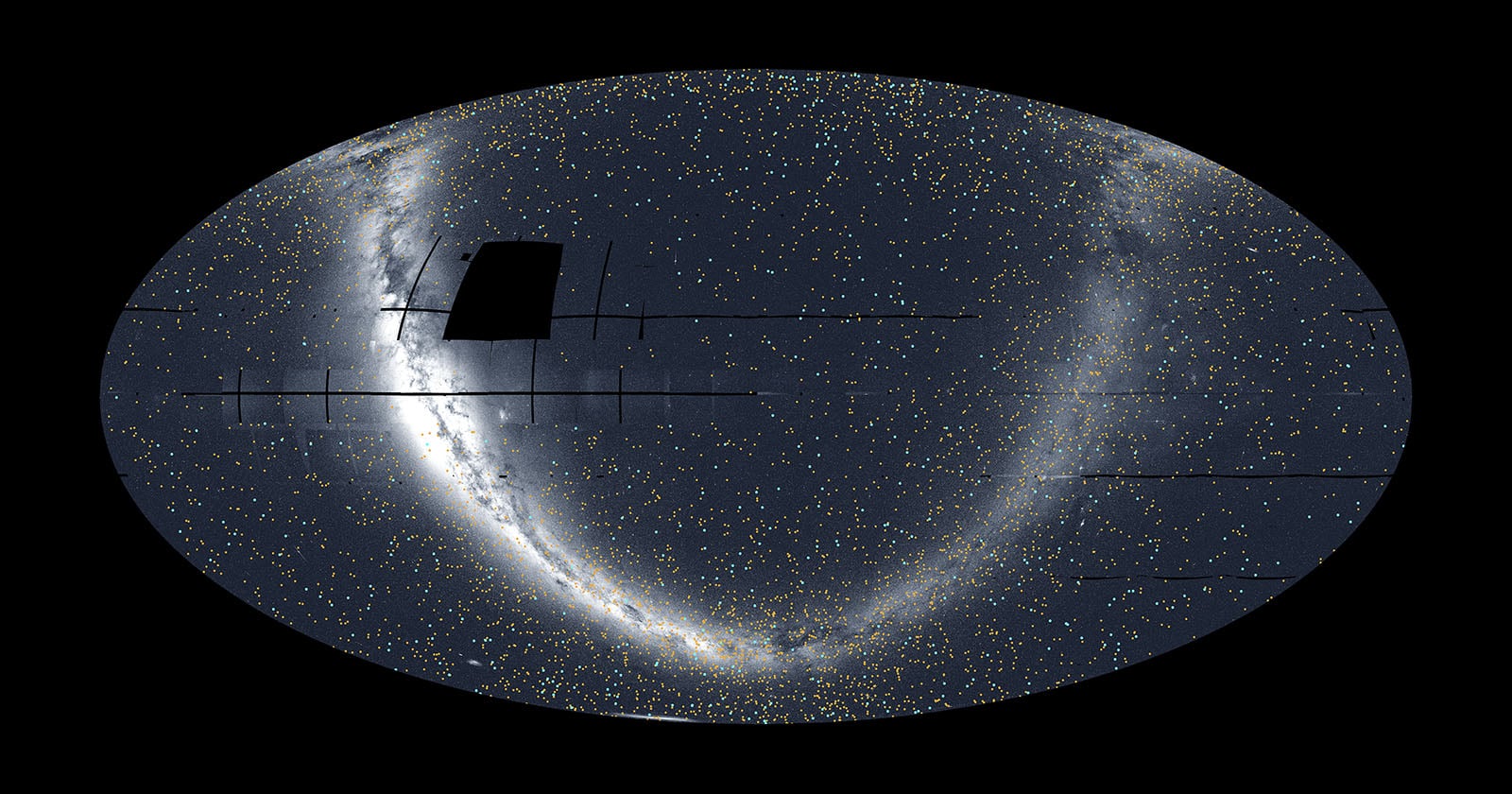
NASA's Transiting Exoplanet Survey Satellite (TESS) has released a new mosaic that offers its most complete view of the night sky yet. Captured over eight years, the all-sky mosaic includes 679 confirmed, newly discovered exoplanets and nearly 5,200 candidate exoplanets.
[Read More]
NASA's Transiting Exoplanet Survey Satellite (TESS) has released a new mosaic that offers its most complete view of the night sky yet. Captured over eight years, the all-sky mosaic includes 679 confirmed, newly discovered exoplanets and nearly 5,200 candidate exoplanets.
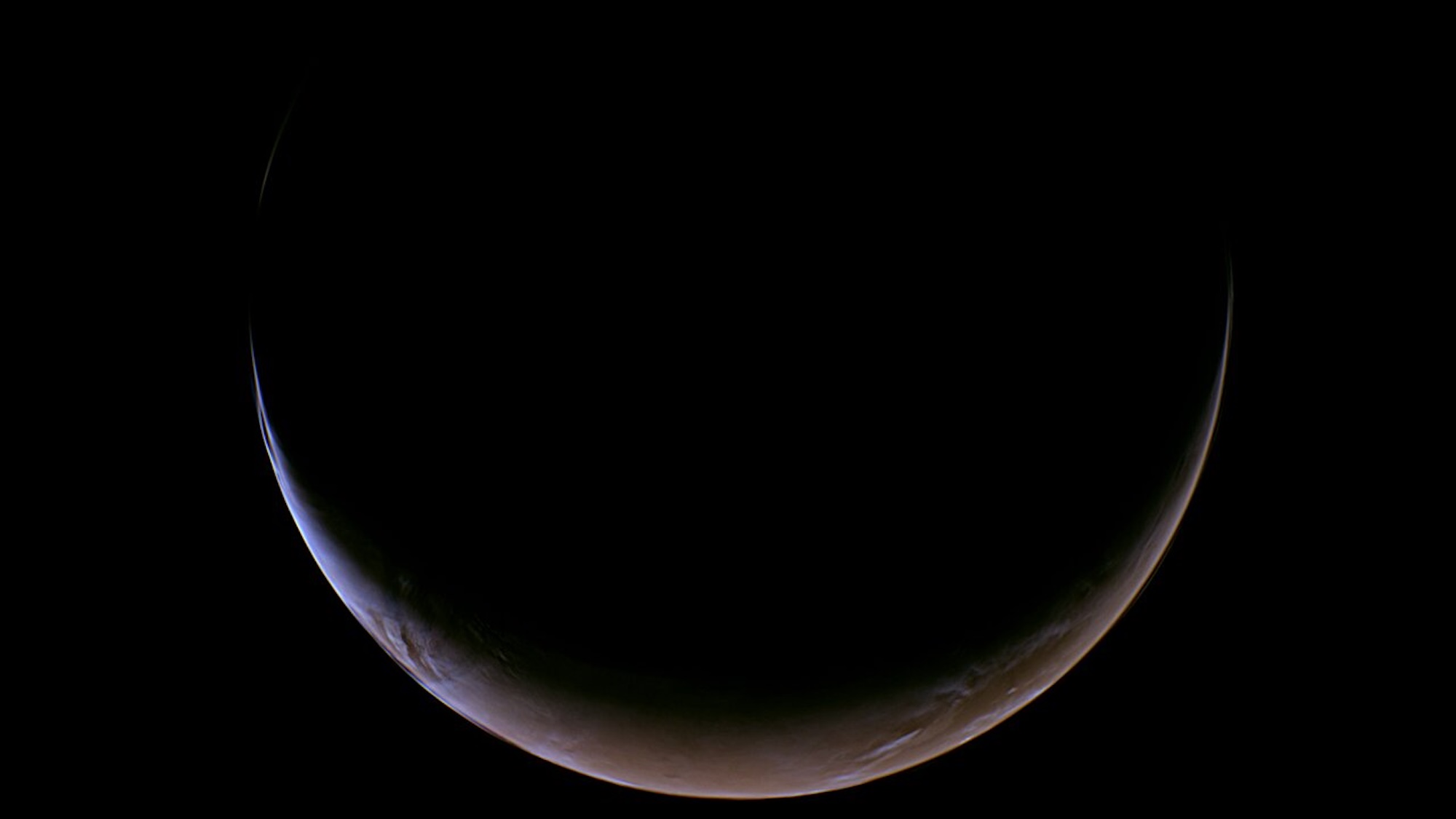
NASA’s Psyche spacecraft is currently en route to a small, metal-rich asteroid near Jupiter. However, the barely 3,600-pound probe recently required a little help from Mars to complete its lengthy 2.2-billion-mile mission. Despite its complex gravity assist earlier this month, the groundbreaking spacecraft still found time to snap some travel photos showcasing its Red Planet flyby. NASA released the latest image from Psyche’s trip on May 20, which offers a gorgeous view of Mars just hours before
NASA’s Psyche spacecraft is currently en route to a small, metal-rich asteroid near Jupiter. However, the barely 3,600-pound probe recently required a little help from Mars to complete its lengthy 2.2-billion-mile mission. Despite its complex gravity assist earlier this month, the groundbreaking spacecraft still found time to snap some travel photos showcasing its Red Planet flyby. NASA released the latest image from Psyche’s trip on May 20, which offers a gorgeous view of Mars just hours before Earth’s neighbor temporarily eclipsed the cosmic traveller.
According to NASA, the image was taken on May 15 at about 8:03 a.m. EDT by the spacecraft’s multispectral imager instrument. The thin crescent view of Mars is due to the spacecraft’s approach at what’s known as a high phase angle. The fingernail slice of Red Planet actually looks brighter and wider than mission specialists anticipated, thanks to a large level of sunlight scattering through the dusty Martian atmosphere. Interestingly, the instrument’s original unfiltered image wouldn’t look very discernible to the human eye. Instead, scientists processed the photo into a natural-color palette using the probe’s red, blue, and green imager filter data.
Launched in October 2023, Psyche is destined for 16 Psyche, a 140-mile-wide rock that astronomers theorize may be the remnant of an ancient planetary core. Once there, the spacecraft will study its iron magnetic properties, as well as use its imagers and spectrometers to analyze the asteroid’s chemical and elemental compositions.
Thanks to the Martian gravity assist, Psyche is scheduled to reach its destination in 2029. At its closest pass, Psyche swung around the Red Planet barely 2,800 miles above the surface at a speed of around 12,333 miles per hour.