All of that is correct. But it misses a structural problem inherent in agency governance, one that will recur at every reorganization until the Earth science community builds an instrument to prevent it.
In massive reorganizations like the ones federal agencies are currently experiencing, the threat to long-term research facilities is not primarily a lack of funding. The true threat is an oversight of administrative architecture. There appears to be no general federal requirement to have a successor stewardship plan in place before reducing the output or outreach of a long-term research facility—or closing it entirely.
The Physical Archive Is Not a Digital File
Hubbard Brook Experimental Forest in New Hampshire was among the sites under review during the Forest Service restructuring but has since received a public reprieve. The future of Bartlett Experimental Forest, also in New Hampshire, remains unresolved. The governance problem, however, extends beyond either site.
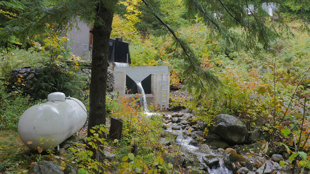
Hubbard Brook’s physical archive holds more than 60,000 barcoded and cataloged samples: water, soils, plant material, and physical cores spanning 7 decades of continuous collection and stored under active environmental controls in a dedicated building on site.
These samples cannot be digitized. They cannot be migrated to a remote server, backed up to cloud storage, or emailed to a university partner. The samples require a functioning building, active temperature management, and a named human steward responsible for their integrity.
The physical archive at Hubbard Brook holds more than 60,000 barcoded and cataloged samples stretching back to the founding of the facility in 1955. Credit: Anthony Veltri
The archive includes core samples of trees dating to long before the experimental forest was established, and the archive maintains each as a managed scientific record with continuity of custody. Credit: Anthony Veltri
Core samples like these document the watershed at Hubbard Brook and anchor long-term understanding of system processes. Credit: Anthony Veltri
The archive at Hubbard Brook is impressive, but a governed record is defined by continuity, provenance, and stewardship, not by the number of observations it contains: Data volume is not data value. A 70-year unbroken record of watershed chemistry, maintained by named stewards who documented what they were measuring and why, is a governed product. Without that stewardship and physical anchor, volume can become noise.
The failure to maintain archives like this is likely not malicious; it is an example of administrative indifference or perhaps a lack of awareness or understanding. Environmental controls, for example, get zeroed out of a budget line item, and nobody notices until the temperature in the facility drifts. By then, the sample record has degraded in ways that cannot be reversed.
This Is Not a Hubbard Brook Problem
Many physical archives, calibration sites, and long-duration sampling programs operate without a formal requirement for stewardship continuity.
Hubbard Brook is the most visible instance of a pattern—the lack of a successor stewardship plan—that runs across the entire 84-site federal Experimental Forests, Ranges, and Watersheds network. The March order that identified Bartlett Experimental Forest and 56 other research facilities across 31 states for closure was executed without a mandatory requirement to identify successor stewards for what gets left behind.
Nor is the pattern unique to experimental forests. The Long Term Ecological Research network spans 28 core sites. AmeriFlux includes more than 500 monitoring locations across North America.
Throughout all these systems, many physical archives, calibration sites, and long-duration sampling programs operate without a formal requirement for stewardship continuity under agency reorganization.
What We Stand to Lose
Long-term physical archives provide scientists and other stakeholders the ability to ask future questions of past reality. Nobody collecting water samples at Hubbard Brook in 1963 was thinking about PFAS (per- and polyfluoroalkyl substances), for instance, but the baseline its site samples provide is why we can track the chemicals today. The same continuous record was central to the regulatory science behind the Clean Air Act amendments of 1990.
Archival value compounds silently and becomes visible only when someone needs it.
Archival value compounds silently for decades and becomes visible only when someone needs it.
When these archives fail, the loss is not historical. It is operational. Regulatory agencies rely on long-baseline records to determine whether interventions are working. Without a continuous physical reference, observed changes cannot be distinguished from measurement drift, instrumentation bias, or natural variability. The results are policy decisions made without a defensible scientific baseline.
Federal investment in continuous collection at a site like Hubbard Brook runs to tens of millions of dollars over decades. That investment is not recoverable once continuity is broken.
Unlike a paused research grant, a degraded physical archive cannot be restarted. You can photograph a sample, but you cannot rerun its chemistry 40 years from now if the physical sample has degraded.
In 2017, a double mechanical failure at the University of Alberta destroyed 12.8% of the Canadian Ice Core Archive over a single weekend, permanently erasing records dating back 12,000 years. That incident was accidental. A mechanical malfunction is a failure of equipment. Administrative disposal without a named successor steward is a failure of governance. One arrives without warning. The other can be prevented.
The Community Already Knows How to Do This
The Earth observation community has already built the governance model we need. We are not yet applying it to long-term ecological research infrastructure.
GRUAN, the Global Climate Observing System (GCOS) Reference Upper-Air Network, operates under the World Meteorological Organization and GCOS, with explicit named stewardship obligations. Upper-air observations—measurements of temperature, humidity, and wind through the atmosphere—are foundational inputs to weather forecasting and climate monitoring. Each GRUAN station has a designated principal investigator with a documented succession obligation.
ICOS, the Integrated Carbon Observation System operating across Europe, applies the same logic to terrestrial ecosystem observations through formal site-level stewardship agreements and named succession requirements.
In the United States, the National Ecological Observatory Network is funded by the National Science Foundation (NSF) and operated by Battelle, a science and technology nonprofit, under a contract that includes explicit data continuity obligations.
These systems did not emerge by accident. They were explicitly designed to solve a known failure mode: Distributed observational networks cannot maintain their own calibration integrity without a separately governed reference layer. That design decision is documented, enforced, and funded. The absence of an equivalent requirement in long-term ecological research infrastructure is not a technical limitation. It is a governance omission.
The pattern is consistent across every network that has solved this problem: Named continuity obligations must be written into the governance structure before the need becomes acute.
The Governance Instrument
The best outcome is the continued, uninterrupted operation of facilities like Hubbard Brook.
Any federal agency action that would reduce operational support for a long-term research facility should require a formal continuity plan before the action takes effect.
If reductions move forward, however, the proposed fix is specific and not novel: Any federal agency action that would reduce or eliminate operational support for a long-term research facility should require a formal continuity plan before the action takes effect. That plan must name a successor steward for each active long-term dataset and for each physical archive under active environmental control.
In practice this means specificity: the name and institutional affiliation of the successor, a funded maintenance budget sufficient to sustain environmental controls and sample integrity, documented protocols for custody transfer, and a timeline for uninterrupted handoff. The plan must demonstrate that the successor steward has the operational capacity and funded mandate to preserve the archive’s physical integrity and continuity.
This instrument prepares plant samples collected at Hubbard Brook using standardized methods. Consistent preparation is what makes results comparable across time and labs and why continued stewardship is so important. Credit: Anthony Veltri
The default should be continued stewardship by the responsible federal entity. If a change in custody is legally permitted and genuinely unavoidable, any successor steward, whether another federal unit, a university partner, a consortium, or another entity, must have a funded mandate, demonstrated technical capacity, enforceable continuity obligations, and the ability to maintain the archive without interruption.
Protocol demands that if the agency cannot name a viable successor steward, the agency cannot execute the closure. This requirement does not prohibit closure; it prohibits closure without continuity of custody.
The instrument requiring a research facility to have a formal continuity plan should be applied not on a site-by-site basis, but uniformly across networks. A limitation narrowly written to protect a named facility invites the agency to execute the same administrative disposal at adjacent sites while technically complying with the specific requirement. The governance is structurally sound only if it applies across the network.
How This Actually Happens
The pathways that would make such an instrument possible already exist.
Agencies can impose continuity requirements through policy directives, appropriations language, or funding conditions. The federal Office of Science and Technology Policy and the Office of Management and Budget have coordinated interagency data management guidance before, and a directive requiring named successor stewardship before any facility reduction does not require legislation. Sen. Jeanne Shaheen (D-NH) has already secured fiscal year 2026 language directing the Forest Service to prioritize staffing at long-standing experimental forests; attaching successor stewardship language is the logical next step. NSF, the Department of Energy, and NOAA could require stewardship continuity guarantees from partner agencies as a condition of incorporating facility data into federally funded continental-scale products.
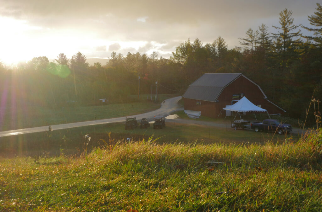
Scientists recognize that agencies reorganize and funding for facilities can be downgraded. That is why preserving a continued record of any long-term research facility must be part of the facility’s governance structure from the outset. Credit: Anthony Veltri
What is missing is the requirement itself—and the strategic initiative to establish it. The Earth science community has the standing, the documented models, and the mechanisms to close those gaps.
This is not an argument against reorganization. Agencies reorganize. Budgets shift. Research priorities evolve.
The argument is that reorganization cannot be permitted to destroy multigenerational scientific infrastructure through administrative indifference when a specific, enforceable governance requirement can prevent it. The Earth observation community built GRUAN because it recognized that no federation of climate datasets can be a substitute for a governed anchor point. Long-term ecological research infrastructure needs the same recognition applied to the administrative layer that governs its continuity.
The scientific enterprise already knows how to do this. The governance has not caught up yet.
Author Information
Anthony Veltri (anthony@anthonyveltri.com) is an independent practitioner and former physical scientist and senior policy analyst with the USDA Forest Service Washington Office, where he worked on enterprise architecture and governance in federal programs, including those supporting scientific research.
Citation: Veltri, A. (2026), The governance gap threatening long-term ecological archives, Eos, 107, https://doi.org/10.1029/2026EO260172. Published on 27 May 2026.
This article does not represent the opinion of AGU, Eos, or any of its affiliates. It is solely the opinion of the author(s).
EXCLUSIVE: Nateland Entertainment, the production company of Nate Bargatze, has expanded its podcast network with the signing of Anjelah Johnson-Reyes’ Funjelah. The company also this morning announced the launch of Life of Dad, a new pod hosted by Tom Riles, Mike James and Lee Kimbrell, as well as the renewal of its shows The Consumers and Correct Opinions for a second season. […]
Since the beginning of the 20th century, global sea level has risen by about 20 centimeters (roughly 8 inches) [Fox-Kemper et al., 2021]. As a result, coastal and island communities around the world are experiencing more frequent high-tide flooding, worsening storm surges, and increasing damage to homes and infrastructure. In the United States, for example, human-caused sea level rise alone increased damages from 2012’s Hurricane Sandy by about $8 billion [Strauss et al., 2021].
The United States has long been a key member of the global climate research community. However, that role is now threatened.
Scientific understanding of the magnitudes and rates of sea level rise, of how they vary around the planet, and of why the ocean is rising is based on a body of rigorous research that, for decades, has tracked past and present sea levels and projected future rise.
The United States has long been a key member of the global climate research community, including in producing the wealth of sea level research that has informed countries, states, and communities of what lies ahead for their shorelines. However, that role is now threatened by the Trump administration’s attacks on the country’s scientific research enterprise broadly and on climate research especially.
Analysis of the evolution of sea level rise projection science [Garner et al., 2018] underscores both the country’s prominent past role in the field and how the ongoing attacks may undermine progress in our understanding of sea level change. It also points to the urgency of acting across multiple fronts to preserve scientific knowledge and prevent further harm to the capacity to measure and project how much and how fast rising seas will affect global coastlines.
Four Decades of Advancing Sea Level Science
By the late 1970s, scientists around the world had begun to recognize the growing threat that climate change posed to the Greenland and Antarctic ice sheets and the danger their melting presented to coastal regions [Mercer, 1978]. The first global mean sea level (GMSL) projections were published in 1982 [Gornitz et al., 1982], and the first planning-oriented sea level scenarios were published just a few years later [e.g., National Research Council, 1987].
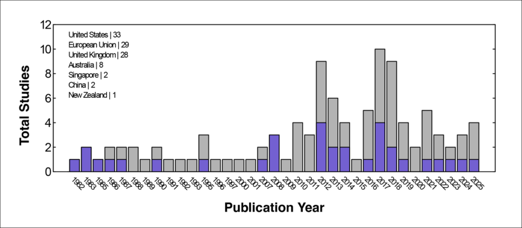
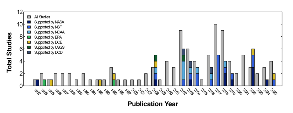
Since 1982, 103 studies have produced GMSL projections [Garner et al., 2018]. About one third of the studies (33 in total), including the first five, were published by teams led by scientists at U.S. institutions (Figure 1). Thirty-three studies (some, but not all, of which were also led by U.S.-based scientists) have also benefited from U.S. federal funding, sometimes from multiple agencies (Figure 2), including the National Science Foundation (NSF; 16 studies), NASA (10 studies), NOAA (8 studies), the U.S. Department of Energy (DOE; 6 studies), the U.S. Department of Defense (3 studies), the U.S. Geological Survey (2 studies), and the EPA (2 studies).
Fig. 1. This time series shows the total number of sea level rise projection studies published each year from 1982 to 2025 (gray bars) and the number of studies each year that were led by scientists based at U.S. institutions (purple bars). The text at top left tabulates the total number of studies led by authors in each country or region listed.Fig. 2. The total number of sea level rise projection studies published each year from 1982 to 2025 is shown again here (gray bars), this time beside the number of studies each year that were supported by funding from various U.S. federal science agencies (stacked colored bars). Note that some studies were supported by more than one U.S. federal agency.
U.S. scientists have further played critical roles in developing GMSL projections for Intergovernmental Panel on Climate Change (IPCC) assessments. For example, chapters producing sea level projections for the IPCC Fifth Assessment Report [Church et al., 2013], the IPCC Special Report on the Ocean and Cryosphere in a Changing Climate [Oppenheimer et al., 2019], and the IPCC Sixth Assessment Report (AR6) [Fox-Kemper et al., 2021] were all coled by U.S.-based scientists.
Meanwhile, U.S. funding has been essential to the IPCC, constituting more than 25% of the nearly $207 million invested globally in the organization from 1989 to 2024 [IPCC, 2025]. NASA also played a key role in making IPCC AR6 sea level projections more accessible and usable through the NASA/IPCC Sea Level Projection Tool [Kopp et al., 2023; Fox-Kemper et al., 2021; Garner et al., 2021], which supports local assessments of sea level change around the world and has about 400,000 users annually.
U.S. institutions have been vital in developing, hosting, and maintaining critical sea level datasets.
Beyond direct contributions of U.S. scientists and federal funding to the global scientific community’s sea level projection research, U.S. institutions have been vital in developing, hosting, and maintaining critical sea level datasets. For example, the University of Hawai‘i Sea Level Center is a crucial part of the Global Sea Level Observing System, operating a network of more than 90 tide gauge stations and supporting global real-time oceanographic operations and long-term climate studies. NASA satellite missions, including TOPEX/Poseidon and the Gravity Recovery and Climate Experiment (GRACE and GRACE-FO), have been instrumental in helping to measure changes in GMSL and ice sheets, providing new ways to assess the accuracy of global sea level projections [Törnqvist et al., 2025]. And the Sea Level Research Group at the University of Colorado has consistently processed such datasets, providing critical data access for the broader research community.
Efforts to apply climate science in U.S. policy have been hindered not only by political polarization and proposed funding cuts but also by deliberate suppression of data and research.
Efforts to apply climate science in U.S. policy have been hindered not only by political polarization and proposed funding cuts but also by deliberate suppression of data and research. Broadly, the current U.S. administration has removed more than 2,000 datasets from federal platforms, and more specifically, it has systematically scrubbed climate-related content from agency websites. Such erasures disrupt public access to critical information and undermine scientific transparency.
Furthermore, the DOE published a report that without conducting any statistical analysis, denied the scientific evidence for sea level acceleration. It similarly claimed, without any analysis of the numerous sea level projection studies documented here, that sea level is “rising at a lower rate than predicted.” The EPA went further, falsely claiming that “aggregate sea level rise has been minimal.” In fact, the most recent IPCC sea level projections are in good agreement with observations [Törnqvist et al., 2025; Dessler and Kopp, 2025].
The U.S. scientific community now stands at a precipice. Efforts to dismantle federal scientific agencies and diminish research are eroding the United States’ foundational contributions to our knowledge of global change and sea level rise.
The Path to Preserving Critical Science
As we plummet toward a loss of data, expertise, and innovation, we face a future that would not only further damage the United States’ reputation for scientific excellence and transparency but also cripple the global sea level research community at a time when the risks from sea level rise are rapidly increasing [Fox-Kemper et al., 2021].
While some U.S.-based sea level scientists could move to countries more committed to climate science, there are not enough positions in the world nor enough mobility for the vast majority to relocate. Grassroots archiving efforts have helped preserve some critical datasets, but this is a temporary and often insufficient stopgap. An urgent need remains for resilient and transparent scientific infrastructure, so that U.S. taxpayer–funded research findings and datasets are, and remain, publicly accessible.
Historically, federally funded scientific initiatives have enjoyed strong support across the political spectrum in the United States.
Historically, federally funded scientific initiatives have enjoyed strong support across the political spectrum in the United States. However, the unprecedented hostility facing science in the country today has revealed that new institutional safeguards and legal protections to prevent political interference are critically needed.
Expanding collaborations between U.S. universities and private foundations and donors provides one potential route to providing some protection and improving long-term stability for sea level science data and initiatives. Climate Central’s Surging Seas project offers one model to emulate. However, philanthropic efforts are far from sufficient to preserve the U.S. scientific enterprise.
Another avenue to protect federally funded science from political pressure is through bipartisan legislation. Bills such as the Scientific Integrity Act (which aims to ensure that scientific findings are not influenced or altered by political pressure) and the Protect America’s Workforce Act (which aims to restore collective bargaining rights for unionized federal employees) represent such opportunities.
Yet the effectiveness of such legislative efforts hinges on the critical caveat that the people holding authority in government recognize and abide by enacted legislation. Under an executive who does not abide by the rule of law, such legislative efforts, even if they are passed successfully, will offer little actual protection. The path to preserving U.S. climate and sea level science, therefore, cannot be separated from the path to restoring the rule of law within the U.S. government.
Progressing on this front requires the scientific community to advocate for its priorities more vocally and to build coalitions that include both academics and the stakeholders who benefit from scientific climate projections. It also requires making use of tools and levers that many scientists are unaccustomed to, such as the court system. AGU and other institutions have modeled this approach over the past year, joining legal efforts to protect federal workers, for example, and speaking up against the dismantling of valued science agencies.
Restoring the rule of law also requires electoral organizing to reestablish Congress as an independent and coequal branch of government that wields, rather than abdicates, lawful oversight of administration officials and federal agencies.
Scientific understanding of sea level processes and projections of future changes inform local, national, and international decisionmaking and provide a pathway to resilience against the risks of rising coastal waters. Safeguarding the long-standing leadership, integrity, and continuity of U.S. climate and sea level science is both a national and global imperative—one that many scientists are already stepping up to support. Now we need the rest of the scientific community—and its allies in academia, philanthropy, industry, and the public—to join in.
Acknowledgments
The authors thank Amy Appollina and Jessica Slotter for their assistance in curating a database of global sea level rise projections.
References
Church, J. A., et al. (2013), Sea level change, in Climate Change 2013: The Physical Science Basis. Contribution of Working Group I to the Fifth Assessment Report of the Intergovernmental Panel on Climate Change, edited by T. F. Stocker et al., pp. 1,137–1,216, Cambridge Univ. Press, Cambridge, U.K., https://doi.org/10.1017/CBO9781107415324.026.
Fox-Kemper, B., et al. (2021), Ocean, cryosphere and sea level change, in Climate Change 2021: The Physical Science Basis. Contribution of Working Group I to the Sixth Assessment Report of the Intergovernmental Panel on Climate Change, edited by V. Masson-Delmotte et al., pp. 1,211–1,362, Cambridge Univ. Press, Cambridge, U.K., https://doi.org/10.1017/9781009157896.011.
Garner, A. J., et al. (2018), Evolution of 21st century sea level rise projections, Earth’s Future, 6, 1,603–1,615, https://doi.org/10.1029/2018EF000991.
Garner, G. G., et al. (2021), IPCC AR6 Sea Level Projection Tool, NASA Sea Level Change Portal, sealevel.nasa.gov/data_tools/17.
Kopp, R. E., et al. (2023), The Framework for Assessing Changes To Sea-level (FACTS) v1.0: A platform for characterizing parametric and structural uncertainty in future global, relative, and extreme sea-level change, Geosci. Model Dev., 16, 7,461–7,489, https://doi.org/10.5194/gmd-16-7461-2023.
Mercer, J. (1978), West Antarctic ice sheet and CO2 greenhouse effect: A threat of disaster, Nature, 271, 321–325, https://doi.org/10.1038/271321a0.
National Research Council (1987), Responding to Changes in Sea Level: Engineering Implications, Natl. Acad. Press, Washington, D.C.
Oppenheimer, M., et al. (2019), Sea level rise and implications for low-lying islands, coasts and communities, in IPCC Special Report on the Ocean and Cryosphere in a Changing Climate, edited by H.-O. Pörtner et al., pp. 321–445, Cambridge Univ. Press, Cambridge, U.K., https://doi.org/10.1017/9781009157964.006.
Strauss, B. H., et al. (2021), Economic damages from Hurricane Sandy attributable to sea level rise caused by anthropogenic climate change, Nat. Commun., 12, 2720, https://doi.org/10.1038/s41467-021-22838-1.
Törnqvist, T. E., et al. (2025), Evaluating IPCC projections of global sea-level change from the pre-satellite era, Earth’s Future, 13, e2025EF006533, https://doi.org/10.1029/2025EF006533.
Author Information
Andra J. Garner (garnera@rowan.edu), Department of Environmental Science, Rowan University, Glassboro, N.J.; Robert E. Kopp, Department of Earth and Planetary Sciences and Rutgers Climate and Energy Institute, Rutgers University, New Brunswick, N.J.; Gregory G. Garner, Glassboro, N.J.; Aimée B. A. Slangen, Department of Estuarine and Delta Systems, Royal Netherlands Institute for Sea Research, Yerseke; and Benjamin P. Horton, School of Energy and Environment, City University of Hong Kong
Citation: Garner, A. J., R. E. Kopp, G. G. Garner, A. B. A. Slangen, and B. P. Horton (2026), The global impact of losing U.S. sea level science, Eos, 107, https://doi.org/10.1029/2026EO260156. Published on 15 May 2026.
This article does not represent the opinion of AGU, Eos, or any of its affiliates. It is solely the opinion of the author(s).
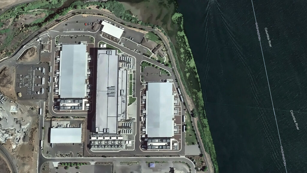
Every chip fabricated in a semiconductor plant needs ultrapure water. Most nuclear reactors need water as a coolant and neutron moderator. Every artificial intelligence (AI) data center drinks between 1 million and 5 million gallons of water a day, with thirst often peaking during drought.
Water runs through every technology priority the United States has named, yet the word does not appear once in “Launching the Genesis Mission,” an executive order (EO) released in November 2025. As described in the EO, the Genesis Mission is a “dedicated, coordinated national effort to unleash a new age of AI-accelerated innovation and discovery that can solve the most challenging problems of this century.”
Led by the Department of Energy (DOE), the initiative aims to build an integrated AI framework that would harness federal scientific datasets to accelerate breakthroughs in advanced manufacturing, biotechnology, critical materials, nuclear fission and fusion energy, quantum information science, and semiconductor development. The scope of the mission is comparable to that of the Manhattan Project.
Since the announcement, the DOE has listed “Predicting U.S. Water for Energy” among its 26 Genesis Mission Science and Technology Challenges. The project is also soliciting proposals in three water-related focus areas.
This framework provides a foothold for hydrology in the Genesis Mission, but it is scoped narrowly around water as a supply variable for energy production.
In reality, water is a crosscutting constraint that will help determine whether the mission’s priorities translate into deployable outcomes. The hydrology community now has a seat at the table, and if it moves first and positions water security as one of the “most challenging problems of this century,” the Genesis Mission can become the sandbox in which AI reshapes how the country measures, models, and manages water.
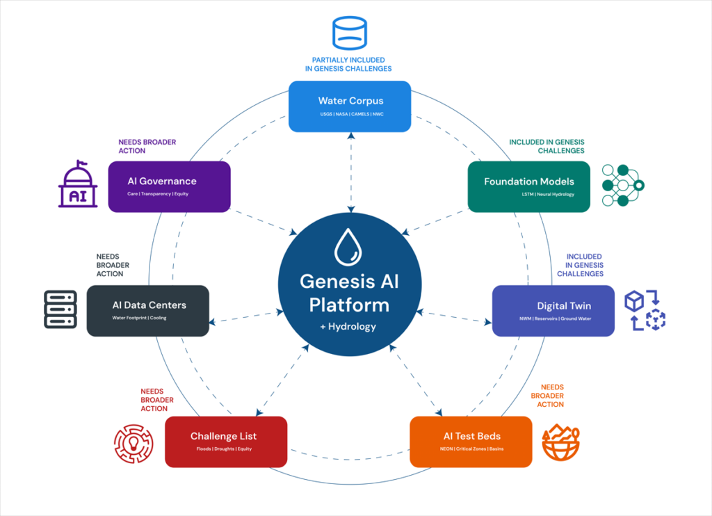
Making this happen will require that the DOE and the Office of Science and Technology Policy charter a hydrology workstream inside the Genesis Mission, with interagency delivery involving the U.S. Geological Survey (USGS), NOAA, the Bureau of Reclamation, the EPA, and partners at state, regional, and community levels. Here is what we think that workstream should look like:
A water-centric Genesis Mission architecture supports seven hydrological components that both feed into and receive decisions from the Genesis AI platform. Each component maps to a section of this article. Credit: Amobichukwu C. Amanambu. Click image for larger version.
While the existing challenges reflect some of these components, others will require coordinated effort from the hydrology community to bring into the Genesis Mission’s scope.
Build the Water Corpus Genesis Will Need
The Genesis Mission EO instructs the DOE to create an American Science and Security Platform to provide the public, scientists, agencies, and policymakers access to crucial scientific datasets.
The good news is that accessible water data systems already exist across several federal agencies and academic research centers. The USGS National Water Information System tracks real-time and historical water quality and use across the country. NASA’s Earth Science Data Systems Program provides open access to Earth science observations. NOAA’s National Water Center, the first federal facility dedicated to national water resource forecasting, operates the National Water Model, which continuously forecasts flows on 2.7 million stream reaches across the continental United States. The Catchment Attributes and Meteorology for Large-Sample Studies (CAMELS) dataset, currently hosted by the National Center for Atmospheric Research, provides data tailored for hydrological research on hundreds of river basins, and the Caravan framework pulls together multiple large-sample meteorological and hydrological datasets at a global scale.
What is missing is a unified, AI-ready repository that brings federal, state, and community data together.
What is missing is a unified, AI-ready repository that brings federal, state, and community data together. Building one is hard. Water data are fragmented, inconsistent, and often entirely absent. Consistent, reliable data for groundwater, withdrawals, reservoir operations, and water quality are especially difficult to obtain.
Local resistance to sharing data is real. In Texas, for example, landowners hold private property rights over groundwater and have opposed metering and reporting requirements imposed by groundwater conservation districts. In California, agricultural well owners fought metering mandates for years before the Sustainable Groundwater Management Act compelled local agencies to begin tracking withdrawals. Tribal nations face a different concern: Water data collected on Indigenous lands has been misrepresented in federal datasets that were modeled without accounting for Indian country, leading many nations to restrict access to their data as an exercise of sovereignty.
Practical steps toward building a unified AI-ready repository include tiered access and licensing for different stakeholders, clear provenance tracking for all data reported, financial and educational incentives for stakeholders for reporting, and targeted gap filling. Where measurements are missing, AI can fuse remote sensing with gauged records and operational logs—but only if the results carry honest uncertainty estimates tied to real decisions.
Get the corpus right, and it will outlive any single program name. It becomes infrastructure the country can lean on.
Develop Shared Hydrologic Foundation Models
The Genesis Mission EO directs the DOE to provide “domain-specific foundation models across the range of scientific domains covered.”
Hydrology has a head start. Long short-term memory (LSTM) networks are a key type of neural network designed to last thousands of time steps. Hydrology LSTMs trained on CAMELS data have already matched traditional conceptual models for daily streamflow discharge prediction. Open-source Neural Hydrology tools serve as baselines for regional runoff prediction. These predictions may serve as precursors to the foundation models the Genesis Mission envisions and building blocks from which they could be developed.
The process of scaling up these tools is not straightforward, however. A hydrologic investigation of snowmelt-driven streams in Colorado will not require the same spatiotemporal data as tile-drained fields in Iowa, for example. A hydrology-specific foundation model must take nuanced requirements into consideration and provide a clear path for managing and exploiting a variety of datasets.
Google’s Flood Hub shows what is possible: Its AI-enabled flood forecasts now cover more than 80 countries. However, Flood Hub’s core model code and trained weights remain proprietary, meaning researchers can use the forecasts but cannot rebuild or adapt the underlying models. Genesis, if well positioned, can fill that accessibility gap by producing foundation models for water that are reusable, reliable, and openly governed.
Build a National Water Digital Twin
The EO prescribes an integrated AI platform combining foundation models with simulation tools to stimulate AI-enabled innovations.
That architecture is exactly what a digital twin requires. Europe’s Destination Earth initiative is already building digital twins for weather extremes and nonstationary conditions on the Large Unified Modern Infrastructure (LUMI) supercomputer. The United Nations–led AI for Good initiative has prioritized water applications, warning that fragmented national efforts risk duplicating work.
If the United States aims for global strategic leadership in AI-accelerated science, water infrastructure cannot be an afterthought.
A water digital twin earns its keep when it makes the consequences of choices visible, in terms of flows, levels, temperatures, and risks to people and ecosystems.
Rather than starting from scratch, a water-centric Genesis Mission would unite existing federal models—the National Water Model, reservoir simulators, and groundwater codes—in a single digital twin. AI can become the thread that stitches them together, correcting biases and providing numerical solvers to enforce mass and energy balance.
What should this twin actually do? Help a dam operator decide whether to release water ahead of a storm. Tell planners where a new data center can draw cooling water without drying up a stream. Flag which coastal defenses will fail first under rising seas.
A water digital twin earns its keep when it makes the consequences of choices visible, in terms of flows, levels, temperatures, and risks to people and ecosystems.
Turn Basins into AI Test Beds
The Genesis Mission promotes AI-directed experimentation and directs the DOE to keep a record of robotic laboratories and production facilities in which such experimentation could be conducted. Hydrological field sites belong in that inventory. The National Ecological Observatory Network already operates 81 sites with standardized measurements of meteorology, surface water, groundwater, and biodiversity. The Critical Zone Collaborative Network instruments catchments to track water-soil-vegetation interactions over decades.
Formalizing these networks as AI test beds would link field observations back into the water digital twin so that experiments and models continually sharpen each other. Imagine mobile sensors steered by AI agents during a storm or aquifer recharge experiments designed by algorithms and verified in real time. That feedback loop is what separates a useful model from a decorative one.
Expand Water Challenges on the Genesis Mission List
The Exchange and What’s at Stake
Allowing water security to flow through the diverse components of the Genesis Mission would benefit both the policies championed by the mission itself and the hydrology community.
The Genesis Mission gets real-world, noisy test beds where AI proves value beyond benchmarks, a domain to stress test climate and infrastructure investments, and scientists trained in both AI and the stubborn realities of rivers, aquifers, and pipes.
Hydrology gets resources for shared data infrastructure, foundation models and instrumented basins no single lab can support, a seat when rules for AI and national scientific infrastructure are negotiated, and a chance to reset practices around openness, collaboration, and equity.
Earlier this year, the DOE released 26 Genesis Mission Science and Technology Challenges, and “Predicting U.S. Water for Energy” was among them. The accompanying funding call (DE-FOA-0003612) solicits proposals on cloud microphysics, coupled surface water–groundwater modeling, and seasonal to multiyear prediction, all framed around energy needs and flood resilience.
These inclusions are a significant win for a hydrology component to Genesis, but several urgent challenges sit outside their scope. Can AI close the gap between a flood forecast issued 12 hours out and the 48 hours emergency managers actually need? Can it map compound extremes, in which drought, heat, and infrastructure failure collide in the same week? Can it redesign monitoring networks so that coverage follows risk rather than where gauges happened to be installed a century ago? Integrating energy and water systems is equally urgent: Floods have caused 80% of major U.S. grid outages since 2000, while drought-driven water stress curtails cooling at thermoelectric plants and reduces hydropower output, exposing how deeply energy infrastructure depends on hydrologic extremes.
The water footprint of new AI infrastructure deserves a place on that list. A separate executive order (14318, “Accelerating Federal Permitting of Data Center Infrastructure”) is already fast-tracking expansion of data center construction, and a single hyperscale facility can consume 1 million to 5 million gallons of water daily. Emerging research shows how withdrawals at that scale can push streams below ecological thresholds during low flows.
Make Hydrology the Conscience of AI Governance
The EO directs the DOE to set data access rules and clarify policies for ownership, licensing, trade secret protections, and commercialization of products and tools associated with it.
Three principles should anchor such policies for AI use in water security.
First, Indigenous and community data rights must be embedded in every major AI water security effort, in line with the collective benefit, authority to control, responsibility, and ethics (CARE) principles for Indigenous data governance.
Second, AI’s own water footprint, through electricity generation and cooling, must be treated as a design constraint. Transparent reporting, stress-based siting, and efficiency targets will prevent hydrology in Genesis from being self-defeating.
Third, the DOE should define what failure looks like. Missing a flood crest portends loss of lives and livelihoods and breaches of treaties. Accountability standards must be measurable, and they must ask not just how accurate the forecast was on average, but who bore the cost when it was wrong.
A single executive order will not solve the country’s water security problems, and a single challenge topic will not either.
But the Genesis Mission has provided a seat at a table that did not exist 6 months ago. Whether the hydrology community treats it as a ceiling or a foundation depends on what happens next. Europe’s Destination Earth and the United Nations’ AI for Good water initiatives are already moving.
American hydrology now has a seat at the table. We should take it.
Kratzert, F., et al. (2019), Toward improved predictions in ungauged basins: Exploiting the power of machine learning, Water Resour. Res., 55, 11,344–11,354, https://doi.org/10.1029/2019WR026065.
Xiao, T., et al. (2025), Environmental impact and net-zero pathways for sustainable artificial intelligence servers in the USA, Nat. Sustainability, 8, 1,541–1,553, https://doi.org/10.1038/s41893-025-01681-y.
Zhang, L., et al. (2025), Foundation models as assistive tools in hydrometeorology: Opportunities, challenges, and perspectives, Water Resour. Res., 61, e2024WR039553, https://doi.org/10.1029/2024WR039553.
Author Information
Amobichukwu C. Amanambu (acamanambu@ua.edu), Department of Geography and the Environment, The University of Alabama, Tuscaloosa; and Jonathan Frame (jmframe@ua.edu), Department of Geological Sciences, The University of Alabama, Tuscaloosa
Citation: Amanambu, A. C., and J. Frame (2026), The Genesis Mission needs hydrology: Here’s how to incorporate it, Eos, 107, https://doi.org/10.1029/2026EO260131. Published on 28 April 2026.
This article does not represent the opinion of AGU, Eos, or any of its affiliates. It is solely the opinion of the author(s).
“Future winters promise less snow, more rain. Nobody’s prepared.” So proclaims the title of a recent article in the Proceedings of the National Academy of Sciences of the United States of America that frames adaptation to snow loss as the “million-dollar question” facing the western United States.
As the largest sectoral consumer of fresh water globally, agriculture is particularly vulnerable to snow loss.
Declining snowfall—and snowmelt—affects ecosystems, urban and rural water supplies, hydropower, recreation, tourism, and agriculture. As the largest sectoral consumer of fresh water globally, agriculture is particularly vulnerable to snow loss.
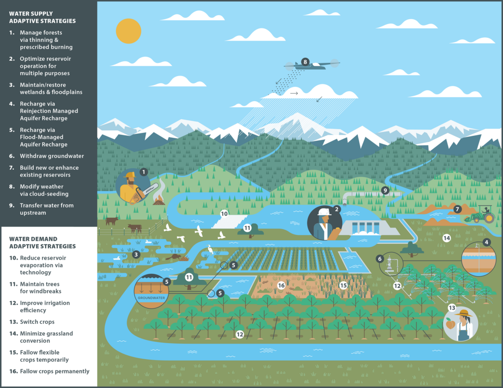
In response, water managers have developed a range of approaches for adapting to snow loss: infrastructure-based approaches like managed aquifer recharge, nature-based solutions such as forest management and beaver dam analogues, demand-side approaches like multibenefit land repurposing, and polarizing supply-side approaches like reservoir expansion and cloud seeding (Figure 1).
Fig. 1. Potential approaches to reduce negative impacts to agriculture from snow loss include a variety of adaptive strategies that address either water supply or demand. Click image for larger version.
However, efforts to identify which of these strategies to implement for different drainage basins, or watersheds, using the variety of available approaches seem to fall into one of two traps: either searching for unrealistic one-size-fits-all panaceas [Ostrom, 2007] or treating every basin as unique, which is costly and inefficient.
The “trillion-dollar question” isn’t how to adapt but, rather, where existing strategies may make the most—and fastest—difference.
Importantly, continuing along this trajectory means that we’re on track to offset only about a third of global climate-induced crop yield losses by 2100. For the western United States, previous work has estimated cumulative economic losses from declining snowfall of hundreds of billions to trillions of dollars while noting that rational adaptation decisions are hampered by the lack of financial analyses of the importance of snow [Sturm et al., 2017].
We thus suggest that the “trillion-dollar question” isn’t how to adapt but, rather, where existing strategies may make the most—and fastest—difference to offset projected losses. Answering this question requires an approach that matches strategies to the contexts where they are more likely to succeed—one that treats basins as neither uniform nor unique.
A Mismatch in Research and Operational Scales
Physical scientists tend to look at snow loss as a basin-scale problem, in part because this view aligns with hydrologic boundaries. However, as our colleague, applied economist Joey Blumberg, explains, “county lines were not drawn to follow watersheds, and rivers do not conform to political borders, creating a patchwork of mismatched boundaries.”
Scientists have long emphasized that mitigating climate change requires us to “think globally, assess regionally, act locally.” And in 1992, the authors of the Dublin Principles reasoned that moving the needle on “wicked water problems” requires targeting decisionmaking at the “lowest appropriate level,” where stakeholders can collaborate most effectively.
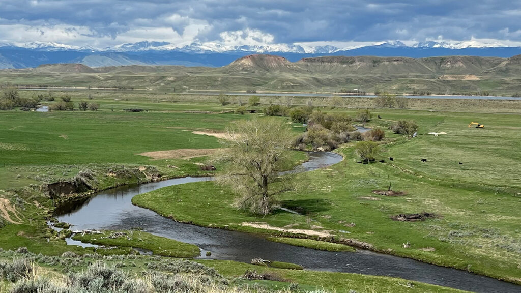
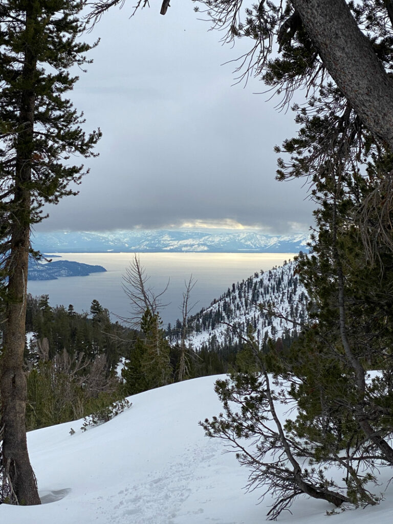
Lake Tahoe, pictured here, contains 37 trillion gallons of water, roughly half of which is supplied by snowmelt in the Sierra Nevada Mountains. Credit: Beatrice L. Gordon
Working at this scale, we found one-size-fits-all strategies often don’t hold up, even within the same hydrologic basin [Gordon et al., 2024; Boisramé et al., 2026]. In the Upper Colorado River Basin, for example, expanding reservoir storage could buffer agriculture in northeastern Utah against declining snowpack, but the same strategy may fail miles away in southwestern Wyoming, where a thirstier atmosphere may make it harder to refill existing reservoirs.
However, collecting detailed local-scale information for just 13 of the roughly 2,600 operational contexts nationwide took almost 3 years of searching websites, reading working papers, and calling water managers.
Scaling this approach across the entire western United States is understandably overwhelming. We need a more systematic approach to help managers identify which strategies could work most effectively, and where.
A Diagnostic for Agriculture and Snow Loss
Ostrom [2007] argued that complex systems, such as Western agriculture, “are partially decomposable in their structure.” This insight is woven into archetype analysis, an approach for identifying recurrent patterns across otherwise diverse systems.
Like workplace assessments—which are genuinely useful, albeit imperfect, tools for understanding successful management styles—archetypes draw on qualitative, quantitative, or hybrid approaches to group diverse operational contexts on the basis of shared characteristics [Sietz et al., 2019]. These groupings enable systematic knowledge transfer about, for example, how management strategies that work in one context can also guide adaptation elsewhere.
Three main characteristics interact to define operational contexts in snow-dependent agriculture in the western United States: physical constraints, governance systems, and human behavior.
“Researchers can empirically derive building blocks or components that comprise archetypes to represent key features of a system,” explains Elizabeth Koebele, who studies urban water sustainability [Garcia et al., 2019] and has begun applying archetypes in that context. However, she notes, these building blocks “vary based on the system context, available data, and study goal.”
We propose three main characteristics that interact to define operational contexts in snow-dependent agriculture in the western United States: physical constraints, governance systems, and human behavior. Physical constraints, including biophysical setting, infrastructure, and climate, determine available water supplies. Governance capacity relative to governance complexity shapes how those supplies are allocated across competing uses. Human behaviors influence both water demand and how users respond to supply conditions and governance rules.
Using these characteristics to establish archetypes of water management contexts could define a path forward for operationalizing an approach to accelerate successful adaptations to declining snowpacks in the West.
Constraining How Snowmelt Becomes Water Supply
Physical constraints stem from biophysical processes that influence how, when, and how much snow becomes streamflow; infrastructure that stores and conveys water; and hydrologic and climatic uncertainties about future supplies. These constraints can vary substantially from basin to basin.
Consider the Walker River Basin and California’s San Joaquin Valley, both of which rely on Sierra Nevada snowpack but have different biophysical settings. In some parts of the central Sierra, forest management can reduce wildfire risk and increase streamflow by up to 14% during low-snow years. Elsewhere, however, water made available by forest management may be consumed by remaining vegetation, limiting downstream gains.
These biophysical differences interact with uses of built infrastructure, including irrigation systems, reservoir outlets, and canals, to determine how and when water is stored and released. As temperatures warm and snowmelt declines, officials in both the Walker River and San Joaquin Valley basins must increasingly manage for a wider range of extremes, including “cold-water droughts.” However, the infrastructure to manage these trade-offs through reservoir storage and operations that balance agricultural deliveries with aquatic habitat needs is more developed in the highly managed San Joaquin than in the Walker.
Thankfully, measuring physical constraints on snowmelt at basin scales is becoming more feasible today with newly developed tools.
Layered on top of biophysical and infrastructural constraints are climatic and hydrological uncertainties, such as whether snow loss will lead to more evapotranspiration and less streamflow. These uncertainties complicate management decisions based on cost-benefit modeling of individual strategies: Should districts expand reservoir storage if precipitation is predicted to increase or decrease depending on the model? Frameworks like Decision Making Under Deep Uncertainty emphasize the need to select strategies that are robust across many possible futures.
Thankfully, measuring physical constraints on snowmelt at basin scales—a means, along with improved modeling, to reduce hydroclimatic uncertainties—is becoming more feasible today with newly developed tools. Water managers can turn, for example, to databases like the U.S. Geological Survey’s ResOpsUS [Steyaert et al., 2022], which catalogs historical reservoir operations across the contiguous United States, and to publicly available hydrologic projections such as those from Oak Ridge National Laboratory’s Coupled Models Intercomparison Project phase 6 (CMIP6) ensemble.
Governance Controls Supply Allocations
We frame governance around capacity and complexity. Capacity in this context is the ability of stakeholders “to mobilize resources in order to make equitable and fair decisions around shared challenges,” according to governance scholar Gina Gilson. Complexity refers to the number and intricacy of jurisdictions, authorities, regulations, and stakeholders involved. As governance complexity increases, the effectiveness of adaptation strategies becomes more sensitive to capacity constraints, particularly regarding timescales and funding.
For example, infrastructure in the Walker is controlled locally by a single water district, and jurisdictional coordination involves two states and the Walker River Paiute Tribe. Coordination on water management is never simple, but fewer jurisdictions generally means faster decisionmaking and clearer authority, allowing the single water district to implement strategies like multibenefit land repurposing more readily. Such implementations, in turn, enable reduced agricultural water use, directly supporting restoration of Walker Lake and recovery of endangered species.
The San Joaquin Valley is vastly different in scale and complexity, covering eight California counties, one of which alone has 22 water districts and seven cities. Following the passage of the state’s Sustainable Groundwater Management Act, water users in the basin formed more than 120 groundwater sustainability agencies. Agricultural water management thus involves overlapping federal and state systems that operate under different rules, contracts, and regulatory requirements. Whileland repurposing programs can be implemented, more substantial capacity, time, and resources are typically needed to do so.
Emerging efforts like the Western States Water Data Access and Analysis Tool (WestDAAT) and the Harmonized Database of Western U.S. Water Rights make it easier to assess governance in a basin by standardizing data about rules, regulations, and water rights across states. Combined with mapping of irrigation service areas and water transfers [Siddik et al., 2023], these resources help stakeholders identify the jurisdictions involved, how authority is distributed, and what coordination mechanisms exist for agricultural water management.
Human Behavior Shapes Demand Responses
Once snowmelt reaches water users, behavioral dynamics—how people respond to crises, policies, and changing conditions—determine how effectively management strategies achieve desired results.
Water demand is influenced by consumption choices and by economic, political, and cultural factors.
Water demand is influenced by consumption choices and by economic, political, and cultural factors. It is also influenced by factors that typical hydrologic models rarely account for, including social structure, social memory, and affluence. More affluent users are less likely to modify their behavior to reduce water use under conditions of scarcity.
The dynamics of water demand in the South Platte River Basin, for example, are especially complex, as they are balanced across cities, agriculture, and ecosystems across parts of Colorado, Nebraska, and Wyoming. Water prices in the basin’s Big Thompson project, a federal water diversion system in northern Colorado, jumped from $1,500 per acre-foot in 1990 to more than $30,000 in 2018, driven by economic factors that resulted in cities owning 70% of water originally intended for agriculture.
Even with reliable projections of future climate and water supply, carefully planned strategies can be overwhelmed by economic and behavioral factors, resulting in transfers and reallocations of water. What’s more, behavioral responses to adaptation strategies can paradoxically increase demand when users perceive that scarcity problems are solved.
The “reservoir effect” occurs when water security perceptions encourage expansion of water-intensive activities [Di Baldassarre et al., 2018]. Similarly, the irrigation efficiency paradox shows how efficiency gains can lead to expanded production and reduced return flows (how much irrigation water returns to streams and aquifers) downstream [Grafton et al., 2018].
Conceptual frameworks, models, and global case studies have all been used as approaches to study the effects of human behavior on hydrology. With sufficient training data, we believe tools like machine learning could be used to further explore how behaviors influence adaptation and to anticipate shifts as snow loss continues.
Archetypes in Practice
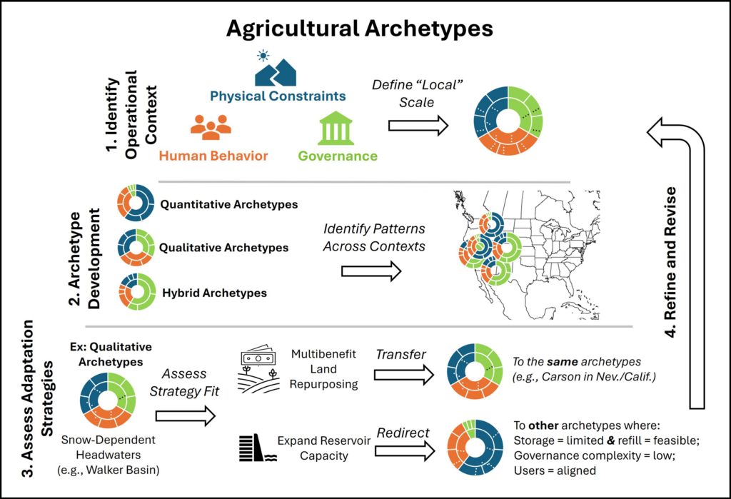
By evaluating how physical factors, governance systems, and human behavior shape outcomes across places like the Walker, South Platte, and San Joaquin basins, researchers and practitioners can establish archetypes to help identify patterns in what strategies are most effective in different places and assess how to transfer lessons from one setting to another (Figure 2).
Fig. 2. An archetype-based diagnostic grounded in evaluating the physical constraints, governance, and human behavioral dynamics affecting hydrologic basins could facilitate more rapid transfer of learning about successful adaptation approaches across snowmelt-dependent agriculture in the western United States.
The Walker River Basin exemplifies an archetype common to agriculturally dominated headwaters in the western United States with low governance complexity (few jurisdictions), adequate capacity (resources), low behavioral complexity (more predictable and unified user groups), and substantial physical constraints (significant future snow loss and limited infrastructure for water storage and supplementation).
With this profile, the Walker is an ideal testing ground for evaluating how effectively different strategies offset changes in snowmelt. Does cloud seeding increase snowpack? Could beaver dam analogues—a nature-based solution reminiscent of Idaho Fish and Game’s mid-20th century effort to parachute beavers into the wilderness—meaningfully increase water retention? Could multibenefit land repurposing buffer people and ecosystems against supply volatility while restoring ecosystem functionality?
The value of organizing operational contexts by archetypes is that each context need not be treated as unique.
The value of organizing operational contexts by archetypes is that each context need not be treated as unique. Lessons learned from the Walker could be systematically transferred to other areas with similar characteristics and could be incrementally tested in others.
The South Platte has physical constraints similar to Walker’s but features greater governance complexity because of multiple interstate compacts, as well as greater behavioral complexity. Modeling analyses indicate that demand-side strategies could adapt to more volatile water supply in the South Platte [Gharib et al., 2023]. But implementing them requires balancing perspectives from both agricultural and urban water users—a behavioral dynamic absent in Walker.
Crop switching to cultivate higher-value crops on less acreage could reduce water use. However, options for what crops can be grown where are constrained by factors like elevation and climate. Even where feasible, new crops would require investments in education, new infrastructure, risk management, and agronomic knowledge.
Through iterative expansion and testing, broad archetypes like “high behavioral complexity” could be specified to reflect dynamics like rural-urban competition or concerns around buy-and-dry economics. Archetypes may also point to contexts where governance complexity signals that decisionmaking is occurring above the lowest appropriate level.
The San Joaquin, with its extremely complex governance involving numerous local, state, and federal agencies managing surface and groundwater, is one potential example. Recognizing this pattern can help identify where substantial resources and long timelines may be required to implement programs (e.g., LandFlex) requiring legislative authorization, multiagency coordination, and stakeholder engagement. It may also signal the need to identify smaller operational contexts within larger settings so implementations proceed more rapidly.
Operationalizing Archetypes from Diagnosis to Action
Developing a systematic approach to match adaptation strategies with areas where they are most likely to succeed in operation is only a first step. Applying diagnostics without mechanisms to implement new strategies is often insufficient to drive timely action.
An instructive precedent of success in water quality management comes from the 1970s. By then, pollution controls on factories had improved compared with the early 20th century, yet water quality in surface waters across the country still declined because of pollution in agricultural runoff. The breakthrough came with the EPA’s total maximum daily load (TMDL) program, which created a structured process that set measurable goals for reducing pollution and assigned responsibility for meeting those goals to the sources of the pollution, allowing for local control over adaptation.
Archetypes could play a similar role in facilitating beneficial snow-loss adaptations, and a structure like the TMDL program could start by assessing supply-demand risks across operational areas, setting performance targets such as reservoir reliability and shortage frequency, and then using the diagnostic to identify which strategies fit each archetype. Results and lessons could be shared region-wide, while implementation would remain locally driven.
This suggestion is, emphatically, not a prescription for specific policy mechanisms. But it serves as a reminder that—just as few of us engage with workplace assessments or change behavior on the basis of their results without organizational support—archetypes will need to be paired with implementation structures to translate diagnosis into action.
Beyond Silver Bullets
There is no single answer to our trillion-dollar question, but one path forward for sustaining complex Western ecosystems lies in developing archetypes of different types of basins.
Nearly 20 years ago, Ostrom [2007] warned against seeking panaceas for complex environmental problems. There is no silver bullet for snow loss or single answer to our trillion-dollar question, but one path forward for sustaining complex Western ecosystems lies in developing archetypes of different types of basins.
A small irrigation district, for example, wouldn’t need to independently test every strategy in Figure 1 or develop complex decision support tools when a similar archetype already evaluated which strategies work under comparable governance, behavioral, and physical conditions.
Critically, these archetypes can be developed and refined by managers and scientists to capture more nuanced realities. Physically constrained systems, for example, could include areas facing high future uncertainty or limited reservoir flexibility. Governance and behavioral dimensions could likewise evolve to represent contexts where subsidies lead to incoherent incentives or where cultural norms link water use to local identities and traditions.
Like workplace assessments, the goal isn’t to diminish unique personalities but to work with them more strategically. Archetypes can show where we don’t need to reinvent the wheel to adapt and where the wheel might need to be tweaked. By leveraging collective knowledge and learning across regions facing similar challenges, rather than crafting new solutions basin by basin, we can reduce the time and resources needed to implement equitable and sustainable adaptation solutions.
Acknowledgments
This work is supported by the National Science Foundation (NSF) under grants 1828902 and OIA-2148788. Where We Live is funded by a grant from NSF’s Established Program to Stimulate Competitive Research (EPSCoR) RII Track-2 program and features partnerships across the University of Idaho (award 2316126); the University of Nevada, Reno (award 2316127); and the University of South Carolina (award 2316128). Work was also supported by internal funds from the Division of Hydrologic Resources at the Desert Research Institute.
References
Boisramé, G. F., et al. (2026), Think globally, model locally: Complex responses of agricultural water supplies to different climate projections, J. Am. Water Resour. Assoc., 62(3), e70117, https://doi.org/10.1111/1752-1688.70117.
Garcia, M., et al. (2019), Towards urban water sustainability: Analyzing management transitions in Miami, Las Vegas, and Los Angeles, Global Environ. Change, 58, 101967, https://doi.org/10.1016/j.gloenvcha.2019.101967.
Gharib, A. A., et al. (2023), Assessment of vulnerability to water shortage in semi-arid river basins: The value of demand reduction and storage capacity, Sci. Total Environ., 871, 161964, https://doi.org/10.1016/j.scitotenv.2023.161964.
Gordon, B. L., et al. (2024), The essential role of local context in shaping risk and risk reduction strategies for snowmelt‐dependent irrigated agriculture, Earth’s Future, 12(6), e2024EF004577, https://doi.org/10.1029/2024EF004577.
Ostrom, E. (2007), A diagnostic approach for going beyond panaceas, Proc. Natl. Acad. Sci. U. S. A., 104(39), 15,181–15,187, https://doi.org/10.1073/pnas.0702288104.
Sietz, D., et al. (2019), Archetype analysis in sustainability research: Methodological portfolio and analytical frontiers, Ecol. Soc., 24(3), 34, www.jstor.org/stable/26796999.
Steyaert, J. C., et al. (2022), ResOpsUS, a dataset of historical reservoir operations in the contiguous United States, Sci. Data, 9, 34, https://doi.org/10.1038/s41597-022-01134-7.
Sturm, M., et al. (2017), Water and life from snow: A trillion dollar science question, Water Resour. Res., 53(5), 3,534–3,544, https://doi.org/10.1002/2017WR020840.
Author Information
Beatrice L. Gordon (beatrice.gordon@dri.edu), Gabrielle F. S. Boisrame, Christine M. Albano, and Rosemary W. H. Carroll, Desert Research Institute, Reno, Nev.; and Adrian A. Harpold, University of Nevada, Reno
Citation: Gordon, B. L., G. F. S. Boisrame, C. M. Albano, R. W. H. Carroll, and A. A. Harpold (2026), Archetypes could accelerate agricultural adaptation to less snowpack, Eos, 107, https://doi.org/10.1029/2026EO260184. Published on 9 June 2026.
This article does not represent the opinion of AGU, Eos, or any of its affiliates. It is solely the opinion of the author(s).