Editors’ Highlights are summaries of recent papers by AGU’s journal editors.
Source: Tectonics
At subduction zones, one tectonic plate dives beneath another, dragging rocks tens of kilometers into Earth’s interior where they are transformed by extreme pressures and temperatures. Some of these deeply buried rocks make it back to the surface, carrying a record of conditions along the plate boundary at depth. Geologists have long debated how these high-pressure rocks are exhumed and how they
At subduction zones, one tectonic plate dives beneath another, dragging rocks tens of kilometers into Earth’s interior where they are transformed by extreme pressures and temperatures. Some of these deeply buried rocks make it back to the surface, carrying a record of conditions along the plate boundary at depth. Geologists have long debated how these high-pressure rocks are exhumed and how they end up mixed into younger, lower-grade surrounding material.
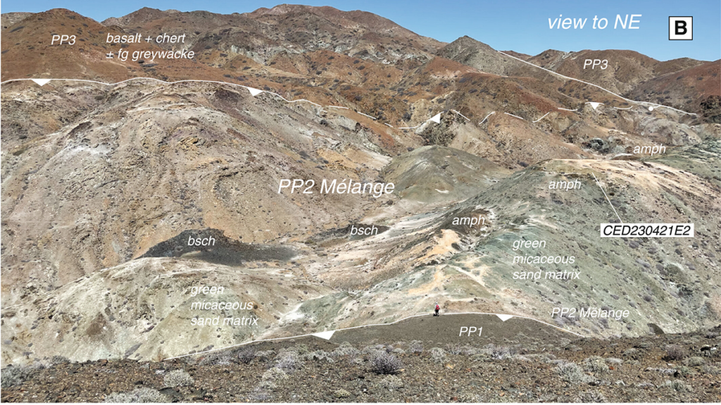
Wang et al. [2026] address this question with detailed geologic mapping, Ar-Ar analyses, and U-Pb geochronology from subduction complex rocks on Cedros Island, offshore Baja California, Mexico. Their data show that high-pressure blocks yield cooling ages between 172 and 144 million years old, yet they are hosted in sedimentary rocks no older than about 92 million years. This age mismatch, combined with field evidence that the blocks are enveloped in sedimentary matrix rather than tectonically sheared into place, leads the authors to propose that the high-pressure rocks were exhumed to the surface, eroded, and recycled back into the subduction trench as sedimentary debris, potentially multiple times. The authors suggest that rapid exhumation was driven by extension within the forearc wedge. When plate convergence rates dropped abruptly, the wedge became gravitationally unstable and stretched along brittle-ductile shear zones, bringing deeply buried rocks to shallow crustal levels.
This polycyclic model is incompatible with alternative interpretations in which exotic blocks were mixed into their host matrix by viscous return flow within the subduction channel, because such models predict that blocks and their surrounding matrix should share similar thermal histories. Instead, the data require that blocks completed their journey to depth and back long before the surrounding sediments even entered the trench. The new understanding of subduction dynamics on Cedros Islands illuminates connections with the broader Franciscan Complex of California, where the origin of similar high-pressure blocks in younger matrix has been debated for decades. Together, these findings offer new perspectives on how subduction zones operate over long timescales and how their fragmentary rock record preserves fundamental evidence of the tectonic history of the continental margin.
Citation: Wang, J. W., Kapp, P., Holder, R., He, J., Hernández-Uribe, D., & Worthington, J. (2026). Polycyclic metamorphism, exhumation, and recycling of subduction complex rocks, Cedros Island, Baja California. Tectonics, 45, e2025TC009340. https://doi.org/10.1029/2025TC009340
Researchers have found that Earth’s underlying crust in the Turkana Rift region has been significantly thinned, presaging Africa’s eventual breakup—and with that finding, the researchers offer a new perspective on Turkana’s fossil record of human evolution.
Researchers have found that Earth’s underlying crust in the Turkana Rift region has been significantly thinned, presaging Africa’s eventual breakup—and with that finding, the researchers offer a new perspective on Turkana’s fossil record of human evolution.
For roughly 45 million years, the eastern section of the African continental plate has been slowly pulling apart. Like a giant zipper extending from the Red Sea to Mozambique, the East African Rift System will likely be home to new oceanic crust that will well up from the widening split in Earth’s surface. While most of the rifts in that system are still zipped shut, the Afar region in northern Ethiopia has already partially unzipped and may be starting to create a future ocean basin.
Most m
For roughly 45 million years, the eastern section of the African continental plate has been slowly pulling apart. Like a giant zipper extending from the Red Sea to Mozambique, the East African Rift System will likely be home to new oceanic crust that will well up from the widening split in Earth’s surface. While most of the rifts in that system are still zipped shut, the Afar region in northern Ethiopia has already partially unzipped and may be starting to create a future ocean basin.
Most models of this rift system suggest that it should continue to unzip sequentially from north to south. However, new research suggests that a region in the middle of the zipper is on the verge of splitting open.
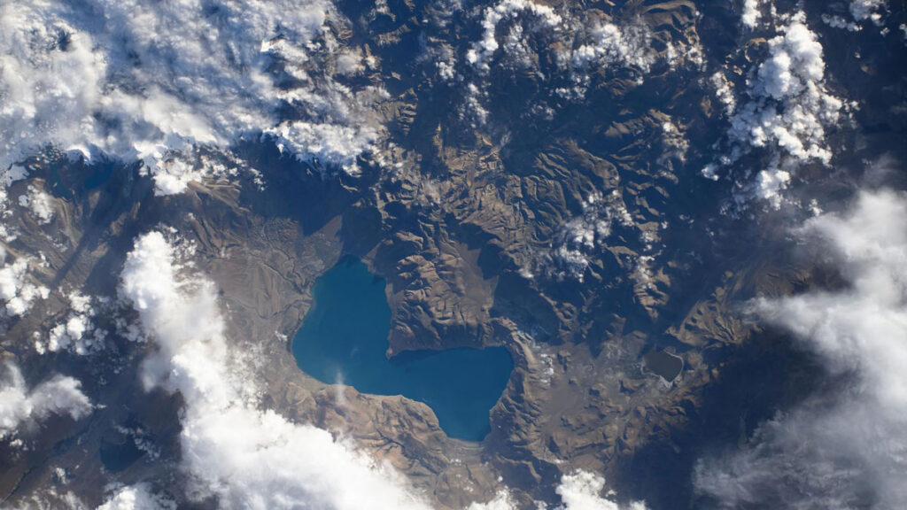
High-resolution seismic reflection data show that the crust near Kenya’s Lake Turkana is only 13 kilometers thick. This suggests that the region has entered the second stage of rifting, called necking, and is one step closer to breaking apart. It is the only rift zone on Earth currently undergoing this short-lived tectonic process.
The Lothagam site in the Turkana Rift Zone contains tilted sediments from the late Miocene (about 7 million years ago), just before the necking phase of rifting commenced. Credit: Christian Rowan
Breaking Up Is Hard to Do
Just like mid-ocean ridges on the seafloor, sections of Earth’s crust on land also stretch apart as tectonic plates separate. This process, called rifting, takes place in three stages. First, the crust stretches, creating tension. Then it rapidly thins like pulled taffy—this is the necking stage. Finally, magma wells up from the lithospheric mantle, which creates new seafloor and breaks the continental plate apart.
“This is one of the unique places on Earth where you can see a continental rift.”
Not every rift makes it that far. Some remain stuck in the stretching phase with crust more than 20 kilometers thick. But northern sections of the East African Rift System (EARS), specifically the Afar Rift and the Red Sea, are already undergoing the final stage, oceanization.
“This is one of the unique places on Earth where you can see a continental rift,” said Anne Bécel, a geophysicist at Lamont-Doherty Earth Observatory of Columbia University in Palisades, N.Y., and coauthor of new research published in Nature Communications in April. “The East African Rift System has been studied for a very long time by geologists to really learn about our planet and how continents break apart, and then transpose that to mid-ocean ridges where oceanic plates spread apart.”
The team suspected that the Turkana Rift Zone, located at a critical triple junction in northern Kenya, was behaving differently from other areas of the rift system. It is home to an unusually large and continuous hominin fossil record dating back about 4 million years. Past research has also shown that the bottom of the crust, called the Moho, is unusually shallow in the Turkana Basin, just 20 kilometers deep compared with the average depth of 39 kilometers farther away from the rift.
During several field expeditions to Lake Turkana in partnership with local industries, the team mapped the top of the continental crust using borehole measurements and seismic reflection—sending seismic waves into the ground and measuring how the waves bounce back, like sonar. They combined those measurements with past research into Moho depths to calculate the crustal thickness near Lake Turkana.
That map showed that far away from the rift, the crust is more than 35 kilometers thick, but in the Turkana Rift Zone it is a mere 13 kilometers thick, below the threshold for necking.
“If you look at the modern day topography, the whole East African Rift is in this really low, broad land between two big plateaus, one to the north in Ethiopia and one towards the south,” said lead researcher Christian Rowan, a geologist and doctoral candidate at Columbia University. “It’s this very strange topographic feature, and part of that low-lying topography is actually how thin the crust is there.”
“The oldest rocks that record the initiation of the East Africa Rift System are also in the Turkana Rift,” said coauthor Folarin Kolawole, a Columbia University geologist. Geochemical analysis of those rocks suggests that necking in the Turkana Rift Zone began about 4 million years ago.
Christian Rowan measures a fault in the Turkana Rift. Credit: Christian Rowan
About to Break?
“Any time you have a place on the planet that is rare in the modern but seen in the past, it is compelling,” said Erik Klemetti Gonzalez, a volcanologist at Denison University in Granville, Ohio, who was not involved with this research. “The data does show that the Turkana Rift is the home of anomalously thin continental crust, so if you are looking for a location that meets criteria for necking, it seems to be the case.”
The team suspects that Turkana might have been primed to split apart more easily because another rifting event took place there a mere 17 million years before the present rift began. The Turkana Basin inherited a weaker section of crust that didn’t have time to fully heal in the (geologically) short time between rifting events. There was also an extended period of magmatic activity throughout much of the past 45 million years.
“Magmatism is well known to be a significant weakening factor in rifting,” Rowan said. “I think the two compounding effects of this inheritance and then magnetism is why the Turkana rift is so much more mature than other segments.”
“I would hope that more collaboration with African geoscientists could create the ability to collect data from places that have been more inaccessible over the past half century.”
“There are many ‘failed rifts’ in the geologic record, so the question of whether the EARS is actually leading to a continental break up, albeit a small one, is still very much up in the air,” Klemetti Gonzalez said. These new results tip the scales toward breakup, but he noted that more of the rift system still needs to be mapped to really understand the fate of this region.
“I would hope that more collaboration with African geoscientists could create the ability to collect data from places that have been more inaccessible over the past half century,” he added.
Rowan and his team are working toward that end by continuing to map crustal thicknesses in other nearby rift zones.
“This was the only known rift that was undergoing necking along the entire East African Rift System, or in the world,” said Kolawole. “But based on ongoing work, there is evidence that there are other segments that are at the onset of necking in the East African Rift System.”
Citation: Cartier, K. M. S. (2026), Eastern Africa is splitting apart, but not where we expected, Eos, 107, https://doi.org/10.1029/2026EO260148. Published on 12 May 2026.
Source: Geophysical Research Letters
As seismic waves travel through Earth, they gradually lose energy, a process called attenuation. That energy loss doesn’t happen uniformly—some features in the crust sap far more energy from seismic waves than others. Researchers can map underground features by watching where seismic waves lose more or less energy. The Southern Array for the Lithosphere and Uplift of Taiwan Experiment (SALUTE) is doing just that, providing information that could lead to i
As seismic waves travel through Earth, they gradually lose energy, a process called attenuation. That energy loss doesn’t happen uniformly—some features in the crust sap far more energy from seismic waves than others. Researchers can map underground features by watching where seismic waves lose more or less energy. The Southern Array for the Lithosphere and Uplift of Taiwan Experiment (SALUTE) is doing just that, providing information that could lead to improved seismic hazard planning in the country.
Lin et al. report attenuation results from SALUTE focused on the convergence between the Eurasian plate and the Luzon Arc, an understudied, geologically dynamic area where Earth’s crust is deforming. Using the overall attenuation rate and relative attenuation rates of P and S seismic waves, the authors imaged active faults, identified distinct lithologies, and better resolved the Luzon forearc block that sits just offshore of Taiwan.
The authors used data from the SALUTE high-density seismographic network, spanning December 2020 to December 2023, to construct both 2D and 3D attenuation models. They found clear changes in attenuation associated with major faults, as well as areas of high attenuation associated with fluid-rich, ductile zones in the lower crust that cause tectonic tremors. Their attenuation imaging additionally revealed that the Luzon forearc block, which had been poorly imaged in the past, dips northward and narrows as it nears the convergence zone.
The authors say their results agree well with previous velocity-based seismic imaging studies and show that attenuation can image features, such as transition zones, that were previously difficult to capture. Their data could also be useful for better understanding seismic hazard throughout the region, they note. (Geophysical Research Letters,https://doi.org/10.1029/2025GL121583, 2026)
Citation: Scharping, N. (2026), Seismic attenuation techniques reveal what lies beneath Taiwan, Eos, 107, https://doi.org/10.1029/2026EO260150. Published on 11 May 2026.
Editors’ Highlights are summaries of recent papers by AGU’s journal editors.
Source: Tectonics
Scientific progress rarely follows a straight path. Instead, it develops through open discussion, critical evaluation, and the testing of new ideas. The exchange between authors and colleagues illustrates how this process unfolds in modern Earth sciences and provides a valuable example of constructive scientific debate.
At the center of the discussion lies a fundamental question about one of
Scientific progress rarely follows a straight path. Instead, it develops through open discussion, critical evaluation, and the testing of new ideas. The exchange between authors and colleagues illustrates how this process unfolds in modern Earth sciences and provides a valuable example of constructive scientific debate.
At the center of the discussion lies a fundamental question about one of Earth’s most remarkable geological features: how did the Himalaya and the Tibetan Plateau become the highest and largest mountain system on the planet?
In their paper “Raising the Roof of the World: Intra-Crustal Asian Mantle Supports the Himalayan–Tibetan Orogen,” Sternai et al. [2025] address this question using numerical geodynamic modeling. These computer simulations reproduce the physical behavior of large rock masses deep inside the Earth and allow researchers to investigate the long-term evolution of this vast orogenic system.
Their study specifically explores the possibility that, during the collision between the Indian and Asian plates, layers of mechanically strong Asian mantle rock became embedded within the thickened Indian continental crust beneath the Tibetan Plateau. According to this hypothesis, these mantle layers could help sustain the elevation of the Plateau by effectively withstanding stresses over long geological timescales: the Indian crust would provide buoyancy (raising the roof), while the Asian mantle would contribute mechanical strength to support the Himalayan–Tibetan topography.
Hetényi and Cattin disagree with and challenge this interpretation in their Comment. Drawing on a large body of well-established geophysical and geological observations, they argue that the structure beneath southern Tibet is better explained by underthrusting, the process by which the Indian plate slides beneath the Tibetan Plateau. Seismic imaging studies, including receiver-function analyses that use earthquake waves to map subsurface structures, consistently reveal features interpreted as Indian crust and upper mantle extending far north beneath Tibet.
In their Reply, Sternai and colleagues clarify that their models were not intended to accurately reproduce the present-day structure of the region in detail. Instead, they were designed as process-oriented experiments to test whether existing and/or alternative mechanisms for crustal thickening and plateau support are mechanically and rheologically viable.
This exchange highlights an important aspect of contemporary geoscience—observations of Earth’s interior such as seismic images, gravity data, and geological records often allow multiple, non-unique interpretations. Numerical modeling provides a complementary approach by evaluating whether proposed geological mechanisms are physically plausible.
Equally significant is the tone of the discussion itself. The Comment and Reply show how scientists, while strongly disagreeing about interpretations, can maintain a constructive and respectful dialogue. Such approach fuels scientific advance by encouraging the community to re-examine established assumptions, refine models, and integrate new observations.
Debates like this one, therefore, extend well beyond a specific geological question. They illustrate how scientific understanding advances through the interplay of observations, theoretical reasoning, and modeling experiments.
In this way, the dialogue highlighted here contributes not only to our understanding of the Himalayan–Tibetan mountain system but also to the broader methodology of Earth science.
Citations
Sternai, P., Pilia, S., Ghelichkhan, S., Bouilhol, P., Menant, A., Davies, D. R., et al. (2025). Raising the roof of the world: Intra-crustal Asian mantle supports the Himalayan-Tibetan orogen. Tectonics, 44, e2025TC009057. https://doi.org/10.1029/2025TC009057
Hetényi, G., & Cattin, R. (2026). Comment on “Raising the roof of the world: Intra-crustal Asian mantle supports the Himalayan-Tibetan orogen” by Sternai et al. Tectonics, 45, e2025TC009214. https://doi.org/10.1029/2025TC009214
Sternai, P., Pilia, S., Ghelichkhan, S., Bouilhol, P., Menant, A., Ostorero, L., et al. (2026). Reply to comment by Hetényi and Cattin on: “Raising the roof of the world: Intra-crustal Asian mantle supports the Himalayan-Tibetan orogen”. Tectonics, 45, e2026TC009436. https://doi.org/10.1029/2026TC009436
As the Indian and Eurasian continental plates collide, the Tibetan Plateau is slowly deforming. For decades, geoscientists debated how this deformation occurs: Is the plateau like a block of crumbly aged cheddar, deforming mostly at its faults, or is it more like French brie, moving like a very viscous liquid being pushed slowly to the east?
A new study published in Science shows that both theories are at work. The study’s findings provide the most comprehensive picture yet of the Tibetan Pl
As the Indian and Eurasian continental plates collide, the Tibetan Plateau is slowly deforming. For decades, geoscientists debated how this deformation occurs: Is the plateau like a block of crumbly aged cheddar, deforming mostly at its faults, or is it more like French brie, moving like a very viscous liquid being pushed slowly to the east?
A new study published in Science shows that both theories are at work. The study’s findings provide the most comprehensive picture yet of the Tibetan Plateau’s deformation and offer valuable information for earthquake hazard assessments in the region.
The new model that combines the two theories is a “significant advance,” said Eric Fielding, a geodesist who was not involved in the study. Fielding is a staff member at NASA’s Jet Propulsion Laboratory but did not speak on behalf of the agency. “It’s clearly the result of a very large amount of work,” he said.
A Deformation Investigation
For decades, scientists have held differing views on the Tibetan Plateau’s deformation. One camp modeled the plateau’s deformation with movement occurring mostly at its faults, while the other modeled the movement like a thick fluid deforming areas beyond faults.
“These two communities have carried on modeling deformation in different ways” and have never fully resolved the differences between their models, said Tim Wright, a geodesist at the University of Leeds in the United Kingdom and lead author of the new study.
It’s tricky to measure the plateau’s deformation, though, because it changes so slowly: One of the fastest faults on the plateau, the Kunlun Fault, moves at about just 10 millimeters per year. “These are rates that are less than your fingernails growing,” Wright said.
And because much of the Tibetan Plateau’s terrain is inaccessible, there’s a dearth of ground-based stations to track movement, meaning most geodetic data for the area must come from satellites.
“It’s a boon for science to have that consistent acquisition of the same kind of data for 10 years.”
Tracking such nearly imperceptible movement with satellites hundreds of kilometers above requires enormous amounts of data collected over many years. Wright and his colleagues finally had those data after 10 years of observations from the European Space Agency’s Sentinel-1 satellite mission, which launched in 2014.
“Because the signals are so small, you need to wait for some time before you accrue enough deformation that you can actually measure it,” Wright said. The 2014–2024 data they analyzed are “giving us a really clean signal,” he said.
“It’s a boon for science to have that consistent acquisition of the same kind of data for 10 years,” Fielding said.
Using tens of thousands of satellite images alongside ground-based satellite navigation system stations, Wright and the team constructed comprehensive velocity maps of the deformation of the plateau. Results showed that a mix of theories best describes the mechanism.
“We think what’s really happening is a combination of both,” Wright said.
Wright, who described himself as “formerly of the viscous deformation camp,” was surprised by the prominent role that faults played in the plateau’s deformation. Previously, he said, he would have described the faults as passive markers within the underlying flow of the landmass. But the data show that the faults influence a much broader area of the plateau: “The whole deformation of the plateau is influenced by those faults,” he said.
The study “shows clearly that these major fault systems are responsible for a large part of the strain within the plateau,” Fielding said.
Mapping Seismic Hazards
“We have very little information about the history of earthquakes on these faults in this area.”
Knowing how the plateau deforms can also help scientists create more accurate seismic hazard assessments for the millions of people who may be affected by earthquakes there, particularly at the edges of the plateau. “We have very little information about the history of earthquakes on these faults in this area,” Fielding said.
The research team is working with the Global Earthquake Model Foundation, a nonprofit earthquake research collaboration, and other organizations to incorporate their findings into hazard assessments.
Wright and the research team recently used a similar methodology to map the deformation field of the entire Alpine-Himalayan belt, which stretches from Spain to eastern China. The same methods could be used to map the deformation of the western United States, another area where both viscous and fault-related deformation may affect large population centers, Fielding said.
Citation: van Deelen, G. (2026), Weak faults play a strong role in the Tibetan Plateau’s deformation, Eos, 107, https://doi.org/10.1029/2026EO260162. Published on 22 May 2026.
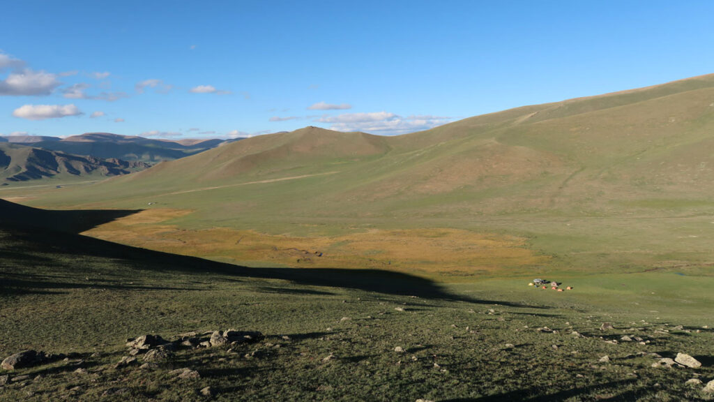
Central Mongolia’s Hangay Mountains have long posed a conundrum. Rising 4 kilometers above sea level, the dome-shaped range plays a key role in shaping the region’s climate. But it couldn’t have formed in the same way as most equally tall mountain ranges.
“These mountains in central Mongolia are very far from any plate boundary, about 3,000 kilometers away from the Pacific margin,” said Pengfei Li, a geologist at the Chinese Academy of Sciences’ Guangzhou Institute of Geochemistry. “
Central Mongolia’s Hangay Mountains have long posed a conundrum. Rising 4 kilometers above sea level, the dome-shaped range plays a key role in shaping the region’s climate. But it couldn’t have formed in the same way as most equally tall mountain ranges.
“These mountains in central Mongolia are very far from any plate boundary, about 3,000 kilometers away from the Pacific margin,” said Pengfei Li, a geologist at the Chinese Academy of Sciences’ Guangzhou Institute of Geochemistry. “It’s very hard to understand why we have such a mountain range so far from the plate boundary.”
Li recently led research finding that geochemical evidence supports a compelling explanation of how these oddball mountains formed. The researchers proposed that at the site of the future mountains, a U-shaped bend in a tectonic plate led to an extra-thick lithosphere. A chunk of that heavy lithosphere eventually broke off and sunk into the mantle. Free of the extra weight, the crust then rebounded upward as the Hangay Mountains.
Bend and Snap
“It’s the first discovery of volcanism for this period.”
Tectonic plates are far from rigid. As they move above, below, and against each other, sections of the plates far from the boundary can develop curves and folds like a scrunched up tablecloth. Curved sections, called oroclines, are common around the world. At about 6,000 kilometers long, the Mongolian orocline is one of the longest, and the Hangay Mountains sit right at the curviest part of the orocline’s U shape.
Li and his colleagues suspected that the Hangays’ location along the orocline is no coincidence. During multiple field expeditions from 2018 through 2026, the researchers collected rock samples from several sites in the Hangay Mountains that showed signs of ancient volcanic activity. Uranium-lead dating of zircons within those samples showed that the area experienced volcanic activity in the early Cretaceous period 124–114 million years ago.
“When I saw the age, I was surprised,” Li said. “120 million years—no one had ever reported volcanoes [in the Hangay Mountains] during this period.…It’s the first discovery of volcanism for this period.”
The team also analyzed the samples for major and trace elements to determine the depth at which the rocks formed. Their geochemical analysis revealed that the rocks formed in the lithosphere 80 kilometers below the surface. They published these results in Geology in April.
It’s pretty odd that the rocks originated so deep, Li said, because the modern-day lithosphere is only 70 kilometers thick.
The team proposed that when the continental plate folded and created the Mongolian orocline 200 million years ago, the lithosphere bunched up and became thicker in the curve of the U shape. That thicker section of lithosphere, a root at least 80 kilometers thick, would have been unstable in the long term, Li explained.
The lithospheric root would have been too heavy to remain attached to the crust above for long, and a chunk of it would have eventually snapped off. When it sunk, or foundered, into the deep mantle, it would have melted and generated the volcanic activity recorded in the rocks the team studied. Free from the weight of that lithospheric root, the crust above would have rebounded into the dome-shaped mountain range visible today.
Complicated Yet Compelling
“Their story, though complicated, makes a great deal of sense and in a way provides affirmation of a prediction made some time ago regarding oroclines.”
“The story that [the researchers] have put together to explain the massive Hangay topographic ‘dome’ of central west Mongolia is a compelling one that spans more than the past 200 million years of Earth history,” said Stephen Johnston, a tectonics researcher at the University of Alberta in Canada who was not involved with this research. Past research into the Iberian orocline suggested that oroclines might lead to lithospheric thickening, and this explanation of the Hangay Mountains fits that narrative.
“Their story, though complicated, makes a great deal of sense and in a way provides affirmation of a prediction made some time ago regarding oroclines,” Johnston added.
Johnston said that the new explanation of how the Hangay Mountains formed makes him wonder why it took so long—80 million years—between when the orocline formed and when the lithospheric root sank.
“This seems a long time for a gravitationally unstable mantle root to have remained attached to the overlying crust,” he said. He hopes that future work can help determine whether this process has taken place at other oroclines around the world and has simply been overlooked or whether there is something special about the Mongolian orocline.
Li and his team have turned their attention to how the formation of the Hangay Mountains shaped the region’s ancient climate. Today, the towering mountain range prevents moist air from northern Mongolia from reaching the parched Gobi Desert in the south. They hope to connect how a process deep underground, like lithospheric foundering, affected the paleoclimate and, consequently, the region’s habitability.
“It’s very new to try to understand the Earth’s habitability from a deeper sense,” Li said.
Correction 18 May 2026: The distance between the Hangay Mountains and the Pacific plate margin has been corrected. The location of newly discovered volcanic activity has been corrected.
This news article is included in our ENGAGE resource for educators seeking science news for their classroom lessons. Browse all ENGAGE articles, and share with your fellow educators how you integrated the article into an activity in the comments section below.
Citation: Cartier, K. M. S. (2026), Mongolian mountains rose when the crust bounced back, Eos, 107, https://doi.org/10.1029/2026EO260153. Published on 15 May 2026.
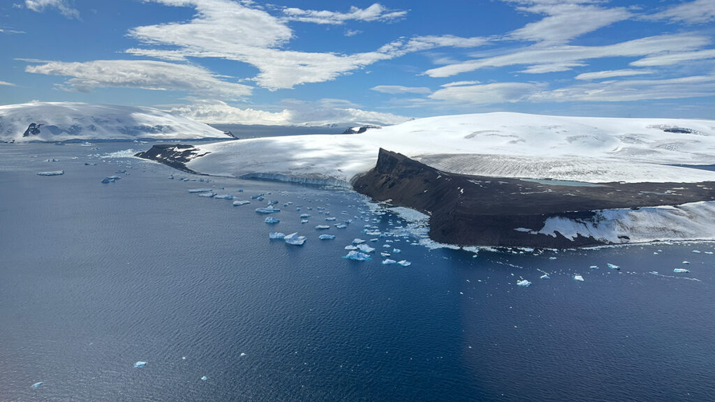
A critical ocean current that regulates Antarctica’s climate may have formed only once continents separated and winds aligned with new ocean passageways, according to a new study published in the Proceedings of the National Academy of Sciences of the United States of America.
Today, the Antarctic Circumpolar Current transports more than 100 times as much water as all of Earth’s rivers combined and, critically, insulates the Antarctic Ice Sheet from heat at lower latitudes. A clear picture of
Today, the Antarctic Circumpolar Current transports more than 100 times as much water as all of Earth’s rivers combined and, critically, insulates the Antarctic Ice Sheet from heat at lower latitudes. A clear picture of the origins of this current can help scientists further understand the relationships between contemporary ocean dynamics, the global climate, and ice formation in Antarctica.
“It’s very interesting to learn more about this current, how it developed, and what role it played in the climate change that was happening at that time,” said Hanna Knahl, a paleoclimatologist and doctoral student at the Alfred-Wegener-Institut in Germany and lead author of the new study.
The Birth of a Current
About 34 million years ago, Earth was undergoing a climatic shift, now known as the Eocene-Oligocene transition, during which atmospheric carbon dioxide decreased and the planet cooled.
Earth’s tectonic plates in the Southern Ocean moved away from each other, opening and deepening bodies of water such as the Tasmanian Gateway and the Drake Passage, which separate Antarctica, Australia, and South America.
For years, scientists hypothesized that the alignment of these newly formed waterways, along with westerly winds, could have channeled ocean water and spurred the formation of the Antarctic Circumpolar Current.
“The exact position of the westerly winds and their relative position to the [ocean] gateways have to click together.”
To test that hypothesis, Knahl and her colleagues simulated conditions of the early Oligocene Southern Ocean with a coupled model that included ocean dynamics, atmosphere and wind patterns, temperatures, ice sheet growth, and precipitation. The research team compared these simulations to data from actual Antarctic sediment cores and scans of the ocean floor.
Results confirmed that westerly winds were necessary for the Antarctic Circumpolar Current to form.
“The exact position of the westerly winds and their relative position to the [ocean] gateways have to click together,” Knahl said.
Joanne Whittaker, a marine geophysicist at the University of Tasmania who was not involved in the new study, was a coauthor of a 2015 study that proposed westerly wind alignment played a role in the formation of the current. Knahl’s study presents a more sophisticated model of the early Oligocene Southern Ocean and is a great next step in the investigation of the current’s origins, Whittaker said.
“They did a really nice job of taking a range of different people’s work and linking it all together,” she said.
Oligocene Understandings
“If you can have a model that works in the past, it’s going to give you confidence that it’s going to work for the future, as well.”
Scientists often use Earth’s past behavior to better understand how Earth systems may behave in the present or future. “If you can have a model that works in the past,” Whittaker explained, “it’s going to give you confidence that it’s going to work for the future, as well.”
The Eocene-Oligocene transition is a key to understanding the relationship between atmospheric carbon, ocean dynamics, and the glaciation of Antarctica, Whittaker said. Knowing how the current’s behavior affected carbon uptake millions of years ago helps scientists model how the present current’s behavior might also affect atmospheric carbon.
In addition to carbon uptake, the new research hints at how changes in westerly winds may influence the advance and retreat of the Antarctic Ice Sheet. Some modeling and proxy data indicate the westerly winds that spurred the Antarctic Circumpolar Current’s formation 34 million years ago have shifted in the past century and may continue to shift in the future. Understanding the role these winds initially played in the current’s development may shed light on the current’s present ability to guard the Antarctic Ice Sheet from warmer air masses.
There are still Oligocene patterns that require more research to sort out, though. For example, modeling in the new study showed interesting asymmetries in the timing of the development of different parts of the Antarctic Circumpolar Current, Knahl said. Scientists know from proxy data and modeling that similar asymmetry exists in the history of the Antarctic Ice Sheet; the ice sheet in East Antarctica began to form about 7 million years before the ice sheet began to form in West Antarctica.
“It could be interesting to see if there’s a connection between the asymmetries that we see here,” Knahl said. “Are they linked, or were they more or less independent?”
Citation: van Deelen, G. (2026), Widening channels and westerly winds together formed Earth’s strongest current, Eos, 107, https://doi.org/10.1029/2026EO260126. Published on 24 April 2026.