When Austin Bell first visited Hong Kong in 2017, he was struck by the chromatic vibrancy of its public basketball courts. Coming from the U.S., where these surfaces are often the neutral and uninteresting textures of asphalt and other materials, he was compelled to document the range of vivid color combinations, especially within the context of high-rise neighborhoods and urban infrastructure.
Bell set out to capture 2,549 outdoor basketball courts around Hong Kong—every single one there is in the region. The resulting series, SHOOTING HOOPS, not only highlights the physical courts but conveys a unique portrait of the region and the spaces where people can mingle. “To me, basketball courts are one of the most interesting subjects for aerial photography because they look so different from above than the ground,” Bell tells Colossal. “Their flatness and geometric design become an almost extraterrestrial tableau—like concrete crop circles.”
For such a densely populated place, Bell’s images are often devoid of people, giving the colorful scenes a subtle ghostly feel. Looking closely, though, you can often see passersby out and about, illustrating the abiding popularity of these urban recreation parks. “One of the newest ones is at a playground called Chung Sing, which is so named for the sound a bell makes, so the designers stylized the surrounding area with audio waveforms,” Bell says.
Bell captured the photos in 2019, trawling Google Maps’ satellite imagery and using his drone to explore spaces between buildings and trees. Over the course of 140 days of shooting during multiple visits, he took more than 40,000 photos. He often photographed from dawn to dusk, and it wasn’t unusual for him to shoot upwards of 100 courts in a day. Once, he meticulously planned a route and captured a mind-boggling 475 courts in a single day.
“The insane became mundane,” Bell says in a statement. “I had become an obsessive completist, unable to rest until I found every court in the city. My obsession was fueled by two desires: to show an unseen perspective of Hong Kong and to fully explore a city that I feel so captivated by.”
Find more on Bell’s Instagram, and purchase the photo book from his webshop.
Jan Erik Waider has a knack for capturing shorelines, volcanic eruptions, and glaciers at their most mesmerizing—shrouded in mist, glowing in the darkness, or illuminated by pale northern light. His atmospheric photographs of icy seas and rugged landscapes from Iceland to the Antarctic, focus on dramatic forms and cast remote places into a dreamy ethereality.
Most recently, Waider captured a striking phenomenon in the Baltic Sea, just off the coast of northern Germany. Fresh ice formed a thin layer on the rolling surface, creating faceted, polygon-like shapes that moved gently and rhythmically with the waves without breaking apart.
Waider’s aerial drone perspective creates an otherworldly, almost totally abstract effect. At first glance, it appears as though it could be a minimalist animation highlighting the interactions between water, light, and motion. “Soft evening light, fine crack lines, and shifting tones from warm gold to deep green turned this fleeting moment into a study of structure, depth, and calm,” Waider says.
Every wildfire starts small. The problem is that by the time most are detected, minutes have already passed and, under increasingly common conditions driven by a warming climate, a fire can grow beyond any tanker truck’s capacity to contain. The gap between ignition and coordinated response currently averages around 40 minutes. Firefighters have long understood the math: a spoonful of water in the first second, a bucket in the first minute, a truckload in the first hour. The XPRIZE Wildfire competition is an $11 million global effort to prove that autonomous systems, including AI-enabled drones, ground-based sensor networks, and space-based detection platforms, can collapse that window to 10 minutes. Our guest is Andrea Santy, who leads the program. She came to XPRIZE after nearly two decades at the World Wildlife Fund, where she watched conservation projects fall to wildfire. That experience sharpened her understanding of the stakes: wildfires are now the leading driver of deforestation globally, having surpassed agriculture. In places like the Amazon, the Congo Basin, and parts of tropical East Asia, a single fire can eliminate species found nowhere else on Earth. In cities, it can destroy entire neighborhoods in hours. On January 7, 2025, Santa Ana winds drove flames through Pacific Palisades and Altadena, destroying more than 16,000 structures, killing 30 people, displacing 180,000 residents, and generating between $76 billion and $130 billion in total economic losses from a single event. Annual U.S. wildfire costs, when healthcare, lost productivity, ecosystem damage, and rebuilding are included, are estimated between $394 billion and $893 billion. XPRIZE announced the five autonomous wildfire response finalists just over a year after the LA fires: Anduril, deploying its Lattice AI platform with autonomous fire sentry towers and Ghost X drones; Dryad, running solar-powered mesh sensor networks that detect fires at the smoldering stage; Fire Swarm Solutions, coordinating heavy-lift drone swarms that can deliver 100 gallons of water autonomously; Data Blanket, building rapidly deployable drone swarms for real-time perimeter mapping and suppression; and Wildfire Quest, a team of high school students from Valley Christian High School in San Jose who used multi-sensor triangulation to locate fires that can’t be seen from monitoring positions, solving the literal over-the-hill problem that any fire detection system faces.
Andrea Santy, program director of XPRIZE Wildfire, is our guest on Sustainability In Your Ear.
The conversation covers what the finalists demonstrated during semi-final trials at 40-mile-per-hour winds, why the decoy fire requirement — distinguishing a wildfire from a barbecue, a pile burn, or a flapping tarp — is one of the hardest AI classification problems in the competition, and how autonomous systems would integrate with existing incident command structures. Santy is direct about where progress is lagging: the testing is ahead of the regulations. Autonomous drones operating beyond visual line of sight and coordinating with manned aircraft in active fire emergencies require FAA frameworks that don’t yet exist at the necessary scale. There’s also the deeper ecological tension — the growing scientific consensus that many fire-adapted landscapes need more fire, not less, and that indigenous fire stewardship practices developed over millennia have a place alongside autonomous suppression technology. One XPRIZE finalist is already working with an indigenous community in Canada to pilot their heavy-lift drone system in a remote area where that community is exploring how the technology fits their land management approach. Meanwhile, the Trump administration’s FY 2026 budget proposes eliminating Forest Service state fire capacity grants, cutting vegetation and watershed management programs by 30%, and zeroing out $300 million in forest research funding — maintaining suppression spending while gutting the prevention and detection infrastructure that could reduce what there is to suppress. The engineering, Santy says, has arrived. Whether the institutions can move at the speed the crisis demands is the harder question.
Hello, good morning, good afternoon, or good evening, wherever you are on this beautiful planet of ours. Welcome to Sustainability In Your Ear. This is the podcast conversation about accelerating the transition to a sustainable, carbon-neutral society, and I’m your host, Mitch Ratcliffe. Thanks for joining the conversation today.
Fire season is coming, and we’re going to dig into how new technology may catch and contain fires in the first few minutes after ignition. There’s a saying among firefighters: you can fight fire in the first second with a spoonful of water, in the first minute with a bucket of water, and in the first hour with a truckload of water. The problem is that by the time most wildfires are detected, minutes have already passed, and in those minutes, under increasingly common conditions, a fire can grow beyond any tanker truck’s capacity.
On January 7, 2025, hurricane-force Santa Ana winds drove flames through Pacific Palisades and Altadena in Los Angeles, and in a matter of hours, more than 16,000 structures were destroyed. Thirty people were killed, and 180,000 residents were forced to flee. The total economic losses are estimated to be between $76 billion and $130 billion from a single fire event. And that was just one week in one city. In 2025, the U.S. recorded more than 61,500 wildfires that burned nearly 5 million acres, leading to annual U.S. wildfire costs of between $394 billion and $893 billion when you factor in the cost of healthcare, lost productivity, ecosystem damage, and the expensive task of rebuilding entire cities.
So there’s an identifiable gap in the current best practices, which take roughly 40 minutes from ignition to deliver a coordinated response. What if you could cut that to 10 minutes, when only a few buckets of water could extinguish a threat? And what if autonomous systems — AI-enabled drones and ground-based sensor networks — could detect a fire, distinguish it from a prescribed burn, and suppress it before getting a human on the radio?
That’s the challenge behind the XPRIZE Wildfire program, an $11 million global competition now entering its final year, and our guest today is Andrea Santy, the program director leading it. Andrea came to XPRIZE after nearly two decades at the World Wildlife Fund, and before that she spent time at the Smithsonian Institution, leading conservation and academic programs.
On January 29 — just after the one-year anniversary of those LA fires — XPRIZE announced the five finalist teams advancing in the autonomous wildfire response track of the competition. They include:
Andruil, a defense technology company deploying a Lattice AI platform with autonomous fire sentry towers and Ghost X drones that watch for fires at the moment they break out;
Dryad, a German company running solar-powered sensor networks that detect fires at the smoldering stage;
Fire Swarm Solutions, a Canadian team coordinating heavy-lift drone swarms that can carry 100 gallons of water autonomously to the point where a fire begins;
Data Blanket, building a rapidly deployable drone swarm system for real-time perimeter mapping and suppression; and
Wildfire Quest, a team of high school students from Valley Christian High School in San Jose who partnered with two aerospace companies to use multi-sensor triangulation to locate fires that cannot be seen from monitoring locations — because, after all, a lot of fires happen just over the hill.
A separate track of the competition, the space-based wildfire detection and intelligence program, includes 10 finalists from six countries who are heading to Australia in April for their own finals. Those teams will have one minute to detect all fires across an area larger than a state, and 10 minutes to deliver precise reports to firefighting decision-makers on the ground.
We’re going to talk with Andrea about what the finalists demonstrated during live trials, why the decoy fire requirement is one of the hardest AI classification problems in the competition, and how these autonomous systems would actually integrate with existing wildfire incident command structures. We’ll also dig into the tension between suppression technology and the growing scientific consensus that many landscapes need more fire, not less, and whether indigenous fire stewardship practices have a place in this conversation.
You can learn more about XPRIZE Wildfire at xprize.org/competitions/wildfire. Can autonomous drones and AI-driven sensor networks actually detect and suppress a wildfire in less than 10 minutes? Let’s find out right after this brief commercial break.
[COMMERCIAL BREAK]
Welcome to the show, Andrea. How are you doing today?
Andrea Santy 5:34
I’m doing great, Mitch. Thanks for having me.
Mitch Ratcliffe 5:34
Well, thanks for joining me. We’ve had XPRIZE leaders on the show a number of times, and you do such interesting work. You announced the finalists just at one year after the catastrophe in LA. How did that reshape the urgency and direction for the XPRIZE Wildfire competition?
Andrea Santy 5:34
It definitely focuses a more intense light on the competition and the need for these solutions. Climate change is driving more intense, more frequent wildfires all around the world, and so I think the urgency was already there. But when you have a disaster at the scale and scope of the LA fires, it absolutely changes the way that everybody thinks about wildfires.
Mitch Ratcliffe 6:04
What’s the realistic timeline for these technologies in the competition to potentially start changing the way that we fight fire and the outcomes of those fires?
Andrea Santy 6:14
So I’ll start by saying we were in LA when the fires started. XPRIZE has a lot of LA-based staff, and we’re originally LA-based, and we were having our staff meeting — so our entire staff was there. We knew from our prize that it was going to be very high risk, and so we were in touch with fire chiefs as the fires were starting. We were able to go out and see where the fires had gone through the Palisades and part of the city — basically 24 hours after it had happened.
It really, I will just say, definitely had a huge impact in terms of being able to see a landscape, communities, homes, schools, and businesses that had been devastated. A lot of the technology being integrated with these solutions can be deployed almost immediately. I think that as the fire agencies begin to get their hands on more of this technology, we’re going to have a hopefully relatively quick uptake. Cameras, sensors, satellite data — a lot of this is already being deployed. So we’re looking at how quickly and under what conditions it can help improve our detection. And then we have other components that I would say are going to have a longer timeline to full deployment.
Mitch Ratcliffe 7:56
It sounds like part of the problem, then, is just knitting all this together. Does that also apply to areas outside of major cities? Do we have the resources to do this on a nationwide basis?
Andrea Santy 8:10
Yeah, absolutely. We’re doing our testing for our space-based competition in Australia, so we’re looking at how you detect fires over vast areas from satellites as quickly as possible and deliver that information down within 10 minutes, with 15-minute updates. For our autonomous track, we’re testing in Alaska — so it will definitely be a real-world scenario where we can understand the capabilities of these technologies in forested areas, in really vast terrain, and under different environmental conditions. Part of why we’re working with these partners is because they’re great partners, but it also allows us to validate this technology under real-world, challenging conditions.
Mitch Ratcliffe 9:03
So how does the wildfire strategy change when this technology is in place? You’ve already mentioned that the climate crisis is accelerating the size and pace of these fires. Is the goal to suppress more fires earlier so that available resources can be deployed to those that actually break out? What’s the big-picture change in policy here?
Andrea Santy 9:26
XPRIZE really decided to double down on early detection and autonomous response, and we have two tracks. I’ll talk about the detection piece first because it’s digestible for everyone. Every wildfire starts small. They don’t start as a huge catastrophe — they start small, often in pretty remote areas. Sometimes they burn really fast, sometimes slower, depending on the conditions. But if you can address a wildfire at its very smallest phase, essentially post-ignition, that gives you the best chance to address it — either through autonomous suppression systems or through your fire service. If you have more eyes, ears, and noses on the landscape, the better your chance of getting that alert as soon as possible, which allows the fire service to decide how to prioritize their resources.
The second component we’re advancing is autonomous detection and response. Sensors and cameras handle the detection; the autonomous response system deploys, verifies there is a fire — that it’s not a barbecue but an actual wildfire that needs suppression — and places suppressant fully autonomously. That’s what we’re going to be testing in Alaska: can they execute this full end-to-end system? Is the technology integrated? Will it reach the scale and scope of the challenge and the geography? Because 1,000 square kilometers — which is our testing area — is roughly the size of San Antonio, Texas. The teams will have to find multiple fires and demonstrate persistent monitoring and persistent response. Imagine having a fire starting in a ravine: if you can get something out there in minutes, your chance of knocking it down — even just deterring the spread enough that firefighters can arrive — we hope will be a game changer.
Mitch Ratcliffe 12:13
We’re talking about autonomous drones. But one of the things that happened in the LA wildfire was that Santa Ana winds were so extreme, fixed-wing aircraft couldn’t fly. Can a drone perform in those conditions?
Andrea Santy 12:27
During our semi-final testing, our team traveled the world to observe these solutions in action. While not at scale, each of the five finalists was able to demonstrate that they could detect a fire, navigate to it, and suppress it fully autonomously over a small area. Coincidentally, relatively strong winds followed us — nothing like the Santa Ana winds, but we had 40-mile-per-hour winds pretty consistently during testing. It was odd, but it was helpful in terms of validating the technology.
Because you don’t have a human pilot, it’s not that helicopters and planes can’t fly — it’s that they can’t fly in that type of wind without putting a human at risk. This approach removes at least that human element. It’s going to continue to be a challenge, but many of the drones have a relatively high wind tolerance, and as the technology improves, the systems themselves are providing the input to stay balanced.
Mitch Ratcliffe 13:54
These systems are also being combined with sensor networks. Can you talk about how those are being deployed?
Andrea Santy 14:01
Some teams are really focused on ultra-early detection by deploying a sensor network — many, many sensors connected through a mesh network — allowing small, distributed sensors across a large area, which gives you great coverage. All of the different teams are competing under the same scenario, so we’ll get to see which technologies work under which conditions. There’s no single silver bullet that works in every condition, every geography, and every forest type. We’re also working on a pilot phase post-competition so the teams can continue to test and deploy, gaining even better understanding. Building trust with fire agencies — so they know what the technology can do under critical situations — is really important.
Mitch Ratcliffe 15:24
Do the fire agencies participate in these trials as well?
Andrea Santy 15:28
Absolutely. We have partners from different fire agencies in Australia — we’re doing our testing with the Rural Fire Service of New South Wales, which is a testing partner. Many of our judges come from different fire agencies across the United States and around the world. From the beginning, that was really an ethos we set forward — making sure this was done hand in hand with the fire agencies.
Mitch Ratcliffe 15:59
You’ve mentioned decoy fires. I’m curious how the trials will incorporate them. You mentioned barbecues — are you going to have people setting up small fires to lure the competition’s sensors?
Andrea Santy 16:11
I can’t say too much because testing hasn’t happened — I can’t give away the secret sauce. But yes — the teams do know they will have decoys and will need to ensure their technology ignores them. It can be anything from something flapping in the wind that resembles the color of fire all the way to barbecues or pile burns — anything that would confuse the technology.
Mitch Ratcliffe 16:52
And that could happen any day of the year. Really interesting. One of the most compelling things about the competition is the breadth of sources of ideas and the range of approaches — including even a high school team from Valley Christian High School in San Jose. What does that diversity tell us about where wildfire innovation will actually come from?
Andrea Santy 17:15
At XPRIZE, we believe that ideas can come from anyone, anywhere, and I think XPRIZE Wildfire really demonstrates what that looks like. We had teams from over 55 different countries enter the competition. We currently have six countries represented through our finals teams, and the range spans from Valley Christian — a high school team — through universities, startups, and all the way up to major industry. That truly spans the whole spectrum.
What I really love about our competition is that for many of the teams, this is both a company and a passion. Wildfires happen in so many places, and so many teams have been personally impacted. The high school team talked about growing up in areas where wildfires are a constant presence — they are very cognizant of the need for these solutions. Something remarkable: one in six Americans live in an area of wildfire risk, and 25% of Californians.
Mitch Ratcliffe 18:57
It’s a very tangible problem for so many of us, particularly in the West. And the smoke from fires in Canada is now familiar on the East Coast — it’s changed the very shape of life. This is a great place to take a quick commercial break. We’ll be right back.
[COMMERCIAL BREAK]
Welcome back to Sustainability In Your Ear. Let’s return to my discussion with Andrea Santy. She is Program Director of XPRIZE Wildfire — a competition headed into its final year with two groups of finalists vying to win shares of an $11 million prize to help commercialize their technologies.
Andrea, the autonomous competition requires teams to detect and suppress a high-risk wildfire in a 1,000-square-kilometer area — roughly the size of San Antonio — and do it within 10 minutes, while ignoring decoy fires. That’s four times faster than current best practices. Have any of the teams met that benchmark yet in the trials?
Andrea Santy 19:57
As I mentioned, the five teams advancing to finals all demonstrated they have end-to-end solutions to autonomously detect, navigate, and suppress a fire. Our semi-final testing was at a much smaller scale, and while some teams did it in less than 10 minutes, this finals competition is at a very large scale — and it is going to be challenging. Every XPRIZE is very audacious. We really want to push the limits, but we’re very confident we’re going to have a team that can do it. Still to be seen, but that is what finals is for.
Mitch Ratcliffe 20:42
Absolutely. It’s great that we’re testing in such diverse settings. Australia and Alaska seem very different. Is that actually the case, or are wildfire conditions globally roughly the same?
Andrea Santy 20:59
Very different. In Alaska, it will be wildfire season, and we’re testing in an area of much lower risk. The vegetation is different. The geography is different. The fuels — the plants and trees — are different. In Australia, the teams will be arriving as it comes out of summer and goes into fall, which means we don’t actually know exactly which specific days we’ll test, because the Rural Fire Service has to execute prescribed burns when it’s safe. We have a two-week testing window, with five planned days of testing, and approximately 20 fires of varying sizes that the teams will need to identify under different conditions and vegetation types.
Mitch Ratcliffe 22:11
Let’s talk a bit about the space-based prize. Lockheed Martin is adding a million dollars for the teams that can demonstrate the fastest and most accurate detection. Is detection turning out to be the harder technical problem — or is it the transition from detection to action, that coordination piece we talked about?
Andrea Santy 22:40
Lockheed Martin is supporting the autonomous wildfire response track — which we call Track B. The autonomous track requires teams to detect, navigate, and suppress, with all teams using drones. There’s a lot of different detection technology, from sensors that detect particulates up to cameras, and sensors and cameras mounted on drones.
Getting that detection into these autonomous response systems is really the step change — having something that communicates without human intervention, with drones that can fly under wind conditions and navigate to the right location, confirm there’s a fire, and then suppress it accurately. The teams will be testing on a moving fire — not a barrel of fire, but an actual fire that will be dynamic and small-scale but moving. That’s really challenging and requires quite a bit of system training. During semi-finals, accurately hitting the target was one of the harder challenges.
Mitch Ratcliffe 24:43
As you talk about it, it sounds like the transition from detection to addressing the fire appropriately — choosing the right suppression mechanism — is something you’ll continue to work on.
Andrea Santy 24:58
The teams are definitely still working on their systems. They have until June to have all of their systems working. Yeah, it requires a lot of different components.
Mitch Ratcliffe 25:20
And obviously that’s part of the bigger challenge — coordinating technological responses to a changing climate and acute situations like fire. As you observe the environment with these systems, are we also potentially identifying opportunities for prescribed burns in order to reduce fire risk?
Andrea Santy 25:45
Absolutely. While our competition is focused on detection and response to incipient-stage wildfires, I do think this technology can be utilized across many different scenarios — including prescribed burns, where you want to monitor large burn areas to ensure nothing escapes. That is definitely a use case, and anything that reduces our risk. Personally, I think it could provide peace of mind: if you have something on hand that can prevent a prescribed fire from spreading when weather conditions change unexpectedly, that’s enormously valuable.
Mitch Ratcliffe 26:43
Indigenous communities have managed fire for millennia using these kinds of burning practices. Have you engaged with tribal fire practitioners? Do they see autonomous technology as complementary to, or in tension with, their traditional fire stewardship programs?
Andrea Santy 27:02
We have engaged with some. I was just at a meeting where I was able to meet with a representative from an indigenous community in Canada, and they are actually going to pilot-test one of the team’s technologies — specifically a team with a heavy-lift drone. It was really exciting to talk with them and learn more about how they envision it being used. Their community is quite remote, and understanding how this technology could work within their context was a great conversation.
Mitch Ratcliffe 27:41
When I think about the swarm of drones approach to fire management, the regulatory landscape seems like a significant challenge. The FAA has been grappling with drone airspace management. Does the regulatory framework need to change significantly to accommodate these systems?
Andrea Santy 28:06
That’s an excellent question. Current regulations and protocol don’t allow drones in airspace with manned aircraft. As the technology gets better, there are definitely ways this can happen — there are pilots and tests already occurring with other partners looking at shared airspace for heavy-lift drones operating at higher altitudes. Beyond visual line of sight is one area where the testing is definitely ahead of where the regulations are.
Mitch Ratcliffe 28:55
What has your conservation career taught you about how technology deployment can shape our relationship with nature?
Andrea Santy 29:07
I got into this position in part because many of the projects I was working on at the World Wildlife Fund were being lost to wildfire, and I felt we hadn’t really understood the impact of wildfires on conservation. Wildfires are now the main driver of deforestation globally, having surpassed agriculture. In places like the Amazon, the Congo, and parts of tropical East Asia, there’s such critical biodiversity — and I think if we can use technology to monitor these areas, understand where fires are happening, and deploy appropriate responses, my hope is that we can save really, really important places. There are endemic species that only live in very, very small areas, and one fire could wipe out an entire species.
I also worked for a long time on projects where your goal was 20 to 50 years away. Being able to work with XPRIZE, where in three years we’ve seen an absolute transformation in both what the technology can do and how people understand what technology is for — I think we need more of these competitions, more technology applied to conservation problems. I’m really hopeful.
Mitch Ratcliffe 31:23
After three years with XPRIZE Wildfire, do you feel like we can turn back the rising incidence of wildfire and all the costs we’re seeing pile up when cities burn?
Andrea Santy 31:35
I think so. Communities and citizens around the world are understanding the problem at a deeper level. This is going to be all hands on deck. You need citizens and homeowners making sure they have zone zero — no vegetation around their homes. You need communities, city and state incentives, industry engagement. You need prescribed fire and better forest management policies that allow good fire on the landscape, and communities that encourage it. All of these factors together are what will get us to a new paradigm.
Mitch Ratcliffe 32:29
You mentioned raising awareness — this competition actually sounds like really good TV. Have you thought about how to tell this story of wildfire innovation so that people can get engaged with and behind this kind of activity?
Andrea Santy 32:49
We’ve discussed at length how we would be able to document some of the testing. For the autonomous wildfire response, it is a very big, vast area, and turning it into good TV is probably a step beyond us — but I think the teams have amazing stories to tell. We’re going to capture a lot of imagery to share that story out. We have a resource page that provides a lot of different information to homeowners and individuals about other really amazing organizations doing great work in the wildfire space.
Mitch Ratcliffe 33:47
How can our listeners follow along as you complete the project?
Andrea Santy 33:51
We’d love to have them follow along. The easiest way is xprize.org/wildfire — we have lots of information about the competition and the teams, lookbooks to learn about which teams are competing, social media updates, and a newsletter you can subscribe to. During the testing events we’ll be sharing quite a bit of good information. The events are in fairly remote, closed-system locations, so we can’t invite everyone there — but we’ll definitely be exploring how to make sure as many people as possible can get their eyes on what we’re doing.
Mitch Ratcliffe 34:42
Andrea, thank you very much for spending time with us today. It’s been a really interesting conversation.
Andrea Santy 34:48
Thank you so much. We hope all your listeners think deeply about wildfire and what they can do. Our goal is that collectively we can all work together to reduce this wildfire risk and keep good fire on the landscape.
[COMMERCIAL BREAK]
Mitch Ratcliffe 35:11
Welcome back to Sustainability In Your Ear. You’ve been listening to my conversation with Andrea Santy, Program Director of XPRIZE Wildfire, an $11 million global competition now in its final year. Learn more and follow the finalists at xprize.org/competitions/wildfire.
This conversation revealed, at least for me, that solutions to wildfire are arriving — but perhaps faster than the systems built to receive them can accept and use them. We’ll need more public funding to deploy these technologies, and right now we’re moving in the wrong direction. As wildfire damage grows, total federal wildfire spending is holding roughly flat at around $7 billion a year. However, the Trump administration’s FY 2026 budget proposes eliminating the Forest Service’s state fire capacity grants, cutting vegetation and watershed management programs by 30%, and zeroing out the $300 million in forest research funding that was in the budget previously. So we’re maintaining the suppression budget while cutting the prevention, detection, and research infrastructure that could reduce what we have to suppress.
Fortunately, we have XPRIZE Wildfire to take on some of the burden — but it’s not enough. Consider what Andrea said about early detection: every wildfire does start small. If autonomous systems can get suppressant on a fire quickly enough, it might not even need to be fully extinguished — just deterred enough that firefighters can arrive to finish the job. The technology to do that end-to-end and autonomously is already being demonstrated in the field. But Andrea was equally direct about what’s lagging: the testing is ahead of where the regulations are.
Consider autonomous drones operating beyond visual line of sight and coordinating with manned aircraft during active fire emergencies. For that to work, the FAA’s frameworks for widespread drone operations need to be reinvented. The recent closure of El Paso International Airport over nearby counter-drone laser testing is evidence of how unprepared we truly are for the innovations that are coming.
In short, the engineering has arrived, but institutions need support to integrate that engineering into their operations. A similar gap is evident in who’s doing the innovating: teams from over 55 countries entered this competition, and a high school team from San Jose made the finals by solving the problem of locating fires beyond ridgelines using multi-sensor triangulation — not because they had institutional backing, but because they had access to a well-defined problem and the drive to solve it, along with the incentive of XPRIZE’s $11 million award.
The XPRIZE premise that ideas can come from anyone, anywhere — it turns out — is literally true. But recognizing that changes nothing if the regulatory, procurement, and deployment systems still favor incumbents and slow-moving approval processes.
Underlying all these challenges is what Andrea brought to this work from nearly two decades at the World Wildlife Fund: wildfires are now the leading driver of deforestation globally, having surpassed agriculture. The game has changed, but policy is still anchored in now-outdated 20th-century strategies. One fire in the wrong place can drive a species to extinction, or it can burn a city to the ground.
Andrea said she’s hopeful — not because the problem is easy, but because in three years she’s watched a transformation in what technology can do and how people understand what technology is for. That hope is well earned. But it will only translate into outcomes if institutions move at the speed the crisis demands — citizens, homeowners, communities, industries, and policy, all moving together. The competition creates urgency; the systems around it need to act on and use the innovations being delivered.
So stay tuned for more conversations with people actually making sustainability happen, and I hope you’ll check out our archive of more than 540 episodes. There’s something worth sharing with anyone you know. Writing a review on your favorite podcast platform will help your neighbors find us — because, folks, you are the amplifiers that spread ideas to create less waste. Please tell your friends, your family, your co-workers, and the people you meet on the street that they can find Sustainability In Your Ear on Apple Podcasts, Spotify, iHeartRadio, Audible, or wherever they get their podcast goodness.
Thank you for your support. I’m Mitch Ratcliffe. This is Sustainability In Your Ear, and we will be back with another innovator interview soon. In the meantime, folks — take care of yourself, take care of one another, and let’s all take care of this beautiful planet of ours. Have a green day.
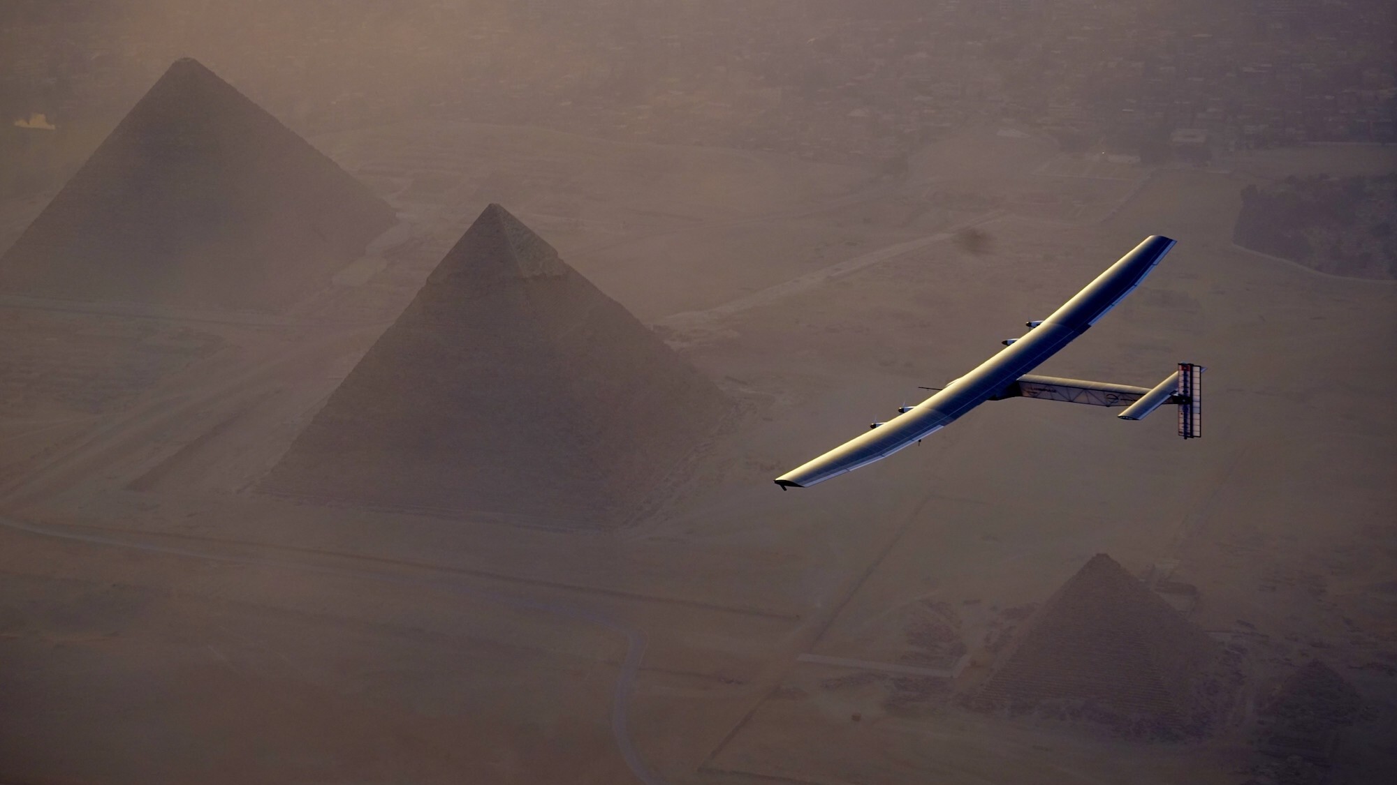
The groundbreaking experimental aircraft known as Solar Impulse 2 has met an untimely end. According to a National Transportation Safety Board report, the completely solar-powered plane crashed into the Gulf of Mexico during an autonomous test flight on May 4. While there were no injuries or fatalities, the wreck of the Solar Impulse marks an unfortunate end for one of the most impressive and inspirational planes in aviation history.
Solar Impulsewas first conceptualized in 2003 by Bertrand Piccard, the grandson of Swiss deep sea pioneer Auguste Piccard and the son of Jacque Piccard, the first person to reach the Mariana Trench. Piccard never intended the vehicle for commercial use, but instead envisioned it as a way to raise awareness for sustainable energy by building the first solar-powered plane capable of circumnavigating the globe. The first iteration, Solar Impulse 1, completed its inaugural test flight in 2009 followed by multiple additional trips over the next few years.
Construction on Solar Impulse 2 began in 2011. Even with a 232-foot wingspan that made it wider than a Boeing 747, the completely carbon-fiber frame ensured the plane only weighed about 5,100 lbs, making it about as heavy as a standard SUV. The 130-cubic-foot, nonpressurized cockpit included oxygen reserves and additional environmental equipment to enable a pilot to travel long distances at a maximum altitude of 39,000 feet. According to sUAS News, a total of 17,248 photovoltaic solar cells offered a peak power output of 66 kW to four electric motors and four lithium-ion batteries weighing nearly 1,400 lbs. Basic autopilot technology also allowed its sole occupant to sleep in 20 minute intervals.
Solar Impulse 2 made history in 2016 as the first fixed-wing, entirely solar-powered plane to circumnavigate the Earth. The feat was accomplished over the course of 16.5 months, with Piccard alternating piloting duties with Foundation co-founder André Borschberg and making 17 stops along the route. Solar Impulse 2 cruised at a ground speed between 31 and 62 mph, relying on the slower pace during evening portions of the trip.
In 2019, the Solar Impulse Foundation announced the sale of Solar Impulse 2 to Skydweller Aero for an undisclosed sum. The Spanish–American company’s plans were very different from the plane’s initial purpose. Instead of focusing on its solar capabilities, Skydweller hoped to pursue its military-related surveillance potentials, which included “carrying radar, electronic optics, telecommunications devices, telephone listening, and interception systems.”
After supplying numerous modifications, Solar Impulse 2 completed its first autonomous flight in Spain in 2023. The first entirely uncrewed, autonomous flight took place at Stennis International Airport near Bay St. Louis, Mississippi, the following year. At the time, Skydweller also confirmed its larger goal was to develop and supply a fleet of uncrewed, solar-powered planes capable of nonstop flight at latitudes between Miami (26°N) to Rio de Janeiro (23°S). These near-continuous operations would involve military and commercial contracts, allegedly at a much lower cost than current satellite options. The overhauled flagship aircraft reportedly crashed after losing power while flying over the Gulf of Mexico on May 4.
“We learned through social media about the crash of the Skydweller solar drone,” Piccard and Borschberg wrote in a statement provided to Popular Science. “The Solar Impulse team is saddened by the loss of an important technological flagship.”
Skydweller representatives did not respond to Popular Science at the time of writing. According to the Swiss news outlet SWI, part of Solar Impulse Foundation’s original sales contract with Skydweller stipulated the aircraft would eventually return to Switzerland for installation in the Swiss Museum of Transport in Lucerne.
“Very often when we speak of protection of the environment, it’s boring,” Piccard told Popular Science in 2013. “The first airplane [had] the technology of 2007. The second airplane [had] the technology of tomorrow.”
As NASA looks ahead towards Artemis III in mid-2027, the agency is sharing new details on several projects, including a future permanent moon base and a drone mission called MoonFall. The mission will send four drones to survey the surface of the moon’s South Pole to spot potential landing sites for future Artemis astronauts.
According to the update, the Jet Propulsion Laboratory (JPL) in Southern California has been developing the drone design and testing prototype hardware ahead of the scheduled 2028 launch. Each drone will land on the moon’s surface and gather high-resolution imagery of the terrain over the course of a single lunar day (up to 14 Earth days). After each drone’s last flight, its survive-the-night payload will continue to work for several months. Payloads that are designed to survive-the-night can endure the sub-zero temperatures of the lunar night, which can get as cold as -208 degrees Fahrenheit.
Each of the four drones should weigh about 550 pounds, and stand at four-feet tall and seven feet in diameter. They will use a Lunar Dashcam imaging system to create maps of the terrain. The drones will also be equipped with a laser retroflector array so that mission control can precisely locate the drones, a neutron spectrometer system to help determine how much (if any) subsurface water is present, and a spectrometer to measure radiation.
Texas-based Firefly Aerospace was selected to build the spacecraft that will transport the drones. Firefly’s Elytra spacecraft will carry the drones for a 45-day transit from the Earth to the moon. After entering lunar orbit, it will deorbit and perform a braking maneuver to send out the drones roughly 31 miles above the lunar South Pole.
No stranger to lunar exploration, Firefly Aerospace’s Blue Ghost lander became the first commercially built lander to reach the lunar surface in March 2025. While on the moon, Blue Ghost delivered 10 NASA instruments designed to gather lunar subsurface data and also snapped some beautiful images of a solar eclipse.
As of now, NASA and 66 other nations have signed the Artemis Accords. While not an international treaty, the Artemis Accords is an agreement for high-level principles of space exploration and provides a basic legal framework for exploring and developing the lunar surface during this century. However, the NASA-led Artemis group is in direct competition with an initiative led by China to explore the lunar South Pole and potentially extract its resources.
An independent security assessment conducted by U.S.-based cybersecurity firm OnDefend found that there are no security-related reasons for blocking DJI's products from being imported and sold in the United States.
Several times a day, a drone carrying high-capacity cameras and flashing red-and-blue lights whirs and rises from the rooftops of police stations across Hong Kong.
They emerge from a box-shaped docking system that slowly unfolds its doors to both sides. Some hover over the city’s billion-dollar villas with private pools and tennis courts; others whizz along streets bustling with people and traffic.
“Police Drone in Operation” banner in Sung Wong Toi, Kowloon, on May 12, 2026. Photo: Kyle Lam/HKFP.
Hong Kong police have been rapidly expanding their use of surveillance technology and automated drones. They have used drones to hunt down people who overstayed visas or gambled illegally.
According to the police force, these technologies will help deliver high-quality police services and optimise deployment and efficiency. Drones and cameras alike will also likely be combined with the use of artificial intelligence (AI) and facial recognition capabilities.
Drones will substitute some of the police’s foot patrols, and tens of thousands of surveillance cameras will be installed to assist in investigations and arrests.
Since a drone patrol pilot scheme was rolled out in May last year, the technology has helped arrest 54 people, including at least six wanted individuals, according to police. The force did not provide complete data, but at least half of the suspects allegedly committed non-violent crimes.
Hong Kong police officers demonstrate the use of unmanned aerial vehicles to journalists on May 19, 2025, days before the launch of the drone patrol pilot scheme. Photo: Hong Kong Police Force, via Facebook.
In one operation last month that spanned from West Kowloon to Lantau Island, police – with the help of drones – arrested 19 people suspected of immigration infractions and prostitution.
In another instance, police used drones to apprehend a group of eight middle-aged and elderly people who were gambling illegally in a public housing estate in Ma On Shan. Police also fined two drivers spotted crossing over into an oncoming traffic lane on a road to Shek O, using a drone.
Police have not responded to HKFP’s request for more details on how the drones helped during those arrests and investigations.
The increased use of drones is a response to China’s push for a “low-altitude economy,” which can be integrated into daily services ranging from deliveries to law enforcement, said Sky Yeung, chairperson of the DNT FPV Drone Association Hong Kong, China.
Businesses such as delivery companies and government agencies can test drone-use scenarios through a regulatory exemption scheme, and the government is taking steps to prepare for more drones in the air, whether operated commercially or by authorities, Yeung said.
Sky Yeung, chair of the DNT FPV Drone Association Hong Kong, China. Photo: DNT FPV Drone Association Hong Kong, China, via Facebook.
So far, police have not explicitly said anything about using drones for national security purposes, which has been a priority for Hong Kong’s law enforcement in recent years.
However, as an expert told HKFP, the capability is there.
Despite the stated purpose of police technology, once the law allows for an agitator, a national security risk, or a terrorist to be prosecuted, it becomes “malleable,” said Bryce Neary, former executive editor of the Seattle Journal of Technology, Environmental & Innovation Law. The US-based lawyer studied the use of drone and surveillance technology in Hong Kong, China, and the US.
If a government “make[s] a legal argument to do so, then the technology is in place and can be utilised regardless, and as needed essentially, when the government wants to change those terms for their use,” Neary told HKFP on the phone.
Moreover, there are potential privacy issues.
To people on the ground, police drones flying between 60 and 90 metres above ground will be barely noticeable to the naked eye, Yeung said, and their buzzing noise is unlikely to cause a nuisance, given other urban noise.
But nothing escapes the drones flying above us. Police drones, similar to those used in China, can typically “film everything” with “powerful lenses that can zoom in from a great distance, such as seeing what is inside a vehicle,” he said.
Police drones are marked with flashing lights and reflective decals for people to identify them, but these won’t be visible at their usual operating altitude, Yeung said. “Maybe you can see a flashing dot at night, but you wouldn’t notice it.”
Screenshot of a video showing police drone surveillance on Lamma Island. Photo: Hong Kong Police Force, via YouTube.
When asked about privacy concerns by HKFP, the police force said its drone patrols fly over “carefully” planned routes that cover only public areas and do not involve private spaces such as building interiors.
The drones “avoid unnecessarily flying close to individuals or private premises” – unless the situation warrants an investigation, in which case the drones would descend to lower altitudes to collect evidence, police said in a statement.
Video footage with no evidential value will not be kept for more than 31 days, and those obtained as evidence will be classified as such and handled by the investigating unit, according to the police statement.
Over the past two years, Hong Kong authorities have been introducing more surveillance technologies without hiccups at the “patriots only” legislature – and without protest.
A smart lamppost. File photo: GovHK.
This is in stark contrast to the time when angry demonstrators tore down experimental “smart” lampposts during the city’s 2019 protests and unrest. Discontent with shrinking political freedoms, protesters suspected that the lampposts would eventually allow authorities to conduct surveillance by adding facial recognition capabilities to their panoramic cameras.
The government strongly denied such plans at the time, and promised the cameras would be disabled or their resolution reduced to assuage concerns.
However, in a reversal, law enforcement is now considering adding facial recognition technology to its toolkit. Such systems may be connected to police surveillance cameras as soon as this year, police chief Joe Chow said in February. By 2028, police will install a total of 60,000 cameras across Hong Kong.
The goal is to have “as many cameras as possible” and replicate what’s in mainland China, where there is camera coverage “every two steps,” he said during a TV interview.
“Times have changed” compared with when society widely opposed increased surveillance and privacy issues, Chow added.
According to police, drone patrols will be used to combat crimes, identify traffic violations, and monitor traffic flows and crowds.
Hong Kong police officers demonstrate the use of drones to the media during the launch of the second phase of the programme on January 19, 2026. Photo: Hong Kong Police Force.
They can be used to track down suspicious individuals, such as someone who appears evasive when police are nearby, police said at press briefings.
They may also soon be equipped with artificial intelligence, but police have not specified whether the same facial recognition technology used on cameras would be applied to drones.
Present technology from mainland Chinese drone surveillance vendors can identify people, objects, behaviours, and events, according to their product catalogues. They can count and identify various types of vehicles moving on a road, or people in a crowd. They can detect illegally parked cars, smoke, or objects fallen onto power lines. They can spot when protest banners are unfurled.
Yeung pointed out drones’ ability to lock on to a target person and track them automatically as they move – a feature commonly used by police in the US. In short, drones film from above, while police operate on the ground.
During the first phase, which began in May last year, drones were deployed to Heung Yuen Wai, a border area with mainland China, and West Kowloon.
“Police Drone in Operation” banner on Lamma Island on March 24, 2026. Photo: Kyle Lam/HKFP.
They also covered busy downtown districts like Central and suburban residential areas such as Yuen Long and Tsuen Wan.
The police force purchased around 700 drones for HK$25 million during the past financial year, and will purchase another 56 in 2026-27 for HK$4.8 million, the Security Bureau told the legislature.
Other agencies also deployed drones for various purposes, from detecting sites at risk of landslides to patrolling several tourist hotspots during Golden Week holidays.
Last year, investigators from the Food and Environmental Hygiene Department apprehended individuals who illegally slaughtered a goat in a rural area, with the help of drones.
Several residents on Lamma Island said they were not aware of police drone patrols, despite prominent banners announcing their presence near the Yung Shue Wan ferry pier and in villages. They said they welcomed the idea that these patrols could prevent bike theft or burglaries, and expressed no worry about privacy issues.
The island’s resident, who asked to be identified only as Mark, said he believes ultimately it is the presence of police officers that will make a difference in deterring crime, something that drones above his head cannot replace. “What you need is your bobby to be walking and to be visible,” he said.
Neary believes a chilling effect is the intended purpose of police drones, more than the number or severity of crimes they manage to actually solve.
“Regardless if it’s actually effective in terms of what it’s doing, the fear of the fact that you’re being monitored at all times for any of these petty crimes in public or in private, I think, is going to be a big deterrent for you to do so,” he said. “And maybe that’s the point in the first place, right?”