Ancient Subduction May Have Seeded Today’s Critical Mineral Deposits
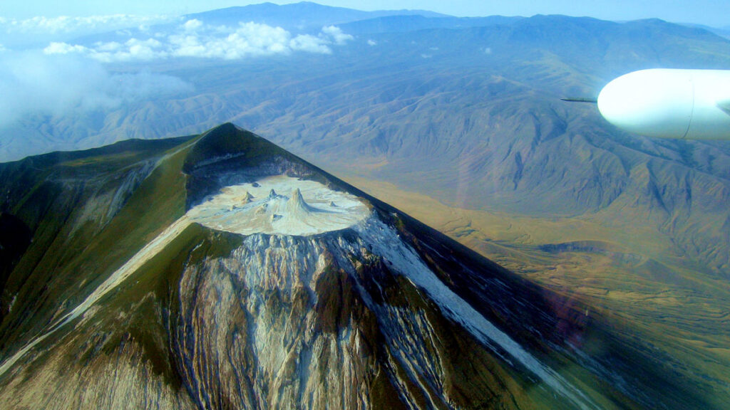
The weirdest volcano in the world may be Tanzania’s towering Ol Doinyo Lengai, an active peak that squeezes out a strange, low-temperature lava called carbonatite. Carbonatites are composed of more than 50% carbonate minerals, the same substances that form the ocean’s reefs. At Ol Doinyo Lengai, they are key components of the coldest lava on the planet.
Carbonatites are found on every continent and range in age from today-ish years old (in Tanzania) to about 3 billion years old (in Greenland). What’s more, they’re a major source of critical minerals.
In a new study published in Science Advances, a team of scientists led by Carl Spandler from Adelaide University in Australia identified a compelling correlation between carbonatites and specific sections of Earth’s continents—those proximal to past subduction zones.
Carbonatites and Critical Minerals
In the United States, the federal government defines critical minerals as those essential to the nation’s economic or national security. These minerals must also have supply chains that are vulnerable to distortions such as demand surges and foreign conflict. For example, most of the world’s terbium, used for everything from naval sonar systems to indoor lighting, comes from China. The United States considers terbium a critical mineral because the possibility of political or economic conflict within China or between China and another polity could directly or indirectly threaten the world’s supply of the element.
If you wanted to identify a rock that likely hosts rare earth elements, “carbonatite would be a good place to start.”
Critical minerals are either chemical elements (like terbium) or minerals. Important elements range from the familiar, like the lithium we need for batteries, to the sesquipedalian, like praseodymium, used for high-strength magnets. (Sesquipedalian means “having to do with a very long word.”)
Praseodymium is one of the 17 rare earth elements (terbium is another), all of which are considered critical minerals. Rare earth elements are not actually rare and are often (but not always) found in carbonatites. If you wanted to identify a rock that likely hosts rare earth elements, “carbonatite would be a good place to start,” said Kathryn Goodenough of the British Geological Survey, who was not involved in this study.
Fertilizing the Mantle
Much of Earth’s mantle is rock that remains after magma has been extracted—this mantle has been depleted. But carbonatites must come from mantle that’s quite the opposite—from parts that had to have been fertilized with volatiles containing trace metals, often critical minerals of interest. The question of how the mantle source for carbonatites came to be fertilized has no definitive answer.
Just as a garden can be fertilized in many ways ranging from synthetic sprays to coplanted cover crops, Earth’s mantle can be fertilized via myriad methods. “You must have volatiles or melts rising up from deeper in the mantle that are carrying metals with them,” Goodenough said.
For example, as a slab subducts beneath another tectonic plate, a volcanic arc typically arises above the zone at which the subducting slab reaches about 100 kilometers below Earth’s surface. This is the approximate depth at which the slab releases water, triggering melting in the overlying plate.
But fluids and melts can continue to exit the subducting slab far beyond the trace of the volcanic arc. That far out, the overriding plate almost always comprises a complete section of lithosphere—crustal lithosphere on top and mantle lithosphere on the bottom. The fluids and melts from the underlying slab, rich in halogens, carbon dioxide, phosphorus, and the like, rise into the overriding plate’s mantle lithosphere, changing the rocks via a process called metasomatism, Goodenough explained.
On the other hand, mantle plumes ascending from the core-mantle boundary are thought to be fertilized from a graveyard of subducted slabs that pond in the very deepest part of the mantle.
Spandler and his colleagues focused on testing whether that first method of fertilization, subduction-driven metasomatism, spatially correlates with carbonatites and rare earth element deposits. TL;DR—it does.
Fertilized Mantle Lithosphere
GPlates is a piece of software that allows users to rewind the movements of tectonic plates, exploring how continents have shifted their locations over the past 2 billion years. Using GPlates, Spandler’s coauthors Andrew Merdith and Amber Griffin, also of Adelaide University, mapped 43 polygons that denote regions of subduction lasting 100 million years or longer. These polygons, the authors infer, mark the locations of fertilized mantle lithosphere, which they call FML. These zones are thought to contain the good stuff—the critical minerals of interest.
“If [the correlation were] 100%, I wouldn’t believe it myself.”
Spandler and his colleagues compared the locations of carbonatites and rare earth elements with the polygons. They found that 67% of carbonatites and 72% of rare earth element ore deposits lie within these polygons. This correlation, though not perfect, suggests that mantle lithosphere fertilized by subduction could provide the source for many of these curious and critical deposits.
“If [the correlation were] 100%, I wouldn’t believe it myself because geology doesn’t work that way,” Spandler said.
Two Stepping
Spandler and his colleagues argue that carbonatites form in a two-step process. He emphasized that the new paper focuses on the first step—the process that led to fertilization of the eventual sources for carbonatites and rare earth element deposits.
The second step—the trigger—generates the carbonate-rich magma itself. It’s this event that provides the heat that causes melting of the mantle, said Richard Ernst, a scientist in residence at Carleton University in Canada who was not involved in this study.
“The trigger can be almost anything,” said Spandler, because the lithosphere needs only a nudge to melt. A plume can disrupt the structure of the lithosphere, triggering carbonatite magmatism, but so can continental rifting, he said. Indeed, Ol Doinyo is one of the mountains presiding over the East African Rift (which some scientists think also sits atop a plume).
Previous work by Ernst considered whether plumes could provide at least part of the source for some carbonatites by looking at the age of the deposits and those of nearby large igneous provinces—dramatic, long-lived outpourings of hot basalt thought to result from mantle plumes. In that work, Ernst and his colleague, the late Keith Bell, found the ages of large igneous provinces correlate with the ages of nearby carbonatite deposits; in short, the examples in that paper are potentially linked in both space and time.
Where carbonatite ages match those of nearby flood basalts from large igneous provinces, Spandler said, “I suspect that may just be the trigger mechanism.”
Plume Problems
For some carbonatites, there’s a time difference between when the mantle was fertilized and when the magmas were emplaced, explained Goodenough. “We can track that in several different localities,” she said. This observation would support something like the two-step process outlined above, as opposed to plumes driving the entire sequence.
Another problem with associating carbonatite formation exclusively with plumes, Goodenough said, is that carbonatites require cool conditions that result in relatively minor mantle melting. Plumes, and the large igneous provinces they appear to produce, are hot, and a lot. Plume proponents counter this critique by arguing that carbonatites are often found near the edges of large igneous provinces, away from the hottest zones.
Ernst noted, however, that though Spandler and his colleagues have made the spatial argument for subduction, “they haven’t made the isotopic argument that requires a subduction zone mechanism [for the source].” That sets up a testable hypothesis for future studies that could make use of existing data-rich geochemical studies of deposits within FMLs.
Moreover, even newer research may link the two camps, at least in some cases, with geochemical indicators pointing to both mantle plumes and mantle lithosphere being involved in forming some carbonatites. The latter component, said Ernst, may result from subduction-based fertilization as proposed by Spandler and his colleagues.
The Future of FMLs
“This is just an example of what we could do [with GPlates],” said Spandler. “In the next decade, we’ll see these models getting much more sophisticated and applied to all sorts of things.”
Computing power has improved to allow these models to run in a reasonable time frame. Plus, there’s lots of data. “We have a much better understanding about the history of each little bit of the continental crust around the planet,” he said.
And although people rightly point out that details become fuzzy in plate models that reach into the Proterozoic and beyond, “you’ve just got to pick one model and use it,” said Goodenough. “They’ve…taken the most widely available, repeatable model out there and used that.”
And on the basis of that model, Spandler and colleagues have shown a correlation between subduction—via FMLs—and carbonatites and rare earth element deposits. If someone comes up with another explanation, Spandler said, “that’s fine as well.”
—Alka Tripathy-Lang (@dralkatrip.bsky.social ), Science Writer