BK1684 Better Meals At Lower Cost 1951 (44)
29 May 2026 at 05:56


During the Victorian era, innovators made huge leaps with optical technologies. It was the period of the stereoscope and an early projector known as the magic lantern, not to mention that eyeglasses became more affordable and entered the mainstream. These advances also influenced scientific inquiry, making microscopes more powerful, and the pursuit of microscopy enabled researchers and enthusiasts to discover creatures invisible to the naked eye.
One of these enthusiasts was London-based educator and amateur scientist Charles Thomas Hudson. Along with other scholars and aficionados, he participated in interest groups. “As President of the Royal Microscopical Society and a Fellow of the Royal Society, Hudson was a leading figure in this growing scientific community,” says a statement from Osh Gallery, which is currently exhibiting a collection of unique illustrations in The Hudson Transparencies.
Curated by Luke Powell and Jody Hudson-Powell of design firm Pentagram, which runs Osh Gallery, the exhibition literally brings to light a number of colorful transparencies that Hudson used during his lectures. While they appear dark and even unfinished in a typical setting, “when lit from behind these intricate works transform into magical visions of life previously only glimpsed when viewed under a microscope,” the gallery says.
The Hudson Transparencies includes 58 original transparencies that measure a surprisingly large 37.8 by 29.5 inches. Each of the graphics’ proportions are “the equivalent of drawing ants the size of elephants,” says a statement. The animals and botanicals emerge through a combination of painted paper and perforations, which are made with lines and clusters of pinholes.
Hudson was particularly fascinated by rotifers, a phylum of zooplankton named for their so-called “wheel-bearing” characteristics. He also catalogued algae, protozoa, and larvae—such as that of the mayfly with its feather-like tail. Microscopic marine organisms were a particular favorite, though, and these back-lit images highlight the convergence of science and spectacular visuals that not only brought these creatures to life in a unique way for 19th-century viewers but continue to awe us today.
The Hudson Transparencies continues through June 11 in London. You might also enjoy Martin Kunz’s turn-of-the-century tactile graphics and Lorenz Oken’s seminal natural history work, Allgemaine Naturgeschichte Für Alle Stände.
Do stories and artists like this matter to you? Become a Colossal Member today and support independent arts publishing for as little as $7 per month. The article Vibrant Victorian-Era Transparencies Illuminate a Host of Microscopic Creatures appeared first on Colossal.
![]()
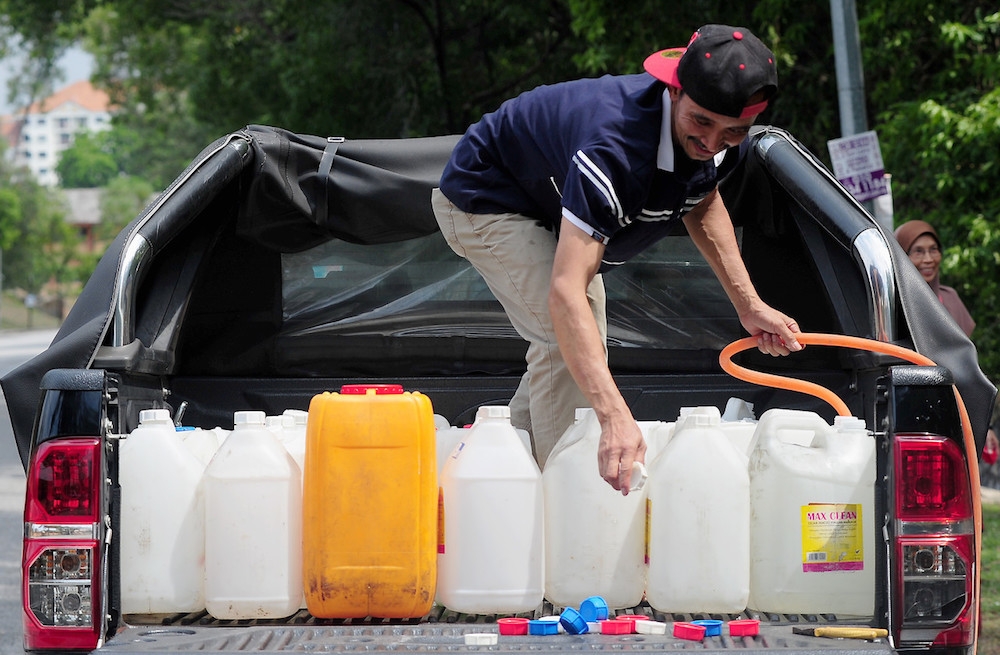
MIRI, June 10 — Sarawak Water Sdn Bhd (Sarawak Water) has confirmed that the 1,100mm main pipeline at Mile 7 Miri-Bintulu Road is the source of a major leak here.
In a statement posted on its Facebook page around midnight, Sarawak Water said the confirmation followed system testing and isolation works carried out on Tuesday night on the 750mm pipeline, which verified that the pipeline is in good condition and not affected by any leakage.
“Following the confirmation, the scheduled repair works on June 10 will proceed as planned and will involve repair works on the 1,100mm main pipeline.
“The works are expected to cause temporary water supply interruptions and low water pressure in several affected areas as previously communicated through the official infographic issued earlier,” it said.
The affected areas are Krokop, Jee Foh, Jalan Bulan Sabit, Piasau Area, Pulau Melayu/Taman Bayshore, Pujut, Vista Perdana, Desa Bahagia, Permyjaya, Desa Pujut, Desa Indah, Southlake, Tudan, Senadin, Lutong/Baram, Kampung Masjid, Sungai 7, Lambir, Kampung Bukit Beraya and Bukit Song pump station (under the Sarawak Rural Water Supply Department), KFC Tanjong, Jalan Temenggong Oyong Lawai Jau, Jalan Brighton, Sunlight Garden, Woodhouse Garden, Marina Commercial Centre Centre Point, Town Area, Pelita Commercial Centre, Jalan Miri Pujut, Kampung Lereng Bukit, Pujut Padang Kerbau, Lambir Prison area, New Barrack Sarawak Water, and Kampung Muhibbah, Kuala Baram.
The utility provider added it will provide water collection centres to enable the public to obtain clean water supply during the temporary interruption throughout the repair period.
“Consumers are advised to store sufficient water for essential use and to practise prudent water usage throughout the disruption and subsequent recovery period,” Sarawak Water said, adding it would continue to provide updates from time to time through its official communication channels.
On Tuesday, Sarawak Water acting chief executive officer Malseni Jamal said if the leak is traced to the 1,100mm pipeline, more than 70,000 consumers, which is equivalent to 70 per cent of the city’s population, could be affected by a supply interruption.
She also said repair works would begin on Wednesday (June 10), with valve closure scheduled for 5pm.
For more information, contact Sarawak Water on 085-426626. — The Borneo Post

![]()
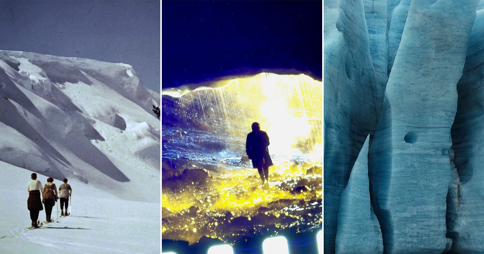
National Geographic's new documentary film, "Time and Water," grapples with a challenging, profound question: How do you say goodbye to what you never thought you could lose? Through archival footage, photos, art, and science, Academy Award-nominated director Sara Dosa follows acclaimed Icelandic writer and poet Andri Snær Magnason as he confronts the death of his country's glaciers, the loss of his grandparents, and the kind of world he hopes future generations can experience. The story's next chapters are being written at this very second.


Since 1989, Utah’s Great Salt Lake has lost some 70% of its surface area, reducing its ecosystem services and creating stretches of drying lake bed (playa) that send toxic dust into the air.
That drying ground has also provided opportunities for scientists to survey what lies below the lake’s floor. In a study published in Geosciences, researchers revealed glimpses of fresh water and salt water, with some fresh water lurking only a few meters below the surface. The work could provide clues for conserving the lake, a crucial resource for both the ecology and the economy of the region.
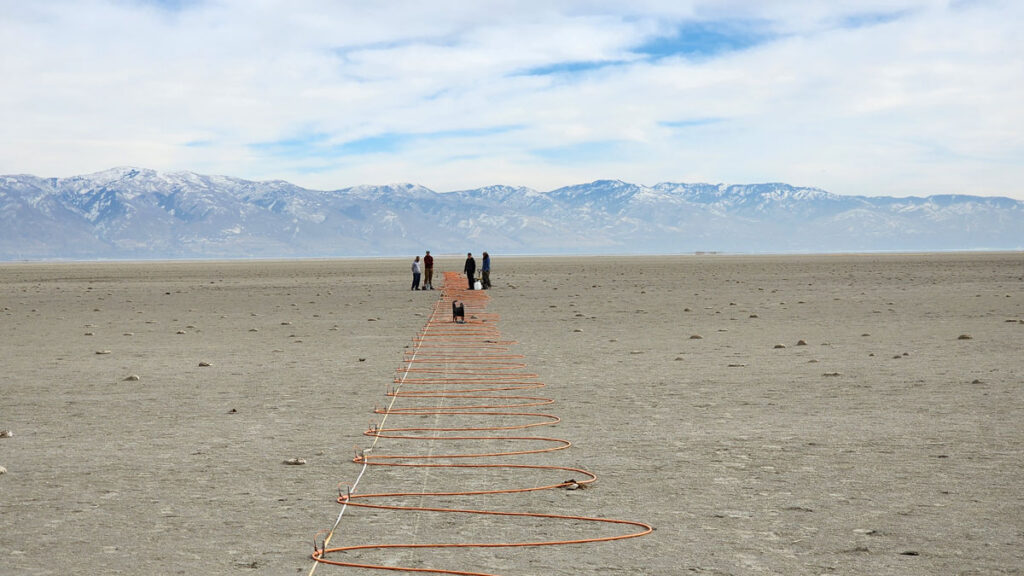
In 2023, Michael Thorne and colleagues began using a technique known as electrical resistivity tomography (ERT), which can reveal the presence of fresh or salty water, at dozens of spots near the southern and eastern edges of the Great Salt Lake. Thorne is a geophysicist at the University of Utah in Salt Lake City and a coauthor of the new study.
The lake’s desiccation allowed the researchers to access areas where “at previous times, you would never be able to do measurements because [they] would be underwater,” said Thorne.
Establishing a network of ERT sensors requires robust fieldwork. Over the course of long days in the field, Mason Jacketta, lead author of the new study, and others placed electrodes into the ground a few meters apart, making lines that stretched hundreds of meters. Between pairs of electrodes, they measured the resistance to electrical current. Salty water, filled with electricity-conducting ions, has lower resistance than fresh water.
Paired with information on the rock and sediment beneath the surface, as well as with measurements from nearby wells, the ERT data allowed the team to work out a profile of how electrical resistance varied with depth and to figure out what kind of water seeped through pores in the ground below. The team shared the results of their work on the southern part of the lake in Geosciences, while more in-depth findings about the eastern shore will appear in an upcoming publication.
“What this is really showing is that [fresh water is] prevalent all over the place.”
At many of the sites, Jacketta and others found fresh water near the surface.
“What this is really showing is that [fresh water is] prevalent all over the place,” said Elliot Jagniecki, a geologist at the Utah Geological Survey who wasn’t part of the work.
That fresh water was often in close proximity to patches of salty groundwater. At one spot in the southeastern part of the lake, the team found a shallow layer of brine. But right below that, at only 5 meters of depth, they encountered fresh water. At the team’s most northern study site, they found fresh water around 2 meters deep. On the southern shore, they found fresh water in some places as shallow as 2.8 meters.
The team’s results also helped explain curious features around the Great Salt Lake, including mounds made of salt and islands made of reeds.
The lacy-looking layers of the lake’s so-called mirabilite mounds form in the winter, when the cold freezes upwelling salty water, concentrating its salts. With measurements taken next to where some mirabilite mounds form, the researchers could visualize the underground conduits that send salty water to the surface.
While mirabilite mounds form close to shore, mounds made of Phragmites reeds appear in the lake’s interior as well as along its periphery. Thorne and his colleague William Johnson first noticed these mysterious circles popping up in Google Maps more than a decade ago. When they went to investigate, they found Phragmites.
“The population of Phragmites around the Great Salt Lake is really not allowing fresh groundwater to go back into the Great Salt Lake.”
In the new work, the team placed a line for electrical resistivity tomography straight through a Phragmites mound. These reeds wouldn’t be able to survive in the lake’s briny water, Thorne said, but the team’s results showed fresh water rising right to where the invasive reeds grew thick.
“The population of Phragmites around the Great Salt Lake is really not allowing fresh groundwater to go back into the Great Salt Lake,” said study coauthor Tonie van Dam, a geophysicist at the University of Utah. The reeds suck up some 70,000 acre-feet of fresh water that could go back into the lake, she said. In “sucking up [fresh water] for their own existence,” van Dam explained, the reeds crowd out native plant species that provide habitat for native birds.
Overall, the study provides a new picture of the fresh and salty groundwater beneath the lake and how these resources feed what people observe at the surface.
It’s also helped to prompt other work, Thorne said, including one recent study in which researchers used a helicopter carrying a wire loop to create and sense electrical currents underground. That study, published in Scientific Reports, suggested there could be a large amount of fresh water under one part of the lake.
But that work is a proof of concept, Jagniecki said, and accessing such potential aquifers might not be sufficient to help address the lake’s current desiccation. Even if they could, refilling them could take thousands of years. “I just don’t think that’s a solution,” he said.
Saline lakes are fragile ecosystems sensitive to climate change, Jagniecki said. The Great Salt Lake harbors plenty of life, such as brine shrimp that become food for a host of migratory birds that use the lake as a stopover. Mineral extraction and the use of brine shrimp for feed in aquaculture are important drivers of Utah’s economy.
Getting a better understanding of how saline lake systems function could be helpful in conserving them and maintaining the resources they provide humans, Jagniecki explained.
“It’s actually more than that. It’s a beautiful landscape,” he said.
—Carolyn Wilke, Science Writer
Wasaga Beach Provincial Park is one of Ontario’s most beloved natural places and provides habitat for endangered piping plovers. Stretching 14 kilometres along the Georgian Bay shoreline, it attracts more than one million visitors annually. Wasaga Beach is the most visited provincial park in the province. Beyond the crowds, the park protects dune ecosystems and habitats that are vital to other at-risk species like the eastern hognose snake, Hill’s thistle and the monarch butterfly.
Now, the Government of Ontario has removed provincial park protections from a significant portion of the beach and intends to transfer the lands to the Town of Wasaga Beach. This would weaken long-standing protections for these fragile habitats, and the piping plovers that depend on them.
The news came in May 2025, when the Government of Ontario announced the transferring of lands to the Town of Wasaga Beach to develop the waterfront for tourism.
In June, the government posted a proposal on the Environmental Registry (ERO #025-0694) to amend the Provincial Parks and Conservation Reserves Act. The proposal would remove several parcels of land from Wasaga Beach Provincial Park (roughly 60 hectares). Four of the park’s eight beach areas, including Areas 1 and 2, New Wasaga Beach and Allenwood Beach are included in the transfer. These areas are the most important piping plover habitat at Wasaga Beach.
At the end of November, the Government of Ontario passed Bill 68, Plan to Protect Ontario Act (Budget Measures), 2025 (No.2), which included a schedule removing these lands from regulation under the Provincial Parks and Conservation Reserves Act.
Public response to the proposal was overwhelmingly opposed, with approximately 98 percent of comments objecting to the removal of beach areas from the park. Key concerns focused on potential environmental impacts, legal and governance issues, and implications for public access and equity.
Despite this feedback, no changes were made to the proposal, citing the Town of Wasaga Beach’s commitments to maintaining public access, and avoiding development on the beach. Lands removed from the park will remain subject to Ontario’s environmental protection laws.
While the province has stated the beaches will remain public, what remains unclear is how these lands and their ecological integrity would be managed once they are no longer under provincial park legislation. These changes come at the hills of over 100 species losing protection under the province’s new Species Conservation Act.
The changes to both land ownership and species at risk laws significantly heighten the endangerment to piping plovers at Wasaga Beach.
Piping plovers are small shorebirds that nest directly on open sand, making them especially vulnerable to disturbance. In Ontario, they are listed as endangered under federal law, and Wasaga Beach has played a critical role in their population recovery. Successful nesting depends on a healthy dune ecosystem, undisturbed beaches, and careful seasonal management – conditions that can be easily disrupted if the lands are developed for tourism.
With decisions about shoreline use, tourism infrastructure, and beach “maintenance” now under municipal authority, activities like beach raking could threaten nesting piping plovers and weaken the dune systems that naturally protect the shoreline from erosion, storms, and climate impacts.
The replacement of Ontario’s Endangered Species Act with the Species Conservation Act narrows the definition of protected habitats, potentially leaving dunes and foraging areas outside nesting sites unprotected. In addition, the Government of Ontario intends to de-list migratory birds all together to “remove duplication for species already receiving federal protections.” To date, the federal government has been reluctant to implement the Species at Risk Act on non-federal lands, which is why complementary provincial legislation was always necessary.
In a 2025 media release, Ontario Nature’s Conservation Policy and Campaigns Director Tony Morris said transferring these areas to the town puts both wildlife and long-standing conservation efforts at risk.
Under municipal ownership, decades-long dune restoration and habitat protections, carried out by Ontario Parks, could disappear. Without the Provincial Parks and Conservation Reserves Act in place, Morris says the town would not be required to manage the land for ecological health.
In response to the loss of provincial protections, Ecojustice has filed a formal request on behalf of Environmental Defence and Ontario Nature, calling on the federal Minister of Environment, Climate Change and Nature Julie Dabrusin, to recommend an Emergency Order under the federal Species at Risk Act.
The emergency order request seeks immediate protection for critical piping plover habitat at Wasaga Beach. With the nesting season approaching, conservation groups are calling for action by March 1, 2026, noting that further delays could have serious consequences for the species’ survival and recovery in Ontario.
Call or email your MPP, and elected officials from the Town of Wasaga Beach to ask what they are doing to ensure Wasaga Beach remains a natural shoreline that balances tourism and a healthy ecosystem for the species that call it home.
You can also learn about the major projects and initiatives at the Town of Wasaga Beach.
If you are a resident of Wasaga Beach, visit this website to learn how you can get involved.
You can also contact Wasaga Beach’s Mayor and Council to ask them to protect this globally rare ecosystem.

![]()
![]()
![]()