Sluices (1967)
15 June 2026 at 08:24


A wonderful new paper on the huge Tracy Arm landslide and tsunami will have profound but challenging implications for the management of risk in an age of increased tourism and rapid climate change.
The journal Science has published an excellent new paper (Shugar et al. 2026) that examines the extraordinary 10 August 2025 landslide and tsunami at Tracy Arm fjord in Alaska. The paper is open access, so you can read it for yourself (it is very accessible), and there has been a plethora of media coverage (quite rightly).
I wrote about this event at the time and in the aftermath, but Shugar et al. (2026) is the authorative source. There is little for me to add to the science, but AGU Eos has a really excellent write up and explainer that I thoroughly recommend.
That large landslides occur in fjords is not a surprise, and that they can generate enormous displacement waves is also not news. We know that landslide occurrence in these environments in general is increasing, and specifically so in Alaska. However, this paper is the most comprehensive and systematic analysis of such an event, and it has shown the remarkable threat that these events can generate. The tsunami created by this landslide had a 481 metre run-up; it is remarkable that there were no fatalities. If a large cruise ship had been in the area, with passengers being ferried ashore on small boats and exploring the shoreline, the consequences would have been catastrophic. It is unsurprising then that cruise companies are now amending their itineraries.
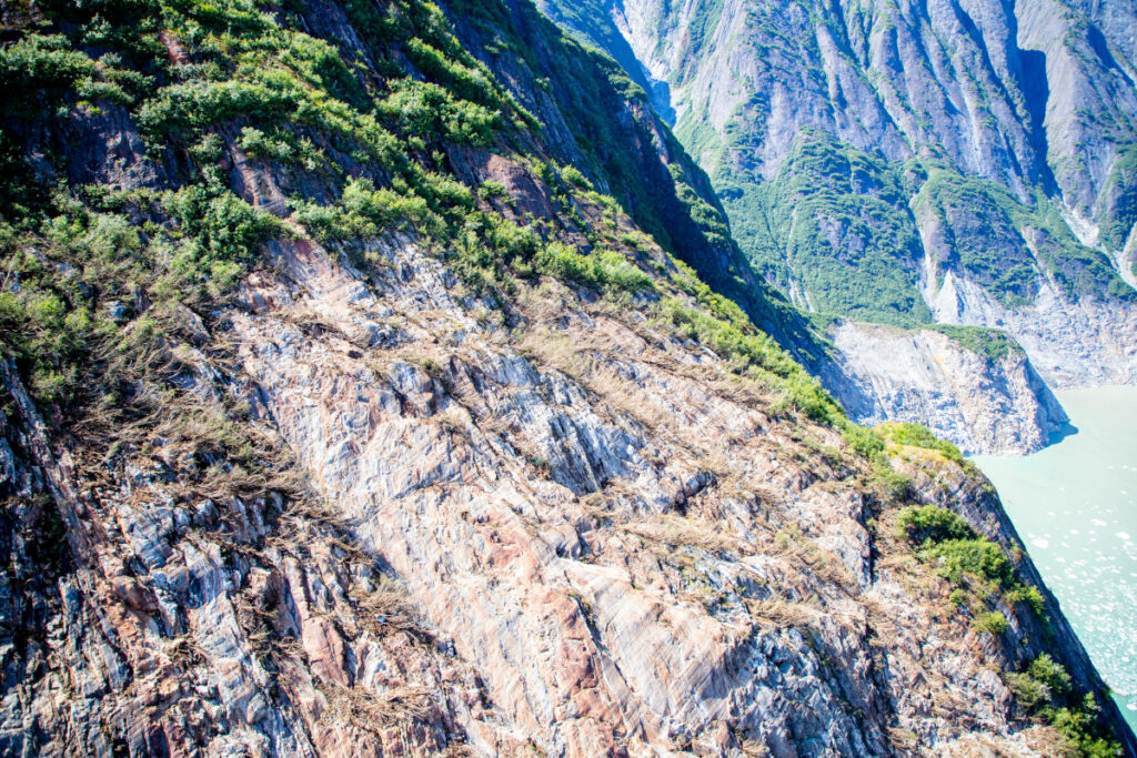
The USGS released the image below of the aftermath of the landslide and tsunami – scale is hard to understand in such images, but the crown of the landslide is over 1,000 metres above the level of the fjord, and the landslide had a subaerial volume of over 63 million cubic metres.
Shugar et al. (2026) has a brief section that examines the implications of this event, and of the understanding that it provides of the hazards posed by very large landslides in fjord settings. These are locations with extensive human activity – local communities, trade, fishing and tourism. There is some evidence that these landsldies are more likely to occur in the spring and summer months, when human occupation is higher. Our resilience to a tsunami wave that starts off being hundreds of metres high is low.
A case in point lies in Milford Sound in New Zealand, where (for example) an earthquake on the Alpine Fault has the potential to trigger a large landslide that could result in a major tsunami. Milford Sound is an extremely popular tourism location. Should such an event occur, and mass fatalities result, there is no doubt that the public inquiry would find that the societal risk was known and that it was probably unacceptable. However, to ban tourism, including cruise ships, in this area would carry heavy risks in its own right – it would profoundly impact the vital tourist economy of the area, on which many livelihoods depend. This is a substantial risk in its own right, and of course politics plays a major part too. Balancing these risks is a major challenge for any society.
Some hope is offered by the fact that this landslide showed substantial precursory seismic activity, which might represent a route to providing a warning for at least some of these rock slope failures. But research in this area is immature at the moment, and of course there will be no warning for a landslide triggered by a major earthquake.
So, the landslide at Tracy Arm fjord presents us with a host of major challenges, but it also represents a big step forward in our understanding of these events. Well done to Dan and his colleagues for another brilliant paper. I shall watch the debate with great interest.
Reference
Shugar et al. 2026. A 481-meter-high landslide-tsunami in a cruise ship–frequented Alaska fjord. Science, eaec3187. DOI:10.1126/science.aec3187


![]()
![]()


The Landslide Blog is written by Dave Petley, who is widely recognized as a world leader in the study and management of landslides.
I’ve not posted about Landslides in Art much in recent years – the most recent edition was almost two years ago – but loyal readers will know that this is a long running series of posts.
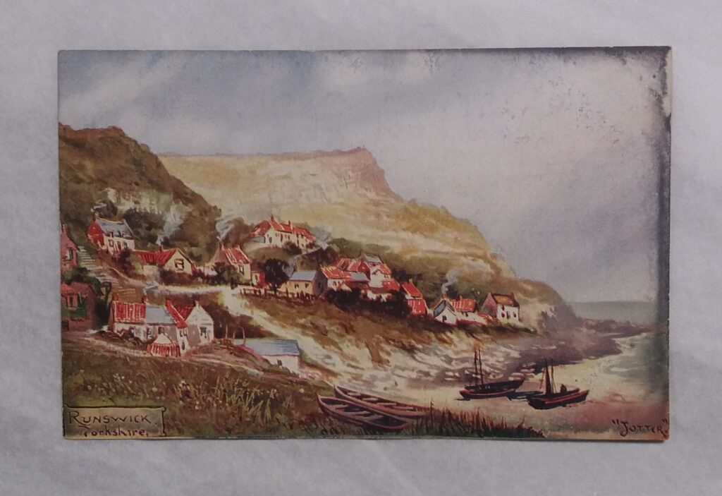
Anyway, I came across a page recently about the major landslide that struck the village of Runswick Bay in North Yorkshire. It includes a painting of the village with the above name, by an artist who signed themselves as “Jotter”. The painting is now in the collection of the Kirkleatham Museum:-
Now, there is a twist in that the landslide actually occurred in 1662, not 1664!
Runswick Bay is a picture postcard village in North Yorkshire of the UK, located at [54.53356, -0.75015]. The coastal part of the village is built on landslide debris, and there has been some movement in recent decades. In the late 1990s a very large scheme was put in place to mitigate the ongoing movement.
This is a Google Earth view of the village:-
The Tees Valley Museums site describes the landslide of 1662, noting that there were two major failure events. It is very fortunate that no-one was killed. The village was essentially destroyed and then rebuilt to the south of the original site.
It is probably true to say that the painting by Jotter is not a classic, but it does capture some interesting aspects of the site. First, it appears that the morphology is that of an existing landslide mass – this was probably a reactivation rather than a first time failure. Second, the toe was actively eroding, so maybe the two phase failure involved a collapse at the toe, which then destabilised the mass upslope? This would fit the eyewitness reports. Finally, note the mass in the background, which is also the result of a series of failure events.
There are many other major landslides along this section of coast – it is a classic area of UK mass movement geology. And it is truly beautiful too – visit if you can.


On 19 July 2025, record-breaking rainfall triggered a landslide that destroyed 26 buildings. Plans are now being developed to permanently relocate the community.
On 19 July 2025, parts of South Korea suffered record-breaking rainfall. Flooding and landslides were the inevitable outcome. One location that was particularly severely impacted was a small rural village called Sangneung, which is located in Saengbi-riang-myeon, Sangcheong. It is incredibly difficult to track down village locations in South Korea, but after a lot of work I think it is at [35.38269, 128.05740].
This landslide has attracted considerable attemtion because of the damage it has inflicted. There is a good news report that includes a drone video of the site on Youtube:-
The drone footage starts at 00:33.
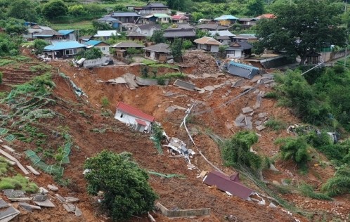
This image, released by the local government, also shows the site:-
There is a good reflective piece on the plight of the inhabitants of Sancheong, outlining why the village is now longer viable. A decision has now been taken to permanently relocate the village, and detailed plans are being developed.
This is an unusual intervention, but it is hard to argue that it is not the correct one.
Since 1994 there has been a 32 times increase in the number of research outputs with the keyword “landslide”.
In a couple of weeks time, I have the pleasure of being one of the invited speakers at the Landslide Risk and Geoengineering (LaRGE) Conference in Queenstown, New Zealand. Ahead of that presentation, I’ve been using Scopus to look at the growth of research in landslides since 1994, the year that I submitted my PhD thesis.
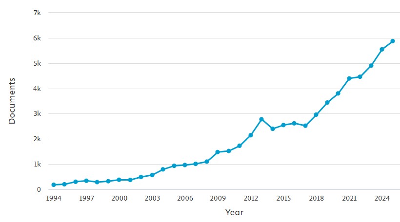
This graph, from Scopus, shows the number of research outputs per year that use the keyword “landslide”. It is simple and unfiltered:-
The extraordinary growth in productivity is clear – to put it into context, in 1994 the number of outputs was 182; in 2025, it was 5,875, a 32x increase. This is a remarkable improvement in the volume of our understanding of landslides, although it does not say anything about paradigm change.
It is interesting to look at some of the key publications for landslide research:-
The journal Landslides started in 2004 and has shown remarkable growth (although note it still represents a tiny proportion of the total outputs per year). There are also large increases in the journals Natural Hazards and Engineering Geology, and a smaller increase for journal Geomorphology. On the other hand, those journals that traditionally would have been associated with landslide research, such as QJEGH, Canadian Geotechnical Journal and Geotechnique, have remained essentially static over time.
I suspect that this represents a growth in the academic areas researching landslides, and in particular a diversification from geotechnical engineering to a much more broader range of research that encompasses people with an interest in geomorphology, remote sensing, geophysics and natural hazards.
There is one other element that is important here too, which is the growth of landslide research in China. This graph shows the same data as above but with China as the national affiliation of one or more author:-
The growth in landslide research productivity in China is explosive over the last ten years, and with 2,616 outputs in 2025, Chinese affiliated authors are now producing over 55% of the world’s landslide research. There is no doubt as to where the centre of gravity now lies in landslide science.