Normal view

  • ✇Eos
  • The 10 December 2025 Huangci landslide in Gansu Province, China Dave Petley
    A new paper in the journal landslides (Yang et al. 2026) details the 6.8 million cubic metre Huangci Landslide in China, which was a reactivation on a slope that has suffered two other failures in recent decades. On 10 December 2025, failure occurred in the large Huangci landslide in Gansu Province, China. The event is described in a new paper (Yang et al. 2026) in the journal Landslides (this link should provide access even though the article is paywalled). The paper is fascinating as t
     

The 10 December 2025 Huangci landslide in Gansu Province, China

22 May 2026 at 07:36
An image from a drone showing the aftermath of the 10 December 2025 Huangci landslide in China.

A new paper in the journal landslides (Yang et al. 2026) details the 6.8 million cubic metre Huangci Landslide in China, which was a reactivation on a slope that has suffered two other failures in recent decades.

Image of a landslide partially covered with a transparent sand-colored overlay and the words “The Landslide Blog,” centered, in white

On 10 December 2025, failure occurred in the large Huangci landslide in Gansu Province, China. The event is described in a new paper (Yang et al. 2026) in the journal Landslides (this link should provide access even though the article is paywalled). The paper is fascinating as this is a very complex slope with an interesting history of deformation, and because large failures do not usually occur in the winter months in this part of China.

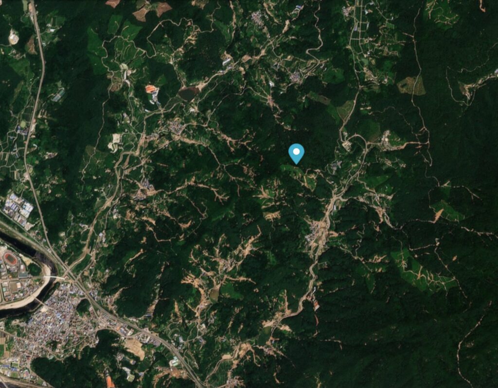
The location of the Huangci landslide is [36.08983, 103.32412]. This is a Google Earth image of the site, captured in 2004:-

Google Earth image of the Huangci landslide in 2004.

The geology consists of loess overlying mudstones. As the image above shows, the site had previously failed. The houses at the foot of the slope are the homes of people displaced in 1968 during the impoundment of the Liujiaxia Reservoir. Note also the farmland on the terrace behind the landslide. This is an arid area, so this farming requires extensive irrigation.

According to Yang et al. (2026), the failure that can be seen in the image above occurred on 30 January 1995. About 6 million cubic metres of rock and loess were involved, creating a landslide with a width of about 500 metres and a length of about 370 m.

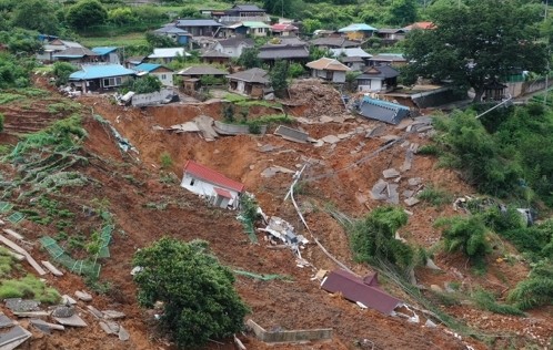
The Huangci landslide failed again on 14 May 2006, this time with a volume of about 4 million cubic metres. The image below, captured in 2013, shows the aftermath:-

Google Earth image of the Huangci landslide in 2012.

In this failure, 10 houses were destroyed.

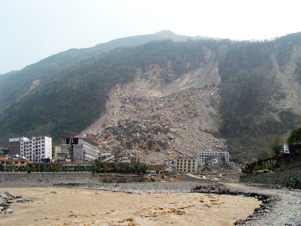
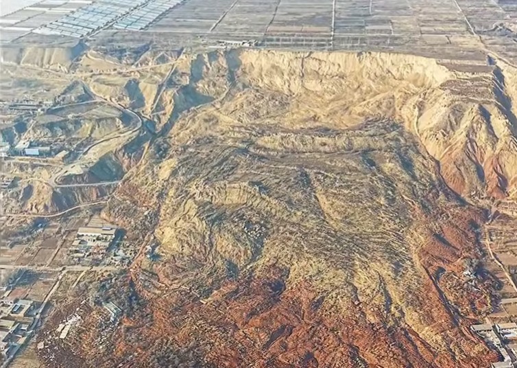
The most recent failure of the Huangci landslide occurred on 10 December 2025. This time, a larger mass failed, creating a landslide with a volume of about 6.77 million cubic metres, a length of up to about 740 metres and a width of up to about 420 metres. There is a spectacular video on Youtube showing the aftermath of the failure:-

The still below gives an impression of the scale of the failure:-

An image from a drone showing the aftermath of the 10 December 2025 Huangci landslide in China.
An image from a drone showing the aftermath of the 10 December 2025 Huangci landslide in China. Still from a video posted to Youtube by 阿龍說牆內事.

According to Yang et al. (2026), this failure destroyed 39 houses plus a range of infrastructure that includes power transmission systems, irrigation systems, water supply systems and transportation facilities. The site had been successfully evacuated as a result of a community-operated early warning system.

As noted above, this is an unusual time of the year for a landslide of this type. However, Yang et al. (2026) conclude that the underlying driver is irrigation on the terrace upslope from the landslide, driving a rise in the groundwater and consequent progressive deformation of the slope. This led to weakening of the mudstones that were buttressing the failure, eventually triggering collapse.

Reference

Yang, Y. et al. 2026. The reactivated Huangci landslide at the Heifangtai terrace, Gansu Province, China, on December 10, 2025Landslides. https://doi.org/10.1007/s10346-026-02765-2.

Text © 2026. The authors. CC BY-NC-ND 3.0
Except where otherwise noted, images are subject to copyright. Any reuse without express permission from the copyright owner is prohibited.
  • ✇Eos
  • Fatalities from landslides in earthquakes Dave Petley
    A new study (Sun et al. 2026) shows that in six earthquakes in China between 2010 and 2022, landslides and rockfalls were responsible for at least half of the total fatalities. It is well-established that landslides are a major cause of loss of life in earthquakes in mountainous areas. The seismology maxim that “it is not earthquakes that kill people, it’s collapsing buildings” does not apply in its pure form in mountains – landslides also kill large numbers of people. An earthquake
     

Fatalities from landslides in earthquakes

27 May 2026 at 08:41
An earthquake triggered landslide from the 2008 Wenchuan earthquake.

A new study (Sun et al. 2026) shows that in six earthquakes in China between 2010 and 2022, landslides and rockfalls were responsible for at least half of the total fatalities.

Image of a landslide partially covered with a transparent sand-colored overlay and the words “The Landslide Blog,” centered, in white

It is well-established that landslides are a major cause of loss of life in earthquakes in mountainous areas. The seismology maxim that “it is not earthquakes that kill people, it’s collapsing buildings” does not apply in its pure form in mountains – landslides also kill large numbers of people.

An earthquake triggered landslide from the 2008 Wenchuan earthquake.

However, the actual number of people killed by landslides in earthquakes is poorly understood. This is largely due to the challenges of collecting reliable information in the aftermath of a major earthquake, when the focus is on rescue and recovery rather than data collection. For this reason, many studies of landslide fatalities do not include seismically-triggered events. This is true of my own work.

However, a study has just been published (Sun et al. 2026) in the journal Natural Hazards Review that starts to address this issue. The paper nominally examines fatalities from all causes from earthquakes in China from 2001 to 2022. However, the authors note that the data has low reliability until 2010, so I’ll focus on the period from 2010 to 2022. I also note that the authors use the term “geological hazards“, which is a little broader than landslides. I should note that the paper isa broad look at fatalities from earthquakes – there is a much richer range of analyses than I will cover here.

In the period from 2010 to 2022, Sun et al. (2026) identified 14 earthquakes in which geological hazards caused loss of life. In some cases, the impacts were substantial. Thus, the M=6.5 3 August 2014 earthquake at Ludian in Yunnan led to 134 fatalities and 40 people missing from geological hazards from a total of 728 fatalities (c.24 % of the total), whilst the 5 September 2022 M=6.8 earthquake at Luding in Sichuan led to 76 geological hazard fatalities and 25 missing from a total of 118 fatalities (c.86% of the total). In six of the 14 examples, geological hazards caused at least 50% of the fatalities.

Sun et al. (2026) highlight that “fatalities from geological hazards concentrate in geologically complex, mountainous provinces, i.e., Sichuan, Yunnan, Gansu, Guangxi, and Guizhou”. They note that even small events can trigger fatal landslides – for example, six people were killed in a rockfall triggered by a M=4.3 earthquake in Guizhou in 2010, whilst a M=2.8 aftershock from the Yanjin earthquake in 2006 triggered a rockfall that killed a person.

This is an incredibly useful study. It starts to shed light on the impact of landslides in large earthquakes. It is not the definitive study, and questions remain – not least, the pattern of landslide losses in very large earthquakes, like the 2010 Wenchuan event, in which landslides were ferocious. But it forms the basis for such investigations, starting to fill a major gaps in our understanding.

Reference

Sun, B. et al. 2026. Causes Analysis of Earthquake-Related Deaths in Mainland China 2001–2022. Natural Hazards Review, 27 [2]. https://doi-org.ntu.idm.oclc.org/10.1061/NHREFO.NHENG-2458

Text © 2026. The authors. CC BY-NC-ND 3.0
Except where otherwise noted, images are subject to copyright. Any reuse without express permission from the copyright owner is prohibited.

Potential landslides and liquefaction from the 8 June 2026 M=7.8 earthquake offshore Mindanao in the Philippines

8 June 2026 at 07:19
Initial Pager map of landslide hazard from the 8 June 2026 earthquake offshore Mindanao in the Philippines.

Initial analyses suggest that the earthquake this morning has the potential to have triggered significant numbers of landslides and areas of liquefaction.

Image of a landslide partially covered with a transparent sand-colored overlay and the words “The Landslide Blog,” centered, in white

At the time of writing, the impacts of the M=7.8 earthquake that occurred offshore the south coast of Mindanao in the Philippines remain unclear. Initial reports in the local press suggest 15 fatalities so far, but as always it could be the case that there is no information from those areas most seriously impacted.

The USGS Pager site is the best source of information about potential landslide impacts, bearing in mind there is a high level of uncertainty. This estimates that the area exposed to landslides is at the high end of the “significant” scale and that the population exposed to landslides lies in the 1,000 to 10,000 people range. This is the Pager landslide hazard map:-

Initial Pager map of landslide hazard from the 8 June 2026 earthquake offshore Mindanao in the Philippines.
Initial Pager map of landslide hazard from the 8 June 2026 earthquake offshore Mindanao in the Philippines. Source: USGS.

The area with the highest level of landslide hazard is remote and rural, so we may not get good information from this area for a while.

The potential for liquefaction may be even more serious, with a broad swathe having a high level of hazard:-

Initial Pager map of liquefaction hazard from the 8 June 2026 earthquake offshore Mindanao in the Philippines. Source: USGS.

Past earthquakes have generated large liquefaction-related landslides on low angle slopes, with devastating effects. Hopefully, there won’t have been an event on this scale in Mindanao.

One final point to note is that the Philippines is just entering the typhoon season. Fortunately, Mindanao is sufficiently far south to be away from the main typhoon zone. However, these storms are so large that they can bring very heavy rainfall – see for example Typhoon Bopha in 2012. A similar event this year could have very significant consequences.

Text © 2026. The authors. CC BY-NC-ND 3.0
Except where otherwise noted, images are subject to copyright. Any reuse without express permission from the copyright owner is prohibited.
  • ✇Eos
  • The 19 July 2025 landslide at Sangneung village in South Korea Dave Petley
    On 19 July 2025, record-breaking rainfall triggered a landslide that destroyed 26 buildings. Plans are now being developed to permanently relocate the community. On 19 July 2025, parts of South Korea suffered record-breaking rainfall. Flooding and landslides were the inevitable outcome. One location that was particularly severely impacted was a small rural village called Sangneung, which is located in Saengbi-riang-myeon, Sangcheong. It is incredibly difficult to track down village locat
     

The 19 July 2025 landslide at Sangneung village in South Korea

29 May 2026 at 09:51
The aftermath of the 19 July 2025 landslide at Sangneung village.

On 19 July 2025, record-breaking rainfall triggered a landslide that destroyed 26 buildings. Plans are now being developed to permanently relocate the community.

Image of a landslide partially covered with a transparent sand-colored overlay and the words “The Landslide Blog,” centered, in white

On 19 July 2025, parts of South Korea suffered record-breaking rainfall. Flooding and landslides were the inevitable outcome. One location that was particularly severely impacted was a small rural village called Sangneung, which is located in Saengbi-riang-myeon, Sangcheong. It is incredibly difficult to track down village locations in South Korea, but after a lot of work I think it is at [35.38269, 128.05740].

This landslide has attracted considerable attemtion because of the damage it has inflicted. There is a good news report that includes a drone video of the site on Youtube:-

The drone footage starts at 00:33.

This image, released by the local government, also shows the site:-

The aftermath of the 19 July 2025 landslide at Sangneung village.
The aftermath of the 19 July 2025 landslide at Sangneung village. Image released by Sancheong County.

There is a good reflective piece on the plight of the inhabitants of Sancheong, outlining why the village is now longer viable. A decision has now been taken to permanently relocate the village, and detailed plans are being developed.

This is an unusual intervention, but it is hard to argue that it is not the correct one.

Text © 2026. The authors. CC BY-NC-ND 3.0
Except where otherwise noted, images are subject to copyright. Any reuse without express permission from the copyright owner is prohibited.
  • ✇Eos
  • Reports of landslides triggered by the 8 June 2026 M=7.8 earthquake offshore Mindanao in the Philippines Dave Petley
    To date news reports suggest two fatal landslides with a combined toll of 17 people. There are various news reports trickling in about the landslides triggered by the 8 June 2026 M=7.8 earthquake offshore Mindanao in the Philippines. As usual, the remote locations of many of the landslides means that the information is a bit hit and miss at this point. To date, the most serious event appears to have occurred at a community called New Aklan, located in Glan, Sarangani. It appears that
     

Reports of landslides triggered by the 8 June 2026 M=7.8 earthquake offshore Mindanao in the Philippines

9 June 2026 at 07:31
A failure in a coastal cliff at Sitio Buhangin, Barangay Patuco, Sarangani following the 8 June 2026 earthquake near Mindanao.

To date news reports suggest two fatal landslides with a combined toll of 17 people.

Image of a landslide partially covered with a transparent sand-colored overlay and the words “The Landslide Blog,” centered, in white

There are various news reports trickling in about the landslides triggered by the 8 June 2026 M=7.8 earthquake offshore Mindanao in the Philippines. As usual, the remote locations of many of the landslides means that the information is a bit hit and miss at this point.

To date, the most serious event appears to have occurred at a community called New Aklan, located in Glan, Sarangani. It appears that New Aklan is at: [5.7705 N, 125.3356]. News reports indicate that 13 people were killed, although there are also indications of additional fatalities in this area.

A further four people are missing under a landslide at Sitio Buhangin, Barangay Patuco, Sarangani. Patuco is in the area of [5.4770, 125.4859]. This appears to have been a failure on a coastal cliff:-

A failure in a coastal cliff at Sitio Buhangin, Barangay Patuco, Sarangani following the 8 June 2026 earthquake near Mindanao.
A failure in a coastal cliff at Sitio Buhangin, Barangay Patuco, Sarangani following the 8 June 2026 earthquake near Mindanao. Image tweeted by Radyo Pilipinas.

Over the next few days, satellite imagery should become available that will help identify the landslide impacts, but in the meantime Dan Shugar has identified some (using Planet imagery, I’d imagine):-

Text © 2026. The authors. CC BY-NC-ND 3.0
Except where otherwise noted, images are subject to copyright. Any reuse without express permission from the copyright owner is prohibited.
  • ✇Eos
  • The 19 July 2025 multiple landslide event in Sancheong, South Korea Dave Petley
    On 19 July 2025, intense, long duration rainfall triggered over 550 landslides in Sancheong, South Korea, killing at least 10 people. On 19 July 2025, extremely heavy rainfall triggered multiple landslides in Sancheong, South Korea. This event has been described by a new paper (Nguyen et al. 2026) just published in the journal Landslides. The paper is behind a paywall, but this link should give you access at the time of writing. The core of the affected area is at [35.4333, 127.9111]
     

The 19 July 2025 multiple landslide event in Sancheong, South Korea

15 May 2026 at 07:22
Planet Labs image of a part of the area affected by landslides during heavy rainfall in Sancheong County, South Korea on 19 July 2025.

On 19 July 2025, intense, long duration rainfall triggered over 550 landslides in Sancheong, South Korea, killing at least 10 people.

Image of a landslide partially covered with a transparent sand-colored overlay and the words “The Landslide Blog,” centered, in white

On 19 July 2025, extremely heavy rainfall triggered multiple landslides in Sancheong, South Korea. This event has been described by a new paper (Nguyen et al. 2026) just published in the journal Landslides. The paper is behind a paywall, but this link should give you access at the time of writing.

The core of the affected area is at [35.4333, 127.9111] (as usual, Landslides provides the location in degrees minutes and seconds when digital degrees is so much more useful – a pet frustration of mine!). This is a Planet Labs image of a part of the area, captured before the event. The marker is at the coordinate noted above:-

Planet Labs image of a part of the area affected by landslides during heavy rainfall in Sancheong County, South Korea on 19 July 2025.
Planet Labs image of a part of the area affected by landslides during heavy rainfall in Sancheong County, South Korea on 19 July 2025. Image copyright Planet Labs, used with permission. Image dated 10 July 2025.

And this is the same area after 19 July 2025:-

Planet Labs image of a part of the area affected by landslides during heavy rainfall in Sancheong County, South Korea on 19 July 2025.
Planet Labs image of a part of the area affected by landslides during heavy rainfall in Sancheong County, South Korea on 19 July 2025. Image copyright Planet Labs, used with permission. Image dated 23 July 2025.

And here is a slider to allow a comparison:-

Planet Labs image of a part of the area affected by landslides during heavy rainfall in Sancheong County, South Korea on 19 July 2025.Planet Labs image of a part of the area affected by landslides during heavy rainfall in Sancheong County, South Korea on 19 July 2025.
Images by Planet Labs.

Nguyen et al. (2026) have mapped 568 individual landslides triggered by this rainfall event, triggered by rainfall in the range of 498 – 619 mm over a c. 55 hour period. These landslides killed at least 10 people and caused damage to homes and infrastructure. It is estimated that the restoration costs are in the order of US$800 million.

In common with many other events of this type, the landslides are mainly shallow, translational failures in soil or regolith on steeper slopes. As I have frequently noted, such terrain is very susceptible to unusually intense rainfall events, which often trigger a cluster of landslides in close proximity. These often merge to form channelised debris flows. Nguyen et al. (2026) note however that their modelling indicates that it was a combination of the intensity of the rainfall and its duration that led to these failures.

As rainfall intensities increase due to climate change, we are seeing increasing numbers of these landslide clusters. I greatly welcome studies such as Nguyen et al. (2026) , which allow us to build understanding in each case.

Reference and acknowledgement

Nguyen, H.H.D., Song, C.H. & Kim, Y.T. 2026. Physically based data-driven analysis for large-scale investigation of the July 2025 rainfall-induced landslide in Sancheong, South KoreaLandslides. https://doi.org/10.1007/s10346-026-02778-x

Planet Team 20246. Planet Application Program Interface: In Space for Life on Earth. San Francisco, CA. https://www.planet.com/

Text © 2026. The authors. CC BY-NC-ND 3.0
Except where otherwise noted, images are subject to copyright. Any reuse without express permission from the copyright owner is prohibited.
  • ✇Eos
  • Our new paper: Extreme rainfall further endangers the world’s rarest great ape Dave Petley
    In November 2025, Cyclone Senyar generated extreme rainfall in parts of Sumatra, Indonesia, triggering thousands of landslides. Our new paper in the journal Current Biology demonstrates that these landslides might have a devastating impact on a critically endangered population of Tapanuli orangutan. In November 2025, Cyclone Senyar brought extreme rainfall to large parts of Sumatra in Indonesia. I have written about this on previous occasions – the rainfall triggered vast numbers of lan
     

Our new paper: Extreme rainfall further endangers the world’s rarest great ape

11 June 2026 at 07:19
Before and after satellite imagery of the impacts of Cyclone Senyar.

In November 2025, Cyclone Senyar generated extreme rainfall in parts of Sumatra, Indonesia, triggering thousands of landslides. Our new paper in the journal Current Biology demonstrates that these landslides might have a devastating impact on a critically endangered population of Tapanuli orangutan.

Image of a landslide partially covered with a transparent sand-colored overlay and the words “The Landslide Blog,” centered, in white

In November 2025, Cyclone Senyar brought extreme rainfall to large parts of Sumatra in Indonesia. I have written about this on previous occasions – the rainfall triggered vast numbers of landslides.

In my line of work, we often focus on the landslide impacts on the landscape, on human lives and on infrastructure. We rarely consider the impacts on th eanimal population. This is certainly a weakness that the Cyclone Senyar event brings to focus.

Part of the area devastated by the landslides is that slopes around the Batang Toru rover, an area of forest that is home to a rare species of orangutang. These great apes, Pongo tapanuliensis, live in a habitat known as the West Block of Tapanuli. There are only 800 individuals left in the wild, a situation that is highly precarious. The loss of even a small number of adults could tip the species towards extinction.

I was a part of a consortium of scientists that considered the landslide impacts of Cyclone Senyar on the habitat of these orangutangs. The results have just been published in the journal Current Biology (Meijaard et al. 2026) – the paper is open access and published under a creative commons license.

This image, from the paper, shows the landslide impacts of Cyclone Senyar:-

Before and after satellite imagery of the impacts of Cyclone Senyar.
Before and after satellite imagery of the impacts of Cyclone Senyar. From: Meijaard et al. (2026).

In the study area of 71,161 hectares, the mapping indicates that there were 50, 185 individual landslides, covering a surface area of 8,303 hectares. This is about 11% of the forested area. We then estimate the likely loss of the orangutang population, which is likely to be in the range of 18-120 individuals, with a central estimate of 58 individuals. This is likely to have been a devastating loss for this highly endangered population.

This level of habitat loss might also be placing a severe pressure on the remaining population, so further fatalities are very possible through, for example, reduced food availability.

The intensity of the rainfall was almost certainly supercharged by climate change. The impacts of Cyclone Senyar are being replicated widely – and of course we are now in the northern hemisphere tropical cyclone season again.

Our paper makes some policy recommendations for this population of orangutans. First, the government of Indonesia needs to permanently protect this area of forest against mining , palm oil and hydropower developments. Ideally, the protected area should be expanded. Second, Indonesia needs support for biodiversity-recovery, hazard forecasting and ecological restoration planning.

Reference

Meijaard, E. … Petley. D. … et al. 2026, Extreme rainfall further endangers the world’s rarest great ape. Current Biology. https://doi.org/10.1016/j.cub.2026.05.029

Text © 2026. The authors. CC BY-NC-ND 3.0
Except where otherwise noted, images are subject to copyright. Any reuse without express permission from the copyright owner is prohibited.
❌
Subscriptions