The man accused of storming the White House Correspondents’ Dinner spent years quietly acquiring his arsenal, purchasing a shotgun from a Torrance, California, firearms dealer eight months before the attack and a semi-automatic pistol two years earlier, according to a law enforcement intelligence profile reviewed by Bloomberg. Read More
The British royals are set to arrive on Monday for a visit hosted by President Trump, with a garden party, an address to Congress and a banquet on the schedule.
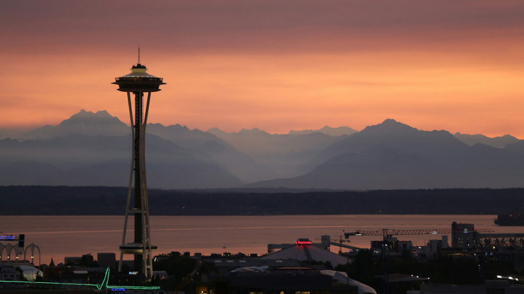
In the winter of 923, a magnitude 7.5 earthquake struck the heart of Puget Sound. Shorelines slid into the water, the seafloor rose up, and a tsunami swept through the region.
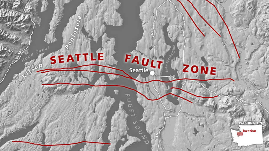
The Seattle fault zone, actually a mesh of faults that runs right under its eponymous city, was responsible for this quake. The fault continues to pose one of the deadliest threats to the Pacific Northwest; if a similar quake were to hit today, it would threaten millions of lives and cause billions of dollars in damage.
Two new papers dig into recurrence intervals, or the quiescent periods between earthquakes, for the Seattle fault zone. They offer good news and bad news: One study, published in Geology, found that in the past 11,000 years, the massive 923 event was the only quake of magnitude 7.5 or greater. The other study, published in GSA Bulletin, found that smaller, but still damaging, quakes occur more frequently than previously thought.
The new research indicates the worst-case scenario of frequent 923-style events is less likely than some scientists thought, said Harold Tobin, a geophysicist at the University of Washington and head of the Pacific Northwest Seismic Network, who was not involved in either study. But researchers also found that “the less worse, but still bad scenarios” are more likely than previously thought.
Meet the Seattle Fault
“For a fault that has had so much attention, there’s so much we still don’t know.”
The Seattle fault zone is a thrust fault system that stretches about 75 kilometers (46 miles) from the foothills of the Cascades east of Seattle to the Hood Canal, which runs along the shores of the Olympic Peninsula to the city’s west, passing under Seattle along the way.
Geologists began rigorously exploring the fault system in the early 1990s, intrigued by gravitational anomalies, uplifted marine terraces (stair-step geological formations along coastlines), and evidence of a roughly 1,000-year-old tsunami. All these features hinted at a major, shallow earthquake on a local fault zone—likely the 923 event.
But “for a fault that has had so much attention, there’s so much we still don’t know,” said Elizabeth Davis, an earthquake geologist at the University of Washington who led the Geology study.
The most pressing questions are how big quakes on the fault get, how often they hit, and, ultimately, what risks the fault poses to people who live in the Puget Sound area.
“It takes some real geologic sleuthing to get at those tough questions,” Tobin said.
Biggest Seattle Fault Quakes Are Rare
Davis focused on the activity of the main fault, which can generate the biggest quakes in the Seattle fault zone complex. It was responsible for the 923 quake. But the existing record went back only about 5,000 years.
“We just don’t know what the recurrence interval for these big quakes is,” Davis said. “We wanted to lengthen the record.”
To do so, Davis and her collaborators turned to marine terraces, the oldest of which date back to the end of the last ice age about 11,000 years ago. The quake in 923 raised terraces by about 8 meters (26 feet), and scientists wanted to look for similar-scale uplift in terraces all around the sound.
The researchers mapped more than 150 terraces around Puget Sound and measured their depths. After accounting for regional slopes, they estimated uplift over time that could have been caused by quakes.
They found that in that 11,000-year period, only the 923 event generated significant uplift. Thick sediment mantles could mask smaller events but not 923-scale quakes, Davis said.
Estimating true recurrence intervals requires knowing the timing of multiple events. But the finding is “not bad news,” she said. It provides some evidence that the recurrence interval is likely not shorter than about 5,000 years.
“That could give us more of a buffer between now and when the next big one like that will happen,” said Stephen Angster, a U.S. Geological Survey geologist who led the GSA Bulletin study.
Smaller, Damaging Quakes Are More Frequent
Angster’s work focused on Seattle’s secondary faults, which are smaller, mostly blind faults (those not visible at the surface) capable of generating damaging earthquakes. Previous work had shown that one of these secondary faults generated a magnitude 6.7 earthquake, highlighting the risk they pose. Angster wanted to explore rupture histories of these secondary faults, particularly whether they could rupture independently from the main fault.
The researchers used a suite of paleoseismic tools, including magnetic data, field and lidar mapping, trenches dug across faults, and geochronology. They studied two newly identified secondary faults that have orientations similar to the main fault.
They found three new earthquakes to add to the region’s seismic history, including the oldest and youngest events in the known record, which were around 11,000 years ago and in the early 1800s, respectively. The earthquakes appear to be evidence of ruptures that occurred independently of the main fault, suggesting that the smaller—but still dangerous—secondary faults should be considered in hazard modeling.
With that lengthened record and the addition of three quakes, the recurrence interval the researchers found was about every 350 years over the past 2,500 years. This timing refined the previous estimate of every several hundred years.
There also appears to be an increase in activity over the past 2,000 years.
“Maybe we should be paying attention to that,” Angster said.
What Happens Next
“There are other earthquakes that aren’t as big but that occur more frequently. Those might not be as catastrophic, but it would be a very bad scenario for Seattle” if such events occurred.
“These are both carefully done studies,” Tobin said. “We now have evidence that the 923 event was the biggest in 11,000 years. But there are other earthquakes that aren’t as big but that occur more frequently. Those might not be as catastrophic, but it would be a very bad scenario for Seattle” if such events occurred.
It’s still to be determined whether the risk from secondary faults will be incorporated into the National Seismic Hazard Model, which includes the 923 quake but not smaller ones along the Seattle fault zone. The secondary faults were left out in previous efforts because they are shorter than the minimum length required to be included and because of uncertainties in their potential rupture magnitude.
Citation: Dzombak, R. (2026), On the Seattle Fault, the biggest quakes aren’t the most likely, Eos, 107, https://doi.org/10.1029/2026EO260114. Published on 14 April 2026.
I’ve only ever been charged by two species. The bear took only a few quick steps before stopping.
The snowshoe hare, on the other hand, well, I was reminded of the killer bunny scene in Monty Python’s The Holy Grail.
In 2014, on a trail in Rocky Mountain National Park, a showshoe hare charged toward me. I wondered with confusion how this was going to play out when he stopped, regarded me for a moment, and then ran off into the woods just over a yard away from me.
I had a similar experience this summer while hiking the Sherman Peak Loop Trail in eastern Washington. As the trail snaked up the mountain, I rounded a curve to see a snowshoe hare sitting on the trail. I stopped. The hare didn’t move. Suddenly, he bolted in my direction. I wasn’t sure what his intention was when he slowed and came right at me. Initially, I thought he was going to blow past me. I was simply between him and a preferred hiding spot, a warren or a family. I stomped my foot as he stopped next to me, and he startled, disappearing into the brush. I’m not quite sure whether he touched my pant leg or not. It all happened so fast!
What is it with the snowshoe hare?!? I’m reminded of an exotic animal veterinarian who remarked, “If rabbits had canine teeth, they would rule the world.”
Starting up the connector trail, I thought, “This must be the bobcat’s favorite trail,” because of the frequency of feline scat along the route. Joining the loop on the east side, the habitat is dark and wet with a few mosquitoes. Small rivulets trickle across my path.
The forest opens up to a rock slide dotted with dense stands of willows, where I talk aloud as I hike so as not to surprise wildlife – snowshoe hare or otherwise.
Elk sign becomes prevalent along the way, and the mountainside is covered with huckleberry bushes. Two people on muleback, going downhill, pass me. Mules are perfect for this rugged terrain. As I continued to climb, rounding along the south side, wildflowers began to flank the trail. Although it’s called the Sherman Peak Loop, I expected it to loop around the peak. But with all of this elevation gain, I’m beginning to wonder if the peak isn’t part of the loop!
I think I can see my house from here!
The route levelled out at 1150 feet from where I started, 6400 feet above sea level, in an area of meadows, with lupine and pine trees. There’s mountain lion scat on the trail. I stop to look for any other signs of this beauty. I find that I’m more at ease where the trail traverses treed slopes thick with windfall. It seems like animals are less likely to hang out there, but these broad, park-like flat areas are easy-going for all of the animals that call this mountain home. It makes me a little uneasy.
From this side of the mountain, there are views southward for days. I can almost see my house from here!
A carpet of flowers looking west toward the Cascade Mountains
Passing the Kettle Crest trail junction, I round onto the west side. I leave the forest and stop in awe at the expansive fields of wildflowers – lupine, buckwheat, paintbrush.
The ground squirrels are chastising me, chattering from their lookouts downslope. I keep stopping to marvel at the beauty.
The carpets of flowers get more dramatic with each step. I can’t afford to linger as much as I’d like because I got a late start today.
Leaving the meadows, I enter a dense stand of young trees crowding the trail. Again, I’m talking to myself, nature, no one, and everyone. My bear spray is at hand, but it’s best that I don’t need it. I’m curving around to the north side on a gentle descent, again seeing the bobcat-sized feline scat that was so common at the outset. There’s another snowshoe hare just off the path. It’s not until this moment, when I see the scat and the hare together, that it clicks.
Snowshoe hares are lynx’s favorite prey. This could be lynx scat!!
This loop has been a wonderful trip through a diversity of habitats. Over three hours and five-and-a-half miles, every step was a delight.
If you’re interested in purchasing or licensing any images you see here, please email me at SNewenham at exploringnaturephotos.com, and I’ll make it happen.
Subscribe here to receive an email whenever a new blog posts.

")


